
Kodachrome Basin State Park
Encyclopedia
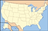
Kodachrome Basin is a state park
of Utah
, USA. It is situated 5800 feet (1,767.8 m) above sea level, 12 miles (19.3 km) south of Utah Route 12, and 20 miles (32.2 km) southeast of Bryce Canyon National Park
. It is accessible from the north from Cannonville
by a paved road and from the south by Road 400, a dirt road from the Page, Arizona
area to Cannonville, passable for most vehicles in dry conditions. A longer but paved route to Tropic from the south is also available via US-89
and SR-12.
with hot springs
and geysers, which eventually filled up with sediment and solidified. Through time, the Entrada sandstone
surrounding the solidified geysers eroded, leaving large sand pipes. Sixty-seven sand pipes ranging from two to 52 meters have been identified in the park.
and Henrieville
used the basin as a winter pasture. In 1948 the National Geographic Society
explored and photographed the area for a story that appeared in the September 1949 issue of National Geographic. They named the area Kodachrome
Flat, after the then relatively new brand of Kodak film they used. In 1962 the area was designated a state park. Fearing repercussions from the Kodak film company for using the name Kodachrome, the name was changed to Chimney Rock State Park, but renamed Kodachrome Basin a few years later with Kodak's permission.
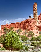 Primary recreational activities in Kodachrome Basin State Park include photography, wildlife watching, camping, and hiking the park's several trails. Popular sites include Chimney Rock, Shakespeare Arch, and Ballerina Geyser. Stargazing is popular as the park sees little light pollution. Grosvenor Arch
, an intricate double arch located ten miles south east of the park in the Grand Staircase-Escalante National Monument
is a popular destination for many visitors. Kodachrome Basin State Park has 27 campsites, two of which are group sites as well as available showers. Campsites can be reserved at Reserve America. There are also six cabins inside the state park for lodging owned by Scenic Safaris. The Kodachrome Basin Blog has contact information for reserving the cabins. Horseback rides are also available throughout the park and surrounding wilderness areas.
State park
State parks are parks or other protected areas managed at the federated state level within those nations which use "state" as a political subdivision. State parks are typically established by a state to preserve a location on account of its natural beauty, historic interest, or recreational...
of Utah
Utah
Utah is a state in the Western United States. It was the 45th state to join the Union, on January 4, 1896. Approximately 80% of Utah's 2,763,885 people live along the Wasatch Front, centering on Salt Lake City. This leaves vast expanses of the state nearly uninhabited, making the population the...
, USA. It is situated 5800 feet (1,767.8 m) above sea level, 12 miles (19.3 km) south of Utah Route 12, and 20 miles (32.2 km) southeast of Bryce Canyon National Park
Bryce Canyon National Park
Bryce Canyon National Park is a national park located in southwestern Utah in the United States. The major feature of the park is Bryce Canyon which, despite its name, is not a canyon but a giant natural amphitheater created by erosion along the eastern side of the Paunsaugunt Plateau...
. It is accessible from the north from Cannonville
Cannonville, Utah
Cannonville is a town in Garfield County, Utah, United States, along Utah Scenic Byway 12. In the 2000 census, the population was 148, a small increase over the 1990 figure of 131.-Geography:Cannonville is located at ....
by a paved road and from the south by Road 400, a dirt road from the Page, Arizona
Page, Arizona
Page is a city in Coconino County, Arizona, United States, near the Glen Canyon Dam and Lake Powell. According to 2005 Census Bureau estimates, the population of the city is 6,794.-Geography:Page is located at ....
area to Cannonville, passable for most vehicles in dry conditions. A longer but paved route to Tropic from the south is also available via US-89
U.S. Route 89 in Utah
In the U.S. state of Utah, U.S. Route 89 is a long north–south state highway spanning more than through the central part of the state. Between Provo and Brigham City, US-89 serves as a local road, paralleling Interstate 15, but the portions from Arizona north to Provo and Brigham City...
and SR-12.
Geology
Geologists believe Kodachrome Basin State Park was once similar to Yellowstone National ParkYellowstone National Park
Yellowstone National Park, established by the U.S. Congress and signed into law by President Ulysses S. Grant on March 1, 1872, is a national park located primarily in the U.S. state of Wyoming, although it also extends into Montana and Idaho...
with hot springs
Hot Springs
Hot Springs may refer to:* Hot Springs, Arkansas** Hot Springs National Park, Arkansas*Hot Springs, California**Hot Springs, Lassen County, California**Hot Springs, Modoc County, California**Hot Springs, Placer County, California...
and geysers, which eventually filled up with sediment and solidified. Through time, the Entrada sandstone
Entrada Sandstone
The Entrada Sandstone is a formation in the San Rafael Group that is spread across the U.S. states of Wyoming, Colorado, northwest New Mexico, northeast Arizona and southeast Utah...
surrounding the solidified geysers eroded, leaving large sand pipes. Sixty-seven sand pipes ranging from two to 52 meters have been identified in the park.
History
Evidence near the park suggests that Native Americans were the first to wander through the area. Around the turn of the 20th century, cattlemen from CannonvilleCannonville, Utah
Cannonville is a town in Garfield County, Utah, United States, along Utah Scenic Byway 12. In the 2000 census, the population was 148, a small increase over the 1990 figure of 131.-Geography:Cannonville is located at ....
and Henrieville
Henrieville, Utah
Henrieville is a town in Garfield County, Utah, United States, along Utah Scenic Byway 12. As of the 2000 census, the town population was 159.-Geography:Henrieville is located at ....
used the basin as a winter pasture. In 1948 the National Geographic Society
National Geographic Society
The National Geographic Society , headquartered in Washington, D.C. in the United States, is one of the largest non-profit scientific and educational institutions in the world. Its interests include geography, archaeology and natural science, the promotion of environmental and historical...
explored and photographed the area for a story that appeared in the September 1949 issue of National Geographic. They named the area Kodachrome
Kodachrome
Kodachrome is the trademarked brand name of a type of color reversal film that was manufactured by Eastman Kodak from 1935 to 2009.-Background:...
Flat, after the then relatively new brand of Kodak film they used. In 1962 the area was designated a state park. Fearing repercussions from the Kodak film company for using the name Kodachrome, the name was changed to Chimney Rock State Park, but renamed Kodachrome Basin a few years later with Kodak's permission.
Recreational activities
Grosvenor Arch
Grosvenor Arch is a unique sandstone double arch located within Grand Staircase-Escalante National Monument in southern Utah. It is named to honor Gilbert Hovey Grosvenor , a president of the National Geographic Society, publishers of the National Geographic Magazine.Located in northern Kane...
, an intricate double arch located ten miles south east of the park in the Grand Staircase-Escalante National Monument
Grand Staircase-Escalante National Monument
The Grand Staircase-Escalante National Monument contains 1.9 million acres of land in southern Utah, the United States. There are three main regions: the Grand Staircase, the Kaiparowits Plateau, and the Canyons of the Escalante. President Bill Clinton designated the area as a U.S. National...
is a popular destination for many visitors. Kodachrome Basin State Park has 27 campsites, two of which are group sites as well as available showers. Campsites can be reserved at Reserve America. There are also six cabins inside the state park for lodging owned by Scenic Safaris. The Kodachrome Basin Blog has contact information for reserving the cabins. Horseback rides are also available throughout the park and surrounding wilderness areas.