

Geography of Costa Rica
Encyclopedia
Costa Rica
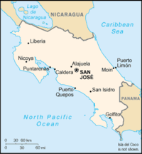
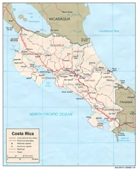
Costa Rica , officially the Republic of Costa Rica is a multilingual, multiethnic and multicultural country in Central America, bordered by Nicaragua to the north, Panama to the southeast, the Pacific Ocean to the west and the Caribbean Sea to the east....
is located on the Central American Isthmus, surrounding the point 10° north of the equator
Equator
An equator is the intersection of a sphere's surface with the plane perpendicular to the sphere's axis of rotation and containing the sphere's center of mass....
and 84° west of the prime meridian
Prime Meridian
The Prime Meridian is the meridian at which the longitude is defined to be 0°.The Prime Meridian and its opposite the 180th meridian , which the International Date Line generally follows, form a great circle that divides the Earth into the Eastern and Western Hemispheres.An international...
. It borders both the Caribbean Sea
Caribbean Sea
The Caribbean Sea is a sea of the Atlantic Ocean located in the tropics of the Western hemisphere. It is bounded by Mexico and Central America to the west and southwest, to the north by the Greater Antilles, and to the east by the Lesser Antilles....
(to the east) and the North Pacific Ocean
Pacific Ocean
The Pacific Ocean is the largest of the Earth's oceanic divisions. It extends from the Arctic in the north to the Southern Ocean in the south, bounded by Asia and Australia in the west, and the Americas in the east.At 165.2 million square kilometres in area, this largest division of the World...
(to the west), with a total of 1,228 km of coastline (212 km on the Caribbean coast and 1,016 km on the Pacific).
Costa Rica shares a border with Nicaragua
Nicaragua
Nicaragua is the largest country in the Central American American isthmus, bordered by Honduras to the north and Costa Rica to the south. The country is situated between 11 and 14 degrees north of the Equator in the Northern Hemisphere, which places it entirely within the tropics. The Pacific Ocean...
to the north (309 km long border) and with Panama
Panama
Panama , officially the Republic of Panama , is the southernmost country of Central America. Situated on the isthmus connecting North and South America, it is bordered by Costa Rica to the northwest, Colombia to the southeast, the Caribbean Sea to the north and the Pacific Ocean to the south. The...
to the south (330 km long border). The area of Costa Rica is 51,100 km² of which 50,660 km² is land and 440 km² is water, making it slightly smaller than the U.S. state
U.S. state
A U.S. state is any one of the 50 federated states of the United States of America that share sovereignty with the federal government. Because of this shared sovereignty, an American is a citizen both of the federal entity and of his or her state of domicile. Four states use the official title of...
of West Virginia
West Virginia
West Virginia is a state in the Appalachian and Southeastern regions of the United States, bordered by Virginia to the southeast, Kentucky to the southwest, Ohio to the northwest, Pennsylvania to the northeast and Maryland to the east...
.
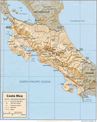
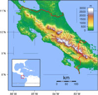
Physical geography
The nation's terrainTerrain
Terrain, or land relief, is the vertical and horizontal dimension of land surface. When relief is described underwater, the term bathymetry is used...
is coastal plain separated by rugged mountains, the Cordillera Central and the Cordillera de Talamanca, which form the spine of the country and separate the Pacific and Caribbean watersheds. Costa Rica claims an exclusive economic zone
Exclusive Economic Zone
Under the law of the sea, an exclusive economic zone is a seazone over which a state has special rights over the exploration and use of marine resources, including production of energy from water and wind. It stretches from the seaward edge of the state's territorial sea out to 200 nautical...
of 200 nmi (370.4 km; 230.2 mi) and a territorial sea
Territorial waters
Territorial waters, or a territorial sea, as defined by the 1982 United Nations Convention on the Law of the Sea, is a belt of coastal waters extending at most from the baseline of a coastal state...
of 12 nmi (22.2 km; 13.8 mi).
The spine of the country produces many major river systems. Rivers draining into the Caribbean include:
- Colorado RiverColorado River (Costa Rica)The Colorado River, or the Rio Colorado, in Costa Rica is a tributary of the San Juan River which flows 96 km towards the Caribbean in the northern parts of Heredia and Limón Provinces...
(Rio Colorado) - Pacuare RiverPacuare RiverThe Pacuare River, or the Río Pacuare, in Costa Rica has its source in the Cordillera de Talamanca and flows approximately 108 km to the Caribbean. It is a popular location for white water rafting, whitewater kayaking and riverboarding...
(Rio Pacuare) - Reventazón RiverReventazón RiverThe Reventazón River or Rio Reventazón, is a river in Costa Rica which forms part of the Reventazón-Parismina drainage basin, it is 145 km long and flows into the Caribbean sea. It rises in Meseta Central and flows through the Orosí, Reventazón and Turrialba Valleys...
(Rio Parismina) - Reventazón RiverReventazón RiverThe Reventazón River or Rio Reventazón, is a river in Costa Rica which forms part of the Reventazón-Parismina drainage basin, it is 145 km long and flows into the Caribbean sea. It rises in Meseta Central and flows through the Orosí, Reventazón and Turrialba Valleys...
(Rio Reventazon) - Sixaola RiverSixaola RiverThe Sixaola River is a river in southern Limón Province, Costa Rica. It flows from the Cordillera Talamanca to the Caribbean Sea northeast of Sixaola at . The river's headwaters are part of the La Amistad International Park. For part of its length, the river forms the border between Limón...
(Rio Sixaola)
Rivers draining into the Lake Nicaragua
Lake Nicaragua
Lake Nicaragua or Cocibolca or Granada or is a vast freshwater lake in Nicaragua of tectonic origin. With an area of , it is the largest lake in Central America, the 19th largest lake in the world and the 9th largest in the Americas. It is slightly smaller than Lake Titicaca. With an elevation...
or the San Juan River
San Juan River (Nicaragua)
The San Juan River , also known as El Desaguadero , is a 192.06 km river that flows east out of Lake Nicaragua into the Caribbean Sea. A large section of the border between Nicaragua and Costa Rica runs on the right bank of the river...
(Rio San Juan), whose waters eventually drains into the Caribbean, include:
- Sapoá River (Rio Sapoá)
- Frío River (Rio Frío)
- San Carlos River (Rio San Carlos)
- Sarapiquí RiverSarapiquí RiverThe Sarapiquí River, or Rio Sarapiquí, in Costa Rica is a tributary of the San Juan River and forms the eastern border of Sarapiquí Canton...
(Rio Sarapiquí)
Rivers draining into the Pacific Ocean include:
- Abangares RiverAbangares RiverAbangares River is a river of Costa Rica....
(Rio Abangares) - Guacimal RiverGuacimal RiverGuacimal River is a river of Costa Rica....
(Rio Guacimal) - Sierpe RiverSierpe River-References:...
(Rio Sierpe) - Tempisque RiverTempisque RiverThe Tempisque River, or Rio Tempisque, is 144 km long, located entirely in Costa Rica flowing from the Guanacaste Cordillera near the Orosí Volcano and emptying into the Gulf of Nicoya...
(Rio Tempisque) - Térraba River (Rio Terraba)
In the eastern half of the country, the San Juan River forms the northern border with Nicaragua
Nicaragua
Nicaragua is the largest country in the Central American American isthmus, bordered by Honduras to the north and Costa Rica to the south. The country is situated between 11 and 14 degrees north of the Equator in the Northern Hemisphere, which places it entirely within the tropics. The Pacific Ocean...
.
Cordillera de Tilarán
The Tilaran Range is part of the Continental DivideContinental Divide
The Continental Divide of the Americas, or merely the Continental Gulf of Division or Great Divide, is the name given to the principal, and largely mountainous, hydrological divide of the Americas that separates the watersheds that drain into the Pacific Ocean from those river systems that drain...
east of Lake Arenal
Lake Arenal
Lake Arenal is an artificial lake in Costa Rica, located in the northern highlands of the country. It was enlarged to its present size as a part of a 1979 hydroelectric project by the Costa Rican government to provide electricity to the country.- Geography :...
and the nearby active volcano Arenal
Arenal Volcano
Arenal Volcano, in Spanish , is an active andesitic stratovolcano in north-western Costa Rica around 90 km northwest of San José, in the province of Alajuela, canton of San Carlos, and district of La Fortuna....
, and running into the Cordillera Central range further east. It is located in the Abangares district of the province of Guanacaste
Guanacaste Province
Guanacaste is a province of Costa Rica located in the northwestern part of the country, along the coast of the Pacific Ocean. To the north it borders Nicaragua. To the east is the Alajuela Province, and to the southeast is the Puntarenas Province. It is the most sparsely populated of all the...
.
At the edge of the range is the Monteverde
Monteverde
Monteverde, Costa Rica is a small town in Puntarenas, Costa Rica. Located in the Cordillera de Tilarán, roughly a four hour drive from the Central Valley of Costa Rica, Monteverde is considered a major ecotourism destination in Costa Rica...
cloud forest preserve, a major ecotourism
Ecotourism
Ecotourism is a form of tourism visiting fragile, pristine, and usually protected areas, intended as a low impact and often small scale alternative to standard commercial tourism...
destination.
Cordillera Central
The Central Range continues the Continental DivideContinental Divide
The Continental Divide of the Americas, or merely the Continental Gulf of Division or Great Divide, is the name given to the principal, and largely mountainous, hydrological divide of the Americas that separates the watersheds that drain into the Pacific Ocean from those river systems that drain...
east of Cordillera de Tilarán. It has four large volcanoes: Poás
Poás Volcano
The Poás Volcano, in Spanish Volcán Poás, is an active stratovolcano in central Costa Rica. Poás has erupted 39 times since 1828.- Crater lakes :...
, Barva
Barva Volcano
Barva Volcano, sometimes called "Las Tres Marías" is an andesitic shield complex in central Costa Rica 22 km north of San José, in the province of Heredia. It sits on the small agricultural community of Sacramento....
, Irazú
Irazú Volcano
The Irazú Volcano is an active volcano in Costa Rica, situated in the Cordillera Central close to the city of Cartago.The name could come from either the combination of "ara" and "tzu" or a corruption of Iztarú, which was the name of an indigenous village on the flanks of the volcano...
and Turrialba
Turrialba Volcano
Turrialba Volcano was named after the region of Costa Rica in which the volcano is situated in Turrialba County, Cartago of Costa Rica. There is no clear consensus on the origin of the name Turrialba, but historians disagree with attempts to attribute the name to the patronym Torrealba or from...
. The highest peak is Irazú at 3,432 m.
Cordillera de Guanacaste
The Guanacaste RangeCordillera de Guanacaste
The Cordillera de Guanacaste, also called Guanacaste Cordillera, are a volcanic mountain range in northern Costa Rica near the border with Nicaragua. The mountain range stretches 110 km from northwest to the southeast and contains mostly complex stratovolcanoes...
is in northern Costa Rica near the border with Nicaragua
Nicaragua
Nicaragua is the largest country in the Central American American isthmus, bordered by Honduras to the north and Costa Rica to the south. The country is situated between 11 and 14 degrees north of the Equator in the Northern Hemisphere, which places it entirely within the tropics. The Pacific Ocean...
. The range forms part of the southern region of the Continental Divide
Continental Divide
The Continental Divide of the Americas, or merely the Continental Gulf of Division or Great Divide, is the name given to the principal, and largely mountainous, hydrological divide of the Americas that separates the watersheds that drain into the Pacific Ocean from those river systems that drain...
, the highest peak being the extinct stratovolcano
Stratovolcano
A stratovolcano, also known as a composite volcano, is a tall, conical volcano built up by many layers of hardened lava, tephra, pumice, and volcanic ash. Unlike shield volcanoes, stratovolcanoes are characterized by a steep profile and periodic, explosive eruptions...
Miravalles
Miravalles Volcano
The Miravalles Volcano is an andesitic stratovolcano in Costa Rica. The caldera was formed during several major explosive eruptions that produced voluminous dacitic-rhyolitic pyroclastic flows between about 1.5 and 0.6 million years ago. The only reported historical eruptive activity was a...
at 2,028 m. Peaks include:
- Miravalles VolcanoMiravalles VolcanoThe Miravalles Volcano is an andesitic stratovolcano in Costa Rica. The caldera was formed during several major explosive eruptions that produced voluminous dacitic-rhyolitic pyroclastic flows between about 1.5 and 0.6 million years ago. The only reported historical eruptive activity was a...
(2,028 m) - Orosí VolcanoOrosí VolcanoThe Orosí Volcano, in Spanish the , is an inactive volcano in Costa Rica, situated in the Cordillera de Guanacaste near the border with Nicaragua...
(1,659 m) - Rincón de la Vieja VolcanoRincón de la Vieja VolcanoRincón de la Vieja is an active andesitic complex volcano in north-western Costa Rica, about 25 km from Liberia, in the province of Guanacaste. Its name means "The Old Woman's Corner", a reference to a local legend about a girl whose lover was thrown into the crater by her father; she became a...
(1,916 m)
Cordillera de Talamanca
Much of the Talamanca RangeCordillera de Talamanca
The Cordillera de Talamanca is a mountain range that lies on the border between Costa Rica and Panama. Much of the range and the area around it is included in the La Amistad International Park, which also is shared between the two countries....
is included in the La Amistad International Park
La Amistad International Park
The La Amistad International Park, or in Spanish , formerly the La Amistad National Park, is an Transboundary Protected Area in Latin America, management of which is shared between Costa Rica and Panama, following a recommendation by UNESCO after the park's inclusion in the World Heritage Site...
, which is shared between Costa Rica and Panama. The country's highest peaks lie in this mountain range: the Cerro Chirripó
Cerro Chirripó
Cerro Chirripó is the highest mountain in Costa Rica, with an altitude of . It is located in the Chirripó National Park and is noted for its ecological wealth. The high peaks in this and La Amistad International Park host important areas of Talamancan montane forest and Costa Rican Páramo with high...
and the Cerro Kamuk
Cerro Kamuk
Cerro Kamuk is a mountain in the core of the foothills and mountains of La Amistad International Park, in the Cordillera de Talamanca, between the mountain ranges of northern Panama and south-eastern Costa Rica. These are the highest and wildest mountains of Central America. The diversity of...
. Much of the region is covered by the forest
Talamancan montane forests
The Talamancan montane forests ecoregion, in the tropical moist broadleaf forest biome, are in montane Costa Rica and Panama in Central America.-Setting:...
.
Cerros de Escazú
The Cerros de EscazúCerros de Escazú
The Cerros de Escazú is a mountain range in central Costa Rica. It borders the Central Valley to the south and is considered the northernmost portion of the Cordillera de Talamanca. The highest peak is Cerro Rabo de Mico with , followed closely by Cerro Cedral with...
borders the Central Valley
Costa Rican Central Valley
The Central Valley is a plateau and a geographic region of central Costa Rica. The land in the valley is a relative plain, despite being surrounded by several mountains and volcanos, the latter part of the Central Range. The region houses almost three quarters of Costa Ricans, and includes the...
to the south and is considered the northernmost portion of the Cordillera de Talamanca.
Volcanoes
- Four volcanoes (two of them active) rise near San JoseSan José, Costa RicaSan José is the capital and largest city of Costa Rica. Located in the Central Valley, San José is the seat of national government, the focal point of political and economic activity, and the major transportation hub of this Central American nation.Founded in 1738 by order of Cabildo de León, San...
, in the center of the country; one of the volcanoes, Irazu VolcanoIrazú VolcanoThe Irazú Volcano is an active volcano in Costa Rica, situated in the Cordillera Central close to the city of Cartago.The name could come from either the combination of "ara" and "tzu" or a corruption of Iztarú, which was the name of an indigenous village on the flanks of the volcano...
, erupted destructively in 1963-1965.
Climate
The country has a tropicalTropics
The tropics is a region of the Earth surrounding the Equator. It is limited in latitude by the Tropic of Cancer in the northern hemisphere at approximately N and the Tropic of Capricorn in the southern hemisphere at S; these latitudes correspond to the axial tilt of the Earth...
and subtropical climate and is part of the Neotropic
Neotropic
In biogeography, the Neotropic or Neotropical zone is one of the eight terrestrial ecozones. This ecozone includes South and Central America, the Mexican lowlands, the Caribbean islands, and southern Florida, because these regions share a large number of plant and animal groups.It is sometimes used...
ecozone
Ecozone
An ecozone is the broadest biogeographic division of the Earth's land surface, based on distributional patterns of terrestrial organisms.Ecozones delineate large areas of the Earth's surface within which organisms have been evolving in relative isolation over long periods of time, separated from...
. It is part of many ecoregion
Ecoregion
An ecoregion , sometimes called a bioregion, is an ecologically and geographically defined area that is smaller than an ecozone and larger than an ecosystem. Ecoregions cover relatively large areas of land or water, and contain characteristic, geographically distinct assemblages of natural...
s, including Costa Rican seasonal moist forests, Bocas del Toro-San Bastimentos Island-San Blas mangroves, Mosquitia-Nicaraguan Caribbean Coast mangroves, Southern Dry Pacific Coast mangroves, Central American dry forests, and Talamancan montane forests. An inlet from the Pacific the Gulf of Nicoya
Gulf of Nicoya
The Gulf of Nicoya is an inlet of the Pacific Ocean. It separates the Nicoya Peninsula from the mainland of Costa Rica, and encompasses a marine and coastal landscape of wetlands, rocky islands and cliffs.-Islands:*Chira Island*Venado Island*Isla Caballo...
contains several small islands, the largest of these being Chira Island
Chira Island
Chira Island is a 3.000 hectare Costa Rican Pacific island located at the upper end of the Gulf of Nicoya, an extensive inlet of sea water that is the result of a geological fault that has caused the land to submerge, leaving exposed only the tops of what were formerly low hills...
with a population of around four thousand.
Costa Rica's dry season in most places is from December to April, while the rainy season is from May to November. On the Caribbean coast, however, December is by far the wettest month. The highlands areas are always cooler. The lowest elevation
Elevation
The elevation of a geographic location is its height above a fixed reference point, most commonly a reference geoid, a mathematical model of the Earth's sea level as an equipotential gravitational surface ....
levels in the country are on the western and eastern coasts, at sea level
Sea level
Mean sea level is a measure of the average height of the ocean's surface ; used as a standard in reckoning land elevation...
. The highest point is Cerro Chirripó
Cerro Chirripó
Cerro Chirripó is the highest mountain in Costa Rica, with an altitude of . It is located in the Chirripó National Park and is noted for its ecological wealth. The high peaks in this and La Amistad International Park host important areas of Talamancan montane forest and Costa Rican Páramo with high...
, a volcanic
Volcano
2. Bedrock3. Conduit 4. Base5. Sill6. Dike7. Layers of ash emitted by the volcano8. Flank| 9. Layers of lava emitted by the volcano10. Throat11. Parasitic cone12. Lava flow13. Vent14. Crater15...
mountain with an elevation of 3810 m (12,500 ft) (part of Chirripó National Park
Chirripó National Park
Chirripó National Park is located in the middle portion of the Talamanca Range of Costa Rica, approximately 30 km northeast from the city of San Isidro del General. It protects a number of important ecosystems on the Costa Rican Pacific slope and is notable for including the largest extension...
). On a clear day, it is possible to see both the Caribbean and the Pacific from the peak.
Ecology
Like all Central American countries, Costa RicaCosta Rica
Costa Rica , officially the Republic of Costa Rica is a multilingual, multiethnic and multicultural country in Central America, bordered by Nicaragua to the north, Panama to the southeast, the Pacific Ocean to the west and the Caribbean Sea to the east....
is considered part of a biodiversity hotspot
Biodiversity hotspot
A biodiversity hotspot is a biogeographic region with a significant reservoir of biodiversity that is under threat from humans.The concept of biodiversity hotspots was originated by Norman Myers in two articles in “The Environmentalist” , revised after thorough analysis by Myers and others in...
. According to the INBio, about 4.5% of the world's biodiversity can be found in Costa Rica.
Costa Rica is home to about 12,119 species of plant
Plant
Plants are living organisms belonging to the kingdom Plantae. Precise definitions of the kingdom vary, but as the term is used here, plants include familiar organisms such as trees, flowers, herbs, bushes, grasses, vines, ferns, mosses, and green algae. The group is also called green plants or...
s, of which 950 are endemic. There are 117 native trees and more than 1,400 types of orchids, a third of them can be found in the Monteverde Cloud Forest Reserve. Almost a half of the country's land is covered by forests, though only 3.5% is covered by primary forests. Deforestation
Deforestation in Costa Rica
Deforestation is a major threat to biodiversity and ecosystems in Costa Rica. The country has a rich biodiversity with some 12,000 species of plants, 1,239 species of butterflies, 838 species of birds, 440 species of reptiles and amphibians, and 232 species of mammals, which have been under threat...
is a devastating process, with more than 8,100 ha of forest being lost annually. The main reason for such high deforestation levels is to make plains for cattle ranching.
Wildlife diversity
Wildlife of Costa Rica
Costa Rica supports an enormous variety of wildlife, due in large part to its geographic position between the North and South American continents, its neotropical climate, and its wide variety of habitats...
is very high; there are 441 species of amphibian
Amphibian
Amphibians , are a class of vertebrate animals including animals such as toads, frogs, caecilians, and salamanders. They are characterized as non-amniote ectothermic tetrapods...
s and reptile
Reptile
Reptiles are members of a class of air-breathing, ectothermic vertebrates which are characterized by laying shelled eggs , and having skin covered in scales and/or scutes. They are tetrapods, either having four limbs or being descended from four-limbed ancestors...
s, 838 species of bird
Bird
Birds are feathered, winged, bipedal, endothermic , egg-laying, vertebrate animals. Around 10,000 living species and 188 families makes them the most speciose class of tetrapod vertebrates. They inhabit ecosystems across the globe, from the Arctic to the Antarctic. Extant birds range in size from...
s, 232 species of mammals and 181 species of fresh water fish. Costa Rica has high levels of endemism; 81 species of amphibians and reptiles, 17 species of birds and 7 species of mammals are endemic to the country. However, many species are endangered. According to the World Conservation Monitoring Centre
World Conservation Monitoring Centre
The United Nations Environment Programme's World Conservation Monitoring Centre is an executive agency of the United Nations Environment Programme, based in Cambridge in the United Kingdom. UNEP-WCMC has been part of UNEP since 2000, and has responsibility for biodiversity assessment and support...
, 209 species of birds, mammals, reptiles, amphibians and plants are endangered. Some of the country's most endangered species are the Harpy eagle, the Giant anteater
Giant Anteater
The Giant Anteater, Myrmecophaga tridactyla, is the largest species of anteater. It is the only species in the genus Myrmecophaga. It is found in Central and South America from Honduras to northern Argentina...
, the Golden toad
Golden toad
The golden toad was a small, shiny, bright true toad that was once abundant in a small region of high-altitude cloud-covered tropical forests, about 30 square kilometers in area, above the city of Monteverde, Costa Rica. For this reason, it is sometimes also called the Monteverde golden toad, or...
and the Jaguar
Jaguar
The jaguar is a big cat, a feline in the Panthera genus, and is the only Panthera species found in the Americas. The jaguar is the third-largest feline after the tiger and the lion, and the largest in the Western Hemisphere. The jaguar's present range extends from Southern United States and Mexico...
. IUCN reports the Golden toad
Golden toad
The golden toad was a small, shiny, bright true toad that was once abundant in a small region of high-altitude cloud-covered tropical forests, about 30 square kilometers in area, above the city of Monteverde, Costa Rica. For this reason, it is sometimes also called the Monteverde golden toad, or...
as extinct.
Protected areas
The country is noted for its national park systemNational Parks of Costa Rica
There are currently 26 National Parks of Costa Rica, which are managed under the umbrella of SINAC , a department of Costa Rica's Ministry of Environment and Energy ....
, administered by SINAC
SINAC
SINAC the National System of Conservation Areas, or in Spanish the , is the Costa Rican National Parks administrator, and is part of the Ministry of Environment and Energy or MINAE...
(Sistema Nacional de Areas de Conservacion, or "National System of Conservation Areas"). This agency oversees the 26 national park
National park
A national park is a reserve of natural, semi-natural, or developed land that a sovereign state declares or owns. Although individual nations designate their own national parks differently A national park is a reserve of natural, semi-natural, or developed land that a sovereign state declares or...
, and more than 160 protected areas in Costa Rica. The other types of protected areas in Costa Rica are National Wildlife Refuges, Biological Reserves, Protection Zones, and Absolute Nature Reserves. Together the protected areas comprise over one-fourth of Costa Rican territory. 9.3% of the country is protected under IUCN categories I-V.
Tortuguero National Park
The creation of the Tortuguero National ParkTortuguero National Park
Tortuguero National Park is a National Park within the Tortuguero Conservation Area. The reserve is also included in the Humedal Caribe Noreste, a wetland of international importance under the Ramsar Convention. The park is located in the Limón Province of northeastern Costa Rica...
in 1970 gave much needed protection to one of the region's most important and unique natural resources: a 22 km stretch of shoreline that serves as the principal nesting site for sea turtles.
International law
Costa Rica is party to many environmental treaties, including the Convention on Biological DiversityConvention on Biological Diversity
The Convention on Biological Diversity , known informally as the Biodiversity Convention, is an international legally binding treaty...
, the Convention on Environmental Modification, the United Nations Framework Convention on Climate Change
United Nations Framework Convention on Climate Change
The United Nations Framework Convention on Climate Change is an international environmental treaty produced at the United Nations Conference on Environment and Development , informally known as the Earth Summit, held in Rio de Janeiro from June 3 to 14, 1992...
, the Montreal Protocol
Montreal Protocol
The Montreal Protocol on Substances That Deplete the Ozone Layer is an international treaty designed to protect the ozone layer by phasing out the production of numerous substances believed to be responsible for ozone depletion...
, the Ramsar Convention
Ramsar Convention
The Ramsar Convention is an international treaty for the conservation and sustainable utilization of wetlands, i.e., to stem the progressive encroachment on and loss of wetlands now and in the future, recognizing the fundamental ecological functions of wetlands and their economic, cultural,...
, the International Convention for the Regulation of Whaling
International Convention for the Regulation of Whaling
The International Convention for the Regulation of Whaling is an international environmental agreement signed in 1946 in order to "provide for the proper conservation of whale stocks and thus make possible the orderly development of the whaling industry"...
, the Desertification Convention
United Nations Convention to Combat Desertification
The United Nations Convention to Combat Desertification in Those Countries Experiencing Serious Drought and/or Desertification, Particularly in Africa is a Convention to combat desertification and mitigate the effects of drought through national action programs that incorporate long-term strategies...
, the Endangered Species Convention
Convention on the International Trade in Endangered Species of Wild Flora and Fauna
CITES is a multilateral treaty, drafted as a result of a resolution adopted in 1963 at a meeting of members of the International Union for Conservation of Nature...
, the Basel Convention
Basel Convention
The Basel Convention on the Control of Transboundary Movements of Hazardous Wastes and Their Disposal, usually known simply as the Basel Convention, is an international treaty that was designed to reduce the movements of hazardous waste between nations, and specifically to prevent transfer of...
, the Convention on the Law of the Sea
United Nations Convention on the Law of the Sea
The United Nations Convention on the Law of the Sea , also called the Law of the Sea Convention or the Law of the Sea treaty, is the international agreement that resulted from the third United Nations Conference on the Law of the Sea , which took place from 1973 through 1982...
, the Convention on Marine Dumping, the Comprehensive Test Ban Treaty
Comprehensive Test Ban Treaty
The Comprehensive Nuclear-Test-Ban Treaty bans all nuclear explosions in all environments, for military or civilian purposes. It was adopted by the United Nations General Assembly on 10 September 1996 but it has not entered into force.-Status:...
. It has signed but not ratified the Convention on Marine Life Conservation
Convention on Fishing and Conservation of Living Resources of the High Seas
The Convention on Fishing and Conservation of Living Resources of the High Seas is an agreement that was designed to solve through international cooperation the problems involved in the conservation of living resources of the high seas, considering that because of the development of modern...
and the Kyoto Protocol
Kyoto Protocol
The Kyoto Protocol is a protocol to the United Nations Framework Convention on Climate Change , aimed at fighting global warming...
.
Central America gained independence from Spain on September 15, 1820.
Maritime claims
- Territorial sea: 12 nmi (22.2 km; 13.8 mi)
- Exclusive Economic Zone: 200 nmi (370.4 km; 230.2 mi)
- Continental shelf: 200 nmi (370.4 km; 230.2 mi)
Climate
- Tropical and subtropical; dry season (December to April); rainy season (May to November); cooler in highlands
Terrain
- Coastal plains separated by rugged mountains including over 100 volcanic cones, of which several are major volcanoes.
Natural hazards
- Occasional earthquakeEarthquakeAn earthquake is the result of a sudden release of energy in the Earth's crust that creates seismic waves. The seismicity, seismism or seismic activity of an area refers to the frequency, type and size of earthquakes experienced over a period of time...
s, hurricanes along Atlantic coast; frequent floodFloodA flood is an overflow of an expanse of water that submerges land. The EU Floods directive defines a flood as a temporary covering by water of land not normally covered by water...
ing of lowlands at onset of rainy season and landslideLandslideA landslide or landslip is a geological phenomenon which includes a wide range of ground movement, such as rockfalls, deep failure of slopes and shallow debris flows, which can occur in offshore, coastal and onshore environments...
s; active volcanoVolcano2. Bedrock3. Conduit 4. Base5. Sill6. Dike7. Layers of ash emitted by the volcano8. Flank| 9. Layers of lava emitted by the volcano10. Throat11. Parasitic cone12. Lava flow13. Vent14. Crater15...
es (See Climate of Costa RicaClimate of Costa RicaBecause Costa Rica is located only about eight degrees north of the equator, the climate is tropical year round. However, this varies depending on elevation and rainfall. Therefore, it is greatly affected by the geography of Costa Rica....
).
Environment
- DeforestationDeforestationDeforestation is the removal of a forest or stand of trees where the land is thereafter converted to a nonforest use. Examples of deforestation include conversion of forestland to farms, ranches, or urban use....
, largely a result of the clearing of land for cattle ranching; soil erosionErosionErosion is when materials are removed from the surface and changed into something else. It only works by hydraulic actions and transport of solids in the natural environment, and leads to the deposition of these materials elsewhere...
; coastal marine pollutionPollutionPollution is the introduction of contaminants into a natural environment that causes instability, disorder, harm or discomfort to the ecosystem i.e. physical systems or living organisms. Pollution can take the form of chemical substances or energy, such as noise, heat or light...
; fisheries protection; solid waste management; air pollution
See also
- Costa RicaCosta RicaCosta Rica , officially the Republic of Costa Rica is a multilingual, multiethnic and multicultural country in Central America, bordered by Nicaragua to the north, Panama to the southeast, the Pacific Ocean to the west and the Caribbean Sea to the east....
- Climate of Costa RicaClimate of Costa RicaBecause Costa Rica is located only about eight degrees north of the equator, the climate is tropical year round. However, this varies depending on elevation and rainfall. Therefore, it is greatly affected by the geography of Costa Rica....
- List of earthquakes in Costa Rica
- List of Faults in Costa Rica