
Guanacaste Province
Encyclopedia
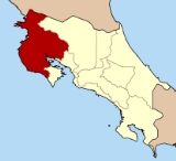
Guanacaste is a province
of Costa Rica
located in the northwestern part of the country, along the coast of the Pacific Ocean
. To the north it borders Nicaragua
. To the east is the Alajuela Province
, and to the southeast is the Puntarenas Province
. It is the most sparsely populated of all the provinces of Costa Rica. The province covers an area of 10141 km² (3,915.5 sq mi) and as of 2000, had a population of 264,238.
Guanacaste's capital is Liberia
. Other important cities include Cañas
and Nicoya
.
.
arrived, ths territory was inhabited by Chorotega
Indians from the town of Zapati, Nacaome, Paro, Cangel, Nicopasaya, Pocosí, Diriá
, Papagayo, Namiapí and Orosi
. The Corobicies lived on the eastern shore of the Gulf of Nicoya and the Nahuas or Aztecan in the zone of Bagaces
.
The first church was built out of straw in Nicoya
in the 17th Century.
In the 18th Century some neighbors of Rivas established their houses and cattle farms in the northern part of the Nicoya Peninsula at crossroads that connected the towns of Bagaces, Nicoya and Rivas. The place was baptized after a famous Guanacaste tree that grows in the neighborhood.
Part of the Nicaraguan territory prior to independence from Spain, but in 1824-25 the territory of Guanacaste was annexed to Costa Rica
. The inhabitants decided by their own will to be part of Costa Rica
. The 25th of July 1824 the town people of Nicoya and Santa Cruz decided to join Costa Rica
. In 1836 the town of Guanacaste was declared capital of Guanacaste province. In 1854 the town of Guanacaste was renamed Liberia
.
 The province is bounded on the east by a group of green-swathed volcanoes forming the Cordillera de Guanacaste
and the Cordillera de Tilaran. The rivers that tumble out of these steep mountains flow down to rolling flatlands, forming a vast alluvial plain drained by the Rio Tempisque, which empties through swampy wetlands into de Golfo de Nicoya. The Rio Tempisque defines one side of the horsehead-shaped Peninsula de Nicoya enclosing the gulf to the west.
The province is heavily forested in parts.
and consistent heat from November to April. Tourists seek out this dry heat during the North America
n winter to enjoy the breathtaking Guanacastecan beaches. Irrigation of the agricultural land is necessary during the long dry season.
From May to October, the climate is similar to that of San José
, consisting of showers daily and moderate temperatures. Guanacaste is, however, considerably warmer than provinces residing in higher elevations.
natives and Spaniard
s. As in Nicaragua and elsewhere in Costa Rica, Usted is the form of address used by Guanacastecans upon initial meetings, but once they have established a friendship, they switch to the vos
verb-form.
The Chorotega culture and the Spanish
culture have successfully integrated; among the main cultural elements are their music, literature (folklore), musical instruments, bullfighting, and religious events.
and related breeds graze.
Historically, the main source of income of Guanacaste was cattle ranching. Cattle ranching is declining in Guanacaste due to an international drop in the demand for beef
. Many pastures are naturally reverting back to dry forest or are being converted to tree plantations.
The other agricultural products of relative importance in the province are sugar cane and cotton, and since the late 1980s, with the creation of a large-scale irrigation program (the water comes from Lake Arenal
after passing through several power generating stations), rice has become a prominent crop.
Today tourism has emerged as the new and growing activity in the local economy. The combination of beautiful beaches like Playa Tamarindo
and the sun-drenched dry season that coincides with the winter months in northern latitudes have made tourism the most lucrative revenue.
A lot of tourist are also attracted by the abundance of natural beauty. The Province has no less than seven national parks like Santa Rosa
, Guanacaste
and Rincon de la Vieja National Park.
. The cantons (with their capitals in parentheses) are:
A major portion of the peninsula of Nicoya is now under the jurisdiction of the province of Puntarenas
. This may change in the future, as there is constant debate over the remapping of the area.
Provinces of Costa Rica
Costa Rica consists of 7 provinces :The provinces are further divided into cantons , which are subdivided into districts .-See also:* ISO 3166-2:CR* Cantons of Costa Rica* Districts of Costa Rica...
of Costa Rica
Costa Rica
Costa Rica , officially the Republic of Costa Rica is a multilingual, multiethnic and multicultural country in Central America, bordered by Nicaragua to the north, Panama to the southeast, the Pacific Ocean to the west and the Caribbean Sea to the east....
located in the northwestern part of the country, along the coast of the Pacific Ocean
Pacific Ocean
The Pacific Ocean is the largest of the Earth's oceanic divisions. It extends from the Arctic in the north to the Southern Ocean in the south, bounded by Asia and Australia in the west, and the Americas in the east.At 165.2 million square kilometres in area, this largest division of the World...
. To the north it borders Nicaragua
Nicaragua
Nicaragua is the largest country in the Central American American isthmus, bordered by Honduras to the north and Costa Rica to the south. The country is situated between 11 and 14 degrees north of the Equator in the Northern Hemisphere, which places it entirely within the tropics. The Pacific Ocean...
. To the east is the Alajuela Province
Alajuela Province
Alajuela is a province of Costa Rica. It is located in the north-central part of the country, bordering Nicaragua to the north, and clockwise the provinces Heredia, San José, Puntarenas and Guanacaste...
, and to the southeast is the Puntarenas Province
Puntarenas Province
Puntarenas is a province of Costa Rica. It is located in the western part of the country, covering most of Costa Rica's Pacific Ocean coast, and it is the largest province in Costa Rica. Clockwise from the northwest it borders on the provinces Guanacaste, Alajuela, San José and Limón, and the...
. It is the most sparsely populated of all the provinces of Costa Rica. The province covers an area of 10141 km² (3,915.5 sq mi) and as of 2000, had a population of 264,238.
Guanacaste's capital is Liberia
Liberia, Costa Rica
Liberia is the capital and largest city of Guanacaste province, Costa Rica, located northwest of the national capital, San José.-Summary:With more than 35,000 inhabitants, Liberia is the regional hub of the Costa Rican northwest. The city center features a modern church, as many Costa Rican towns...
. Other important cities include Cañas
Canas
Canas or Cañas may refer to:People:* Alberto Cañas Escalante, Costa Rican politician* Antonio José Cañas, Salvadoran military officer, diplomat and politician* Carlos Cañas, Salvadoran painter...
and Nicoya
Nicoya
Nicoya is a town in Costa Rica's Guanacaste province, and one of its most important tourist zones. It serves as a transport hub to Guanacaste's beaches and national parks. According to the 2000 census, the city's population was 13,334—second only to Liberia in the province...
.
Etymology
The province is named for the guanacaste tree, also known as the ear pod tree which is the national tree of Costa RicaCosta Rica
Costa Rica , officially the Republic of Costa Rica is a multilingual, multiethnic and multicultural country in Central America, bordered by Nicaragua to the north, Panama to the southeast, the Pacific Ocean to the west and the Caribbean Sea to the east....
.
History
Before the SpanishSpanish people
The Spanish are citizens of the Kingdom of Spain. Within Spain, there are also a number of vigorous nationalisms and regionalisms, reflecting the country's complex history....
arrived, ths territory was inhabited by Chorotega
Chorotega
Chorotega, also known as Mangue, was a language indigenous people of Honduras, Costa Rica and Nicaragua. The ethnic population number around 10,000. The Chorotega language, which was a member of the Manguean branch of the Oto-Manguean language family, is now extinct...
Indians from the town of Zapati, Nacaome, Paro, Cangel, Nicopasaya, Pocosí, Diriá
Diria
Diria is a municipality in the Granada department of Nicaragua....
, Papagayo, Namiapí and Orosi
Orosi
- Geography :* Orosí, Costa Rica* Orosí Volcano in Costa Rica* Orosi, California in the USA...
. The Corobicies lived on the eastern shore of the Gulf of Nicoya and the Nahuas or Aztecan in the zone of Bagaces
Bagaces
Bagaces is a town in Bagaces Canton, in the Guanacaste Province of Costa Rica. It is the administrative seat of Bagaces District. The town lies along the Pan-American Highway.-External links:* Maplandia...
.
The first church was built out of straw in Nicoya
Nicoya
Nicoya is a town in Costa Rica's Guanacaste province, and one of its most important tourist zones. It serves as a transport hub to Guanacaste's beaches and national parks. According to the 2000 census, the city's population was 13,334—second only to Liberia in the province...
in the 17th Century.
In the 18th Century some neighbors of Rivas established their houses and cattle farms in the northern part of the Nicoya Peninsula at crossroads that connected the towns of Bagaces, Nicoya and Rivas. The place was baptized after a famous Guanacaste tree that grows in the neighborhood.
Part of the Nicaraguan territory prior to independence from Spain, but in 1824-25 the territory of Guanacaste was annexed to Costa Rica
Costa Rica
Costa Rica , officially the Republic of Costa Rica is a multilingual, multiethnic and multicultural country in Central America, bordered by Nicaragua to the north, Panama to the southeast, the Pacific Ocean to the west and the Caribbean Sea to the east....
. The inhabitants decided by their own will to be part of Costa Rica
Costa Rica
Costa Rica , officially the Republic of Costa Rica is a multilingual, multiethnic and multicultural country in Central America, bordered by Nicaragua to the north, Panama to the southeast, the Pacific Ocean to the west and the Caribbean Sea to the east....
. The 25th of July 1824 the town people of Nicoya and Santa Cruz decided to join Costa Rica
Costa Rica
Costa Rica , officially the Republic of Costa Rica is a multilingual, multiethnic and multicultural country in Central America, bordered by Nicaragua to the north, Panama to the southeast, the Pacific Ocean to the west and the Caribbean Sea to the east....
. In 1836 the town of Guanacaste was declared capital of Guanacaste province. In 1854 the town of Guanacaste was renamed Liberia
Liberia, Costa Rica
Liberia is the capital and largest city of Guanacaste province, Costa Rica, located northwest of the national capital, San José.-Summary:With more than 35,000 inhabitants, Liberia is the regional hub of the Costa Rican northwest. The city center features a modern church, as many Costa Rican towns...
.
Geography
Cordillera de Guanacaste
The Cordillera de Guanacaste, also called Guanacaste Cordillera, are a volcanic mountain range in northern Costa Rica near the border with Nicaragua. The mountain range stretches 110 km from northwest to the southeast and contains mostly complex stratovolcanoes...
and the Cordillera de Tilaran. The rivers that tumble out of these steep mountains flow down to rolling flatlands, forming a vast alluvial plain drained by the Rio Tempisque, which empties through swampy wetlands into de Golfo de Nicoya. The Rio Tempisque defines one side of the horsehead-shaped Peninsula de Nicoya enclosing the gulf to the west.
The province is heavily forested in parts.
Climate
Guanacaste's climate and culture are unique among Costa Rican provinces. The province experiences little rainRain
Rain is liquid precipitation, as opposed to non-liquid kinds of precipitation such as snow, hail and sleet. Rain requires the presence of a thick layer of the atmosphere to have temperatures above the melting point of water near and above the Earth's surface...
and consistent heat from November to April. Tourists seek out this dry heat during the North America
North America
North America is a continent wholly within the Northern Hemisphere and almost wholly within the Western Hemisphere. It is also considered a northern subcontinent of the Americas...
n winter to enjoy the breathtaking Guanacastecan beaches. Irrigation of the agricultural land is necessary during the long dry season.
From May to October, the climate is similar to that of San José
San José, Costa Rica
San José is the capital and largest city of Costa Rica. Located in the Central Valley, San José is the seat of national government, the focal point of political and economic activity, and the major transportation hub of this Central American nation.Founded in 1738 by order of Cabildo de León, San...
, consisting of showers daily and moderate temperatures. Guanacaste is, however, considerably warmer than provinces residing in higher elevations.
Demography
Most of the population descends from a mix of ChorotegaChorotega
Chorotega, also known as Mangue, was a language indigenous people of Honduras, Costa Rica and Nicaragua. The ethnic population number around 10,000. The Chorotega language, which was a member of the Manguean branch of the Oto-Manguean language family, is now extinct...
natives and Spaniard
Spanish people
The Spanish are citizens of the Kingdom of Spain. Within Spain, there are also a number of vigorous nationalisms and regionalisms, reflecting the country's complex history....
s. As in Nicaragua and elsewhere in Costa Rica, Usted is the form of address used by Guanacastecans upon initial meetings, but once they have established a friendship, they switch to the vos
Voseo
Voseo is the use of the second person singular pronoun vos in many dialects of Spanish. In dialects that have it, it is used either instead of tú, or alongside it....
verb-form.
The Chorotega culture and the Spanish
Spanish people
The Spanish are citizens of the Kingdom of Spain. Within Spain, there are also a number of vigorous nationalisms and regionalisms, reflecting the country's complex history....
culture have successfully integrated; among the main cultural elements are their music, literature (folklore), musical instruments, bullfighting, and religious events.
Economy
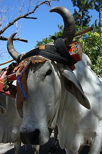
The province has an economic and cultural heritage based on beef cattle ranching. Most of the area is covered by small patches of forest, scattered trees and large pastures of coarse grasses where Brahman cattleBrahman (cattle)
The Brahman or Brahma is a breed of Zebu cattle , later exported from India to the rest of the world. The main breeds used were Kankrej, Gujurat, Nelore or Ongole and the Gir or Gyr cattle...
and related breeds graze.
Historically, the main source of income of Guanacaste was cattle ranching. Cattle ranching is declining in Guanacaste due to an international drop in the demand for beef
Beef
Beef is the culinary name for meat from bovines, especially domestic cattle. Beef can be harvested from cows, bulls, heifers or steers. It is one of the principal meats used in the cuisine of the Middle East , Australia, Argentina, Brazil, Europe and the United States, and is also important in...
. Many pastures are naturally reverting back to dry forest or are being converted to tree plantations.
The other agricultural products of relative importance in the province are sugar cane and cotton, and since the late 1980s, with the creation of a large-scale irrigation program (the water comes from Lake Arenal
Lake Arenal
Lake Arenal is an artificial lake in Costa Rica, located in the northern highlands of the country. It was enlarged to its present size as a part of a 1979 hydroelectric project by the Costa Rican government to provide electricity to the country.- Geography :...
after passing through several power generating stations), rice has become a prominent crop.
Today tourism has emerged as the new and growing activity in the local economy. The combination of beautiful beaches like Playa Tamarindo
Tamarindo, Costa Rica
Tamarindo is a town and distrito located on the Northern Pacific coast of Costa Rica in the Province of Guanacaste. The district has a population of 3,525, although the town itself is about 500. But it can swell to 5,000 people or more during the tourist season and during special holidays...
and the sun-drenched dry season that coincides with the winter months in northern latitudes have made tourism the most lucrative revenue.
A lot of tourist are also attracted by the abundance of natural beauty. The Province has no less than seven national parks like Santa Rosa
Santa Rosa National Park
Santa Rosa National Park, in Spanish the , is a national park, part of the Area de Conservación Guanacaste World Heritage site, in the northern western part of Costa Rica, originally created to protect the scene of the Battle of Santa Rosa, at its eastern edge lies the Interamerican Highway where...
, Guanacaste
Guanacaste National Park (Costa Rica)
Guanacaste National Park, in Spanish , is part of the Area de Conservación Guanacaste World Heritage Site, is a National Park in the northern part of Costa Rica, from the slopes of the Orosí and Cacao volcanoes west to the Interamerican Highway where it is adjacent to the Santa Rosa National Park....
and Rincon de la Vieja National Park.
Political divisions
Guanacaste is subdivided into eleven cantonsCanton (subnational entity)
A canton is a type of administrative division of a country. In general, cantons are relatively small in terms of area and population when compared to other administrative divisions such as counties, departments or provinces. Internationally the best-known cantons, and the most politically...
. The cantons (with their capitals in parentheses) are:
- LiberiaLiberia CantonLiberia is the first canton in the province of Guanacaste in Costa Rica. The canton covers an area of 1,436.47 km², and has a population of 50,359. Its capital is the provincial capital city of Liberia....
(LiberiaLiberia, Costa RicaLiberia is the capital and largest city of Guanacaste province, Costa Rica, located northwest of the national capital, San José.-Summary:With more than 35,000 inhabitants, Liberia is the regional hub of the Costa Rican northwest. The city center features a modern church, as many Costa Rican towns...
) - NicoyaNicoya CantonNicoya is the second canton in the province of Guanacaste in Costa Rica. The canton covers an area of 1,333.68 km², and has a population of 44,834...
(NicoyaNicoyaNicoya is a town in Costa Rica's Guanacaste province, and one of its most important tourist zones. It serves as a transport hub to Guanacaste's beaches and national parks. According to the 2000 census, the city's population was 13,334—second only to Liberia in the province...
) - Santa Cruz (Santa Cruz)
- BagacesBagaces CantonBagaces is the fourth canton in the province of Guanacaste in Costa Rica. The canton covers an area of 1,273.49 km², and has a population of 17,087. Its capital city is also called Bagaces....
(BagacesBagacesBagaces is a town in Bagaces Canton, in the Guanacaste Province of Costa Rica. It is the administrative seat of Bagaces District. The town lies along the Pan-American Highway.-External links:* Maplandia...
) - CarrilloCarrillo CantonCarrillo is the fifth canton in the province of Guanacaste in Costa Rica. The canton covers an area of 577.54 km², and has a population of 29,298. Its capital city is Filadelfia. The name of the canton is in honor of former head of state Braulio Carrillo Colina.The canton is shaped like a...
(FiladelfiaFiladelfia de GuanacasteFiladelfia is the first district and main city of Carrillo in Guanacaste, Costa Rica. This district has 7,814 inhabitants and 125.01 km². It was declared an archaeological city because of all the indigenous cemeteries found near the Tempisque River. The town was formerly known as Siete Cueros...
) - CañasCañas CantonCañas is the sixth canton in the province of Guanacaste in Costa Rica. The canton covers an area of 682.20 km², and has a population of 25,897. Its capital city is also called Cañas.The elongated canton touches the Río Tempisque in the southwest...
(Cañas) - AbangaresAbangaresAbangares is the seventh canton in the province of Guanacaste in Costa Rica. The canton covers an area of 675.76 km² , and has a population of 17,289. Its capital city is Las Juntas....
(Las Juntas) - TilaránTilarán CantonTilarán is the eighth canton in the province of Guanacaste in Costa Rica. The canton covers an area of 638.39 km², and has a population of 19,045. Its capital city is also called Tilarán....
(TilaránTilaránTilarán is a small town in the Guanacaste Province, Costa Rica. It is the seat of the Tilarán Canton located in the hills overlooking the west shore of Lake Arenal...
) - Nandayure (Carmona)
- La CruzLa Cruz CantonLa Cruz is the tenth canton in the province of Guanacaste in Costa Rica. The canton covers an area of 1,383.90 km², and has a population of 18,004. Its capital city is also called La Cruz.The canton is the northernmost in the country...
(La CruzLa Cruz de GuanacasteLa Cruz is the tenth canton of Guanacaste province in Costa Rica, established since 1969. La Cruz bounded on the north with Nicaragua and is where the main border crossing is . La Cruz is located on the shores of what is known as the viewpoint La Cruz...
) - HojanchaHojancha CantonHojancha is the 11th canton in the province of Guanacaste in Costa Rica. The canton covers an area of 261.42 km², and has a population of 6,960. Its capital city is also called Hojancha.The canton is in the midsection of the Nicoya Peninsula...
(Hojancha)
A major portion of the peninsula of Nicoya is now under the jurisdiction of the province of Puntarenas
Puntarenas Province
Puntarenas is a province of Costa Rica. It is located in the western part of the country, covering most of Costa Rica's Pacific Ocean coast, and it is the largest province in Costa Rica. Clockwise from the northwest it borders on the provinces Guanacaste, Alajuela, San José and Limón, and the...
. This may change in the future, as there is constant debate over the remapping of the area.
External links
- El Área de Conservación Guanacaste
- Interesting articles and abundant tourist information about Guanacaste
- A place to enjoy and learn about Guanacaste culture, traditions, the Guanacaste tree, the tropical dry forest, the flora and fauna (all environment-friendly managed).
- Informational source for the province of Guanacaste