

Earth's magnetic field
Encyclopedia
Earth's magnetic field (also known as the geomagnetic field) is the magnetic field that extends from the Earth's inner core
to where it meets the solar wind
, a stream of energetic particles emanating from the Sun
. It is approximately the field of a magnetic dipole
tilted at an angle of 11 degrees with respect to the rotational axis—as if there were a bar magnet placed at that angle at the center of the Earth. However, unlike the field of a bar magnet, Earth's field changes over time because it is really generated by the motion of molten iron alloys in the Earth's outer core
(the geodynamo). The Magnetic North Pole wanders, fortunately slowly enough that the compass
is useful for navigation. At random intervals (averaging several hundred thousand years) the Earth's field reverses (the north and south geomagnetic pole
s change places with each other). These reversals leave a record in rocks that allow paleomagnetists
to calculate past motions of continents and ocean floors as a result of plate tectonics
. The region above the ionosphere
, and extending several tens of thousands of kilometers into space
, is called the magnetosphere
. This region protects the Earth from harmful ultraviolet radiation and cosmic rays
.
The Earth is largely protected from the solar wind
, a stream of energetic charged particles emanating from the Sun
, by its magnetic field, which deflects most of the charged particles. These particles would strip away the ozone layer
, which protects the Earth from harmful ultraviolet
rays. Calculations of the loss of carbon dioxide from the atmosphere of Mars, resulting from scavenging of ions by the solar wind, are consistent with a near-total loss of its atmosphere since the magnetic field of Mars turned off.
The Earth's field is recorded in rocks. Reversals of the field have left a series of stripes on the seafloor that made it possible to time seafloor spreading
, while the steadiness of the geomagnetic pole
s in between reversals allow paleomagnetists
to track the motion of continents in the past. Reversals also provide the basis for magnetostratigraphy
, a way of dating
rocks and sediments. The field also magnetizes the crust; magnetic anomalies can be used to search for ores
.
positioned at the center of the Earth and tilted at an angle of about with respect to the rotational axis of the Earth. The dipole is roughly equivalent to a powerful bar magnet
, with its south pole pointing towards the geomagnetic North Pole
. This may seem surprising, but the north pole of a magnet is so defined because it is attracted towards the Earth's north pole. Since the north pole of a magnet attracts the south poles of other magnets and repels the north poles, it must be attracted to the south pole of Earth's magnet. The dipolar field accounts for of the field in most locations.
, with . It ranges from about nT, or gauss. By comparison, a strong refrigerator magnet has a field of about 100 gauss. As can be seen in the figure, the minimum occurs over South America while there are maxima over northern Canada, Siberia, and the coast of Antarctica south of Australia.
and rotates upwards as the latitude decreases until it is horizontal at the magnetic equator. It continues to rotate upwards until it is straight up at the South Magnetic Pole
. Inclination can be measured with a dip circle
.
. Maps typically include information on the declination as an angle or a small diagram showing the relationship between magnetic north and true north. Information on declination for a region can be represented by a chart with isogonic lines (contour lines with each line representing a fixed declination).
Often, a magnetic (dip) pole is viewed as a point on the Earth's surface where the magnetic field
is entirely vertical. Another way of saying this is that the inclination
of the Earth's field is at the North Magnetic Pole and at the South Magnetic Pole. The two poles wander independently of each other and are not at directly opposite positions on the globe. They can migrate rapidly: movements of up to km per year have been observed for the North Magnetic Pole. The magnetic equator is the line where the inclination is zero (the magnetic field is horizontal).
If a line is drawn parallel to the moment of the best-fitting magnetic dipole, the two positions where it intersects the Earth's surface are called the North and South geomagnetic pole
s. If the Earth's magnetic field were perfectly dipolar, the geomagnetic and magnetic dip poles would coincide and compasses would point towards them. However, the Earth's field has a significant contribution from non-dipolar terms
, so the poles do not coincide and compasses do not generally point at either.
. A smaller number of particles from the solar wind manage to travel, as though on an electromagnetic energy transmission line, to the Earth's upper atmosphere and ionosphere
in the auroral zones. The only time the solar wind is observable on the Earth is when it is strong enough to produce phenomena such as the aurora
and geomagnetic storm
s. Bright auroras strongly heat the ionosphere, causing its plasma to expand into the magnetosphere
, increasing the size of the plasma geosphere
, and causing escape of atmospheric matter into the solar wind. Geomagnetic storm
s result when the pressure of plasmas contained inside the magnetosphere is sufficiently large to inflate and thereby distort the geomagnetic field.
The solar wind is responsible for the overall shape of Earth's magnetosphere, and fluctuations in its speed, density, direction, and entrained magnetic field strongly affect Earth's local space environment. For example, the levels of ionizing radiation and radio interference can vary by factors of hundreds to thousands; and the shape and location of the magnetopause and bow shock wave
upstream of it can change by several Earth radii, exposing geosynchronous satellites to the direct solar wind. These phenomena are collectively called space weather
. The mechanism of atmospheric stripping is caused by gas being caught in bubbles of magnetic field, which are ripped off by solar winds. Variations in the magnetic field strength have been correlated to rainfall variation within the tropics
.
and magnetosphere
, and some changes can be traced to geomagnetic storms or daily variations in currents. Changes over time scales of a year or more mostly reflect changes in the Earth's interior, particularly the iron-rich core
.
Frequently, the Earth's magnetosphere
is hit by solar flare
s causing geomagnetic storm
s, provoking displays of aurorae
. The short-term instability of the magnetic field is measured with the K-index
.
Data from THEMIS
show that the magnetic field, which interacts with the solar wind
, is reduced when the magnetic orientation is aligned between Sun and Earth - opposite to the previous hypothesis. During forthcoming solar storms
, this could result in blackout
s and disruptions in artificial satellites.
 Changes in Earth's magnetic field on a time scale of a year or more are referred to as secular variation. Over hundreds of years, magnetic declination
is observed to vary over tens of degrees. A movie on the right shows how global declinations have changed over the last few centuries.
The direction and intensity of the dipole change over time. Over the last two centuries the dipole strength has been decreasing at a rate of about 6.3% per century. At this rate of decrease, the field would reach zero in about 1600 years. However, this strength is about average for the last 7 thousand years, and the current rate of change is not unusual.
A prominent feature in the non-dipolar part of the secular variation is a westward drift at a rate of about 0.2 degrees per year. This drift is not the same everywhere and has varied over time. The globally averaged drift has been westward since about 1400 AD but eastward between about 1000 AD and 1400 AD.
Changes that predate magnetic observatories are recorded in archaeological and geological materials. Such changes are referred to as paleomagnetic secular variation or paleosecular variation (PSV). The records typically include long periods of small change with occasional large changes reflecting geomagnetic excursion
s and geomagnetic reversal
s.
 Although the Earth's field is generally well approximated by a magnetic dipole with its axis near the rotational axis, there are occasional dramatic events where the North and South geomagnetic poles trade places. These events are called geomagnetic reversals. Evidence for these events can be found worldwide in basalt
s, sediment cores taken from the ocean floors, and seafloor magnetic anomalies. Reversals occur at apparently random intervals ranging from less than 0.1 million years to as much as 50 million years. The most recent such event, called the Brunhes–Matuyama reversal, occurred about 780,000 years ago.
The past magnetic field is recorded mostly by iron oxides, such as magnetite
, that have some form of ferrimagnetism
or other magnetic ordering that allows the Earth's field to magnetize them. This remanent magnetization, or remanence, can be acquired in more than one way. In lava flows, the direction of the field is "frozen" in small magnetic particles as they cool, giving rise to a thermoremanent magnetization
. In sediments, the orientation of magnetic particles acquires a slight bias towards the magnetic field as they are deposited on an ocean floor or lake bottom. This is called detrital remanent magnetization.
Thermoremanent magnetization is the form of remanence that gives rise to the magnetic anomalies around ocean ridges
. As the seafloor spreads, magma
wells up from the mantle
and cools to form new basaltic crust. During the cooling, the basalt records the direction of the Earth's field. This new basalt forms on both sides of the ridge and moves away from it. When the Earth's field reverses, new basalt records the reversed direction. The result is a series of stripes that are symmetric about the ridge. A ship towing a magnetometer on the surface of the ocean can detect these stripes and infer the age of the ocean floor below. This provides information on the rate at which seafloor has spread in the past.
Radiometric dating
of lava flows has been used to establish a geomagnetic polarity time scale, part of which is shown in the image. This forms the basis of magnetostratigraphy
, a geophysical correlation technique that can be used to date both sedimentary and volcanic sequences as well as the seafloor magnetic anomalies.
Studies of lava flows on Steens Mountain
, Oregon, indicate that the magnetic field could have shifted at a rate of up to 6 degrees per day at some time in Earth's history, which significantly challenges the popular understanding of how the Earth's magnetic field works.
Temporary dipole tilt variations that take the dipole axis across the equator and then back to the original polarity are known as excursions.
s in the liquid outer core
, which is composed of highly conductive molten iron. A magnetic field is generated by a feedback loop: current loops generate magnetic fields (Ampère's circuital law); a changing magnetic field generates an electric field (Faraday's law
); and the electric and magnetic fields exert a force on the charges that are flowing in currents (the Lorentz force
). These effects can be combined in an equation for the magnetic field only called the magnetic induction equation:

where is the velocity of the fluid, is the magnetic B-field
; and is the magnetic diffusivity with electrical conductivity and permeability
. This is a partial differential equation. The term is the time derivative of the field; is the Laplacian and is the curl.
The first term on the right hand side of the induction equation is a diffusion
term. In a stationary fluid, the magnetic field declines and any concentrations of field spread out. If the Earth's dynamo shut off, the dipole part would disappear in a few tens of thousands of years.
In a perfect conductor , there would be no diffusion. By Lenz's law
, any change in the magnetic field would be immediately opposed by currents, so the flux through a given volume of fluid could not change. As the fluid moved, the magnetic field would go with it. The theorem describing this effect is called the frozen-in-field theorem. Even in a fluid with a finite conductivity, new field is generated by stretching field lines as the fluid moves in ways that deform it. This process could go on generating new field indefinitely, were it not that as the magnetic field increases in strength, it resists fluid motion.
The motion of the fluid is sustained by convection
, motion driven by buoyancy. The temperature increases towards the center of the Earth, and the higher temperature of the fluid lower down makes it buoyant. This buoyancy is enhanced by chemical separation: As the core cools, some of the molten iron solidifies and is plated to the inner core
. In the process, lighter elements are left behind in the fluid, making it lighter. This is called compositional convection. A Coriolis effect
, caused by the overall planetary rotation, tends to organize the flow into rolls aligned along the north-south polar axis.
The average magnetic field in the Earth's outer core was calculated to be 25 Gauss, 50 times stronger than the field at the surface.
The first self-consistent dynamo models, ones that determine both the fluid motions and the magnetic field, were developed by two groups in 1995, one in Japan and one in the United States. The latter received a lot of attention because it successfully reproduced some of the characteristics of the Earth's field, including geomagnetic reversals.
generate magnetic fields. Such a field is always generated near where the atmosphere is closest to the Sun, causing daily alterations that can deflect surface magnetic fields by as much as one degree. Typical daily variations of field strength are about 25 nanoteslas (nT) (i.e. ~ 1:2,000), with variations over a few seconds of typically around 1 nT (i.e. ~ 1:50,000).
 Magnetometer
s detect minute deviations in the Earth's magnetic field caused by iron artifacts
, kilns, some types of stone structures, and even ditches and midden
s in archaeological geophysics
. Using magnetic instruments adapted from airborne magnetic anomaly detector
s developed during World War II to detect submarines, the magnetic variations across the ocean floor have been mapped. Basalt
— the iron-rich, volcanic rock making up the ocean floor — contains a strongly magnetic mineral (magnetite
) and can locally distort compass readings. The distortion was recognized by Icelandic mariners as early as the late 18th century. More important, because the presence of magnetite gives the basalt measurable magnetic properties, these magnetic variations have provided another means to study the deep ocean floor. When newly formed rock cools, such magnetic materials record the Earth's magnetic field.
in 1835 and has been repeatedly measured since then, showing a relative decay of about 10% over the last 150 years. The Magsat
satellite and later satellites have used 3-axis vector magnetometers to probe the 3-D structure of the Earth's magnetic field. The later Ørsted satellite allowed a comparison indicating a dynamic geodynamo in action that appears to be giving rise to an alternate pole under the Atlantic Ocean west of S. Africa.
Governments sometimes operate units that specialize in measurement of the Earth's magnetic field. These are geomagnetic observatories, typically part of a national Geological Survey
, for example the British Geological Survey
's Eskdalemuir Observatory
. Such observatories can measure and forecast magnetic conditions that sometimes affect communications, electric power, and other human activities. (See magnetic storm
.)
The International Real-time Magnetic Observatory Network
, with over 100 interlinked geomagnetic observatories around the world has been recording the earths magnetic field since 1991.
The military determines local geomagnetic field characteristics, in order to detect anomalies in the natural background that might be caused by a significant metallic object such as a submerged submarine. Typically, these magnetic anomaly detector
s are flown in aircraft like the UK's Nimrod or towed as an instrument or an array of instruments from surface ships.
Commercially, geophysical prospecting
companies also use magnetic detectors to identify naturally occurring anomalies from ore
bodies, such as the Kursk Magnetic Anomaly
.
 The most common way of analyzing the global variations in the Earth's magnetic field is to fit the measurements to a set of spherical harmonics
. This was first done by Carl Friedrich Gauss
. Spherical harmonics are functions that oscillate over the surface of a sphere. They are the product of two functions, one that depends on latitude and one on longitude. The function of longitude is zero along zero or more great circles passing through the North and South Poles; the number of such nodal lines is the absolute value of the order . The function of latitude is zero along zero or more latitude circles; this plus the order is equal to the degree ℓ. Each harmonic is equivalent to a particular arrangement of magnetic charges at the center of the Earth. A monopole
is an isolated magnetic charge, which has never been observed. A dipole
is equivalent to two opposing charges brought close together and a quadrupole
to two dipoles brought together. A quadrupole field is shown in the lower figure on the right.
Spherical harmonics can represent any scalar field
(function of position) that satisfies certain properties. A magnetic field is a vector field
, but if it is expressed in Cartesian components , each component is the derivative of the same scalar function called the magnetic potential
. Analyses of the Earth's magnetic field use a modified version of the usual spherical harmonics that differ by a multiplicative factor. A least-squares fit to the magnetic field measurements gives the Earth's field as the sum of spherical harmonics, each multiplied by the best-fitting Gauss coefficient or .
The lowest-degree Gauss coefficient, , gives the contribution of an isolated magnetic charge, so it is zero. The next three coefficients – , , and – determine the direction and magnitude of the dipole contribution. The best fitting dipole is tilted at an angle of about with respect to the rotational axis, as described earlier.
Spherical harmonic analysis can be used to distinguish internal from external sources if measurements are available at more than one height (for example, ground observatories and satellites). In that case, each term with coefficient or can be split into two terms: one that decreases with radius as and one that increases with radius as . The increasing terms fit the external sources (currents in the ionosphere and magnetosphere). However, averaged over a few years the external contributions average to zero.
The remaining terms predict that the potential of a dipole source drops off as . The magnetic field, being a derivative of the potential, drops off as . Quadrupole terms drop off as , and higher order terms drop off increasingly rapidly with the radius. The radius of the outer core
is about half of the radius of the Earth. If the field at the core-mantle boundary is fit to spherical harmonics, the dipole part is smaller by a factor of about at the surface, the quadrupole part , and so on. Thus, only the components with large wavelengths can be noticeable at the surface. From a variety of arguments, it is usually assumed that only terms up to degree or less have their origin in the core. These have wavelengths of about km or less. Smaller features are attributed to crustal anomalies.
maintains a standard global field model called the International Geomagnetic Reference Field. It is updated every 5 years. The 11th-generation model, IGRF11, was developed using data from satellites (Ørsted, CHAMP
and SAC-C) and a world network of geomagnetic observatories. The spherical harmonic expansion was truncated at degree 10, with 120 coefficients, until 2000. Subsequent models are truncated at degree 13 (195 coefficients).
Another global field model is produced jointly by the National Geophysical Data Center and the British Geological Survey
. This model truncates at degree 12 (168 coefficients). It is the model used by the United States Department of Defense
, the Ministry of Defence (United Kingdom)
, the North Atlantic Treaty Organization, and the International Hydrographic Office as well as in many civilian navigation systems.
A third model, produced by the Goddard Space Flight Center
(NASA
and GSFC) and the Danish Space Research Institute
, uses a "comprehensive modeling" approach that attempts to reconcile data with greatly varying temporal and spatial resolution from ground and satellite sources.
. Cows and wild deer tend to align their bodies north-south while relaxing, but not when the animals are under high voltage power lines, leading researchers to believe magnetism is responsible.
Magnetic survey ships:
Portals:
Category:Geomagnetism
Category:Geophysics
Category:Magnetism
ar:مغناطيسية أرضية
bs:Zemljino magnetno polje
bg:Земно магнитно поле
ca:Camp magnètic terrestre
cs:Magnetické pole Země
da:Jordens magnetfelt
de:Erdmagnetfeld
nv:Nahasdzáán bimagnetic field
el:Γήινος μαγνητισμός
es:Campo magnético terrestre
eo:Geomagnetiko
fa:میدان مغناطیسی زمین
fr:Champ magnétique terrestre
gl:Campo magnético terrestre
ko:지자기
hi:पृथ्वी का चुम्बकीय क्षेत्र
hr:Zemljino magnetno polje
it:Campo geomagnetico
he:השדה המגנטי של כדור הארץ
lv:Zemes magnētiskais lauks
lb:Äerdmagnéitfeld
hu:Földi mágneses mező
nl:Aardmagnetisch veld
ja:地磁気
no:Jordens magnetfelt
pl:Ziemskie pole magnetyczne
pt:Campo magnético terrestre
ro:Geomagnetism
ru:Магнитное поле Земли
sk:Magnetické pole Zeme
sr:Магнетско поље Земље
sh:Magnetsko polje Zemlje
fi:Maan magneettikenttä
sv:Jordens magnetfält
ta:புவியின் காந்தப்புலம்
th:สนามแม่เหล็กของโลก
tr:Jeomanyetizma
uk:Магнітне поле Землі
vi:Từ trường Trái Đất
zh:地磁场
Inner core
The inner core of the Earth, its innermost hottest part as detected by seismological studies, is a primarily solid ball about in radius, or about 70% that of the Moon...
to where it meets the solar wind
Solar wind
The solar wind is a stream of charged particles ejected from the upper atmosphere of the Sun. It mostly consists of electrons and protons with energies usually between 1.5 and 10 keV. The stream of particles varies in temperature and speed over time...
, a stream of energetic particles emanating from the Sun
Sun
The Sun is the star at the center of the Solar System. It is almost perfectly spherical and consists of hot plasma interwoven with magnetic fields...
. It is approximately the field of a magnetic dipole
Magnetic dipole
A magnetic dipole is the limit of either a closed loop of electric current or a pair of poles as the dimensions of the source are reduced to zero while keeping the magnetic moment constant. It is a magnetic analogue of the electric dipole, but the analogy is not complete. In particular, a magnetic...
tilted at an angle of 11 degrees with respect to the rotational axis—as if there were a bar magnet placed at that angle at the center of the Earth. However, unlike the field of a bar magnet, Earth's field changes over time because it is really generated by the motion of molten iron alloys in the Earth's outer core
Outer core
The outer core of the Earth is a liquid layer about 2,266 kilometers thick composed of iron and nickel which lies above the Earth's solid inner core and below its mantle. Its outer boundary lies beneath the Earth's surface...
(the geodynamo). The Magnetic North Pole wanders, fortunately slowly enough that the compass
Compass
A compass is a navigational instrument that shows directions in a frame of reference that is stationary relative to the surface of the earth. The frame of reference defines the four cardinal directions – north, south, east, and west. Intermediate directions are also defined...
is useful for navigation. At random intervals (averaging several hundred thousand years) the Earth's field reverses (the north and south geomagnetic pole
Geomagnetic pole
The geomagnetic poles are antipodal points where the axis of a theoretical dipole intersects the Earth's surface. This dipole is equivalent to a powerful bar magnet at the center of the Earth, and it is the dipole that comes closest to accounting for the magnetic field observed at the Earth's...
s change places with each other). These reversals leave a record in rocks that allow paleomagnetists
Paleomagnetism
Paleomagnetism is the study of the record of the Earth's magnetic field in rocks. Certain minerals in rocks lock-in a record of the direction and intensity of the magnetic field when they form. This record provides information on the past behavior of Earth's magnetic field and the past location of...
to calculate past motions of continents and ocean floors as a result of plate tectonics
Plate tectonics
Plate tectonics is a scientific theory that describes the large scale motions of Earth's lithosphere...
. The region above the ionosphere
Ionosphere
The ionosphere is a part of the upper atmosphere, comprising portions of the mesosphere, thermosphere and exosphere, distinguished because it is ionized by solar radiation. It plays an important part in atmospheric electricity and forms the inner edge of the magnetosphere...
, and extending several tens of thousands of kilometers into space
Outer space
Outer space is the void that exists between celestial bodies, including the Earth. It is not completely empty, but consists of a hard vacuum containing a low density of particles: predominantly a plasma of hydrogen and helium, as well as electromagnetic radiation, magnetic fields, and neutrinos....
, is called the magnetosphere
Magnetosphere
A magnetosphere is formed when a stream of charged particles, such as the solar wind, interacts with and is deflected by the intrinsic magnetic field of a planet or similar body. Earth is surrounded by a magnetosphere, as are the other planets with intrinsic magnetic fields: Mercury, Jupiter,...
. This region protects the Earth from harmful ultraviolet radiation and cosmic rays
Health threat from cosmic rays
The health threat from cosmic rays is the danger posed by galactic cosmic rays and solar energetic particles to astronauts on interplanetary missions.Galactic cosmic rays consist of high energy protons and other nuclei with extrasolar origin...
.
Importance
Humans have used compasses for direction finding since the 11th century A.D. and for navigation since the 12th century.The Earth is largely protected from the solar wind
Solar wind
The solar wind is a stream of charged particles ejected from the upper atmosphere of the Sun. It mostly consists of electrons and protons with energies usually between 1.5 and 10 keV. The stream of particles varies in temperature and speed over time...
, a stream of energetic charged particles emanating from the Sun
Sun
The Sun is the star at the center of the Solar System. It is almost perfectly spherical and consists of hot plasma interwoven with magnetic fields...
, by its magnetic field, which deflects most of the charged particles. These particles would strip away the ozone layer
Ozone layer
The ozone layer is a layer in Earth's atmosphere which contains relatively high concentrations of ozone . This layer absorbs 97–99% of the Sun's high frequency ultraviolet light, which is potentially damaging to the life forms on Earth...
, which protects the Earth from harmful ultraviolet
Ultraviolet
Ultraviolet light is electromagnetic radiation with a wavelength shorter than that of visible light, but longer than X-rays, in the range 10 nm to 400 nm, and energies from 3 eV to 124 eV...
rays. Calculations of the loss of carbon dioxide from the atmosphere of Mars, resulting from scavenging of ions by the solar wind, are consistent with a near-total loss of its atmosphere since the magnetic field of Mars turned off.
The Earth's field is recorded in rocks. Reversals of the field have left a series of stripes on the seafloor that made it possible to time seafloor spreading
Seafloor spreading
Seafloor spreading is a process that occurs at mid-ocean ridges, where new oceanic crust is formed through volcanic activity and then gradually moves away from the ridge. Seafloor spreading helps explain continental drift in the theory of plate tectonics....
, while the steadiness of the geomagnetic pole
Geomagnetic pole
The geomagnetic poles are antipodal points where the axis of a theoretical dipole intersects the Earth's surface. This dipole is equivalent to a powerful bar magnet at the center of the Earth, and it is the dipole that comes closest to accounting for the magnetic field observed at the Earth's...
s in between reversals allow paleomagnetists
Paleomagnetism
Paleomagnetism is the study of the record of the Earth's magnetic field in rocks. Certain minerals in rocks lock-in a record of the direction and intensity of the magnetic field when they form. This record provides information on the past behavior of Earth's magnetic field and the past location of...
to track the motion of continents in the past. Reversals also provide the basis for magnetostratigraphy
Magnetostratigraphy
Magnetostratigraphy is a geophysical correlation technique used to date sedimentary and volcanic sequences. The method works by collecting oriented samples at measured intervals throughout the section. The samples are analyzed to determine their characteristic remanent magnetization , that is, the...
, a way of dating
Geochronology
Geochronology is the science of determining the age of rocks, fossils, and sediments, within a certain degree of uncertainty inherent to the method used. A variety of dating methods are used by geologists to achieve this, and schemes of classification and terminology have been proposed...
rocks and sediments. The field also magnetizes the crust; magnetic anomalies can be used to search for ores
Orés
Orés is a municipality in the Cinco Villas, in the province of Zaragoza, in the autonomous community of Aragon, Spain. It belongs to the comarca of Cinco Villas. It is placed 104 km to the northwest of the provincial capital city, Zaragoza. Its coordinates are: 42° 17' N, 1° 00' W, and is...
.
Dipolar approximation
Near the surface of the Earth, its magnetic field can be closely approximated by the field of a magnetic dipoleMagnetic dipole
A magnetic dipole is the limit of either a closed loop of electric current or a pair of poles as the dimensions of the source are reduced to zero while keeping the magnetic moment constant. It is a magnetic analogue of the electric dipole, but the analogy is not complete. In particular, a magnetic...
positioned at the center of the Earth and tilted at an angle of about with respect to the rotational axis of the Earth. The dipole is roughly equivalent to a powerful bar magnet
Magnet
A magnet is a material or object that produces a magnetic field. This magnetic field is invisible but is responsible for the most notable property of a magnet: a force that pulls on other ferromagnetic materials, such as iron, and attracts or repels other magnets.A permanent magnet is an object...
, with its south pole pointing towards the geomagnetic North Pole
Geomagnetic pole
The geomagnetic poles are antipodal points where the axis of a theoretical dipole intersects the Earth's surface. This dipole is equivalent to a powerful bar magnet at the center of the Earth, and it is the dipole that comes closest to accounting for the magnetic field observed at the Earth's...
. This may seem surprising, but the north pole of a magnet is so defined because it is attracted towards the Earth's north pole. Since the north pole of a magnet attracts the south poles of other magnets and repels the north poles, it must be attracted to the south pole of Earth's magnet. The dipolar field accounts for of the field in most locations.
Description
At any location, the Earth's magnetic field can be represented by a three-dimensional vector. Suppose a compass needle is suspended from a string so it can rotate in any direction. The direction it points in is the direction of the Earth's field, with the north pole of the compass pointing roughly north (more on that later). The intensity of the field is proportional to the force it exerts on the needle. The inclination or dip is the deviation from vertical. The declination or variation is the angle the needle would make with true north if it were constrained to lie in a horizontal plane (as in an ordinary compass). Another common representation is in (North), (East) and (Down) coordinates.Intensity
The intensity of the field is greatest near the poles and weaker near the Equator. It is generally reported in nanoteslas (nT) or gaussGauss
Gauss may refer to:*Carl Friedrich Gauss, German mathematician and physicist*Gauss , a unit of magnetic flux density or magnetic induction*GAUSS , a software package*Gauss , a crater on the moon...
, with . It ranges from about nT, or gauss. By comparison, a strong refrigerator magnet has a field of about 100 gauss. As can be seen in the figure, the minimum occurs over South America while there are maxima over northern Canada, Siberia, and the coast of Antarctica south of Australia.
Inclination
The inclination is given by an angle that can assume values between (up) to (down). In the northern hemisphere, the field points down. It is straight down at the North Magnetic PoleNorth Magnetic Pole
The Earth's North Magnetic Pole is the point on the surface of the Northern Hemisphere at which the Earth's magnetic field points vertically downwards . Though geographically in the north, it is, by the direction of the magnetic field lines, physically the south pole of the Earth's magnetic field...
and rotates upwards as the latitude decreases until it is horizontal at the magnetic equator. It continues to rotate upwards until it is straight up at the South Magnetic Pole
South Magnetic Pole
The Earth's South Magnetic Pole is the wandering point on the Earth's surface where the geomagnetic field lines are directed vertically upwards...
. Inclination can be measured with a dip circle
Dip circle
Dip circles are used to measure the angle between the horizon and the Earth's magnetic field . They were used in surveying, mining and prospecting as well as for the demonstration and study of magnetism....
.
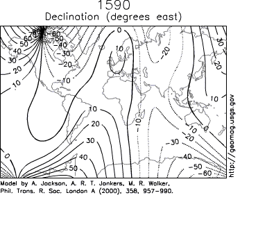
Declination
Declination is positive for an eastward deviation of the field relative to true north. It can be estimated by comparing the magnetic north/south heading on a compass with the direction of a celestial poleCelestial pole
The north and south celestial poles are the two imaginary points in the sky where the Earth's axis of rotation, indefinitely extended, intersects the imaginary rotating sphere of stars called the celestial sphere...
. Maps typically include information on the declination as an angle or a small diagram showing the relationship between magnetic north and true north. Information on declination for a region can be represented by a chart with isogonic lines (contour lines with each line representing a fixed declination).
Magnetic poles
The positions of the magnetic poles can be defined in at least two ways.Often, a magnetic (dip) pole is viewed as a point on the Earth's surface where the magnetic field
Magnetic field
A magnetic field is a mathematical description of the magnetic influence of electric currents and magnetic materials. The magnetic field at any given point is specified by both a direction and a magnitude ; as such it is a vector field.Technically, a magnetic field is a pseudo vector;...
is entirely vertical. Another way of saying this is that the inclination
Magnetic dip
Magnetic dip or magnetic inclination is the angle made by a compass needle with the horizontal at any point on the Earth's surface. Positive values of inclination indicate that the field is pointing downward, into the Earth, at the point of measurement...
of the Earth's field is at the North Magnetic Pole and at the South Magnetic Pole. The two poles wander independently of each other and are not at directly opposite positions on the globe. They can migrate rapidly: movements of up to km per year have been observed for the North Magnetic Pole. The magnetic equator is the line where the inclination is zero (the magnetic field is horizontal).
If a line is drawn parallel to the moment of the best-fitting magnetic dipole, the two positions where it intersects the Earth's surface are called the North and South geomagnetic pole
Geomagnetic pole
The geomagnetic poles are antipodal points where the axis of a theoretical dipole intersects the Earth's surface. This dipole is equivalent to a powerful bar magnet at the center of the Earth, and it is the dipole that comes closest to accounting for the magnetic field observed at the Earth's...
s. If the Earth's magnetic field were perfectly dipolar, the geomagnetic and magnetic dip poles would coincide and compasses would point towards them. However, the Earth's field has a significant contribution from non-dipolar terms
Multipole expansion
A multipole expansion is a mathematical series representing a function that depends on angles — usually the two angles on a sphere. These series are useful because they can often be truncated, meaning that only the first few terms need to be retained for a good approximation to the original...
, so the poles do not coincide and compasses do not generally point at either.
Magnetosphere
Some of the charged particles from the solar wind are trapped in the Van Allen radiation beltVan Allen radiation belt
The Van Allen radiation belt is a torus of energetic charged particles around Earth, which is held in place by Earth's magnetic field. It is believed that most of the particles that form the belts come from solar wind, and other particles by cosmic rays. It is named after its discoverer, James...
. A smaller number of particles from the solar wind manage to travel, as though on an electromagnetic energy transmission line, to the Earth's upper atmosphere and ionosphere
Ionosphere
The ionosphere is a part of the upper atmosphere, comprising portions of the mesosphere, thermosphere and exosphere, distinguished because it is ionized by solar radiation. It plays an important part in atmospheric electricity and forms the inner edge of the magnetosphere...
in the auroral zones. The only time the solar wind is observable on the Earth is when it is strong enough to produce phenomena such as the aurora
Aurora (astronomy)
An aurora is a natural light display in the sky particularly in the high latitude regions, caused by the collision of energetic charged particles with atoms in the high altitude atmosphere...
and geomagnetic storm
Geomagnetic storm
A geomagnetic storm is a temporary disturbance of the Earth's magnetosphere caused by a disturbance in the interplanetary medium. A geomagnetic storm is a major component of space weather and provides the input for many other components of space weather...
s. Bright auroras strongly heat the ionosphere, causing its plasma to expand into the magnetosphere
Magnetosphere
A magnetosphere is formed when a stream of charged particles, such as the solar wind, interacts with and is deflected by the intrinsic magnetic field of a planet or similar body. Earth is surrounded by a magnetosphere, as are the other planets with intrinsic magnetic fields: Mercury, Jupiter,...
, increasing the size of the plasma geosphere
Geosphere
The term geosphere is often used to refer to the densest parts of Earth, which consist mostly of rock and regolith. The geosphere consists of the inside of the Earth or other planets or bodies....
, and causing escape of atmospheric matter into the solar wind. Geomagnetic storm
Geomagnetic storm
A geomagnetic storm is a temporary disturbance of the Earth's magnetosphere caused by a disturbance in the interplanetary medium. A geomagnetic storm is a major component of space weather and provides the input for many other components of space weather...
s result when the pressure of plasmas contained inside the magnetosphere is sufficiently large to inflate and thereby distort the geomagnetic field.
The solar wind is responsible for the overall shape of Earth's magnetosphere, and fluctuations in its speed, density, direction, and entrained magnetic field strongly affect Earth's local space environment. For example, the levels of ionizing radiation and radio interference can vary by factors of hundreds to thousands; and the shape and location of the magnetopause and bow shock wave
Shock wave
A shock wave is a type of propagating disturbance. Like an ordinary wave, it carries energy and can propagate through a medium or in some cases in the absence of a material medium, through a field such as the electromagnetic field...
upstream of it can change by several Earth radii, exposing geosynchronous satellites to the direct solar wind. These phenomena are collectively called space weather
Space weather
Space weather is the concept of changing environmental conditions in near-Earth space or thespace from the Sun's atmosphere to the Earth's atmosphere. It is distinct from the concept ofweather within the Earth's planetary atmosphere...
. The mechanism of atmospheric stripping is caused by gas being caught in bubbles of magnetic field, which are ripped off by solar winds. Variations in the magnetic field strength have been correlated to rainfall variation within the tropics
Tropics
The tropics is a region of the Earth surrounding the Equator. It is limited in latitude by the Tropic of Cancer in the northern hemisphere at approximately N and the Tropic of Capricorn in the southern hemisphere at S; these latitudes correspond to the axial tilt of the Earth...
.
Short-term variations
The geomagnetic field changes on time scales from milliseconds to millions of years. Shorter time scales mostly arise from currents in the ionosphereIonosphere
The ionosphere is a part of the upper atmosphere, comprising portions of the mesosphere, thermosphere and exosphere, distinguished because it is ionized by solar radiation. It plays an important part in atmospheric electricity and forms the inner edge of the magnetosphere...
and magnetosphere
Magnetosphere
A magnetosphere is formed when a stream of charged particles, such as the solar wind, interacts with and is deflected by the intrinsic magnetic field of a planet or similar body. Earth is surrounded by a magnetosphere, as are the other planets with intrinsic magnetic fields: Mercury, Jupiter,...
, and some changes can be traced to geomagnetic storms or daily variations in currents. Changes over time scales of a year or more mostly reflect changes in the Earth's interior, particularly the iron-rich core
Inner core
The inner core of the Earth, its innermost hottest part as detected by seismological studies, is a primarily solid ball about in radius, or about 70% that of the Moon...
.
Frequently, the Earth's magnetosphere
Magnetosphere
A magnetosphere is formed when a stream of charged particles, such as the solar wind, interacts with and is deflected by the intrinsic magnetic field of a planet or similar body. Earth is surrounded by a magnetosphere, as are the other planets with intrinsic magnetic fields: Mercury, Jupiter,...
is hit by solar flare
Solar flare
A solar flare is a sudden brightening observed over the Sun surface or the solar limb, which is interpreted as a large energy release of up to 6 × 1025 joules of energy . The flare ejects clouds of electrons, ions, and atoms through the corona into space. These clouds typically reach Earth a day...
s causing geomagnetic storm
Geomagnetic storm
A geomagnetic storm is a temporary disturbance of the Earth's magnetosphere caused by a disturbance in the interplanetary medium. A geomagnetic storm is a major component of space weather and provides the input for many other components of space weather...
s, provoking displays of aurorae
Aurora (astronomy)
An aurora is a natural light display in the sky particularly in the high latitude regions, caused by the collision of energetic charged particles with atoms in the high altitude atmosphere...
. The short-term instability of the magnetic field is measured with the K-index
K-index
The K-index quantifies disturbances in the horizontal component of earth's magnetic field with an integer in the range 0-9 with 1 being calm and 5 or more indicating a geomagnetic storm. It is derived from the maximum fluctuations of horizontal components observed on a magnetometer during a...
.
Data from THEMIS
Themis
Themis is an ancient Greek Titaness. She is described as "of good counsel", and is the embodiment of divine order, law, and custom. Themis means "divine law" rather than human ordinance, literally "that which is put in place", from the verb τίθημι, títhēmi, "to put"...
show that the magnetic field, which interacts with the solar wind
Solar wind
The solar wind is a stream of charged particles ejected from the upper atmosphere of the Sun. It mostly consists of electrons and protons with energies usually between 1.5 and 10 keV. The stream of particles varies in temperature and speed over time...
, is reduced when the magnetic orientation is aligned between Sun and Earth - opposite to the previous hypothesis. During forthcoming solar storms
Coronal mass ejection
A coronal mass ejection is a massive burst of solar wind, other light isotope plasma, and magnetic fields rising above the solar corona or being released into space....
, this could result in blackout
Power outage
A power outage is a short- or long-term loss of the electric power to an area.There are many causes of power failures in an electricity network...
s and disruptions in artificial satellites.
Secular variation
Magnetic declination
Magnetic declination is the angle between magnetic north and true north. The declination is positive when the magnetic north is east of true north. The term magnetic variation is a synonym, and is more often used in navigation...
is observed to vary over tens of degrees. A movie on the right shows how global declinations have changed over the last few centuries.
The direction and intensity of the dipole change over time. Over the last two centuries the dipole strength has been decreasing at a rate of about 6.3% per century. At this rate of decrease, the field would reach zero in about 1600 years. However, this strength is about average for the last 7 thousand years, and the current rate of change is not unusual.
A prominent feature in the non-dipolar part of the secular variation is a westward drift at a rate of about 0.2 degrees per year. This drift is not the same everywhere and has varied over time. The globally averaged drift has been westward since about 1400 AD but eastward between about 1000 AD and 1400 AD.
Changes that predate magnetic observatories are recorded in archaeological and geological materials. Such changes are referred to as paleomagnetic secular variation or paleosecular variation (PSV). The records typically include long periods of small change with occasional large changes reflecting geomagnetic excursion
Geomagnetic excursion
A geomagnetic excursion, like a geomagnetic reversal, is a significant change in the Earth's magnetic field. Unlike reversals however, an excursion does not permanently change the large scale orientation of the field, but rather represents a dramatic, typically short-lived decrease in field...
s and geomagnetic reversal
Geomagnetic reversal
A geomagnetic reversal is a change in the Earth's magnetic field such that the positions of magnetic north and magnetic south are interchanged. The Earth's field has alternated between periods of normal polarity, in which the direction of the field was the same as the present direction, and reverse...
s.
Magnetic field reversals
Basalt
Basalt is a common extrusive volcanic rock. It is usually grey to black and fine-grained due to rapid cooling of lava at the surface of a planet. It may be porphyritic containing larger crystals in a fine matrix, or vesicular, or frothy scoria. Unweathered basalt is black or grey...
s, sediment cores taken from the ocean floors, and seafloor magnetic anomalies. Reversals occur at apparently random intervals ranging from less than 0.1 million years to as much as 50 million years. The most recent such event, called the Brunhes–Matuyama reversal, occurred about 780,000 years ago.
The past magnetic field is recorded mostly by iron oxides, such as magnetite
Magnetite
Magnetite is a ferrimagnetic mineral with chemical formula Fe3O4, one of several iron oxides and a member of the spinel group. The chemical IUPAC name is iron oxide and the common chemical name is ferrous-ferric oxide. The formula for magnetite may also be written as FeO·Fe2O3, which is one part...
, that have some form of ferrimagnetism
Ferrimagnetism
In physics, a ferrimagnetic material is one in which the magnetic moments of the atoms on different sublattices are opposed, as in antiferromagnetism; however, in ferrimagnetic materials, the opposing moments are unequal and a spontaneous magnetization remains...
or other magnetic ordering that allows the Earth's field to magnetize them. This remanent magnetization, or remanence, can be acquired in more than one way. In lava flows, the direction of the field is "frozen" in small magnetic particles as they cool, giving rise to a thermoremanent magnetization
Thermoremanent magnetization
When an igneous rock cools, it acquires a thermoremanent magnetization from the Earth's field. TRM can be much larger than it would be if exposed to the same field at room temperature . This remanence can also be very stable, lasting without significant change for millions of years...
. In sediments, the orientation of magnetic particles acquires a slight bias towards the magnetic field as they are deposited on an ocean floor or lake bottom. This is called detrital remanent magnetization.
Thermoremanent magnetization is the form of remanence that gives rise to the magnetic anomalies around ocean ridges
Mid-ocean ridge
A mid-ocean ridge is a general term for an underwater mountain system that consists of various mountain ranges , typically having a valley known as a rift running along its spine, formed by plate tectonics. This type of oceanic ridge is characteristic of what is known as an oceanic spreading...
. As the seafloor spreads, magma
Magma
Magma is a mixture of molten rock, volatiles and solids that is found beneath the surface of the Earth, and is expected to exist on other terrestrial planets. Besides molten rock, magma may also contain suspended crystals and dissolved gas and sometimes also gas bubbles. Magma often collects in...
wells up from the mantle
Mantle (geology)
The mantle is a part of a terrestrial planet or other rocky body large enough to have differentiation by density. The interior of the Earth, similar to the other terrestrial planets, is chemically divided into layers. The mantle is a highly viscous layer between the crust and the outer core....
and cools to form new basaltic crust. During the cooling, the basalt records the direction of the Earth's field. This new basalt forms on both sides of the ridge and moves away from it. When the Earth's field reverses, new basalt records the reversed direction. The result is a series of stripes that are symmetric about the ridge. A ship towing a magnetometer on the surface of the ocean can detect these stripes and infer the age of the ocean floor below. This provides information on the rate at which seafloor has spread in the past.
Radiometric dating
Radiometric dating
Radiometric dating is a technique used to date materials such as rocks, usually based on a comparison between the observed abundance of a naturally occurring radioactive isotope and its decay products, using known decay rates...
of lava flows has been used to establish a geomagnetic polarity time scale, part of which is shown in the image. This forms the basis of magnetostratigraphy
Magnetostratigraphy
Magnetostratigraphy is a geophysical correlation technique used to date sedimentary and volcanic sequences. The method works by collecting oriented samples at measured intervals throughout the section. The samples are analyzed to determine their characteristic remanent magnetization , that is, the...
, a geophysical correlation technique that can be used to date both sedimentary and volcanic sequences as well as the seafloor magnetic anomalies.
Studies of lava flows on Steens Mountain
Steens Mountain
Steens Mountain is a large fault-block mountain in the southeastern part of the U.S. state of Oregon. Located in Harney County, it stretches some and rises from an elevation of about above the Alvord Desert to its peak at...
, Oregon, indicate that the magnetic field could have shifted at a rate of up to 6 degrees per day at some time in Earth's history, which significantly challenges the popular understanding of how the Earth's magnetic field works.
Temporary dipole tilt variations that take the dipole axis across the equator and then back to the original polarity are known as excursions.
Earliest appearance
A paleomagnetic study of Australian red dacite and pillow basalt has estimated the magnetic field to have been present since at least .Earth's core and the geodynamo
The Earth's magnetic field is mostly caused by electric currentElectric current
Electric current is a flow of electric charge through a medium.This charge is typically carried by moving electrons in a conductor such as wire...
s in the liquid outer core
Outer core
The outer core of the Earth is a liquid layer about 2,266 kilometers thick composed of iron and nickel which lies above the Earth's solid inner core and below its mantle. Its outer boundary lies beneath the Earth's surface...
, which is composed of highly conductive molten iron. A magnetic field is generated by a feedback loop: current loops generate magnetic fields (Ampère's circuital law); a changing magnetic field generates an electric field (Faraday's law
Faraday's law of induction
Faraday's law of induction dates from the 1830s, and is a basic law of electromagnetism relating to the operating principles of transformers, inductors, and many types of electrical motors and generators...
); and the electric and magnetic fields exert a force on the charges that are flowing in currents (the Lorentz force
Lorentz force
In physics, the Lorentz force is the force on a point charge due to electromagnetic fields. It is given by the following equation in terms of the electric and magnetic fields:...
). These effects can be combined in an equation for the magnetic field only called the magnetic induction equation:
where is the velocity of the fluid, is the magnetic B-field
Magnetic field
A magnetic field is a mathematical description of the magnetic influence of electric currents and magnetic materials. The magnetic field at any given point is specified by both a direction and a magnitude ; as such it is a vector field.Technically, a magnetic field is a pseudo vector;...
; and is the magnetic diffusivity with electrical conductivity and permeability
Permeability (electromagnetism)
In electromagnetism, permeability is the measure of the ability of a material to support the formation of a magnetic field within itself. In other words, it is the degree of magnetization that a material obtains in response to an applied magnetic field. Magnetic permeability is typically...
. This is a partial differential equation. The term is the time derivative of the field; is the Laplacian and is the curl.
The first term on the right hand side of the induction equation is a diffusion
Diffusion
Molecular diffusion, often called simply diffusion, is the thermal motion of all particles at temperatures above absolute zero. The rate of this movement is a function of temperature, viscosity of the fluid and the size of the particles...
term. In a stationary fluid, the magnetic field declines and any concentrations of field spread out. If the Earth's dynamo shut off, the dipole part would disappear in a few tens of thousands of years.
In a perfect conductor , there would be no diffusion. By Lenz's law
Lenz's law
Lenz's law is a common way of understanding how electromagnetic circuits must always obey Newton's third law and The Law of Conservation of Energy...
, any change in the magnetic field would be immediately opposed by currents, so the flux through a given volume of fluid could not change. As the fluid moved, the magnetic field would go with it. The theorem describing this effect is called the frozen-in-field theorem. Even in a fluid with a finite conductivity, new field is generated by stretching field lines as the fluid moves in ways that deform it. This process could go on generating new field indefinitely, were it not that as the magnetic field increases in strength, it resists fluid motion.
The motion of the fluid is sustained by convection
Convection
Convection is the movement of molecules within fluids and rheids. It cannot take place in solids, since neither bulk current flows nor significant diffusion can take place in solids....
, motion driven by buoyancy. The temperature increases towards the center of the Earth, and the higher temperature of the fluid lower down makes it buoyant. This buoyancy is enhanced by chemical separation: As the core cools, some of the molten iron solidifies and is plated to the inner core
Inner core
The inner core of the Earth, its innermost hottest part as detected by seismological studies, is a primarily solid ball about in radius, or about 70% that of the Moon...
. In the process, lighter elements are left behind in the fluid, making it lighter. This is called compositional convection. A Coriolis effect
Coriolis effect
In physics, the Coriolis effect is a deflection of moving objects when they are viewed in a rotating reference frame. In a reference frame with clockwise rotation, the deflection is to the left of the motion of the object; in one with counter-clockwise rotation, the deflection is to the right...
, caused by the overall planetary rotation, tends to organize the flow into rolls aligned along the north-south polar axis.
The average magnetic field in the Earth's outer core was calculated to be 25 Gauss, 50 times stronger than the field at the surface.
Numerical models
The equations for the geodynamo are enormously difficult to solve, and the realism of the solutions is limited mainly by computer power. For decades, theorists were confined to creating kinematic dynamos in which the fluid motion is chosen in advance and the effect on the magnetic field calculated. Kinematic dynamo theory was mainly a matter of trying different flow geometries and seeing whether they could sustain a dynamo.The first self-consistent dynamo models, ones that determine both the fluid motions and the magnetic field, were developed by two groups in 1995, one in Japan and one in the United States. The latter received a lot of attention because it successfully reproduced some of the characteristics of the Earth's field, including geomagnetic reversals.
Currents in the ionosphere and magnetosphere
Electric currents induced in the ionosphereIonosphere
The ionosphere is a part of the upper atmosphere, comprising portions of the mesosphere, thermosphere and exosphere, distinguished because it is ionized by solar radiation. It plays an important part in atmospheric electricity and forms the inner edge of the magnetosphere...
generate magnetic fields. Such a field is always generated near where the atmosphere is closest to the Sun, causing daily alterations that can deflect surface magnetic fields by as much as one degree. Typical daily variations of field strength are about 25 nanoteslas (nT) (i.e. ~ 1:2,000), with variations over a few seconds of typically around 1 nT (i.e. ~ 1:50,000).
Crustal magnetic anomalies
Magnetometer
A magnetometer is a measuring instrument used to measure the strength or direction of a magnetic field either produced in the laboratory or existing in nature...
s detect minute deviations in the Earth's magnetic field caused by iron artifacts
Artifact (archaeology)
An artifact or artefact is "something made or given shape by man, such as a tool or a work of art, esp an object of archaeological interest"...
, kilns, some types of stone structures, and even ditches and midden
Midden
A midden, is an old dump for domestic waste which may consist of animal bone, human excrement, botanical material, vermin, shells, sherds, lithics , and other artifacts and ecofacts associated with past human occupation...
s in archaeological geophysics
Archaeological geophysics
Geophysical survey in archaeology most often refers to ground-based physical sensing techniques used for archaeological imaging or mapping. Remote sensing and marine surveys are also used in archaeology, but are generally considered separate disciplines...
. Using magnetic instruments adapted from airborne magnetic anomaly detector
Magnetic anomaly detector
A magnetic anomaly detector is an instrument used to detect minute variations in the Earth's magnetic field. The term refers specifically to magnetometers used by military forces to detect submarines ; the military MAD gear is a descendent of geomagnetic survey instruments used to search for...
s developed during World War II to detect submarines, the magnetic variations across the ocean floor have been mapped. Basalt
Basalt
Basalt is a common extrusive volcanic rock. It is usually grey to black and fine-grained due to rapid cooling of lava at the surface of a planet. It may be porphyritic containing larger crystals in a fine matrix, or vesicular, or frothy scoria. Unweathered basalt is black or grey...
— the iron-rich, volcanic rock making up the ocean floor — contains a strongly magnetic mineral (magnetite
Magnetite
Magnetite is a ferrimagnetic mineral with chemical formula Fe3O4, one of several iron oxides and a member of the spinel group. The chemical IUPAC name is iron oxide and the common chemical name is ferrous-ferric oxide. The formula for magnetite may also be written as FeO·Fe2O3, which is one part...
) and can locally distort compass readings. The distortion was recognized by Icelandic mariners as early as the late 18th century. More important, because the presence of magnetite gives the basalt measurable magnetic properties, these magnetic variations have provided another means to study the deep ocean floor. When newly formed rock cools, such magnetic materials record the Earth's magnetic field.
Detection
The Earth's magnetic field strength was measured by Carl Friedrich GaussCarl Friedrich Gauss
Johann Carl Friedrich Gauss was a German mathematician and scientist who contributed significantly to many fields, including number theory, statistics, analysis, differential geometry, geodesy, geophysics, electrostatics, astronomy and optics.Sometimes referred to as the Princeps mathematicorum...
in 1835 and has been repeatedly measured since then, showing a relative decay of about 10% over the last 150 years. The Magsat
Magsat
Magsat spacecraft was launched in the fall of 1979 and ended in the spring of 1980. The mission was to map the Earth's magnetic field, the satellite has two magnetometers...
satellite and later satellites have used 3-axis vector magnetometers to probe the 3-D structure of the Earth's magnetic field. The later Ørsted satellite allowed a comparison indicating a dynamic geodynamo in action that appears to be giving rise to an alternate pole under the Atlantic Ocean west of S. Africa.
Governments sometimes operate units that specialize in measurement of the Earth's magnetic field. These are geomagnetic observatories, typically part of a national Geological Survey
Geological survey
The term geological survey can be used to describe both the conduct of a survey for geological purposes and an institution holding geological information....
, for example the British Geological Survey
British Geological Survey
The British Geological Survey is a partly publicly funded body which aims to advance geoscientific knowledge of the United Kingdom landmass and its continental shelf by means of systematic surveying, monitoring and research. The BGS headquarters are in Keyworth, Nottinghamshire, but other centres...
's Eskdalemuir Observatory
Eskdalemuir Observatory
The Eskdalemuir Observatory is located near Eskdalemuir, Dumfries and Galloway, Scotland. Built in 1904, its remote location was chosen to minimise electrical interference with geomagnetic instruments, which were relocated there from Kew Observatory in 1908 after the advent of electrification in...
. Such observatories can measure and forecast magnetic conditions that sometimes affect communications, electric power, and other human activities. (See magnetic storm
Magnetic storm
Magnetic storm can refer to:* A geomagnetic storm* Magnetic Storm , the title of a book of paintings by Roger Dean* Magnetic Storm , the title of an hourlong PBS NOVA documentary about Earth's changing magnetic fields...
.)
The International Real-time Magnetic Observatory Network
Intermagnet
Intermagnet is a global network of observatories, monitoring the Earth's magnetic field.- Participating Countries :Intermagnet now has Geomagnetic Information Nodes in 5 continents....
, with over 100 interlinked geomagnetic observatories around the world has been recording the earths magnetic field since 1991.
The military determines local geomagnetic field characteristics, in order to detect anomalies in the natural background that might be caused by a significant metallic object such as a submerged submarine. Typically, these magnetic anomaly detector
Magnetic anomaly detector
A magnetic anomaly detector is an instrument used to detect minute variations in the Earth's magnetic field. The term refers specifically to magnetometers used by military forces to detect submarines ; the military MAD gear is a descendent of geomagnetic survey instruments used to search for...
s are flown in aircraft like the UK's Nimrod or towed as an instrument or an array of instruments from surface ships.
Commercially, geophysical prospecting
Prospecting
Prospecting is the physical search for minerals, fossils, precious metals or mineral specimens, and is also known as fossicking.Prospecting is a small-scale form of mineral exploration which is an organised, large scale effort undertaken by mineral resource companies to find commercially viable ore...
companies also use magnetic detectors to identify naturally occurring anomalies from ore
Ore
An ore is a type of rock that contains minerals with important elements including metals. The ores are extracted through mining; these are then refined to extract the valuable element....
bodies, such as the Kursk Magnetic Anomaly
Kursk Magnetic Anomaly
Kursk Magnetic Anomaly is a territory rich in iron ores located within the Kursk, Belgorod, and Voronezh oblasts in Russia, and constitutes a significant part of the Central Chernozyom Region...
.
Statistical models
Each measurement of the magnetic field is at a particular place and time. If an accurate estimate of the field at some other place and time is needed, the measurements must be converted to a model and the model used to make predictions.Spherical harmonics
Spherical harmonics
In mathematics, spherical harmonics are the angular portion of a set of solutions to Laplace's equation. Represented in a system of spherical coordinates, Laplace's spherical harmonics Y_\ell^m are a specific set of spherical harmonics that forms an orthogonal system, first introduced by Pierre...
. This was first done by Carl Friedrich Gauss
Carl Friedrich Gauss
Johann Carl Friedrich Gauss was a German mathematician and scientist who contributed significantly to many fields, including number theory, statistics, analysis, differential geometry, geodesy, geophysics, electrostatics, astronomy and optics.Sometimes referred to as the Princeps mathematicorum...
. Spherical harmonics are functions that oscillate over the surface of a sphere. They are the product of two functions, one that depends on latitude and one on longitude. The function of longitude is zero along zero or more great circles passing through the North and South Poles; the number of such nodal lines is the absolute value of the order . The function of latitude is zero along zero or more latitude circles; this plus the order is equal to the degree ℓ. Each harmonic is equivalent to a particular arrangement of magnetic charges at the center of the Earth. A monopole
Magnetic monopole
A magnetic monopole is a hypothetical particle in particle physics that is a magnet with only one magnetic pole . In more technical terms, a magnetic monopole would have a net "magnetic charge". Modern interest in the concept stems from particle theories, notably the grand unified and superstring...
is an isolated magnetic charge, which has never been observed. A dipole
Magnetic dipole
A magnetic dipole is the limit of either a closed loop of electric current or a pair of poles as the dimensions of the source are reduced to zero while keeping the magnetic moment constant. It is a magnetic analogue of the electric dipole, but the analogy is not complete. In particular, a magnetic...
is equivalent to two opposing charges brought close together and a quadrupole
Quadrupole
A quadrupole or quadrapole is one of a sequence of configurations of—for example—electric charge or current, or gravitational mass that can exist in ideal form, but it is usually just part of a multipole expansion of a more complex structure reflecting various orders of complexity.-Mathematical...
to two dipoles brought together. A quadrupole field is shown in the lower figure on the right.
Spherical harmonics can represent any scalar field
Scalar field
In mathematics and physics, a scalar field associates a scalar value to every point in a space. The scalar may either be a mathematical number, or a physical quantity. Scalar fields are required to be coordinate-independent, meaning that any two observers using the same units will agree on the...
(function of position) that satisfies certain properties. A magnetic field is a vector field
Vector field
In vector calculus, a vector field is an assignmentof a vector to each point in a subset of Euclidean space. A vector field in the plane for instance can be visualized as an arrow, with a given magnitude and direction, attached to each point in the plane...
, but if it is expressed in Cartesian components , each component is the derivative of the same scalar function called the magnetic potential
Magnetic potential
The term magnetic potential can be used for either of two quantities in classical electromagnetism: the magnetic vector potential, A, and the magnetic scalar potential, ψ...
. Analyses of the Earth's magnetic field use a modified version of the usual spherical harmonics that differ by a multiplicative factor. A least-squares fit to the magnetic field measurements gives the Earth's field as the sum of spherical harmonics, each multiplied by the best-fitting Gauss coefficient or .
The lowest-degree Gauss coefficient, , gives the contribution of an isolated magnetic charge, so it is zero. The next three coefficients – , , and – determine the direction and magnitude of the dipole contribution. The best fitting dipole is tilted at an angle of about with respect to the rotational axis, as described earlier.
Radial dependence
Spherical harmonic analysis can be used to distinguish internal from external sources if measurements are available at more than one height (for example, ground observatories and satellites). In that case, each term with coefficient or can be split into two terms: one that decreases with radius as and one that increases with radius as . The increasing terms fit the external sources (currents in the ionosphere and magnetosphere). However, averaged over a few years the external contributions average to zero.
The remaining terms predict that the potential of a dipole source drops off as . The magnetic field, being a derivative of the potential, drops off as . Quadrupole terms drop off as , and higher order terms drop off increasingly rapidly with the radius. The radius of the outer core
Outer core
The outer core of the Earth is a liquid layer about 2,266 kilometers thick composed of iron and nickel which lies above the Earth's solid inner core and below its mantle. Its outer boundary lies beneath the Earth's surface...
is about half of the radius of the Earth. If the field at the core-mantle boundary is fit to spherical harmonics, the dipole part is smaller by a factor of about at the surface, the quadrupole part , and so on. Thus, only the components with large wavelengths can be noticeable at the surface. From a variety of arguments, it is usually assumed that only terms up to degree or less have their origin in the core. These have wavelengths of about km or less. Smaller features are attributed to crustal anomalies.
Global models
The International Association of Geomagnetism and AeronomyInternational Association of Geomagnetism and Aeronomy
International Association of Geomagnetism and Aeronomy is the premier international scientific association promoting the study of terrestrial and planetary magnetism and space physics....
maintains a standard global field model called the International Geomagnetic Reference Field. It is updated every 5 years. The 11th-generation model, IGRF11, was developed using data from satellites (Ørsted, CHAMP
CHAMP
CHAllenging Minisatellite Payload is a German satellite launched July 15, 2000 from Plesetsk, Russia and was used for atmospheric and ionospheric research, as well as other geoscientific applications, such as GPS radio occultation....
and SAC-C) and a world network of geomagnetic observatories. The spherical harmonic expansion was truncated at degree 10, with 120 coefficients, until 2000. Subsequent models are truncated at degree 13 (195 coefficients).
Another global field model is produced jointly by the National Geophysical Data Center and the British Geological Survey
British Geological Survey
The British Geological Survey is a partly publicly funded body which aims to advance geoscientific knowledge of the United Kingdom landmass and its continental shelf by means of systematic surveying, monitoring and research. The BGS headquarters are in Keyworth, Nottinghamshire, but other centres...
. This model truncates at degree 12 (168 coefficients). It is the model used by the United States Department of Defense
United States Department of Defense
The United States Department of Defense is the U.S...
, the Ministry of Defence (United Kingdom)
Ministry of Defence (United Kingdom)
The Ministry of Defence is the United Kingdom government department responsible for implementation of government defence policy and is the headquarters of the British Armed Forces....
, the North Atlantic Treaty Organization, and the International Hydrographic Office as well as in many civilian navigation systems.
A third model, produced by the Goddard Space Flight Center
Goddard Space Flight Center
The Goddard Space Flight Center is a major NASA space research laboratory established on May 1, 1959 as NASA's first space flight center. GSFC employs approximately 10,000 civil servants and contractors, and is located approximately northeast of Washington, D.C. in Greenbelt, Maryland, USA. GSFC,...
(NASA
NASA
The National Aeronautics and Space Administration is the agency of the United States government that is responsible for the nation's civilian space program and for aeronautics and aerospace research...
and GSFC) and the Danish Space Research Institute
Danish Space Research Institute
Danish Space Research Institute was the space agency of Denmark from 1966 to 2005. It was a Danish sector research institute formed in 1966 under the Danish Ministry for Education and Research, later the Danish Ministry of Science Technology and Innovation...
, uses a "comprehensive modeling" approach that attempts to reconcile data with greatly varying temporal and spatial resolution from ground and satellite sources.
Biomagnetism
Animals including birds and turtles can detect the Earth's magnetic field, and use the field to navigate during migrationBird migration
Bird migration is the regular seasonal journey undertaken by many species of birds. Bird movements include those made in response to changes in food availability, habitat or weather. Sometimes, journeys are not termed "true migration" because they are irregular or in only one direction...
. Cows and wild deer tend to align their bodies north-south while relaxing, but not when the animals are under high voltage power lines, leading researchers to believe magnetism is responsible.
See also
- Geomagnetic jerkGeomagnetic jerkIn geophysics, a geomagnetic jerk or secular geomagnetic variation impulse is a relatively sudden change in the second derivative of the Earth's magnetic field with respect to time....
- History of geomagnetismHistory of geomagnetismThe history of geomagnetism is concerned with the history of the study of Earth's magnetic field. It encompasses the history of navigation using compasses, studies of the prehistoric magnetic field , and applications to plate tectonics.Magnetism has been known since prehistory, but knowledge of the...
- Magnetic field of the MoonMagnetic field of the Moonthumb|right|300px|Total magnetic field strength at the surface of the Moon as derived from the Lunar Prospector electron reflectometer experiment.The external magnetic field of the Moon is very weak in comparison to that of the Earth...
- Magnetosphere of Jupiter
Magnetic survey ships:
- Carnegie (ship)Carnegie (ship)The Carnegie was a brigantine yacht, equipped as a research vessel, constructed almost entirely from wood and other non-magnetic materials to allow sensitive magnetic measurements to be taken for the Carnegie Institution's Department of Terrestrial Magnetism. She carried out a series of cruises...
- Voyages of Christopher Columbus—Magnetic deviation
- Galilee (ship)Galilee (ship)The Galilee was a brigantine, built in 1891, designed by Matthew Turner. She started on the packet line between San Francisco and Tahiti and was reckoned a very fast ship. In 1905 she was chartered by the Carnegie Institution's Department of Terrestrial Magnetism and converted into a magnetic...
Portals:
External links
- Geomagnetism & Paleomagnetism background material. American Geophysical Union Geomagnetism and Paleomagnetism Section.
- National Geomagnetism Program. United States Geological SurveyUnited States Geological SurveyThe United States Geological Survey is a scientific agency of the United States government. The scientists of the USGS study the landscape of the United States, its natural resources, and the natural hazards that threaten it. The organization has four major science disciplines, concerning biology,...
, March 08, 2011. - BGS Geomagnetism. Information on monitoring and modeling the geomagnetic field. British Geological Survey, August 2005.
- William J. Broad, Will Compasses Point South?. New York Times, July 13, 2004.
- John Roach, Why Does Earth's Magnetic Field Flip?. National Geographic, September 27, 2004.
- Magnetic Storm. PBSPublic Broadcasting ServiceThe Public Broadcasting Service is an American non-profit public broadcasting television network with 354 member TV stations in the United States which hold collective ownership. Its headquarters is in Arlington, Virginia....
NOVANOVA (TV series)Nova is a popular science television series from the U.S. produced by WGBH Boston. It can be seen on the Public Broadcasting Service in the United States, and in more than 100 other countries...
, 2003. (ed. about pole reversals) - When North Goes South. Projects in Scientific Computing, 1996.
- 3D Earth Magnetic Field Charged-Particle Simulator. Tool dedicated to the 3d simulation of charged particles in the magnetosphere.. [VRML Plug-in Required]
- The Great Magnet, the Earth, History of the discovery of Earth's magnetic field by David P. Stern.
- Exploration of the Earth's Magnetosphere, Educational web site by David P. Stern and Mauricio Peredo
- Dr. Dan Lathrop: The study of the Earth's magnetic field. Interview with Dr. Dan Lathrop, Geophysicist at the University of Maryland, about his experiments with the Earth's core and magnetic field. 7 - 3 - 2008
- International Geomagnetic Reference Field 2011
- Global evolution/anomaly of the Earth's magnetic field Sweeps are in 10 degree steps at 10 years intervals. Based on data from: The Institute of Geophysics, ETH Zurich
Category:Geomagnetism
Category:Geophysics
Category:Magnetism
ar:مغناطيسية أرضية
bs:Zemljino magnetno polje
bg:Земно магнитно поле
ca:Camp magnètic terrestre
cs:Magnetické pole Země
da:Jordens magnetfelt
de:Erdmagnetfeld
nv:Nahasdzáán bimagnetic field
el:Γήινος μαγνητισμός
es:Campo magnético terrestre
eo:Geomagnetiko
fa:میدان مغناطیسی زمین
fr:Champ magnétique terrestre
gl:Campo magnético terrestre
ko:지자기
hi:पृथ्वी का चुम्बकीय क्षेत्र
hr:Zemljino magnetno polje
it:Campo geomagnetico
he:השדה המגנטי של כדור הארץ
lv:Zemes magnētiskais lauks
lb:Äerdmagnéitfeld
hu:Földi mágneses mező
nl:Aardmagnetisch veld
ja:地磁気
no:Jordens magnetfelt
pl:Ziemskie pole magnetyczne
pt:Campo magnético terrestre
ro:Geomagnetism
ru:Магнитное поле Земли
sk:Magnetické pole Zeme
sr:Магнетско поље Земље
sh:Magnetsko polje Zemlje
fi:Maan magneettikenttä
sv:Jordens magnetfält
ta:புவியின் காந்தப்புலம்
th:สนามแม่เหล็กของโลก
tr:Jeomanyetizma
uk:Магнітне поле Землі
vi:Từ trường Trái Đất
zh:地磁场