

Cartography of India
Encyclopedia
The cartography
of India
begins with early charts for navigation and constructional plans for buildings. Indian traditions influenced Tibet
an and Islamic traditions, and in turn, were influenced by the British
cartographers who solidified modern concepts into India's map making.
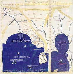
A prominent foreign geographer and cartographer was Hellenistic geographer Ptolemy
(90–168) who researched at the library in Alexandria
to produce a detailed eight-volume record of world geography. During the Middle Ages, India sees some exploration by Chinese
and Muslim geographers, while European maps of India remain very sketchy.
A prominent medieval cartographer was Persian geographer Abu Rayhan Biruni (973–1048) who visited India and studied the country's geography extensively.
European maps become more accurate with the Age of Exploration and Portuguese India
from the 16th century. The first modern maps were produced by Survey of India
, established in 1767 by the British East India Company
. Survey of India remains in continued existence as the official mapping authority of the Republic of India.
(2008) proposes that the Bronze Age Indus Valley Civilization
(ca. 2500–1900 BCE) may have known "cartographic activity" based on a number of excavated surveying instruments and measuring rods and that the use of large scale constructional plans, cosmological drawings, and cartographic material was known in India with some regularity since the Vedic period
(1 millennium BCE).
Susan Gole (1990) comments on the cartographic traditions in early India:
 Cartography
of India
as a part of the greater continent of Asia
develops in Classical Antiquity
.
In Greek cartography, India appears as a remote land on the eastern fringe of Asia in the 5th century BC (Hecataeus of Miletus). More detailed knowledge becomes available after the conquests of Alexander the Great, and the 3rd century BC geographer Eratosthenes
has a clearer idea of the size and location of India. By the 1st century, at least the western coast of India is well known to Hellenistic geography, with itineraries such as the Periplus of the Erythraean Sea
. Ptolemy
by the 2nd century has good knowledge of Indian Sea, including an oversized Sri Lanka
(Taprobane), but not of the interior of the subcontinent.
Native Indian cartographic traditions before the Hellenistic period remain rudimentary. Early forms of cartography in India
included legendary paintings; maps of locations described in Indian epic poetry
, for example the Ramayana
. These works contained descriptions of legendary places, and often even described the nature of the mythological inhabitants of a particular location. Early Indian cartography showed little knowledge of scale, the important parts of the map were shown to be larger than others (Gole 1990).
Indian cartographic traditions also covered the locations of the Pole star
, and other constellations of use. These charts may have been in use by the beginning of the Common Era
for purposes of navigation.
Other early maps in India include the Udayagiri
wall sculpture—made under the Gupta empire
in 400 CE—showing the meeting of the Ganges and the Yamuna
.
conceived paintings which indicated geographical regions. The boundaries of land, granted to the Brahman
priests of India by their patrons, were described in detail. The descriptions indicated good geographical knowledge and in one case over 75 details of the land granted have been found. The Chinese
records of the Tang dynasty
show that a map of the neighboring Indian region was gifted to Wang Hiuen-tse by its king.
In the 9th century, Islamic geographers under Abbasid Caliph Al-Ma'mun
improved on Ptolemy's work and depicted the Indian Ocean
as an open body of water
instead of a land-locked sea
as Ptolemy had done. The Iranian
geographers Abū Muhammad al-Hasan al-Hamdānī and Habash al-Hasib al-Marwazi set the Prime Meridian
of their maps at Ujjain
, a centre of Indian astronomy. In the early 11th century, the Persian
geographer Abu Rayhan Biruni visited India and studied the country's geography extensively. He was considered the most skilled when it came to mapping cities
and measuring the distances between them, which he did for many cities in the western Indian subcontinent
. He also wrote extensively on the geology of India. In 1154, the Arab
geographer Muhammad al-Idrisi
included a section on the cartography and geography of India and its neighboring countries in his world atlas, Tabula Rogeriana
.
European scholar Francesco I reproduced a number of Indian maps in his magnum opus La Cartografia Antica dell India. Out these maps two have been reproduced using a manuscript of Lokaprakasa—originally compiled by the polymath Ksemendra (Kashmir
, 11th century CE)—as a source. The other manuscript, used as a source by Francesco I, is titled Samgrahani. The early volumes of the Encyclopedia Britannica also described cartographic charts made by the Dravidian people of India.
The cartographic tradition of India influenced the map making tradition of Tibet
, where maps of Indian origin have been discovered. Islamic cartography was also influenced by the Indian tradition as a result of extensive contact.
document detailing India's history and traditions, contain references to locations indicated in earlier Indian cartographic traditions.
The seamless globe
was invented in Kashmir by Ali Kashmiri ibn Luqman in 998 AH (1589-90 CE), and twenty other such globes were later produced in Lahore
and Kashmir during the Mughal Empire
. Before they were rediscovered in the 1980s, it was believed by modern metallurgists to be technically impossible to produce metal globes without any seams, even with modern technology. These Mughal metallurgists pioneered the method of lost-wax casting in order to produce these globes.
The scholar Sadiq Isfahani of Jaunpur
compiled an atlas
of the parts of the world which he held to be 'suitable for human life'. The 32 sheet atlas—with maps oriented towards the south as was the case with Islamic works of the era—is part of a larger scholarly work compiled by Isfahani during 1647 CE. According to Joseph E. Schwartzberg (2008): 'The largest known Indian map, depicting the former Rajput
capital at Amber
in remarkable house-by-house detail, measures 661 × 645 cm. (260 × 254 in., or approximately 22 × 21 ft).'
 A map describing the kingdom of Nepal, four feet in length and about two and a half feet in breadth, was presented to Warren Hastings
. In this raised-relief map
the mountains were elevated above the surface and several geographical elements were indicated in different colors. The Europeans used 'scale-bars' in their cartographic tradition. Upon their arrival in India during the middle ages
, the indigenous Indian measures were reported back to Europe, and first published by Guillaume de I'Isle in 1722 as Carte des Costes de Malabar et de Coromandel.
With the establishment of the British Raj
in India, modern European cartographic traditions were officially employed by the British Survey of India
(1767). One British observer commented on the tradition of native Indian cartography:
Thomas George Montgomerie
organized several cartographic expeditions to map Tibet
, as well as China
. Mohamed-i-Hameed, Nain Singh
and Mani Singh were among the agents employed by the British for their cartographic operations. Nain Singh, in particular, became famous for his geographical knowledge of Asia, and was awarded several honors for his expeditions.
s and printing
. Satellite imageries
, aerial photographs and video surveying
techniques are also used. The Indian IRS-P5 (CARTOSAT-1
) was equipped with high resolution panchromatic equipment to enable it for cartographic purposes. IRS-P5 (CARTOSAT-1) was followed by a more advanced model named IRS-P6 developed also for agricultural applications. The CARTOSAT-2
project, equipped with single panchromatic camera which supported scene specific on-spot images, succeed the CARTOSAT-1 project.
Cartography
Cartography is the study and practice of making maps. Combining science, aesthetics, and technique, cartography builds on the premise that reality can be modeled in ways that communicate spatial information effectively.The fundamental problems of traditional cartography are to:*Set the map's...
of India
History of India
The history of India begins with evidence of human activity of Homo sapiens as long as 75,000 years ago, or with earlier hominids including Homo erectus from about 500,000 years ago. The Indus Valley Civilization, which spread and flourished in the northwestern part of the Indian subcontinent from...
begins with early charts for navigation and constructional plans for buildings. Indian traditions influenced Tibet
Tibet
Tibet is a plateau region in Asia, north-east of the Himalayas. It is the traditional homeland of the Tibetan people as well as some other ethnic groups such as Monpas, Qiang, and Lhobas, and is now also inhabited by considerable numbers of Han and Hui people...
an and Islamic traditions, and in turn, were influenced by the British
United Kingdom
The United Kingdom of Great Britain and Northern IrelandIn the United Kingdom and Dependencies, other languages have been officially recognised as legitimate autochthonous languages under the European Charter for Regional or Minority Languages...
cartographers who solidified modern concepts into India's map making.
A prominent foreign geographer and cartographer was Hellenistic geographer Ptolemy
Ptolemy
Claudius Ptolemy , was a Roman citizen of Egypt who wrote in Greek. He was a mathematician, astronomer, geographer, astrologer, and poet of a single epigram in the Greek Anthology. He lived in Egypt under Roman rule, and is believed to have been born in the town of Ptolemais Hermiou in the...
(90–168) who researched at the library in Alexandria
Alexandria
Alexandria is the second-largest city of Egypt, with a population of 4.1 million, extending about along the coast of the Mediterranean Sea in the north central part of the country; it is also the largest city lying directly on the Mediterranean coast. It is Egypt's largest seaport, serving...
to produce a detailed eight-volume record of world geography. During the Middle Ages, India sees some exploration by Chinese
Chinese geography
Native Chinese geography begins in the Warring States period . It expands its scope beyond the Chinese homeland with the growth of the Chinese Empire under the Han Dynasty...
and Muslim geographers, while European maps of India remain very sketchy.
A prominent medieval cartographer was Persian geographer Abu Rayhan Biruni (973–1048) who visited India and studied the country's geography extensively.
European maps become more accurate with the Age of Exploration and Portuguese India
Portuguese India
The Portuguese Viceroyalty of India , later the Portuguese State of India , was the aggregate of Portugal's colonial holdings in India.The government started in 1505, six years after the discovery of a sea route to India by Vasco da Gama, with the nomination of the first Viceroy Francisco de...
from the 16th century. The first modern maps were produced by Survey of India
Survey of India
The Survey of India is India's central engineering agency in charge of mapping and surveying. Set up in 1767 to help consolidate the territories of the British East India Company, it is one of the oldest Engineering Departments of the Government of India...
, established in 1767 by the British East India Company
British East India Company
The East India Company was an early English joint-stock company that was formed initially for pursuing trade with the East Indies, but that ended up trading mainly with the Indian subcontinent and China...
. Survey of India remains in continued existence as the official mapping authority of the Republic of India.
Prehistory
Joseph E. SchwartzbergJoseph E. Schwartzberg
Joseph E. Schwartzberg is a University of Minnesota professor emeritus of geography and prominent world federalist scholar.Schwartzberg was born in Brooklyn, New York in 1928. He has done significant work in seeking solutions to the Kashmir conflict. He also developed the idea of "weighted voting"...
(2008) proposes that the Bronze Age Indus Valley Civilization
Indus Valley Civilization
The Indus Valley Civilization was a Bronze Age civilization that was located in the northwestern region of the Indian subcontinent, consisting of what is now mainly modern-day Pakistan and northwest India...
(ca. 2500–1900 BCE) may have known "cartographic activity" based on a number of excavated surveying instruments and measuring rods and that the use of large scale constructional plans, cosmological drawings, and cartographic material was known in India with some regularity since the Vedic period
Vedic period
The Vedic period was a period in history during which the Vedas, the oldest scriptures of Hinduism, were composed. The time span of the period is uncertain. Philological and linguistic evidence indicates that the Rigveda, the oldest of the Vedas, was composed roughly between 1700–1100 BCE, also...
(1 millennium BCE).
- 'Though not numerous, a number of map-like graffiti appear among the thousands of Stone Age Indian cave paintings; and at least one complex Mesolithic diagram is believed to be a representation of the cosmos.'
Susan Gole (1990) comments on the cartographic traditions in early India:
Antiquity
Cartography
Cartography is the study and practice of making maps. Combining science, aesthetics, and technique, cartography builds on the premise that reality can be modeled in ways that communicate spatial information effectively.The fundamental problems of traditional cartography are to:*Set the map's...
of India
Indian subcontinent
The Indian subcontinent, also Indian Subcontinent, Indo-Pak Subcontinent or South Asian Subcontinent is a region of the Asian continent on the Indian tectonic plate from the Hindu Kush or Hindu Koh, Himalayas and including the Kuen Lun and Karakoram ranges, forming a land mass which extends...
as a part of the greater continent of Asia
Cartography of Asia
- Antiquity :Babylon in Southwest Asia is at the center of the very earliest world maps, beginning with the Babylonian world map in the 6th century BC; it is a clay tablet 'localized' world map of Babylon, rivers, encircling ocean, and terrain, surrounded by 'islands' in a 7-star format. In...
develops in Classical Antiquity
Classical antiquity
Classical antiquity is a broad term for a long period of cultural history centered on the Mediterranean Sea, comprising the interlocking civilizations of ancient Greece and ancient Rome, collectively known as the Greco-Roman world...
.
In Greek cartography, India appears as a remote land on the eastern fringe of Asia in the 5th century BC (Hecataeus of Miletus). More detailed knowledge becomes available after the conquests of Alexander the Great, and the 3rd century BC geographer Eratosthenes
Eratosthenes
Eratosthenes of Cyrene was a Greek mathematician, poet, athlete, geographer, astronomer, and music theorist.He was the first person to use the word "geography" and invented the discipline of geography as we understand it...
has a clearer idea of the size and location of India. By the 1st century, at least the western coast of India is well known to Hellenistic geography, with itineraries such as the Periplus of the Erythraean Sea
Periplus of the Erythraean Sea
The Periplus of the Erythraean Sea or Periplus of the Red Sea is a Greco-Roman periplus, written in Greek, describing navigation and trading opportunities from Roman Egyptian ports like Berenice along the coast of the Red Sea, and others along Northeast Africa and India...
. Ptolemy
Ptolemy
Claudius Ptolemy , was a Roman citizen of Egypt who wrote in Greek. He was a mathematician, astronomer, geographer, astrologer, and poet of a single epigram in the Greek Anthology. He lived in Egypt under Roman rule, and is believed to have been born in the town of Ptolemais Hermiou in the...
by the 2nd century has good knowledge of Indian Sea, including an oversized Sri Lanka
Sri Lanka
Sri Lanka, officially the Democratic Socialist Republic of Sri Lanka is a country off the southern coast of the Indian subcontinent. Known until 1972 as Ceylon , Sri Lanka is an island surrounded by the Indian Ocean, the Gulf of Mannar and the Palk Strait, and lies in the vicinity of India and the...
(Taprobane), but not of the interior of the subcontinent.
Native Indian cartographic traditions before the Hellenistic period remain rudimentary. Early forms of cartography in India
India
India , officially the Republic of India , is a country in South Asia. It is the seventh-largest country by geographical area, the second-most populous country with over 1.2 billion people, and the most populous democracy in the world...
included legendary paintings; maps of locations described in Indian epic poetry
Epic poetry
An epic is a lengthy narrative poem, ordinarily concerning a serious subject containing details of heroic deeds and events significant to a culture or nation. Oral poetry may qualify as an epic, and Albert Lord and Milman Parry have argued that classical epics were fundamentally an oral poetic form...
, for example the Ramayana
Ramayana
The Ramayana is an ancient Sanskrit epic. It is ascribed to the Hindu sage Valmiki and forms an important part of the Hindu canon , considered to be itihāsa. The Ramayana is one of the two great epics of India and Nepal, the other being the Mahabharata...
. These works contained descriptions of legendary places, and often even described the nature of the mythological inhabitants of a particular location. Early Indian cartography showed little knowledge of scale, the important parts of the map were shown to be larger than others (Gole 1990).
Indian cartographic traditions also covered the locations of the Pole star
Pole star
The term "Pole Star" usually refers to Polaris, which is the current northern pole star, also known as the North Star.In general, however, a pole star is a visible star, especially a prominent one, that is approximately aligned with the Earth's axis of rotation; that is, a star whose apparent...
, and other constellations of use. These charts may have been in use by the beginning of the Common Era
Common Era
Common Era ,abbreviated as CE, is an alternative designation for the calendar era originally introduced by Dionysius Exiguus in the 6th century, traditionally identified with Anno Domini .Dates before the year 1 CE are indicated by the usage of BCE, short for Before the Common Era Common Era...
for purposes of navigation.
Other early maps in India include the Udayagiri
Udayagiri
Udayagiri is the name of many places in India, among them:*Udayagiri Fort, one in Tamil Nadu and the other in Andhra Pradesh...
wall sculpture—made under the Gupta empire
Gupta Empire
The Gupta Empire was an ancient Indian empire which existed approximately from 320 to 550 CE and covered much of the Indian Subcontinent. Founded by Maharaja Sri-Gupta, the dynasty was the model of a classical civilization. The peace and prosperity created under leadership of Guptas enabled the...
in 400 CE—showing the meeting of the Ganges and the Yamuna
Yamuna
The Yamuna is the largest tributary river of the Ganges in northern India...
.
Middle Ages
The 8th century scholar BhavabhutiBhavabhuti
Bhavabhuti was an 8th century scholar of India noted for his plays and poetry, written in Sanskrit. His plays are considered equivalent to the works of Kalidasa...
conceived paintings which indicated geographical regions. The boundaries of land, granted to the Brahman
Brahman
In Hinduism, Brahman is the one supreme, universal Spirit that is the origin and support of the phenomenal universe. Brahman is sometimes referred to as the Absolute or Godhead which is the Divine Ground of all being...
priests of India by their patrons, were described in detail. The descriptions indicated good geographical knowledge and in one case over 75 details of the land granted have been found. The Chinese
China
Chinese civilization may refer to:* China for more general discussion of the country.* Chinese culture* Greater China, the transnational community of ethnic Chinese.* History of China* Sinosphere, the area historically affected by Chinese culture...
records of the Tang dynasty
Tang Dynasty
The Tang Dynasty was an imperial dynasty of China preceded by the Sui Dynasty and followed by the Five Dynasties and Ten Kingdoms Period. It was founded by the Li family, who seized power during the decline and collapse of the Sui Empire...
show that a map of the neighboring Indian region was gifted to Wang Hiuen-tse by its king.
In the 9th century, Islamic geographers under Abbasid Caliph Al-Ma'mun
Al-Ma'mun
Abū Jaʿfar Abdullāh al-Māʾmūn ibn Harūn was an Abbasid caliph who reigned from 813 until his death in 833...
improved on Ptolemy's work and depicted the Indian Ocean
Indian Ocean
The Indian Ocean is the third largest of the world's oceanic divisions, covering approximately 20% of the water on the Earth's surface. It is bounded on the north by the Indian Subcontinent and Arabian Peninsula ; on the west by eastern Africa; on the east by Indochina, the Sunda Islands, and...
as an open body of water
Ocean
An ocean is a major body of saline water, and a principal component of the hydrosphere. Approximately 71% of the Earth's surface is covered by ocean, a continuous body of water that is customarily divided into several principal oceans and smaller seas.More than half of this area is over 3,000...
instead of a land-locked sea
Sea
A sea generally refers to a large body of salt water, but the term is used in other contexts as well. Most commonly, it means a large expanse of saline water connected with an ocean, and is commonly used as a synonym for ocean...
as Ptolemy had done. The Iranian
Iranian peoples
The Iranian peoples are an Indo-European ethnic-linguistic group, consisting of the speakers of Iranian languages, a major branch of the Indo-European language family, as such forming a branch of Indo-European-speaking peoples...
geographers Abū Muhammad al-Hasan al-Hamdānī and Habash al-Hasib al-Marwazi set the Prime Meridian
Prime Meridian
The Prime Meridian is the meridian at which the longitude is defined to be 0°.The Prime Meridian and its opposite the 180th meridian , which the International Date Line generally follows, form a great circle that divides the Earth into the Eastern and Western Hemispheres.An international...
of their maps at Ujjain
Ujjain
Ujjain , is an ancient city of Malwa region in central India, on the eastern bank of the Kshipra River , today part of the state of Madhya Pradesh. It is the administrative centre of Ujjain District and Ujjain Division.In ancient times the city was called Ujjayini...
, a centre of Indian astronomy. In the early 11th century, the Persian
Persian people
The Persian people are part of the Iranian peoples who speak the modern Persian language and closely akin Iranian dialects and languages. The origin of the ethnic Iranian/Persian peoples are traced to the Ancient Iranian peoples, who were part of the ancient Indo-Iranians and themselves part of...
geographer Abu Rayhan Biruni visited India and studied the country's geography extensively. He was considered the most skilled when it came to mapping cities
City
A city is a relatively large and permanent settlement. Although there is no agreement on how a city is distinguished from a town within general English language meanings, many cities have a particular administrative, legal, or historical status based on local law.For example, in the U.S...
and measuring the distances between them, which he did for many cities in the western Indian subcontinent
Indian subcontinent
The Indian subcontinent, also Indian Subcontinent, Indo-Pak Subcontinent or South Asian Subcontinent is a region of the Asian continent on the Indian tectonic plate from the Hindu Kush or Hindu Koh, Himalayas and including the Kuen Lun and Karakoram ranges, forming a land mass which extends...
. He also wrote extensively on the geology of India. In 1154, the Arab
Arab
Arab people, also known as Arabs , are a panethnicity primarily living in the Arab world, which is located in Western Asia and North Africa. They are identified as such on one or more of genealogical, linguistic, or cultural grounds, with tribal affiliations, and intra-tribal relationships playing...
geographer Muhammad al-Idrisi
Muhammad al-Idrisi
Abu Abd Allah Muhammad al-Idrisi al-Qurtubi al-Hasani al-Sabti or simply Al Idrisi was a Moroccan Muslim geographer, cartographer, Egyptologist and traveller who lived in Sicily, at the court of King Roger II. Muhammed al-Idrisi was born in Ceuta then belonging to the Almoravid Empire and died in...
included a section on the cartography and geography of India and its neighboring countries in his world atlas, Tabula Rogeriana
Tabula Rogeriana
The Nuzhat al-mushtaq fi'khtiraq al-afaq lit. "the book of pleasant journeys into faraway lands", most often known as the Tabula Rogeriana , is a description of the world and world map created by the Arab geographer, Muhammad al-Idrisi, in 1154...
.
European scholar Francesco I reproduced a number of Indian maps in his magnum opus La Cartografia Antica dell India. Out these maps two have been reproduced using a manuscript of Lokaprakasa—originally compiled by the polymath Ksemendra (Kashmir
Kashmir
Kashmir is the northwestern region of the Indian subcontinent. Until the mid-19th century, the term Kashmir geographically denoted only the valley between the Great Himalayas and the Pir Panjal mountain range...
, 11th century CE)—as a source. The other manuscript, used as a source by Francesco I, is titled Samgrahani. The early volumes of the Encyclopedia Britannica also described cartographic charts made by the Dravidian people of India.
The cartographic tradition of India influenced the map making tradition of Tibet
Tibet
Tibet is a plateau region in Asia, north-east of the Himalayas. It is the traditional homeland of the Tibetan people as well as some other ethnic groups such as Monpas, Qiang, and Lhobas, and is now also inhabited by considerable numbers of Han and Hui people...
, where maps of Indian origin have been discovered. Islamic cartography was also influenced by the Indian tradition as a result of extensive contact.
Mughal era
Maps from the Ain-e-Akbari, a MughalMughal era
The Mughal era is a historic period of the Mughal Empire in South Asia . It ran from the early 15th century to a point in the early 18th century when the Mughal Emperors' power had dwindled...
document detailing India's history and traditions, contain references to locations indicated in earlier Indian cartographic traditions.
The seamless globe
Globe
A globe is a three-dimensional scale model of Earth or other spheroid celestial body such as a planet, star, or moon...
was invented in Kashmir by Ali Kashmiri ibn Luqman in 998 AH (1589-90 CE), and twenty other such globes were later produced in Lahore
Lahore
Lahore is the capital of the Pakistani province of Punjab and the second largest city in the country. With a rich and fabulous history dating back to over a thousand years ago, Lahore is no doubt Pakistan's cultural capital. One of the most densely populated cities in the world, Lahore remains a...
and Kashmir during the Mughal Empire
Mughal Empire
The Mughal Empire , or Mogul Empire in traditional English usage, was an imperial power from the Indian Subcontinent. The Mughal emperors were descendants of the Timurids...
. Before they were rediscovered in the 1980s, it was believed by modern metallurgists to be technically impossible to produce metal globes without any seams, even with modern technology. These Mughal metallurgists pioneered the method of lost-wax casting in order to produce these globes.
The scholar Sadiq Isfahani of Jaunpur
Jaunpur, Uttar Pradesh
Jaunpur is a city and a municipal board in Jaunpur district in the Indian state of Uttar Pradesh.Jaunpur district is located to the northwest of the district of Varanasi in the eastern part of the North Indian state of Uttar Pradesh. According to the 2001 census, Jaunpur district had a population...
compiled an atlas
Atlas
An atlas is a collection of maps; it is typically a map of Earth or a region of Earth, but there are atlases of the other planets in the Solar System. Atlases have traditionally been bound into book form, but today many atlases are in multimedia formats...
of the parts of the world which he held to be 'suitable for human life'. The 32 sheet atlas—with maps oriented towards the south as was the case with Islamic works of the era—is part of a larger scholarly work compiled by Isfahani during 1647 CE. According to Joseph E. Schwartzberg (2008): 'The largest known Indian map, depicting the former Rajput
Rajput
A Rajput is a member of one of the patrilineal clans of western, central, northern India and in some parts of Pakistan. Rajputs are descendants of one of the major ruling warrior classes in the Indian subcontinent, particularly North India...
capital at Amber
Amber
Amber is fossilized tree resin , which has been appreciated for its color and natural beauty since Neolithic times. Amber is used as an ingredient in perfumes, as a healing agent in folk medicine, and as jewelry. There are five classes of amber, defined on the basis of their chemical constituents...
in remarkable house-by-house detail, measures 661 × 645 cm. (260 × 254 in., or approximately 22 × 21 ft).'
Colonial India
Warren Hastings
Warren Hastings PC was the first Governor-General of India, from 1773 to 1785. He was famously accused of corruption in an impeachment in 1787, but was acquitted in 1795. He was made a Privy Councillor in 1814.-Early life:...
. In this raised-relief map
Raised-relief map
A raised-relief map or terrain model is a three-dimensional representation, usually of terrain. When representing terrain, the elevation dimension is usually exaggerated by a factor between five and ten; this facilitates the visual recognition of terrain features.-History:In his 1665 paper for the...
the mountains were elevated above the surface and several geographical elements were indicated in different colors. The Europeans used 'scale-bars' in their cartographic tradition. Upon their arrival in India during the middle ages
Middle Ages
The Middle Ages is a periodization of European history from the 5th century to the 15th century. The Middle Ages follows the fall of the Western Roman Empire in 476 and precedes the Early Modern Era. It is the middle period of a three-period division of Western history: Classic, Medieval and Modern...
, the indigenous Indian measures were reported back to Europe, and first published by Guillaume de I'Isle in 1722 as Carte des Costes de Malabar et de Coromandel.
With the establishment of the British Raj
British Raj
British Raj was the British rule in the Indian subcontinent between 1858 and 1947; The term can also refer to the period of dominion...
in India, modern European cartographic traditions were officially employed by the British Survey of India
Survey of India
The Survey of India is India's central engineering agency in charge of mapping and surveying. Set up in 1767 to help consolidate the territories of the British East India Company, it is one of the oldest Engineering Departments of the Government of India...
(1767). One British observer commented on the tradition of native Indian cartography:
Thomas George Montgomerie
Thomas George Montgomerie
Lieutenant-Colonel Thomas George Montgomerie was a British surveyor who participated in the Great Trigonometric Survey of India as a lieutenant in the 1850's. He was the person to label K2, the second highest mountain in the world, the K standing for Karakoram...
organized several cartographic expeditions to map Tibet
Tibet
Tibet is a plateau region in Asia, north-east of the Himalayas. It is the traditional homeland of the Tibetan people as well as some other ethnic groups such as Monpas, Qiang, and Lhobas, and is now also inhabited by considerable numbers of Han and Hui people...
, as well as China
China
Chinese civilization may refer to:* China for more general discussion of the country.* Chinese culture* Greater China, the transnational community of ethnic Chinese.* History of China* Sinosphere, the area historically affected by Chinese culture...
. Mohamed-i-Hameed, Nain Singh
Nain Singh
Pandit Nain Singh Rawat was one of the first of the pundits who explored the Himalayas for the British. He hailed from the Johaar Valley of Kumaon...
and Mani Singh were among the agents employed by the British for their cartographic operations. Nain Singh, in particular, became famous for his geographical knowledge of Asia, and was awarded several honors for his expeditions.
Modern India (1947 to present)
The modern map making techniques in India, like other parts of the world, employ digitization, photographic surveyPhotograph
A photograph is an image created by light falling on a light-sensitive surface, usually photographic film or an electronic imager such as a CCD or a CMOS chip. Most photographs are created using a camera, which uses a lens to focus the scene's visible wavelengths of light into a reproduction of...
s and printing
Printing
Printing is a process for reproducing text and image, typically with ink on paper using a printing press. It is often carried out as a large-scale industrial process, and is an essential part of publishing and transaction printing....
. Satellite imageries
Satellite imagery
Satellite imagery consists of photographs of Earth or other planets made by means of artificial satellites.- History :The first images from space were taken on sub-orbital flights. The U.S-launched V-2 flight on October 24, 1946 took one image every 1.5 seconds...
, aerial photographs and video surveying
Video
Video is the technology of electronically capturing, recording, processing, storing, transmitting, and reconstructing a sequence of still images representing scenes in motion.- History :...
techniques are also used. The Indian IRS-P5 (CARTOSAT-1
CARTOSAT-1
Cartosat-1 is a stereoscopic Earth observation satellite in a sun-synchronous orbit. The satellite was built, launched and maintained by the Indian Space Research Organisation. Weighing around 1560 kg at launch, its applications will mainly be towards cartography in India. It was launched by...
) was equipped with high resolution panchromatic equipment to enable it for cartographic purposes. IRS-P5 (CARTOSAT-1) was followed by a more advanced model named IRS-P6 developed also for agricultural applications. The CARTOSAT-2
CARTOSAT-2
Cartosat-2 is an Earth observation satellite in a sun-synchronous orbit. The satellite was built, launched and maintained by the Indian Space Research Organisation. Weighing around 680 kg at launch, its applications will mainly be towards cartography in India...
project, equipped with single panchromatic camera which supported scene specific on-spot images, succeed the CARTOSAT-1 project.
See also
- Historical Atlas of South AsiaHistorical Atlas of South AsiaA Historical Atlas of South Asia is a definitive historical chronology of the region of South Asia from prehistoric times through the present. It was edited and largely authored by Joseph E. Schwartzberg, professor emeritus of South Asian Studies at the University of Minnesota...
- Pundit (explorer)Pundit (explorer)The term pundit or pandit was used in the second half of the 19th century to denote native surveyors who explored regions to the north of India for the British....
- History of exploration in Tibet
- Geography of IndiaGeography of IndiaThe geography of India describes the physical features of India, a country in South Asia, that lies entirely on the Indian Plate in the northern portion of the Indo-Australian Plate. The country lies to the north of the equator between 8°4' and 37°6' north latitude and 68°7' and 97°25' east...
- Sarat Chandra DasSarat Chandra DasSarat Chandra Das was an Indian scholar of Tibetan language and culture most noted for his two journeys to Tibet in 1879 and in 1881 - 1882-Biography:...