

Cartography of Asia
Encyclopedia
Antiquity
BabylonBabylon
Babylon was an Akkadian city-state of ancient Mesopotamia, the remains of which are found in present-day Al Hillah, Babil Province, Iraq, about 85 kilometers south of Baghdad...
in Southwest Asia
Southwest Asia
Western Asia, West Asia, Southwest Asia or Southwestern Asia are terms that describe the westernmost portion of Asia. The terms are partly coterminous with the Middle East, which describes a geographical position in relation to Western Europe rather than its location within Asia...
is at the center of the very earliest world maps
Ancient world maps
Early world maps cover depictions of the world from the Iron Age to the Age of Discovery and the emergence of modern geography during the early modern period.-Babylonian Imago Mundi Early world maps cover depictions of the world from the Iron Age to the Age of Discovery and the emergence of modern...
, beginning with the Babylonian world map in the 6th century BC; it is a clay tablet
Clay tablet
In the Ancient Near East, clay tablets were used as a writing medium, especially for writing in cuneiform, throughout the Bronze Age and well into the Iron Age....
'localized' world map of Babylon
Babylonian Map of the World
The Babylonian Map of the World is a diagrammatic labeled depiction of the known world from the perspective of Babylonia. The map is incised on a clay tablet, showing Babylon somewhat to the north of its center; the clay tablet is damaged, and also contains a section of cuneiform text.It is...
, rivers, encircling ocean, and terrain, surrounded by 'islands' in a 7-star format. In classical Greek geography, "Asia" is one of three major landmasses, besides Europe
Europe
Europe is, by convention, one of the world's seven continents. Comprising the westernmost peninsula of Eurasia, Europe is generally 'divided' from Asia to its east by the watershed divides of the Ural and Caucasus Mountains, the Ural River, the Caspian and Black Seas, and the waterways connecting...
and Libya
Ancient Libya
The Latin name Libya referred to the region west of the Nile Valley, generally corresponding to modern Northwest Africa. Climate changes affected the locations of the settlements....
. Asia is given higher resolution in Hellenistic geography, in particular on Ptolemy world map. Cartography of India
Cartography of India
The cartography of India begins with early charts for navigation and constructional plans for buildings. Indian traditions influenced Tibetan and Islamic traditions, and in turn, were influenced by the British cartographers who solidified modern concepts into India's map making.A prominent foreign...
begins with early charts for navigation and constructional plans for buildings. Chinese geography
Chinese geography
Native Chinese geography begins in the Warring States period . It expands its scope beyond the Chinese homeland with the growth of the Chinese Empire under the Han Dynasty...
from the 2nd century BC (Han dynasty
Han Dynasty
The Han Dynasty was the second imperial dynasty of China, preceded by the Qin Dynasty and succeeded by the Three Kingdoms . It was founded by the rebel leader Liu Bang, known posthumously as Emperor Gaozu of Han. It was briefly interrupted by the Xin Dynasty of the former regent Wang Mang...
) becomes aware of Turkestan
Turkestan
Turkestan, spelled also as Turkistan, literally means "Land of the Turks".The term Turkestan is of Persian origin and has never been in use to denote a single nation. It was first used by Persian geographers to describe the place of Turkish peoples...
, where Hellenistic Greek and Han Chinese spheres of influence overlap.
Middle Ages
In medieval T and O mapT and O map
A T and O map or O-T or T-O map , is a type of medieval world map, sometimes also called a Beatine map or a Beatus map because one of the earliest known representations of this sort is attributed to Beatus of Liébana, an 8th-century Spanish monk...
s, Asia makes for half the world's landmass, with Africa
Africa
Africa is the world's second largest and second most populous continent, after Asia. At about 30.2 million km² including adjacent islands, it covers 6% of the Earth's total surface area and 20.4% of the total land area...
and Europe
Europe
Europe is, by convention, one of the world's seven continents. Comprising the westernmost peninsula of Eurasia, Europe is generally 'divided' from Asia to its east by the watershed divides of the Ural and Caucasus Mountains, the Ural River, the Caspian and Black Seas, and the waterways connecting...
accounting for a quarter each. With the High Middle Ages
High Middle Ages
The High Middle Ages was the period of European history around the 11th, 12th, and 13th centuries . The High Middle Ages were preceded by the Early Middle Ages and followed by the Late Middle Ages, which by convention end around 1500....
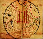
, Southwest and Central Asia receive better resolution in Muslim geography, and the 11th century map by Mahmud al-Kashgari is the first world map drawn from a Central Asian point of view. In the same period, European explorers of the Silk road
Silk Road
The Silk Road or Silk Route refers to a historical network of interlinking trade routes across the Afro-Eurasian landmass that connected East, South, and Western Asia with the Mediterranean and European world, as well as parts of North and East Africa...
like William Rubruck and Marco Polo
Marco Polo
Marco Polo was a Venetian merchant traveler from the Venetian Republic whose travels are recorded in Il Milione, a book which did much to introduce Europeans to Central Asia and China. He learned about trading whilst his father and uncle, Niccolò and Maffeo, travelled through Asia and apparently...
increase geographical knowledge of Asia in the west, in particular establishing that the Caspian Sea
Caspian Sea
The Caspian Sea is the largest enclosed body of water on Earth by area, variously classed as the world's largest lake or a full-fledged sea. The sea has a surface area of and a volume of...
is not connected to the northern ocean.
Chinese exploration
Chinese exploration
Chinese exploration includes exploratory Chinese travels abroad, on land and by sea, from the 2nd century BC until the 15th century.-Pamir Mountains and beyond:...
by medieval times extends Chinese geographical knowledge to the Indian ocean, the Arabian peninsula and East Africa as well as Southeast Asia.
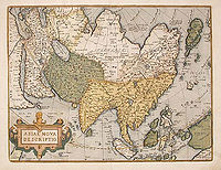
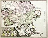
Age of exploration
European maps of Asia become much more detailed from the 15th century, the 1459 Fra Mauro mapFra Mauro map
The Fra Mauro map, "considered the greatest memorial of medieval cartography" according to Roberto Almagià, is a map made around 1450 by the Venetian monk Fra Mauro...
showing a reasonable complete picture, including correctly placed Korea and Japan.
Modern maps
The modern map making techniques in India, like other parts of the world, employ digitization, photographic surveyPhotograph
A photograph is an image created by light falling on a light-sensitive surface, usually photographic film or an electronic imager such as a CCD or a CMOS chip. Most photographs are created using a camera, which uses a lens to focus the scene's visible wavelengths of light into a reproduction of...
s and printing
Printing
Printing is a process for reproducing text and image, typically with ink on paper using a printing press. It is often carried out as a large-scale industrial process, and is an essential part of publishing and transaction printing....
. Satellite imageries
Satellite imagery
Satellite imagery consists of photographs of Earth or other planets made by means of artificial satellites.- History :The first images from space were taken on sub-orbital flights. The U.S-launched V-2 flight on October 24, 1946 took one image every 1.5 seconds...
, aerial photographs and video surveying
Video
Video is the technology of electronically capturing, recording, processing, storing, transmitting, and reconstructing a sequence of still images representing scenes in motion.- History :...
techniques are also used.
Literature
- Harley and Woodward (eds.), The History of Cartography. Vol. 2. bk 2, Cartography in Traditional East and Southeast Asian Societies, University of Chicago Press (1994), ISBN 978-0226316376.
- Kenneth Nebenzahl, Mapping the Silk Road and Beyond, ISBN 0714844098.
See also
- Geography of AsiaGeography of AsiaGeography of Asia reviews geographical concepts of classifying Asia, the central and eastern part of Eurasia, comprising approximately fifty countries.-Boundary:...
- Muslim geography
- Chinese geographyChinese geographyNative Chinese geography begins in the Warring States period . It expands its scope beyond the Chinese homeland with the growth of the Chinese Empire under the Han Dynasty...
- Chinese explorationChinese explorationChinese exploration includes exploratory Chinese travels abroad, on land and by sea, from the 2nd century BC until the 15th century.-Pamir Mountains and beyond:...
- Cartography of IndiaCartography of IndiaThe cartography of India begins with early charts for navigation and constructional plans for buildings. Indian traditions influenced Tibetan and Islamic traditions, and in turn, were influenced by the British cartographers who solidified modern concepts into India's map making.A prominent foreign...
- History of cartographyHistory of cartographyCartography , or mapmaking, has been an integral part of the human story for a long time, possibly up to 8,000 years...
- History of geographyHistory of geographyThe history of geography includes various histories of geography which have differed over time and between different cultural and political groups. In more recent developments, geography has become a distinct academic discipline. 'Geography' derives from the from Greek - geographia,, a literal...
- Exploration of Asia
- Cartography of EuropeCartography of EuropeThe earliest cartographic depictions of Europe are found in early world maps.In classical antiquity, Europe was assumed to cover the quarter of the globe north of the Mediterranean, an arrangement that was adhered to in medieval T and O maps....
- Cartography of AfricaCartography of AfricaThe earliest cartographic depictions of Africa are found in early world maps.In classical antiquity, Africa was assumed to cover the quarter of the globe south of the Mediterranean, an arrangement that was adhered to in medieval T and O maps....
- Boundaries between continents
External links
- Historical maps of Asia, Alabama Maps project of the Cartographic Research Laboratory, University of Alabama.
- Asia Historical Maps, Perry-Castañeda Library Map Collection, University of Texas, Austin.