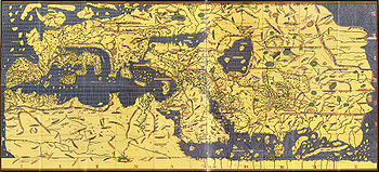
Tabula Rogeriana
Encyclopedia


Latin
Latin is an Italic language originally spoken in Latium and Ancient Rome. It, along with most European languages, is a descendant of the ancient Proto-Indo-European language. Although it is considered a dead language, a number of scholars and members of the Christian clergy speak it fluently, and...
), is a description of the world and world map
World map
A world map is a map of the surface of the Earth, which may be made using any of a number of different map projections. A map projection is any method of representing the surface of a sphere or other three-dimensional body on a plane....
created by the Arab geographer, Muhammad al-Idrisi
Muhammad al-Idrisi
Abu Abd Allah Muhammad al-Idrisi al-Qurtubi al-Hasani al-Sabti or simply Al Idrisi was a Moroccan Muslim geographer, cartographer, Egyptologist and traveller who lived in Sicily, at the court of King Roger II. Muhammed al-Idrisi was born in Ceuta then belonging to the Almoravid Empire and died in...
, in 1154. Al-Idrisi worked on the commentaries and illustrations of the map for fifteen years at the court of the Norman
Normans
The Normans were the people who gave their name to Normandy, a region in northern France. They were descended from Norse Viking conquerors of the territory and the native population of Frankish and Gallo-Roman stock...
King Roger II of Sicily
Roger II of Sicily
Roger II was King of Sicily, son of Roger I of Sicily and successor to his brother Simon. He began his rule as Count of Sicily in 1105, later became Duke of Apulia and Calabria , then King of Sicily...
, who commissioned the work around 1138.
The book, written in Arabic, is divided into seven climate zones (in keeping with the established Ptolemaic
Ptolemy
Claudius Ptolemy , was a Roman citizen of Egypt who wrote in Greek. He was a mathematician, astronomer, geographer, astrologer, and poet of a single epigram in the Greek Anthology. He lived in Egypt under Roman rule, and is believed to have been born in the town of Ptolemais Hermiou in the...
system), each of which is sub-divided into ten sections, and contains maps showing the Eurasia
Eurasia
Eurasia is a continent or supercontinent comprising the traditional continents of Europe and Asia ; covering about 52,990,000 km2 or about 10.6% of the Earth's surface located primarily in the eastern and northern hemispheres...
n continent in its entirety, but only the northern part of the Africa
Africa
Africa is the world's second largest and second most populous continent, after Asia. At about 30.2 million km² including adjacent islands, it covers 6% of the Earth's total surface area and 20.4% of the total land area...
n continent. The map is oriented with the North at the bottom. It remained the most accurate world map for the next three centuries. The text incorporates exhaustive descriptions of the physical, cultural, political and socioeconomic conditions of each region and each of the seventy sections has a corresponding map.
To produce the work al-Idrisi interviewed experienced travelers individually and in groups on their knowledge of the world and compiled "only that part... on which there was complete agreement and seemed credible, excluding what was contradictory." Roger II had his map engraved on a silver disc weighing about 300 pounds. It showed, in al-Idrisi's words, "the seven climatic regions, with their respective countries and districts, coasts and lands, gulfs and seas, watercourses and river mouths."
On the work of al-Idrisi, S. P. Scott commented:
Ten manuscript copies of the Book of Roger currently survive, five of which have complete text and eight of which have maps. Two are in the Bibliothèque nationale de France
Bibliothèque nationale de France
The is the National Library of France, located in Paris. It is intended to be the repository of all that is published in France. The current president of the library is Bruno Racine.-History:...
, including the oldest, dated to about 1325. (MS Arabe 2221). Another copy, made in Cairo in 1553, is in the Bodleian Library
Bodleian Library
The Bodleian Library , the main research library of the University of Oxford, is one of the oldest libraries in Europe, and in Britain is second in size only to the British Library...
in Oxford (Mss. Pococke 375). It was acquired in 1692. The most complete manuscript, which includes the world map and all seventy sectional maps, is kept in Istanbul.
External links
- The World Maps of al-Idrisi
- Online exhibition, Bibliothèque nationale de FranceBibliothèque nationale de FranceThe is the National Library of France, located in Paris. It is intended to be the repository of all that is published in France. The current president of the library is Bruno Racine.-History:...
(french) - View Online at the BNF (653 pages).

