

Entrada Sandstone
Encyclopedia
San Rafael Group
The San Rafael Group is a geologic group of formations that is spread across the U.S. states of New Mexico, Arizona, Utah and Colorado. Part of the Colorado Plateau, this group of formations was laid down in the Middle Jurassic during the Bajocian, Bathonian and Callovian stages. Asterisks ...
that is spread across the U.S. state
U.S. state
A U.S. state is any one of the 50 federated states of the United States of America that share sovereignty with the federal government. Because of this shared sovereignty, an American is a citizen both of the federal entity and of his or her state of domicile. Four states use the official title of...
s of Wyoming
Wyoming
Wyoming is a state in the mountain region of the Western United States. The western two thirds of the state is covered mostly with the mountain ranges and rangelands in the foothills of the Eastern Rocky Mountains, while the eastern third of the state is high elevation prairie known as the High...
, Colorado
Colorado
Colorado is a U.S. state that encompasses much of the Rocky Mountains as well as the northeastern portion of the Colorado Plateau and the western edge of the Great Plains...
, northwest New Mexico
New Mexico
New Mexico is a state located in the southwest and western regions of the United States. New Mexico is also usually considered one of the Mountain States. With a population density of 16 per square mile, New Mexico is the sixth-most sparsely inhabited U.S...
, northeast Arizona
Arizona
Arizona ; is a state located in the southwestern region of the United States. It is also part of the western United States and the mountain west. The capital and largest city is Phoenix...
and southeast Utah
Utah
Utah is a state in the Western United States. It was the 45th state to join the Union, on January 4, 1896. Approximately 80% of Utah's 2,763,885 people live along the Wasatch Front, centering on Salt Lake City. This leaves vast expanses of the state nearly uninhabited, making the population the...
. Part of the Colorado Plateau
Colorado Plateau
The Colorado Plateau, also called the Colorado Plateau Province, is a physiographic region of the Intermontane Plateaus, roughly centered on the Four Corners region of the southwestern United States. The province covers an area of 337,000 km2 within western Colorado, northwestern New Mexico,...
, this formation was deposited during the Jurassic
Jurassic
The Jurassic is a geologic period and system that extends from about Mya to Mya, that is, from the end of the Triassic to the beginning of the Cretaceous. The Jurassic constitutes the middle period of the Mesozoic era, also known as the age of reptiles. The start of the period is marked by...
period sometime between 180 and 140 million years ago in various environments, including: tidal mudflats, beaches and sand dunes.
Age and history of investigation
This formation has been dated to the early to middle CallovianCallovian
In the geologic timescale, the Callovian is an age or stage in the Middle Jurassic, lasting between 164.7 ± 4.0 Ma and 161.2 ± 4.0 Ma. It is the last stage of the Middle Jurassic, following the Bathonian and preceding the Oxfordian....
stage of the latest Middle Jurassic
Middle Jurassic
The Middle Jurassic is the second epoch of the Jurassic Period. It lasted from 176-161 million years ago. In European lithostratigraphy, rocks of this Middle Jurassic age are called the Dogger....
. The type locality
Type locality (geology)
Type locality , also called type area or type locale, is the where a particular rock type, stratigraphic unit, fossil or mineral species is first identified....
and place for which the unit is named is Entrada Point, located in the northern part the San Rafael Swell
San Rafael Swell
The San Rafael Swell is a large geologic feature located in south-central Utah, USA about 30 miles west of Green River, Utah. The San Rafael Swell, approximately by , consists of a giant dome-shaped anticline of sandstone, shale, and limestone that was pushed up during the Paleocene Laramide...
in Emery County, Utah
Emery County, Utah
Emery County is a county located in the U.S. state of Utah. As of 2000 the population was 10,860, and by 2009 had been estimated to decrease to 10,629. It was named for George W. Emery, governor of the Utah Territory in 1875...
.
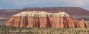
Entrada Sandstone
Sandstone
Sandstone is a sedimentary rock composed mainly of sand-sized minerals or rock grains.Most sandstone is composed of quartz and/or feldspar because these are the most common minerals in the Earth's crust. Like sand, sandstone may be any colour, but the most common colours are tan, brown, yellow,...
was named as one of the four formations of the San Rafael Group by Gilluly and Reeside in 1928. Gregory and Moore worked out the geographic extent of the formation and gave an overview of it in 1931. The extent was revised several times afterwards (most recently in 1992 by Condon). It was divided into Gunsight Butte, Cannonville, and Escalante members by Thompson and Stokes in 1970. The principal reference for the formation was written in 1988 by Peterson.
Members
Entrada members are (in alphabetical order):- Cannonville Member (UT),
- Cow Springs Member (AZ),
- Dewey Bridge Member (CO, UT) - named after the type locality at Dewey Bridge. This brick-red layer has a blocky look to it.
- Escalante Member (UT),
- Henrieville Member (UT),
- Exeter Member (NM),
- Gunsight Butte Member (UT),
- Iyanbito Member (NM),
- Moab Member (CO, UT) or Moab Tongue (CO, UT) - named after the type locality of Moab, UtahMoab, UtahMoab is a city in Grand County, in eastern Utah, in the western United States. The population was 4,779 at the 2000 census. It is the county seat and largest city in Grand County. Moab hosts a large number of tourists every year, mostly visitors to the nearby Arches and Canyonlands National Parks...
. The whitish sands from inland dunes make up this "cap rock" layer, as seen atop Delicate ArchDelicate ArchDelicate Arch is a tall freestanding natural arch located in Arches National Park near Moab, Utah.It is the most widely-recognized landmark in Arches National Park and is depicted on Utah license plates and on a postage stamp commemorating Utah's centennial anniversary of statehood in 1996...
and Broken Arch in Arches National ParkArches National ParkArches National Park is a U.S. National Park in eastern Utah. It is known for preserving over 2000 natural sandstone arches, including the world-famous Delicate Arch, in addition to a variety of unique geological resources and formations....
. - Red Mesa Member (AZ, NM, UT),
- Slick Rock Member (CO, UT) - named for the type locality at Slick Rock, ColoradoSlick Rock, ColoradoSlick Rock is an unincorporated town in San Miguel County, Colorado, United States. The U.S. Post Office at Egnar now serves Slick Rock postal addresses.- Geography :Slick Rock is located at ....
; Rounded beach sands were cemented together to create this uniform layer.
Places found
Entrada Sandstone is found in these geologic locations:Geologic province
Geologic province
A geologic or geomorphic province is a spatial entity with common geologic or geomorphic attributes. A province may include a single dominant structural element such as a basin or a fold belt, or a number of contiguous related elements...
:
- Anadarko BasinAnadarko BasinThe Anadarko Basin is a geologic depositional and structural basin centered in the western part of the state of Oklahoma and the Texas Panhandle, and extending into western Kansas and southeast Colorado.-Geology:...
- Black Mesa Basin
- Denver BasinDenver BasinThe Denver Basin, sometimes also called the Julesburg Basin, Denver-Julesburg Basin , or the D-J Basin, is a geologic structural basin centered in eastern Colorado in the United States, but extending into southeast Wyoming, western Nebraska, and western Kansas...
- Great BasinGreat BasinThe Great Basin is the largest area of contiguous endorheic watersheds in North America and is noted for its arid conditions and Basin and Range topography that varies from the North American low point at Badwater Basin to the highest point of the contiguous United States, less than away at the...
province - Green River Basin
- Las Vegas-Raton Basin
- Paradox BasinParadox BasinThe Paradox Basin is an asymmetric foreland basin located mostly in southeast Utah and southwest Colorado, but extending into northeast Arizona and northwest New Mexico. The basin is a large elongate northwest to southeast oriented depression formed during the late Paleozoic Era...
- Piceance BasinPiceance BasinThe Piceance Basin is a geologic structural basin in northwestern Colorado, in the United States. It includes geologic formations from Cambrian to Holocene in age, but the thickest section is made up of rocks from the Cretaceous Period...
- Plateau sedimentary province
- San Juan BasinSan Juan BasinThe San Juan Basin is a geologic structural basin in the Four Corners region of the Southwestern United States; its main portion covers around , encompassing much of northwestern New Mexico, southwest Colorado, and parts of Arizona and Utah....
- Sierra Grande Uplift
Found in these parklands (incomplete list):
- Arches National ParkArches National ParkArches National Park is a U.S. National Park in eastern Utah. It is known for preserving over 2000 natural sandstone arches, including the world-famous Delicate Arch, in addition to a variety of unique geological resources and formations....
- Capitol Reef National ParkCapitol Reef National ParkCapitol Reef National Park is a United States National Park, in south-central Utah. It is 100 miles long but fairly narrow. The park, established in 1971, preserves 378 mi² and is open all year, although May through September are the most popular months.Called "Wayne Wonderland" in the 1920s...
- Goblin Valley State ParkGoblin Valley State ParkGoblin Valley State Park is a state park of Utah, USA.Its eminent feature is its thousands of hoodoos and hoodoo rocks, which are formations of mushroom-shaped rock pinnacles, some as high as several meters...
- Kodachrome Basin State ParkKodachrome Basin State ParkKodachrome Basin is a state park of Utah, USA. It is situated above sea level, south of Utah Route 12, and southeast of Bryce Canyon National Park. It is accessible from the north from Cannonville by a paved road and from the south by Road 400, a dirt road from the Page, Arizona area to...
Spatial distribution:
- spatial distribution of Entrada Sandstone in Macrostrat
Works cited
- Condon, S.M., 1992, "Geologic framework of pre-Cretaceous rocks in the Southern Ute Indian Reservation and adjacent areas, southwestern Colorado and northwestern New Mexico, IN Geology and mineral resources of the Southern Ute Indian Reservation", U.S. Geological Survey Professional Paper, 1505-A, p. A1-A56
- Gilluly, James and Reeside, J.B., Jr., 1928, "Sedimentary rocks of the San Rafael Swell and some adjacent areas in eastern Utah, IN Shorter contributions to general geology", 1927: U.S. Geological Survey Professional Paper, 150-D, p. D61-D110
- Gregory, H.E. and Moore, R.C., 1931, "The Kaiparowits region, a geographic and geologic reconnaissance of parts of Utah and Arizona", U.S. Geological Survey Professional Paper, 164, 16 p.
- Peterson, Fred, 1988, "Stratigraphy and nomenclature of Middle and Upper Jurassic rocks, western Colorado Plateau, Utah and Arizona, IN Revisions to stratigraphic nomenclature of Jurassic and Cretaceous rocks of the Colorado Plateau", U.S. Geological Survey Bulletin, 1633-B, p. B13-56
- Thompson, A.E. and Stokes, W.L., 1970, "Stratigraphy of the San Rafael Group, southwest and south central Utah", Utah Geological and Mineral Survey Bulletin, no. 87, 53 p.
- USGS GEOLEX database entry for Entrada Sandstone Accessed 18 March 2006 (public domain text)