

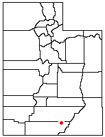
Fortymile Gulch
Encyclopedia
Escalante River
right|Location of the Escalante River within UtahThe Escalante River is a tributary of the Colorado River. It is formed by the confluence of North and Birch Creeks near the town of Escalante in south-central Utah, and from there flows southeast for approximately before joining Lake Powell...
, located in Kane County
Kane County, Utah
As of the census of 2000, there were 6,046 people, 2,237 households, and 1,628 families residing in the county. The population density was 2 people per square mile . There were 3,767 housing units at an average density of 1 per square mile...
in southern Utah
Utah
Utah is a state in the Western United States. It was the 45th state to join the Union, on January 4, 1896. Approximately 80% of Utah's 2,763,885 people live along the Wasatch Front, centering on Salt Lake City. This leaves vast expanses of the state nearly uninhabited, making the population the...
, in the western United States
United States
The United States of America is a federal constitutional republic comprising fifty states and a federal district...
. With a combined length of over 20 miles (30 km), they exhibit many of the geologic features found in the Canyons of the Escalante
Canyons of the Escalante
The Canyons of the Escalante is a collective name for the erosional landforms created by the Escalante River and its tributaries, the Escalante River Basin. Located in southern Utah in the western United States, these sandstone features include high vertical canyon walls, water pockets, narrow...
, including high vertical canyon walls, water pools, narrow slot canyons, domes, and arches. Popular recreational destinations, they are located within the Grand Staircase-Escalante National Monument
Grand Staircase-Escalante National Monument
The Grand Staircase-Escalante National Monument contains 1.9 million acres of land in southern Utah, the United States. There are three main regions: the Grand Staircase, the Kaiparowits Plateau, and the Canyons of the Escalante. President Bill Clinton designated the area as a U.S. National...
.
The headwaters of Fortymile and Willow Gulches have their origins along a 7 mile (11 km) segment of the Straight Cliffs, the eastern edge of the Kaiparowits Plateau
Kaiparowits Plateau
right|Location of the Kaiparowits Plateau within UtahThe Kaiparowits Plateau is a large, elevated landform located in southern Utah, in the southwestern United States. Along with the Grand Staircase and the Canyons of the Escalante, it makes up a significant portion of the Grand...
. Intermittent streams merge to form larger branches, then combine to carve a deep canyon
Canyon
A canyon or gorge is a deep ravine between cliffs often carved from the landscape by a river. Rivers have a natural tendency to reach a baseline elevation, which is the same elevation as the body of water it will eventually drain into. This forms a canyon. Most canyons were formed by a process of...
up to 500 feet (150 m) into sandstone layers before meeting the main channel of the Escalante River. The northernmost branch is Fortymile Gulch, the historic location of the winter encampment of the San Juan Expedition
San Juan Expedition
right|Route of the San Juan Expedition through UtahThe San Juan Expedition was a group of Mormon settlers intent on establishing a colony in what is now southeastern Utah, in the western United States...
. Intent on founding a colony in southeastern Utah, they waited at Fortymile Springs in late 1879 while a smaller group prepared a perilous route down to the Colorado River
Colorado River
The Colorado River , is a river in the Southwestern United States and northwestern Mexico, approximately long, draining a part of the arid regions on the western slope of the Rocky Mountains. The watershed of the Colorado River covers in parts of seven U.S. states and two Mexican states...
at Hole-in-the-Rock
Hole in the Rock (road)
Hole in the Rock is a narrow and steep crevice in the western rim of Glen Canyon, in southern Utah in the western United States. Together with another canyon on the eastern side of the Colorado River, it provided a route through what would otherwise be a large area of impassible terrain.In the...
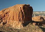
. Nearby is Dance Hall Rock, a scenic dome formed from Entrada sandstone
Entrada Sandstone
The Entrada Sandstone is a formation in the San Rafael Group that is spread across the U.S. states of Wyoming, Colorado, northwest New Mexico, northeast Arizona and southeast Utah...
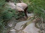
. The lower section of Fortymile Gulch, before it merges with Willow Gulch, is a narrow channel of slot canyon
Slot canyon
A slot canyon is a narrow canyon, formed by the wear of water rushing through rock. A slot canyon is significantly deeper than it is wide. Some slot canyons can measure less than one metre across at the top but drop more than 30 m to the floor of the canyon.Most slot canyons are formed in...
s and water pools
Plunge pool
A plunge pool can be a natural hydrologic fluvial landform feature or a constructed recreational garden feature...
.
Hole in the Rock Road
The Hole in the Rock Trail is a historic road running west of the Escalante River in southern Utah in the western United States. Running almost from near Escalante to Bluff, it travels within the borders of the Grand Staircase-Escalante National Monument and the adjacent Glen Canyon National...
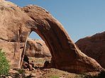
. Approximately one mile downstream is the spectacular Broken Bow Arch, named after a Native American
Native Americans in the United States
Native Americans in the United States are the indigenous peoples in North America within the boundaries of the present-day continental United States, parts of Alaska, and the island state of Hawaii. They are composed of numerous, distinct tribes, states, and ethnic groups, many of which survive as...
artifact found nearby. The opening is estimated at 94 feet (29 m) wide and 100 feet (30 m) high, demonstrating the arch
Natural arch
A natural arch or natural bridge is a natural geological formation where a rock arch forms, with an opening underneath. Most natural arches form as a narrow ridge, walled by cliffs, become narrower from erosion, with a softer rock stratum under the cliff-forming stratum gradually eroding out until...
-forming ability of Navajo sandstone
Navajo Sandstone
Navajo Sandstone is a geologic formation in the Glen Canyon Group that is spread across the U.S. states of northern Arizona, northwest Colorado, and Utah; as part of the Colorado Plateau province of the United States...
. Downstream from there the canyon passes through a deep pool of water in a narrow slot canyon, merges with the main branch of Fortymile Gulch and two tributaries draining from the north, and then proceeds down to the Escalante River. Much of this lower section may now be under the surface of Lake Powell
Lake Powell
Lake Powell is a huge reservoir on the Colorado River, straddling the border between Utah and Arizona . It is the second largest man-made reservoir in the United States behind Lake Mead, storing of water when full...
, depending on the level of the reservoir behind the Glen Canyon Dam
Glen Canyon Dam
Glen Canyon Dam is a concrete arch dam on the Colorado River in northern Arizona in the United States, just north of Page. The dam was built to provide hydroelectricity and flow regulation from the upper Colorado River Basin to the lower. Its reservoir is called Lake Powell, and is the second...
.
| |
||||||||
 |
 |
 |
||||||
| Streambed | Sooner Rocks | Canyon Walls | ||||||