

Bundjalung Nation Timeline
Encyclopedia
Bundjalung
The Bundjalung people are a large Aboriginal nation, a federation of a number of groups of clans which occupy the land from GraftonGrafton, New South Wales
The city of Grafton is the commercial hub of the Clarence River Valley. Established in 1851, Grafton features many historic buildings and tree-lined streets. Located approximately 630 kilometres north of Sydney and 340 km south of Brisbane, Grafton and the Clarence Valley can be reached...
on the Clarence river
Clarence River (New South Wales)
The Clarence River is situated in northeastern New South Wales, Australia. The river originates on the watershed that marks the Queensland border. After flowing south and northeast for 394 km it then empties into the Pacific Ocean at Iluka/Yamba. On its journey it passes through the towns of...
of northern New South Wales north to the town of Ipswich
Ipswich
Ipswich is a large town and a non-metropolitan district. It is the county town of Suffolk, England. Ipswich is located on the estuary of the River Orwell...
and the Beaudesert
Beaudesert, Queensland
Beaudesert is a town located on the Mount Lindesay Highway, some 64 km south of Brisbane. It is possibly named after Beau Desert Park, the property of Charles Henry Alexander Paget, 6th Marquess of Anglesey in Staffordshire, England...
, in southern Queensland, and down around the other side of the Great Dividing Range
Great Dividing Range
The Great Dividing Range, or the Eastern Highlands, is Australia's most substantial mountain range and the third longest in the world. The range stretches more than 3,500 km from Dauan Island off the northeastern tip of Queensland, running the entire length of the eastern coastline through...
and back to Grafton. In the north, Bundjalung Nation shares a border with Yuggera Nation and Barrunggam Nation; to the east the Tasman Sea
Tasman Sea
The Tasman Sea is the large body of water between Australia and New Zealand, approximately across. It extends 2,800 km from north to south. It is a south-western segment of the South Pacific Ocean. The sea was named after the Dutch explorer Abel Janszoon Tasman, the first recorded European...
(Pacific Ocean
Pacific Ocean
The Pacific Ocean is the largest of the Earth's oceanic divisions. It extends from the Arctic in the north to the Southern Ocean in the south, bounded by Asia and Australia in the west, and the Americas in the east.At 165.2 million square kilometres in area, this largest division of the World...
); to the south Gumbainggari (also known as Gumbainggin) Nation; and to the west it borders Ngarabal Nation.
In pre-colonial
Colony
In politics and history, a colony is a territory under the immediate political control of a state. For colonies in antiquity, city-states would often found their own colonies. Some colonies were historically countries, while others were territories without definite statehood from their inception....
times, Bundjalung Nation encompassed some of the richest hunting and fishing grounds anywhere on the Australian continent. According to the oral traditions of the Bundjalung People, these areas were first settled by the Three Brothers and their descendants.
The names of the 15 tribal groups comprising the Bundjalung Nation are Aragwal, Banbai, Birbai, Galiabal, Gidabal, Gumbainggeri, Jigara, Jugambal, Jugumbir, Jungai, Minjungbal, Ngacu, Ngamba, Thungutti and Widjabal.
The 2007 Githabul Federal Court Native Title Determination which was lodged by Trevor Close a commercial lawyer now living in Perth cut the Bundjalung Nation apart can be viewed here.
To the best of knowledge the Bundjalung Nation Aboriginal people from the East Coast of Australia, the Far North Coast of New South Wales and South East Queensland area, are the only ones whose dream time stories talk about arriving in Australia from elsewhere. They came from the land "at the centre of the world" when a massive catastrophe destroyed it.
Bundjalung Nation Aboriginal people have lived on and visited Goanna Headland for at least 12,000 years. The Aboriginal tribes were not united anytime before the 18th century, with more than 20 main groups, known collectively as the 'Bundjalung Nation'. Certain deities and religious practices were specific to certain localities.
Goanna Headland is also significant as the site where the ancestors of the Bundjalung people arrived by sea and populated the surrounding country. This event is related through the legend of "The Three Brothers (Bundjalung Nation) ".
European Discovery
On 15 May 1770, the coast in the vicinity of Evans Head was first mapped and described by Lieutenant James CookJames Cook
Captain James Cook, FRS, RN was a British explorer, navigator and cartographer who ultimately rose to the rank of captain in the Royal Navy...
(also known as Captain Cook FRS
Royal Society
The Royal Society of London for Improving Natural Knowledge, known simply as the Royal Society, is a learned society for science, and is possibly the oldest such society in existence. Founded in November 1660, it was granted a Royal Charter by King Charles II as the "Royal Society of London"...
RN
Royal Navy
The Royal Navy is the naval warfare service branch of the British Armed Forces. Founded in the 16th century, it is the oldest service branch and is known as the Senior Service...
) on the (also known as His Majesty's Bark the Endeavour or HMS Bark Endeavour, a Royal Navy of the United Kingdom research vessel
Research vessel
A research vessel is a ship designed and equipped to carry out research at sea. Research vessels carry out a number of roles. Some of these roles can be combined into a single vessel, others require a dedicated vessel...
commanded by Lieutenant James Cook on his first voyage of discovery, to Australia and New Zealand from 1769 to 1771). Cook spent only one day in the area and did not land on the mainland but the next day on 16 May, Cook named Cape Byron
Cape Byron
Cape Byron is the easternmost point of the mainland of Australia. It is located about northeast of the town of Byron Bay and projects into the Pacific Ocean...
and Mount Warning
Mount Warning
Mount Warning is a mountain west-south-west of Murwillumbah, near the border with Queensland in the Northern Rivers region of New South Wales, Australia...
(or Wollumbin), after seeing the mountain from the sea while sailing past.
Lieutenant James Cook failed to notice the entrance to the Richmond River
Richmond River
The Richmond River is a river in the north-eastern corner of New South Wales, Australia. It runs for approximately 170 km from the foothills of the Border Ranges past the towns of Kyogle, Casino, Coraki, Woodburn, where it turns northward and empties into the Pacific Ocean at Ballina. It has a...
on 15 May 1770, but noted the presence of about 20 Bundjalung Nation Aboriginal people on what is now Seven Mile Beach, just to the south of Broken Head. Sir Joseph Banks
Joseph Banks
Sir Joseph Banks, 1st Baronet, GCB, PRS was an English naturalist, botanist and patron of the natural sciences. He took part in Captain James Cook's first great voyage . Banks is credited with the introduction to the Western world of eucalyptus, acacia, mimosa and the genus named after him,...
also noted these people and remarked that they completely ignored the presence of the HMS Endeavour
HMS Endeavour
HMS Endeavour may refer to one of the following ships:In the Royal Navy:, a 36-gun ship purchased in 1652 and sold in 1656, a 4-gun bomb vessel purchased in 1694 and sold in 1696, a fire ship purchased in 1694 and sold in 1696, a storeship hoy purchased in 1694 and sold in 1705, a storeship...
. This would seem to indicate that the HMS Endeavour was not the first ship that they had seen (Richmond River Historical Society {RRHS}, 1997).
On August 20, 1828 Captain Henry John Rous
Henry John Rous
Admiral Henry John Rous was a Royal Navy officer and sportsman.-Career:Born the second son of John Rous, 1st Earl of Stradbroke, Rous was educated at Westminster School, and entered the Royal Navy in 1808, serving as a midshipman in the Walcheren Campaign the following year...
on the frigate dropped anchor at Byron Bay. His mission was to discover a navigable river and safe anchorage site. On August 26, 1828 Captain Henry John Rous on the frigate HMS Rainbow discovers the entrance to the Richmond River
Richmond River
The Richmond River is a river in the north-eastern corner of New South Wales, Australia. It runs for approximately 170 km from the foothills of the Border Ranges past the towns of Kyogle, Casino, Coraki, Woodburn, where it turns northward and empties into the Pacific Ocean at Ballina. It has a...
(the longest navigable river on the coast of NSW) and explores 32 kilometers up the river with two lieutenants in a Pinnace, as far as Tuckean Swamp. Captain Henry John Rous subsequently named the river Richmond after his brother's best friend, Charles Gordon-Lennox
Charles Gordon-Lennox, 5th Duke of Richmond
Charles Gordon-Lennox, 5th Duke of Richmond and 5th Duke of Lennox KG, PC , styled Earl of March until in 1819, was a British soldier, politician and a prominent Conservative.-Background and education:...
, 5th Duke of Richmond KG
Order of the Garter
The Most Noble Order of the Garter, founded in 1348, is the highest order of chivalry, or knighthood, existing in England. The order is dedicated to the image and arms of St...
, PC (3 August 1791 – 21 October 1860).
European Settlement
The beginning of white settlement into the Richmond River area was the result of early explorations into the region by red cedar cutters and farmers, who arrived in approximately 1842, after hearing stories from 'stray natives' of the great Wudgie-Wudgie (Red Cedar) in the Richmond river area to the north of the Clarence river.Red cedar getters, as obsessed by ‘red gold’ as those who later suffered ‘gold fever’, brooked no interference in their quest for the magnificent old trees.
In order to legally cut red cedar, cutters were required to obtain a cedar cutter's license from Grafton
Grafton, New South Wales
The city of Grafton is the commercial hub of the Clarence River Valley. Established in 1851, Grafton features many historic buildings and tree-lined streets. Located approximately 630 kilometres north of Sydney and 340 km south of Brisbane, Grafton and the Clarence Valley can be reached...
(& later Casino
Casino
In modern English, a casino is a facility which houses and accommodates certain types of gambling activities. Casinos are most commonly built near or combined with hotels, restaurants, retail shopping, cruise ships or other tourist attractions...
), issued by Commissioner Oliver Fry for the North Creek and Emigrant Creek scrubs in 1851, for 6 pounds. The license did not provide ownership to land, but did allow the cedar-getter to build a hut and cut cedar on unsettled land. Word rapidly spread about the wonderful red cedar timber which made small fortunes for the men of the Richmond River.
Timeline
| Date | Events | |
|---|---|---|
| 10,000 BC | Aboriginal ancestors of the Bundjalung Nation people arrived by sea at the mouth of the Clarence river Clarence River Clarence River may refer to:* Clarence River , in northern New South Wales, Australia* Clarence River , rises in the Yukon Territory of Canada and crosses the border several times into the U.S. state of Alaska... and populated the surrounding country. This event is related through the legend of "The Three Brothers (Bundjalung Nation)." The minimum time depth by which this migration had taken place is confirmed at 12,000 years ago, with the upper bound (or earliest period) remaining a matter of some unresolved contention. |
Details Bundjalung Nation - Bundjalung language :Bundjalung belongs to the Pama–Nyungan family of Australian Aboriginal languages. ‘Bundjalung’ has been used as a general term for the whole language and also as a term to refer to certain individual dialects... |
| 4000 BC | As the ice caps melted at the end of the Pleistocene Epoch about 12,000 years ago (10,000 BC), sea levels rose and covered a strip of land off the east coast of Australia, leaving high relief terrain exposed as a coastal promontory Promontory Promontory may refer to:*Promontory, a prominent mass of land which overlooks lower lying land or a body of water*Promontory, Utah, the location where the United States first Transcontinental Railroad was completed... . Coastal campsites used before the sea stabilised around 6,000 years ago (4000 BC), lie beneath the sea. |
Details |
| 1650 AD | In Bundjalung National Park at an Aboriginal midden on the banks of the Evans River, is a Western Kurrajong Kurrajong Kurrajong may refer to* Any of several species of Australian trees in the genus Brachychiton;* The plant species Hibiscus tiliaceus;* Kurrajong, New South Wales, a town in the Blue Mountains.... tree that is estimated to be more than 360 years old. The Marriage Tree as it is called by Bundjalung Aboriginals, was a gift from the Wahlubal tribe at Tabulam, when a wedding took place at Gummigurrah between a man and a woman. Gummigurrah was the winter campsite for Bundjalung people.The midden site is close to a camping ground. |
Details |
| May 1770 AD | Victoria Park Nature Reserve Victoria Park Nature Reserve Victoria Park Nature Reserve is a 17.5 hectare sub tropical jungle remnant of the Big Scrub. Situated on an undulating high rainfall plain near Alstonville, New South Wales. The red-brown soil is derived from a basaltic flow from the nearby Mount Warning. 8 hectares of the reserve is original... is a 17.5 hectare sub tropical jungle remnant of the Big Scrub Big Scrub The Big Scrub was the largest area of subtropical lowland rainforest in eastern Australia. It was intensively cleared for agricultural use in the 19th century by colonists... which once covered most of the district, situated 16 kilometres south-east of Lismore, it features the remnants of a gigantic Moreton Bay Fig Moreton Bay Fig Ficus macrophylla, commonly known as the Moreton Bay Fig, is a large evergreen banyan tree of the Moraceae family that is a native of most of the eastern coast of Australia, from the Atherton Tableland in the north to the Illawarra in New South Wales, and Lord Howe Island. Its common name is... tree, which was seen by Lieutenant James Cook James Cook Captain James Cook, FRS, RN was a British explorer, navigator and cartographer who ultimately rose to the rank of captain in the Royal Navy... FRS Royal Society The Royal Society of London for Improving Natural Knowledge, known simply as the Royal Society, is a learned society for science, and is possibly the oldest such society in existence. Founded in November 1660, it was granted a Royal Charter by King Charles II as the "Royal Society of London"... RN Royal Navy The Royal Navy is the naval warfare service branch of the British Armed Forces. Founded in the 16th century, it is the oldest service branch and is known as the Senior Service... as he sailed up the east coast of Australia on the . The tree was struck by lightening in the early 1980s, but today people can walk around its base and marvel at its size. |
Details Victoria Park Nature Reserve Victoria Park Nature Reserve is a 17.5 hectare sub tropical jungle remnant of the Big Scrub. Situated on an undulating high rainfall plain near Alstonville, New South Wales. The red-brown soil is derived from a basaltic flow from the nearby Mount Warning. 8 hectares of the reserve is original... |
| 15 May 1770 AD | 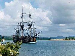 |
Details HMS Endeavour HMS Endeavour may refer to one of the following ships:In the Royal Navy:, a 36-gun ship purchased in 1652 and sold in 1656, a 4-gun bomb vessel purchased in 1694 and sold in 1696, a fire ship purchased in 1694 and sold in 1696, a storeship hoy purchased in 1694 and sold in 1705, a storeship... |
| 15 May 1770 AD | 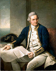 |
Details |
| 15 May 1770 AD | '... not one was once observed to stop and look toward the ship; they pursued their way in all appearance entirely unmoved by the neighbourhood of so remarkable an object as a ship must necessarily be to people who have never seen one.' This would seem to indicate that the HMS Endeavour was not the first ship that they had seen (Richmond River Historical Society {RRHS}, 1997). |
Details |
| 16 May 1770 AD | 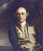 Cape Byron Cape Byron is the easternmost point of the mainland of Australia. It is located about northeast of the town of Byron Bay and projects into the Pacific Ocean... , in honour of Vice-Admiral The Hon. John 'Foulweather Jack' Byron John Byron Vice Admiral The Hon. John Byron, RN was a Royal Navy officer. He was known as Foul-weather Jack because of his frequent bad luck with weather.-Early career:... RN (November 8, 1723 – April 10, 1786), another British navigator, and grandfather of Lord Byron (22 January 1788 – 19 April 1824). Cook also noted a pair of small islands, naming the two main peaks Julian Rocks Julian Rocks Julian Rocks is a pair of small islands, surrounded by marine reserve 2.5 kilometers offshore from Byron Bay.According to a story from the Bundjalung people, a jealous husband threw his spear at the canoe of his wife and her lover. The canoe broke in two and sank to the bottom of the ocean... after his nephew and niece, Juan and Julia. Lieutenant James Cook James Cook Captain James Cook, FRS, RN was a British explorer, navigator and cartographer who ultimately rose to the rank of captain in the Royal Navy... FRS RN, was the first European to record in his diary of seeing “… a remarkable sharp peaked Mountain lying inland…” from a point of land he named Cape Byron. Just five hours later while sailing North, Cook was forced to change course to the East after encountering the dangerous reefs that run 3 miles (4.8 km) to the East from Fingal Head, now named Danger Reefs (comprising Inner, South, and Outer reefs). |
Details John Byron Vice Admiral The Hon. John Byron, RN was a Royal Navy officer. He was known as Foul-weather Jack because of his frequent bad luck with weather.-Early career:... |
| 17 May 1770 AD | 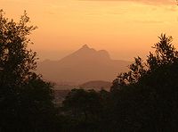 Mount Warning Mount Warning is a mountain west-south-west of Murwillumbah, near the border with Queensland in the Northern Rivers region of New South Wales, Australia... (Wulambiny Momoli) was named by Lieutenant James Cook FRS RN as a warning to other seafarers, of the numerous treacherous reefs along the New South Wales north coast, after seeing the mountain from the sea while sailing past. Lieutenant James Cook FRS RN, did not know that the Bundjalung people for many miles around called the mountain 'Wulambiny Momoli', and that it was an important sacred site, as their lives and religion were strongly linked to the land. Lieutenant James Cook FRS RN on the Endeavour recorded in his diary in the morning:
|
Details |
| 20 August 1828 AD | Captain Henry John Rous Henry John Rous Admiral Henry John Rous was a Royal Navy officer and sportsman.-Career:Born the second son of John Rous, 1st Earl of Stradbroke, Rous was educated at Westminster School, and entered the Royal Navy in 1808, serving as a midshipman in the Walcheren Campaign the following year... , also known as Admiral Henry John Rous (23 January 1795 – 19 June 1877), on the frigate dropped anchor at Byron Bay. His mission was to discover a navigable river and safe anchorage site. Rous identified the mouth of the Richmond river as he sailed along the coast from Sydney Town to Moreton Bay. |
Details Henry John Rous Admiral Henry John Rous was a Royal Navy officer and sportsman.-Career:Born the second son of John Rous, 1st Earl of Stradbroke, Rous was educated at Westminster School, and entered the Royal Navy in 1808, serving as a midshipman in the Walcheren Campaign the following year... |
| 26 August 1828 AD | 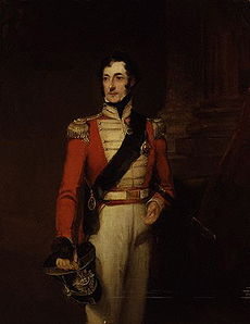 Richmond River The Richmond River is a river in the north-eastern corner of New South Wales, Australia. It runs for approximately 170 km from the foothills of the Border Ranges past the towns of Kyogle, Casino, Coraki, Woodburn, where it turns northward and empties into the Pacific Ocean at Ballina. It has a... (the longest navigable river on the coast of NSW) and explores 32 kilometers up the river with two lieutenants in a Pinnace Pinnace (ship's boat) As a ship's boat the pinnace is a light boat, propelled by sails or oars, formerly used as a "tender" for guiding merchant and war vessels. In modern parlance, pinnace has come to mean a boat associated with some kind of larger vessel, that doesn't fit under the launch or lifeboat definitions... , as far as Tuckean Swamp. Captain Henry John Rous subsequently named the river Richmond after his brother's best friend, Charles Gordon-Lennox Charles Gordon-Lennox, 5th Duke of Richmond Charles Gordon-Lennox, 5th Duke of Richmond and 5th Duke of Lennox KG, PC , styled Earl of March until in 1819, was a British soldier, politician and a prominent Conservative.-Background and education:... , 5th Duke of Richmond KG Order of the Garter The Most Noble Order of the Garter, founded in 1348, is the highest order of chivalry, or knighthood, existing in England. The order is dedicated to the image and arms of St... , PC (3 August 1791 – 21 October 1860). |
Details Charles Gordon-Lennox, 5th Duke of Richmond Charles Gordon-Lennox, 5th Duke of Richmond and 5th Duke of Lennox KG, PC , styled Earl of March until in 1819, was a British soldier, politician and a prominent Conservative.-Background and education:... |
| 1839 AD |  "where there is a violent death in consequence of a collision with white men, an Inquest or Inquiry is to be held in the same way as if the Deceased had been of European origin". |
Details |
| 1839 AD | Originally, Tabulam and the surrounding farm and bushland was inhabited by Bundjalung Nation Aboriginal people. The land was first settled by Europeans in 1839. |
Details |
| 1840 AD |  Cassino Cassino is a comune in the province of Frosinone, Italy, at the southern end of the region of Lazio.Cassino is located at the foot of Monte Cairo near the confluence of the Rapido and Liri rivers... " (Now known as the town of Casino Casino, New South Wales Casino is a town in the Northern Rivers area of New South Wales, Australia, with a population of 9,400 people . It lies on the banks of the Richmond River and is situated at the junction of the Bruxner Highway and the Summerland Way.... ) which was named after the beautiful town of Monte Cassino in Italy. Prior to European settlement the Casino district was part of the lands inhabited by the Bundjalung Aborigines. It is unclear how many of the group lived around Casino although one report, dating from 1840, talks about a gathering of a 'mob of wild blacks numbering five hundred or upwards'. The Bundjalung spread across the area and their territory reached as far north as Toowoomba and included the modern-day towns of Tenterfield and Warwick. One of the annual rituals of the Bundjalung people was the movement to the coast during the winter months when the mullet were plentiful. The inland peoples from around Casino brought black bean seeds with them to trade for the fish. The seeds are poisonous, but become edible when carefully prepared by pounding into flour, leaching with water, and roasting. The timber, which somewhat resembles walnut, is soft, fine-grained, and takes a good polish, but is not durable. The Black Bean or Moreton Bay Chestnut (Castanospermum Castanospermum Castanospermum australe , the only species in the genus Castanospermum, is a flowering plant in the family Fabaceae, native to the east coast of Australia in Queensland and New South Wales, and to the Pacific islands of Vanuatu and New Caledonia.-Growth:It is a large evergreen tree growing to ... australe) has proved valuable to Europeans as a timber species, it's seeds have been utilized - following extensive preparation as a food by Aborigines and it contains alkaloids which have been shown to have anti-HIV and anti-cancer properties. |
Details Casino, New South Wales Casino is a town in the Northern Rivers area of New South Wales, Australia, with a population of 9,400 people . It lies on the banks of the Richmond River and is situated at the junction of the Bruxner Highway and the Summerland Way.... |
| 1841 AD | On the 11th August 1841 Oliver Fry was appointed the first commissioner of Crown Lands for the Clarence Squatting District, incorporating the Clarence, Richmond and Tweed Valleys. It was his decision not to officially record Aboriginal culture of the region. Fry was instructed to 'gain confidence and goodwill' of the Bundjalung Nation Aboriginals in the 'pursuit of civilised life', and he was involved in at least one known massacre of Dangaddi or Gumbainggari aboriginal people in 1845, in the Boyd River Region of Oxley Wild Rivers National Park Oxley Wild Rivers National Park Oxley Wild Rivers National Park is in New South Wales, Australia, 445 kilometres north of Sydney and is named in memory of the Australian explorer John Oxley, who passed through the area in 1818... , along the Old Glen Innes to Grafton Highway in North East NSW. It is said that the Clarence River Aboriginals in their primitive state were remarkably moral, and most rigid in the observance of their marriage and other laws. |
Details |
| 1842 AD | The beginning of European settlement into the Richmond River area by Red Cedar Toona ciliata Australian Red Cedar , Toona ciliata is a forest tree in the family Meliaceae which grows throughout southern Asia from Afghanistan to Papua New Guinea and Australia. In Australia its natural habitat is now extensively cleared subtropical rainforests of New South Wales and Queensland... cutters (lumbermen) and farmers (pastoralists).  Supplies of mild European antiseptics were scarce and had limited effect on serious infections and fungal diseases. The indigenous native Bundjalung Nation Aboriginals of eastern Australia exposed to the same harsh conditions with little or no protection were observed crushing tea tree leaf and binding it over wounds and infections with paper bark strapping. The results were staggering, infection was controlled and wounds healed rapidly. Botanists soon identified this unique medicinal tree and created the botanical species Melaleuca alternifolia Melaleuca alternifolia Melaleuca alternifolia, commonly known as Narrow-leaved Paperbark, Narrow-leaved Tea-tree, Narrow-leaved Ti-tree, or Snow-in-summer, is a species of tree or tall shrub in the plant genus Melaleuca. Native to Australia, it occurs on the north coast and adjacent ranges of New South Wales... . In addition, the indigenous native Bundjalung Nation Aboriginal people used “tea trees Melaleuca alternifolia Melaleuca alternifolia, commonly known as Narrow-leaved Paperbark, Narrow-leaved Tea-tree, Narrow-leaved Ti-tree, or Snow-in-summer, is a species of tree or tall shrub in the plant genus Melaleuca. Native to Australia, it occurs on the north coast and adjacent ranges of New South Wales... ” as a traditional medicine by inhaling the oils from the crushed leaves to treat coughs and colds. Furthermore, tea tree leaves are soaked to make an infusion to treat sore throats or skin ailments. Historically ‘Bungawalbyn Valley Basin’ is the birthplace of the 'TEA TREE INDUSTRY' and over a period of time world populations were introduced to this unique ‘natural’ antiseptic. Still to this day, modern science has failed to provide a safe effective medication for the treatment of topical infections and fungal diseases compared to ‘Australian Native Tea Tree Oil'. |
Details Tea tree oil Tea tree oil, or melaleuca oil, is a pale yellow colour to nearly clear essential oil with a fresh camphoraceous odor. It is taken from the leaves of the Melaleuca alternifolia, which is native to the northeast coast of New South Wales, Australia... |
| 1842 AD | PELICAN CREEK TRAGEDY: In 1842, five European men were killed at Pelican Creek which is a few kilometers north of Coraki, which lead to 100 Bundjalung Nation Aboriginal tribes people being massacred by way of reprisal at Evans Head. |
Details |
| 1842 AD | EVANS HEAD MASSACRE: The Evans Head Massacre which led to the deaths of approximately 100 Bundjalung Nation tribes people by Europeans at Evans Head, was said by Aboriginals to have been in retaliation for the killing of 'a few sheep', or was said by Europeans to have been for the killing of 'five European men' from the 1842 'Pelican Creek Tragedy'. |
Details |
| 1843 AD |  |
Details Ballina, New South Wales Ballina is a town on the Northern Rivers of New South Wales, Australia, and the seat of the Ballina Shire Local Government Area. It had a population of 16,477 in the 2006 Census.-Location:... |
| 1843 AD | European History of Lismore begins in c.1843. The original sheep run in what is now the Lismore area was located on the north arm of the Richmond River, and the station covered 23000 acres (93.1 km²), taken up by Captain Dumaresq around 1843. The sheep which were herded down from New England found the wetter sub-tropical climate not to their liking, and the losses caused by fluke, foot rot and other diseases led to the abandonment of the run. In January 1845, William and Jane Wilson took over the run, and named it Lismore, after a small island in a loch in the Scottish Highlands. They built a house at the far northern corner of the run within twelve months of arrival, and a second house by 1851 near the corner of the present Ballina and Molesworth Streets, which was known as Lismore House. Unfortunately, neither house survives. The Wilsons, however, were commemorated in 1976 by the re-naming of the north arm of the Richmond River as Wilson River. |
Details Lismore, New South Wales Lismore is a subtropical town in northeastern New South Wales, Australia. Lismore is the main population centre in the City of Lismore local government area. Lismore is a regional centre in the Northern Rivers region of the State.-History:... |
| 1849 AD | The village of Coraki was founded by William Yabsley. |
Details |
| 1853/4 AD | EAST BALLINA MASSACRE: The Native Mounted Police were formed in 1848 in New South Wales. The Mounted Police members were from subdued Aboriginal tribes and were under the command of European Officers. The Native Mounted Police enforced European law on Aboriginal tribes with which they had no bonds. In 1853-4, at an area close to the present day East Ballina Ballina, New South Wales Ballina is a town on the Northern Rivers of New South Wales, Australia, and the seat of the Ballina Shire Local Government Area. It had a population of 16,477 in the 2006 Census.-Location:... Golf Course, the Native Police slaughtered at least 30 - 40 Bundjalung Nation Arakwal Aboriginal men, women and children while they slept. It was believed by Native Mounted Police that some Aborigines from north of the Tweed River Tweed River (New South Wales) The Tweed River is a short river in the Northern Rivers region of New South Wales, Australia. Its drainage basin consists mostly of the erosion caldera of the Tweed Volcano, a huge extinct volcano of which Mount Warning is the volcanic plug... had murdered some Europeans and that the murderers had fled south towards the Richmond River Richmond River The Richmond River is a river in the north-eastern corner of New South Wales, Australia. It runs for approximately 170 km from the foothills of the Border Ranges past the towns of Kyogle, Casino, Coraki, Woodburn, where it turns northward and empties into the Pacific Ocean at Ballina. It has a... . On the night prior to the raid, the Mounted Police stayed at James Ainsworth's father's Public House, 'The Sailor's Home'. That is, the European troopers stayed in the Hotel while the native Aboriginal trackers Tracking (hunting) Tracking in hunting and ecology is the science and art of observing animal tracks and other signs, with the goal of gaining understanding of the landscape and the animal being tracked... stayed outside the Hotel. The Native Mounted Police patrol neither disclosed the purpose of their mission nor made any inquiries about the incident. At 3 am the next morning the Native Mounted Police patrol rode out to where between 200 to 300 Bundjalung Nation Arakwal Aboriginal tribes people lay asleep in camp. The Arakwal East Ballina clan had a camping ground on the slope of the hill facing the valley near Black Head. The troopers and trackers surrounded the Bundjalung Nation Arakwal Aboriginal camp and opened fire at close range. Aboriginal men, women and children of the Bundjalung Nation Arakwal East Ballina clan were slaughtered. After the carnage, the Native Mounted Police patrol then headed north towards the Tweed River. The European settlers of East Ballina were disturbed by the unprovoked attack on the friendly natives. They reported the massacre to the NSW Government and urged it to take action. The NSW Government took no action against the perpetrators and told the Europeans settlers ‘to mind their own business and warned that persistence in the matter might lead to trouble for them', hence there are no official records of the massacres. When the Aboriginal survivors eventually returned to the camp, they sought no reprisals and took no revenge against the Native Mounted Police involved in the massacre. There is also strong oral tradition amongst the Bundjalung Aboriginal community that a massacre occurred in the 1850s at an old campsite at East Ballina. The oral tradition includes stories of escape, of people who were shot and were laid to rest in the forests north of the camp, and of those who were driven off the cliff at Black Head. There is a belief that some victims of the massacre were never buried, their bodies being either dumped off the cliff at Black Head or abandoned on Angels Beach. |
Details |
| 1860's AD | SOUTH BALLINA POISONING: The South Ballina Ballina, New South Wales Ballina is a town on the Northern Rivers of New South Wales, Australia, and the seat of the Ballina Shire Local Government Area. It had a population of 16,477 in the 2006 Census.-Location:... clan of the Arakwal people were a tribe, sub-group or estate group of the Bundjalung Nation, numbering about 200 people during the early development of Ballina township. During the early 1860s a mass poison attempt was made. Poisoned flour was given to the Bundjalung Nation Arakwal Aboriginal people to make damper Damper (food) Damper is a traditional Australian soda bread prepared by swagmen, drovers, stockmen and other travelers. It consists of a wheat flour based bread, traditionally baked in the coals of a campfire. Damper is an iconic Australian dish... . The Arakwal Aboriginal people took it to their camp at South Ballina for preparation & cooking. The old people and children of the Arakwal tribe refused to eat the damper as it was a new food. Upon waking the next morning, survivors of the Arakwal tribe found nearly 150 adults dead. |
Details |
| 1882 AD | New Italy Settlement: Perhaps the most interesting of all the developments around the town of Rocky Mouth (now called Woodburn by European Settlers and was known by Bundjalung Aboriginals as 'Maniworkan') occurred in 1882 when a number of Italians settled near Woodburn. 'In 1880, the ill-fated Marquis de Rays Marquis de Rays Charles Marie Bonaventure du Breil, Marquis de Rays was a French nobleman who had ambitions of starting a great French colony in the South Pacific... expedition of 340 hopeful migrants from Veneto Veneto Veneto is one of the 20 regions of Italy. Its population is about 5 million, ranking 5th in Italy.Veneto had been for more than a millennium an independent state, the Republic of Venice, until it was eventually annexed by Italy in 1866 after brief Austrian and French rule... , Italy Italy Italy , officially the Italian Republic languages]] under the European Charter for Regional or Minority Languages. In each of these, Italy's official name is as follows:;;;;;;;;), is a unitary parliamentary republic in South-Central Europe. To the north it borders France, Switzerland, Austria and... , sailed to make a new home in New Ireland New Ireland (island) New Ireland is a large island in Papua New Guinea, approximately 7,404 km² in area. It is the largest island of the New Ireland Province, lying northeast of the island of New Britain. Both islands are part of the Bismarck Archipelago, named after Otto von Bismarck, and they are separated by... (now part of Papua New Guinea Papua New Guinea Papua New Guinea , officially the Independent State of Papua New Guinea, is a country in Oceania, occupying the eastern half of the island of New Guinea and numerous offshore islands... ). 'Here they struggled against fever, starvation and the jungle, and many died. After four months the survivors made their way to Noumea Nouméa Nouméa is the capital city of the French territory of New Caledonia. It is situated on a peninsula in the south of New Caledonia's main island, Grande Terre, and is home to the majority of the island's European, Polynesian , Indonesian, and Vietnamese populations, as well as many Melanesians,... and sought aid from the Government of New South Wales Government of New South Wales The form of the Government of New South Wales is prescribed in its Constitution, which dates from 1856, although it has been amended many times since then... . The Premier, Sir Henry Parkes, arranged their safe transport. They reached Sydney Sydney Sydney is the most populous city in Australia and the state capital of New South Wales. Sydney is located on Australia's south-east coast of the Tasman Sea. As of June 2010, the greater metropolitan area had an approximate population of 4.6 million people... on 7 th April, 1881. A number of them came to this place and built a happy and prosperous settlement, which was called "New Italy". Nothing now remains of their homes. But the quiet pride, the courage and strength of these Italian pioneers will always be remembered in the Woodburn district with respect and gratitude.' |
Details |
| 1877 AD | Discovery of gold Gold Gold is a chemical element with the symbol Au and an atomic number of 79. Gold is a dense, soft, shiny, malleable and ductile metal. Pure gold has a bright yellow color and luster traditionally considered attractive, which it maintains without oxidizing in air or water. Chemically, gold is a... at Evans Head. |
Details Gold Gold is a chemical element with the symbol Au and an atomic number of 79. Gold is a dense, soft, shiny, malleable and ductile metal. Pure gold has a bright yellow color and luster traditionally considered attractive, which it maintains without oxidizing in air or water. Chemically, gold is a... |
| 1928 AD | 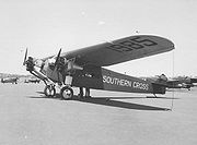 Brisbane Brisbane is the capital and most populous city in the Australian state of Queensland and the third most populous city in Australia. Brisbane's metropolitan area has a population of over 2 million, and the South East Queensland urban conurbation, centred around Brisbane, encompasses a population of... QLD, via Honolulu, Suva Suva Suva features a tropical rainforest climate under the Koppen climate classification. The city sees a copious amount of precipitation during the course of the year. Suva averages 3,000 mm of precipitation annually with its driest month, July averaging 125 mm of rain per year. In fact,... and Ballina Ballina, New South Wales Ballina is a town on the Northern Rivers of New South Wales, Australia, and the seat of the Ballina Shire Local Government Area. It had a population of 16,477 in the 2006 Census.-Location:... . Charles Kingsford Smith and Charles Ulm Charles Ulm Charles Thomas Philippe Ulm AFC was a pioneer Australian aviator.-World War I:Ulm joined the AIF in September 1914, lying about his name and age to get in. He fought and was wounded at Gallipoli in 1915, and on the Western Front in 1918.Charles Ulm was married twice. In 1919 he married Isabel... covered the 7200 miles (11,587.2 km) in 83 hours 50 minutes flying time from 31 May - 09 Jun 1928. |
Details Charles Kingsford Smith Sir Charles Edward Kingsford Smith MC, AFC , often called by his nickname Smithy, was an early Australian aviator. In 1928, he earned global fame when he made the first trans-Pacific flight from the United States to Australia... |
| 1954 AD |  |
Details |
| 1968 AD |  |
Details |
| 1973 AD |  The Las Balsas Las Balsas The 1973 Las Balsas expedition was the first multiple-raft crossing of the Pacific Ocean in recent history. It is the longest-known raft voyage in history.... rafts were towed into Ballina Ballina, New South Wales Ballina is a town on the Northern Rivers of New South Wales, Australia, and the seat of the Ballina Shire Local Government Area. It had a population of 16,477 in the 2006 Census.-Location:... by fishing trawlers after their journey from Ecuador Ecuador Ecuador , officially the Republic of Ecuador is a representative democratic republic in South America, bordered by Colombia on the north, Peru on the east and south, and by the Pacific Ocean to the west. It is one of only two countries in South America, along with Chile, that do not have a border... . They originally had planned to arrive in Mooloolaba in Queensland, but currents had forced them off their destination. Their journey was almost twice as long as the Kon-Tiki Kon-Tiki Kon-Tiki was the raft used by Norwegian explorer and writer Thor Heyerdahl in his 1947 expedition across the Pacific Ocean from South America to the Polynesian islands. It was named after the Inca sun god, Viracocha, for whom "Kon-Tiki" was said to be an old name... expeditions of 1947 and proved that people could have traveled across the Pacific in ancient times. |
Details Las Balsas The 1973 Las Balsas expedition was the first multiple-raft crossing of the Pacific Ocean in recent history. It is the longest-known raft voyage in history.... |
| 1976 AD | The Aboriginal culture in the Bundjalung Nation is evident in many aspects, including many bora rings. Casino was an important aboriginal meeting place. A bora ring more than twice the diameter of the average ring was found just north of the town. However, the site was destroyed for land fill in 1976. |
Details Bora (Australian) A Bora is the name given both to an initiation ceremony of Indigenous Australians, and to the site on which the initiation is performed. At such a site, young boys are transformed into men. The initiation ceremony differs from culture to culture, but often involves circumcision and scarification,... |
| 1983 AD | The NSW Land Rights Act 1983 was another important milestone. The dispossession of Aboriginal people from their land is acknowledged in the Act’s preamble, which states; 1. Land in the State of New South Wales was traditionally owned and occupied by Aborigines. 2. Land is of spiritual, social, cultural and economic importance to Aborigines; 3. It is fitting to acknowledge the importance which land has for Aborigines and the need for Aborigines of land. 4. It is accepted that as a result of past government decisions the amount of land set aside for Aborigines has been progressively reduced without compensation. |
Details |
| 1985 AD | A 16 hectare section of the southern part of Goanna Headland at Evans Head became the first aboriginal land grant Land grant A land grant is a gift of real estate – land or its privileges – made by a government or other authority as a reward for services to an individual, especially in return for military service... in New South Wales. |
Details Land grant A land grant is a gift of real estate – land or its privileges – made by a government or other authority as a reward for services to an individual, especially in return for military service... |
See also
- Australian frontier warsAustralian frontier warsThe Australian frontier wars were a series of conflicts fought between Indigenous Australians and European settlers. The first fighting took place in May 1788 and the last clashes occurred in the early 1930s. Indigenous fatalities from the fighting have been estimated as at least 20,000 and...
| Australian megafaunaAustralian megafaunaAustralian megafauna are a number of large animal species in Australia, often defined as species with body mass estimates of greater than 30 kilograms, or equal to or greater than 30% greater body mass than their closest living relatives...
| Bandjalang languageBandjalang languageBundjalung is an Australian Indigenous language of New South Wales.Bundjalung consists of a number of dialects, including Yugumbir, Nganduwal, Minjangbal, Njangbal, Biriin, Baryulgil, Waalubal, Dinggabal, Wiyabal, Gidabal, Galibal, and Wudjeebal.-Vowels:...
| Bundjalung peopleBundjalung peopleThe Bundjalung people are those Australian Aborigines who are the original custodians of northern coastal areas of New South Wales , 554 km northeast of Sydney: an area that includes the Bundjalung National Park and Mount Warning Bundjalung people...
| Bundjalung NationBundjalung Nation- Bundjalung language :Bundjalung belongs to the Pama–Nyungan family of Australian Aboriginal languages. ‘Bundjalung’ has been used as a general term for the whole language and also as a term to refer to certain individual dialects...
| Commercialization of traditional medicines | DirawongDirawongIn the mythology of Bundjalung Nation , the Dirawong is the Creator Being that taught the people the Aboriginal astronomy, body designs, bullroarers, bush cosmetics, bush foods, bush medicines, cave paintings and designs cut into trees, ceremonial headgear, ceremonial poles, cultural...
| History warsHistory warsThe history wars in Australia are an ongoing public debate over the interpretation of the history of the British colonisation of Australia and development of contemporary Australian society...
| List of legendary creatures | List of massacres of Indigenous Australians | List of Australian place names of Aboriginal origin