
Mount Warning
Encyclopedia
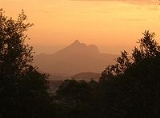
Mount Warning is a mountain
14 kilometres (9 mi) west-south-west of Murwillumbah
, near the border with Queensland
in the Northern Rivers region of New South Wales
, Australia
. Due to Mount Warning's proximity to Cape Byron
, the Australian continent's easternmost point, it is the first place on mainland Australia to receive the sun's rays each day.
It was on 16 May 1770 that Lieutenant James Cook
, seeing the mountain from the sea, named it Mount Warning.
of an ancient shield volcano
, the Tweed Volcano
, which would have been about 1900 m (6,233.6 ft) above sea level or just under twice the height of the current mountain. This volcano erupted around 23 million years ago.
As the mountain's central vent cooled it shrank, forming a depression at the top that has greatly eroded.
Today the vast areas that were part of the volcano include many mountains and ranges at some distance from Mount Warning, and include the Border Ranges
, Tamborine Mountain, the McPherson Range
and both the Lamington Plateau and Springbrook Plateaus. The erosion caldera
formed since this eruption is easily visible around the summit and forms the rim of the Tweed Valley.
During the last stages of eruption, different and more resistant forms of lava
that were cooler than those flows that created the shield volcano remained to form the current peak. The whole central Mount Warning massif
was also pushed up by forces that remained active after lava eruptions had stopped.
advertise this request and do not encourage climbers, but it is not expressly forbidden by park regulations.
was the first European to record seeing “… a remarkable sharp peaked Mountain lying inland…” from a point of land he named Cape Byron. Just five hours later while sailing North, Cook was forced to change course to the East after encountering the dangerous reefs that run 3 miles to the East from Fingal Head, now named Danger Reefs (Inner, South, and Outer reefs).
Next morning Cook recorded:
, and access is regulated by the New South Wales National Parks and Wildlife Service
. Mount Warning is part of the United Nations World Heritage
listed Gondwana Rainforests of Australia.
An ascent of the mountain is discouraged out of respect for local Aboriginal
lore, but if undertaken, takes approximately 1½ to 3½ hours (one way) and requires a good level of fitness. There are also viewing platforms at the summit. The total journey is 8.8 km.
Mountain
Image:Himalaya_annotated.jpg|thumb|right|The Himalayan mountain range with Mount Everestrect 58 14 160 49 Chomo Lonzorect 200 28 335 52 Makalurect 378 24 566 45 Mount Everestrect 188 581 920 656 Tibetan Plateaurect 250 406 340 427 Rong River...
14 kilometres (9 mi) west-south-west of Murwillumbah
Murwillumbah, New South Wales
Murwillumbah is a town of approximately 7,500 people in far north-eastern New South Wales, Australia in the Tweed Shire. It lies on the Tweed River, 848 km north-east of Sydney, 13 km south of the Queensland border and 132 km south of Brisbane. At the 2006 census, Murwillumbah had a...
, near the border with Queensland
Queensland
Queensland is a state of Australia, occupying the north-eastern section of the mainland continent. It is bordered by the Northern Territory, South Australia and New South Wales to the west, south-west and south respectively. To the east, Queensland is bordered by the Coral Sea and Pacific Ocean...
in the Northern Rivers region of New South Wales
New South Wales
New South Wales is a state of :Australia, located in the east of the country. It is bordered by Queensland, Victoria and South Australia to the north, south and west respectively. To the east, the state is bordered by the Tasman Sea, which forms part of the Pacific Ocean. New South Wales...
, Australia
Australia
Australia , officially the Commonwealth of Australia, is a country in the Southern Hemisphere comprising the mainland of the Australian continent, the island of Tasmania, and numerous smaller islands in the Indian and Pacific Oceans. It is the world's sixth-largest country by total area...
. Due to Mount Warning's proximity to Cape Byron
Cape Byron
Cape Byron is the easternmost point of the mainland of Australia. It is located about northeast of the town of Byron Bay and projects into the Pacific Ocean...
, the Australian continent's easternmost point, it is the first place on mainland Australia to receive the sun's rays each day.
It was on 16 May 1770 that Lieutenant James Cook
James Cook
Captain James Cook, FRS, RN was a British explorer, navigator and cartographer who ultimately rose to the rank of captain in the Royal Navy...
, seeing the mountain from the sea, named it Mount Warning.
Shield volcano
Mount Warning is the central volcanic remnantVolcanic plug
A volcanic plug, also called a volcanic neck or lava neck, is a volcanic landform created when magma hardens within a vent on an active volcano. When forming, a plug can cause an extreme build-up of pressure if volatile-charged magma is trapped beneath it, and this can sometimes lead to an...
of an ancient shield volcano
Shield volcano
A shield volcano is a type of volcano usually built almost entirely of fluid lava flows. They are named for their large size and low profile, resembling a warrior's shield. This is caused by the highly fluid lava they erupt, which travels farther than lava erupted from more explosive volcanoes...
, the Tweed Volcano
Tweed Volcano
Tweed Volcano was an early Miocene shield volcano in northeastern New South Wales, Australia. In the course of about three million years, Tweed Volcano was formed over the East Australia hotspot when this part of the continent passed over it around 23 million years ago...
, which would have been about 1900 m (6,233.6 ft) above sea level or just under twice the height of the current mountain. This volcano erupted around 23 million years ago.
As the mountain's central vent cooled it shrank, forming a depression at the top that has greatly eroded.
Today the vast areas that were part of the volcano include many mountains and ranges at some distance from Mount Warning, and include the Border Ranges
Border Ranges
Border Ranges can refer to:* Border Ranges National Park, a National Park north of Sydney, Australia* Border Ranges , a mountain range of the Rocky Mountains, on the border between Canada and the United States...
, Tamborine Mountain, the McPherson Range
McPherson Range
The McPherson Range is an extensive mountain range, a spur of the Great Dividing Range, heading in an easterly direction from near Wallangarra to the Pacific Ocean coastline. It forms part of the Scenic Rim on the border between the states of New South Wales and Queensland. Further west of the...
and both the Lamington Plateau and Springbrook Plateaus. The erosion caldera
Caldera
A caldera is a cauldron-like volcanic feature usually formed by the collapse of land following a volcanic eruption, such as the one at Yellowstone National Park in the US. They are sometimes confused with volcanic craters...
formed since this eruption is easily visible around the summit and forms the rim of the Tweed Valley.
During the last stages of eruption, different and more resistant forms of lava
Lava
Lava refers both to molten rock expelled by a volcano during an eruption and the resulting rock after solidification and cooling. This molten rock is formed in the interior of some planets, including Earth, and some of their satellites. When first erupted from a volcanic vent, lava is a liquid at...
that were cooler than those flows that created the shield volcano remained to form the current peak. The whole central Mount Warning massif
Massif
In geology, a massif is a section of a planet's crust that is demarcated by faults or flexures. In the movement of the crust, a massif tends to retain its internal structure while being displaced as a whole...
was also pushed up by forces that remained active after lava eruptions had stopped.
Aboriginal significance
The mountain remains a place of cultural and traditional significance to the Bundjalung people and is the site of particular ceremonies and initiation rites. The Bundjalung observe cultural and traditional restrictions forbidding the uninitiated from climbing the mountain, and, as such, generally ask that others also do not attempt to climb the mountain. The government National Parks and Wildlife ServiceNational Parks and Wildlife Service (New South Wales)
The National Parks and Wildlife Service is part of the Office of Environment and Heritage - the main government conservation agency in New South Wales, Australia....
advertise this request and do not encourage climbers, but it is not expressly forbidden by park regulations.
Origin of Mount Warning name
On 16 May 1770, Lieutenant James CookJames Cook
Captain James Cook, FRS, RN was a British explorer, navigator and cartographer who ultimately rose to the rank of captain in the Royal Navy...
was the first European to record seeing “… a remarkable sharp peaked Mountain lying inland…” from a point of land he named Cape Byron. Just five hours later while sailing North, Cook was forced to change course to the East after encountering the dangerous reefs that run 3 miles to the East from Fingal Head, now named Danger Reefs (Inner, South, and Outer reefs).
Next morning Cook recorded:
“…We now saw the breakers [reefs] again within us which we past at the distance of 1 League, they lay in the Lat de of 38°..8' [later changed to 28°..8'] & stretch off East two Leagues from a point under which is a small Island. There situation may always be found by the peaked mountain before mentioned which bears SWBW from them this and on this account I have named Mount Warning it lies 7 or 8 Leagues inland in the latitude of 28°..22" S° the land is high and hilly about it but it is conspicuous enough to be distinguished from everything else.
The point off which these shoals lay I have named Point Danger to the northward of it the land which is low trends NWBN but we soon found that it did not keep that direction long before it turnd again to the northward.”
Protected area
The mountain is now protected by the surrounding Mount Warning National ParkMount Warning National Park
Mount Warning National Park is a park in northern New South Wales, Australia, 642 km north of Sydney near the border with the state of Queensland. It surrounds Mount Warning, part of a remnant caldera of a much larger extinct volcano . The park is administered by the NSW National Parks and...
, and access is regulated by the New South Wales National Parks and Wildlife Service
National Parks and Wildlife Service (New South Wales)
The National Parks and Wildlife Service is part of the Office of Environment and Heritage - the main government conservation agency in New South Wales, Australia....
. Mount Warning is part of the United Nations World Heritage
World Heritage Site
A UNESCO World Heritage Site is a place that is listed by the UNESCO as of special cultural or physical significance...
listed Gondwana Rainforests of Australia.
An ascent of the mountain is discouraged out of respect for local Aboriginal
Australian Aborigines
Australian Aborigines , also called Aboriginal Australians, from the latin ab originem , are people who are indigenous to most of the Australian continentthat is, to mainland Australia and the island of Tasmania...
lore, but if undertaken, takes approximately 1½ to 3½ hours (one way) and requires a good level of fitness. There are also viewing platforms at the summit. The total journey is 8.8 km.
See also
- Bundjalung National ParkBundjalung National ParkBundjalung National Park is on the north coast of New South Wales, Australia, 554 km north-east of Sydney. It protects an area of coastal plain, heathland and solitary beaches between the towns of Iluka and Evans Head....
- List of volcanoes in Australia