

Boston transportation
Encyclopedia
Massachusetts Port Authority
Massachusetts Port Authority, or Massport, is a port district in the Commonwealth of Massachusetts. It operates seaports and airports in eastern and central Massachusetts, mainly the Port of Boston. Its headquarters is located in the Logan Office Center, adjacent to Logan Airport in East Boston,...
(Massport) operates the Port of Boston
Port of Boston
The Port of Boston, , is a major seaport located in Boston Harbor and adjacent to the City of Boston...
, which includes a container shipping facility in South Boston, and Logan International Airport
Logan International Airport
General Edward Lawrence Logan International Airport is located in the East Boston neighborhood of Boston, Massachusetts . It covers , has six runways, and employs an estimated 16,000 people. It is the 19th busiest airport in the United States.Boston serves as a focus city for JetBlue Airways...
in East Boston. The Massachusetts Bay Transportation Authority
Massachusetts Bay Transportation Authority
The Massachusetts Bay Transportation Authority, often referred to as the MBTA or simply The T, is the public operator of most bus, subway, commuter rail and ferry systems in the greater Boston, Massachusetts, area. Officially a "body politic and corporate, and a political subdivision" of the...
(MBTA) operates bus, subway, short distance rail, and water ferry passenger services throughout the city and region. Amtrak
Amtrak
The National Railroad Passenger Corporation, doing business as Amtrak , is a government-owned corporation that was organized on May 1, 1971, to provide intercity passenger train service in the United States. "Amtrak" is a portmanteau of the words "America" and "track". It is headquartered at Union...
operates passenger rail service to and from major north-eastern cities. A major bus terminal at South Station
South Station
South Station, New England's second-largest transportation center , located at the intersection of Atlantic Avenue and Summer Street in Dewey Square, Boston, Massachusetts, is the largest train station and intercity bus terminal in Greater Boston, a prominent train station in the northeastern...
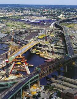
is served by varied intercity bus companies. The city is bisected by major highways, I-90 and I-93, the intersection of which has recently undergone a major renovation, nicknamed the Big Dig.
Road infrastructure
Boston
Boston is the capital of and largest city in Massachusetts, and is one of the oldest cities in the United States. The largest city in New England, Boston is regarded as the unofficial "Capital of New England" for its economic and cultural impact on the entire New England region. The city proper had...
, Massachusetts
Massachusetts
The Commonwealth of Massachusetts is a state in the New England region of the northeastern United States of America. It is bordered by Rhode Island and Connecticut to the south, New York to the west, and Vermont and New Hampshire to the north; at its east lies the Atlantic Ocean. As of the 2010...
may seem as though they were not planned—a common fiction is that they evolved from old cowpaths—but in the 17th century they avoided swamps and marshes and followed shorelines before the original peninsula comprising the city was expanded with landfill in the 19th century. Except for the Back Bay and part of South Boston, Boston has no street grid, which is confusing for nonresident drivers. Roads change names and lose and add lanes seemingly at random, and many drivers are flummoxed by rotaries.
Expressways and major arterial roads in and around Boston are laid out with two circumferential expressways: Interstate 495 and Route 128. The circumferential routes are bisected by several radial highways that were planned to start in downtown Boston and proceed outward from the city. In reality, the Central Artery
Central Artery
The John F. Fitzgerald Expressway, known locally as the Central Artery, is a section of freeway in downtown Boston, Massachusetts, designated as Interstate 93, U.S. Route 1 and Route 3. It was initially constructed in the 1950s as a partly elevated and partly tunneled divided highway...
was the only one of these radial expressways that was fully completed. The freeway revolt prompted the governor of Massachusetts to halt construction on all remaining expressways within the Route 128 beltway in the early 1970s in lieu of light rail/subway lines to serve areas through which the radial expressways were planned.
By the early 1990s traffic on the elevated artery was 190,000 vehicles per day, with an accident rate four times the national average for urban interstates. Traffic was bumper-to-bumper for six to eight hours per day, with projections of traffic jams doubling by 2010. Plus, the elevated structure itself was decaying.
For most of the 1990s and early 2000s, driving in Boston was disrupted by the Big Dig, the most expensive (roughly $14 billion) road project in the history of the United States
United States
The United States of America is a federal constitutional republic comprising fifty states and a federal district...
.
Walking and bicycling
.png)
Prevention (magazine)
Prevention is an American healthy lifestyle magazine, started in 1950, and published by Rodale Press in Emmaus, Pennsylvania, in the United States. The range of subjects includes food, nutrition, workouts, beauty, and cooking. It was founded by J. I. Rodale...
magazine report in 2003, the city has the highest percentage of on-foot commuters of any city in the United States. In 2000, 13.36% of Boston commuters walked to work according to the US Census
United States Census
The United States Census is a decennial census mandated by the United States Constitution. The population is enumerated every 10 years and the results are used to allocate Congressional seats , electoral votes, and government program funding. The United States Census Bureau The United States Census...
. This was the highest of any major US city, but bested by college towns such as nearby Cambridge
Cambridge, Massachusetts
Cambridge is a city in Middlesex County, Massachusetts, United States, in the Greater Boston area. It was named in honor of the University of Cambridge in England, an important center of the Puritan theology embraced by the town's founders. Cambridge is home to two of the world's most prominent...
. Most of the area's cities and towns have standing committees devoted to improvements to the bicycle and pedestrian environment.
Cycling is popular in Boston, for both recreation and commuting. Some bicycle paths are marked on some roadways, and very few separated paths are available to cyclists. The Minuteman Bikeway (which runs though several suburbs of Boston) and Charles River
Charles River
The Charles River is an long river that flows in an overall northeasterly direction in eastern Massachusetts, USA. From its source in Hopkinton, the river travels through 22 cities and towns until reaching the Atlantic Ocean at Boston...
bike paths are popular with recreational cyclists and tourists. The Southwest Corridor
Southwest Corridor
The Southwest Corridor or Southwest Expressway was a project designed to bring an eight-lane highway into the City of Boston from a direction southwesterly of downtown. It was supposed to connect with Interstate 95 at Route 128...
also provides cycling infrastructure. Many MBTA riders use a bicycle to get to the station.
However Bicycling magazine, in its March 2006 issue, named the city as one of its three worst cities in the United States for cycling. The distinction was earned for roads that are in terrible shape, few bike lanes that are disconnected, and a city government that makes pro-bike gestures, then rescinds them, such as hiring a bike coordinator, then eliminating the position after only two years. Neighboring Cambridge
Cambridge, Massachusetts
Cambridge is a city in Middlesex County, Massachusetts, United States, in the Greater Boston area. It was named in honor of the University of Cambridge in England, an important center of the Puritan theology embraced by the town's founders. Cambridge is home to two of the world's most prominent...
earned an honorable mention as one of the best cities for cycling with a population of 75,000-200,000. Boston has an active Critical Mass
Critical Mass
Critical Mass is a cycling event typically held on the last Friday of every month in over 300 cities around the world. The ride was originally founded in 1992 in San Francisco. The purpose of Critical Mass is not usually formalized beyond the direct action of meeting at a set location and time and...
ride and MassBike is a bike advocacy group active in supporting cyclists in the area.
Buses
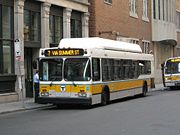
MBTA Bus
The Massachusetts Bay Transportation Authority operates a large number of bus lines in the greater Boston area. Some routes are for transport within the city; others bring passengers from surrounding areas to stops on the rail lines of the MBTA.The MBTA also operates bus rapid transit service; see...
operates 162 bus
Bus
A bus is a road vehicle designed to carry passengers. Buses can have a capacity as high as 300 passengers. The most common type of bus is the single-decker bus, with larger loads carried by double-decker buses and articulated buses, and smaller loads carried by midibuses and minibuses; coaches are...
routes within the Greater Boston area with a
combined ridership of approximately 375,000 one-way trips per day, making it the sixth-busiest local bus agency in the country. Included within the MBTA system are four of the few remaining trolleybus
Trolleybus
A trolleybus is an electric bus that draws its electricity from overhead wires using spring-loaded trolley poles. Two wires and poles are required to complete the electrical circuit...
lines in the U.S. (71, 72, 73 and 77A), although these principally operate in the adjoining city of Cambridge
Cambridge, Massachusetts
Cambridge is a city in Middlesex County, Massachusetts, United States, in the Greater Boston area. It was named in honor of the University of Cambridge in England, an important center of the Puritan theology embraced by the town's founders. Cambridge is home to two of the world's most prominent...
. The basic bus fare is $1.25; monthly commuter passes are available, as are transfers between some bus lines and the subway.
In an effort to provide service intermediate in speed and capacity between subways and buses, the MBTA has begun projects using the Bus Rapid Transit
Bus rapid transit
Bus rapid transit is a term applied to a variety of public transportation systems using buses to provide faster, more efficient service than an ordinary bus line. Often this is achieved by making improvements to existing infrastructure, vehicles and scheduling...
, or BRT, system. The MBTA has one BRT line, the Silver Line
Silver Line (MBTA)
The Silver Line is the only bus rapid transit line currently operated by the Massachusetts Bay Transportation Authority . It operates in two sections; the first runs from Dudley Square in Roxbury to downtown Boston, Massachusetts and South Station, mostly via Washington Street, with buses...
, although this operates in two discontinuous sections. The Silver Line operates in part in a dedicated trolleybus tunnel, in part in on-street bus lane
Bus lane
A bus lane or bus only lane is a lane restricted to buses, and generally used to speed up public transport that would be otherwise held up by traffic congestion...
s, and in part in general street traffic. Service through the trolleybus tunnel is by dual-mode bus
Dual-mode bus
A dual-mode bus is a bus that can run independently on power from two different sources, typically electricity from overhead lines or batteries, alternated with conventional fossil fuel ....
es, which operate electrically in the tunnel and on a short section on the surface and use diesel power for the rest of the route.
In addition to local bus service and BRT, South Station
South Station
South Station, New England's second-largest transportation center , located at the intersection of Atlantic Avenue and Summer Street in Dewey Square, Boston, Massachusetts, is the largest train station and intercity bus terminal in Greater Boston, a prominent train station in the northeastern...
is a major bus depot
Bus station
A bus station is a structure where city or intercity buses stop to pick up and drop off passengers. It is larger than a bus stop, which is usually simply a place on the roadside, where buses can stop...
for inter-city travel. Many bus lines such as Greyhound
Greyhound Lines
Greyhound Lines, Inc., based in Dallas, Texas, is an intercity common carrier of passengers by bus serving over 3,700 destinations in the United States, Canada and Mexico, operating under the well-known logo of a leaping greyhound. It was founded in Hibbing, Minnesota, USA, in 1914 and...
and Peter Pan
Peter Pan Bus Lines
Peter Pan Bus Lines is a long-distance bus carrier headquartered in Springfield, Massachusetts. It operates in the northeastern United States. Over four million passengers per year travel on Peter Pan's bus routes....
operate from the station. BoltBus
BoltBus
BoltBus is a bus line operating in the northeastern United States. It is a 50/50 venture between Greyhound Lines and Peter Pan Bus Lines providing service between New York City and other cities in the northeastern United States, utilizing the existing operating authority of Greyhound Lines...
and Megabus both provide low-cost bus service between Boston and their New York hubs.
Several companies operate tourist trolley
Tourist trolley
A tourist trolley, also called a road trolley, is a rubber-tired bus , which is made to resemble an old-style streetcar or tram....
s on hop-on/hop-off tours of Boston. Other companies operate duck tour
Duck tour
Duck tours, or DUKW tours, are tours that take place on purpose-built amphibious tour buses or military surplus DUKWs and LARC-Vs.Duck tours are primarily offered as tourist attractions in harbor, river and lake cities, such as Halifax, Albany, Austin, Baltimore, Chattanooga, Pittsburgh, Belfast,...
s that use amphibious vehicles, mostly derived from World War II
World War II
World War II, or the Second World War , was a global conflict lasting from 1939 to 1945, involving most of the world's nations—including all of the great powers—eventually forming two opposing military alliances: the Allies and the Axis...
era DUKW
DUKW
The DUKW is a six-wheel-drive amphibious truck that was designed by a partnership under military auspices of Sparkman & Stephens and General Motors Corporation during World War II for transporting goods and troops over land and water and for use approaching and crossing beaches in amphibious...
s, and encompass both the city's streets and its waterways.
Taxis
Boston has a fleet of 1,825 taxis, In 2008 the city mandated that all its taxicab fleet must be converted to hybridsHybrid taxi
Hybrid taxi or hybrid electric taxi is a taxicab service provided with a hybrid electric car , which combines a conventional internal combustion engine propulsion system with an electric propulsion system....
by 2015, however, in March 2009 a group of taxi drivers and medallion owners sued in federal court to block the requirement. In July 2009 a federal judge granted the request for a temporary injunction and ordered the city to stop enforcing the mandate.
The city launched the CleanAir Cabs program in April 2007. The program promotes replacing older fuel-inefficient cabs with hybrid and alternative fuel vehicles as the existing fleet ages out. The main benefit of the CleanAir Cabs program for cab drivers is the operating savings, as hybrid taxi cabs can get up to three times as many miles per gallon of fuel as the old Crown Victoria cabs. In addition, hybrid taxi drivers get two "front of the line" passes per shift at Logan Airport, allowing them to make two extra trips daily. Hybrid taxi owners who lease vehicles to drivers are allowed to charge drivers more per shift to lease a taxi, enabling medallion owners to earn more than annually. As of March 2009 about 10% of the taxicab fleet were already hybrids as owner voluntarily began introducing HEVs since 2002, mainly Toyota Camry Hybrids plus those introduced by the incentives of the CleanAir Cabs program.
Parking
Automobile parking was not a particular concern of Boston's first settlers. The city that sprung up accommodates cars only awkwardly; parking comes at a premium throughout the city. Off-street parking spaces have sold for more than $160,000 in Beacon Hill. Understandably, on-street parking is the norm in many sections, and the city created a resident permit parking program to reserve street space for permanent residents. The cost to obtain a permit is extremely low, however, and the program is overused; permitted spaces remain scarce. Meters city-wide are priced at $1 per hour, and thus metered spaces also often are difficult to find.The number of public parking spaces downtown has been capped since the mid-1970s. The number of parking spaces in East and South Boston, and the hours that they may be used, also is restricted by state regulation. This is part of the state Department of Environmental Protection's plan, approved by the United States Environmental Protection Agency
United States Environmental Protection Agency
The U.S. Environmental Protection Agency is an agency of the federal government of the United States charged with protecting human health and the environment, by writing and enforcing regulations based on laws passed by Congress...
to address the non-compliance of the region with the mandatory National Ambient Air Quality Standards
National Ambient Air Quality Standards
The National Ambient Air Quality Standards are standards established by the United States Environmental Protection Agency under authority of the Clean Air Act that apply for outdoor air throughout the country...
for ozone
Ozone
Ozone , or trioxygen, is a triatomic molecule, consisting of three oxygen atoms. It is an allotrope of oxygen that is much less stable than the diatomic allotrope...
.
The MBTA operates several large park and ride
Park and ride
Park and ride facilities are car parks with connections to public transport that allow commuters and other people wishing to travel into city centres to leave their vehicles and transfer to a bus, rail system , or carpool for the rest of their trip...
facilities on its subway and commuter rail lines, close to major highways, providing access to downtown. While most of these tend to fill up with commuters on weekday mornings, they provide a good place for visitors to leave their cars and see the city without parking hassles on evenings and weekends.
Rail transportation
Boston has two discrete rail networks. One of these is normally called the subway, although it also runs at and above surface level, and includes elements of light railLight rail
Light rail or light rail transit is a form of urban rail public transportation that generally has a lower capacity and lower speed than heavy rail and metro systems, but higher capacity and higher speed than traditional street-running tram systems...
and streetcar operation as well as traditional subway
Rapid transit
A rapid transit, underground, subway, elevated railway, metro or metropolitan railway system is an electric passenger railway in an urban area with a high capacity and frequency, and grade separation from other traffic. Rapid transit systems are typically located either in underground tunnels or on...
technology. The second network forms the Boston area portion of the national common user railroad
Rail transport in the United States
Presently, most rail transport in the United States is based on freight train shipments. The U.S. rail industry has experienced repeated convulsions due to changing U.S. economic needs and the rise of automobile, bus, and air transport....
network, and provides commuter rail, intercity passenger rail and freight rail services.
Although the two networks are essentially unconnected, they do in some places run alongside each other in the same reservation. Interchange stations allow interchange of passengers, but not trains, between subway and commuter rail services. Parts of the subway network also use former common user rail rights of way.
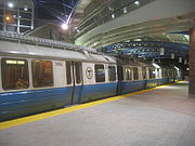
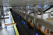
Subway network
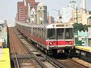

In the early 1960s, the then new MBTA hired Cambridge Seven Associates
Cambridge Seven Associates
Cambridge Seven Associates, Inc. is an American architecture firm founded in 1962 and based in Cambridge, Massachusetts. The firm was founded upon the idea that the collaborative efforts of a varied group of designers and architects would be far more effective than those of any one individual...
to help develop a new identity. Cambridge Seven came up with a circled T to represent such concepts as "transit", "transportation" and "tunnel." Today, Bostonians call their rapid transit network "the T" and its subway is the fourth busiest in the country, with daily ridership of 549,000 trips excluding the Silver Line bus, which compares with the Washington Metro
Washington Metro
The Washington Metro, commonly called Metro, and unofficially Metrorail, is the rapid transit system in Washington, D.C., United States, and its surrounding suburbs. It is administered by the Washington Metropolitan Area Transit Authority , which also operates Metrobus service under the Metro name...
's 910,100, the Chicago L
Chicago 'L'
The L is the rapid transit system serving the city of Chicago and some of its surrounding suburbs. It is operated by the Chicago Transit Authority...
's 596,300, and Los Angeles's 126,900, though is dwarfed like the rest by New York City's 6.0 million average daily weekday trips taken.
The basic one-way fare is $1.70 (or $2.00 if paid cash). Monthly commuter passes and day and week visitor's passes are available. There are four subway
Rapid transit
A rapid transit, underground, subway, elevated railway, metro or metropolitan railway system is an electric passenger railway in an urban area with a high capacity and frequency, and grade separation from other traffic. Rapid transit systems are typically located either in underground tunnels or on...
lines in the metropolitan Boston area: the Red Line
Red Line (MBTA)
The Red Line is a rapid transit line operated by the MBTA running roughly north-south through Boston, Massachusetts into neighboring communities. The line begins west of Boston, in Cambridge, Massachusetts at Alewife station, near the intersection of Alewife Brook Parkway and Route 2...
, Green Line
Green Line (MBTA)
The Green Line is a streetcar system run by the Massachusetts Bay Transportation Authority in the Boston, Massachusetts area of the United States. It is the oldest line of Boston's subway, which is known locally as the 'T'. The Green Line runs underground downtown and on the surface in outlying...
, Orange Line
Orange Line (MBTA)
The Orange Line is one of the four subway lines of the Massachusetts Bay Transportation Authority. It extends from Forest Hills in Jamaica Plain, Boston in the south to Oak Grove in Malden, Massachusetts in the north. It meets the Red Line at Downtown Crossing, the Blue Line at State, and the Green...
, and Blue Line
Blue Line (MBTA)
The Blue Line is one of four subway lines of the Massachusetts Bay Transportation Authority serving Downtown, East Boston and the North Shore. It runs from northeast to southwest, extending from Wonderland station in Revere, Massachusetts to Bowdoin station near Beacon Hill in Boston...
. The colors of each line have a meaning: the Blue Line runs along the ocean; the Red Line used to terminate at Harvard University
Harvard University
Harvard University is a private Ivy League university located in Cambridge, Massachusetts, United States, established in 1636 by the Massachusetts legislature. Harvard is the oldest institution of higher learning in the United States and the first corporation chartered in the country...
(whose school color is crimson
Crimson
Crimson is a strong, bright, deep red color. It is originally the color of the dye produced from a scale insect, Kermes vermilio, but the name is now also used as a generic term for those slightly bluish-red colors that are between red and rose; besides crimson itself, these colors include...
); the Orange Line used to run along Washington Street, which was once called Orange Street; and The Green Line runs into the leafy suburbs of Brookline
Brookline, Massachusetts
Brookline is a town in Norfolk County, Massachusetts, United States, which borders on the cities of Boston and Newton. As of the 2010 census, the population of the town was 58,732.-Etymology:...
and Newton
Newton, Massachusetts
Newton is a city in Middlesex County, Massachusetts, United States bordered to the east by Boston. According to the 2010 U.S. Census, the population of Newton was 85,146, making it the eleventh largest city in the state.-Villages:...
.
The Green Line is actually four different lines; it starts as one and about halfway through the system it splits into four different branches, the B (Boston College), C (Cleveland Circle), D (Riverside) and E (Heath Street) trains. Because the split is only present on the outbound end of the line one may take any train inbound, but when going outbound one must be careful of which train one gets on or else one will end up in a very different place. The Red Line splits as well, with southbound trains going either to Braintree or Ashmont.
Though most of Boston's rapid transit
Rapid transit
A rapid transit, underground, subway, elevated railway, metro or metropolitan railway system is an electric passenger railway in an urban area with a high capacity and frequency, and grade separation from other traffic. Rapid transit systems are typically located either in underground tunnels or on...
network is powered via third rail
Third rail
A third rail is a method of providing electric power to a railway train, through a semi-continuous rigid conductor placed alongside or between the rails of a railway track. It is used typically in a mass transit or rapid transit system, which has alignments in its own corridors, fully or almost...
, significant portions of the Blue Line, as well as all of the Green Line and the Mattapan High Speed Line
Ashmont-Mattapan High Speed Line
The Ashmont–Mattapan High Speed Line or also known as the "M-Line" in Boston and Milton, Massachusetts is considered to be part of the MBTA's Red Line, even though it uses different equipment and passengers have to change at Ashmont. The only MBTA line to run through a cemetery, the line opened on...
are powered by overhead lines
Overhead lines
Overhead lines or overhead wires are used to transmit electrical energy to trams, trolleybuses or trains at a distance from the energy supply point...
. The name "subway" is something of a misnomer, as with other systems, large segments run above ground when far from the city's downtown. Additionally, the Green Line and Mattapan High Speed Lines are technically light-rail services, using tram
Tram
A tram is a passenger rail vehicle which runs on tracks along public urban streets and also sometimes on separate rights of way. It may also run between cities and/or towns , and/or partially grade separated even in the cities...
s rather than the typical multiple unit
Multiple unit
The term multiple unit or MU is used to describe a self-propelled carriages capable of coupling with other units of the same or similar type and still being controlled from one driving cab. The term is commonly used to denote passenger trainsets consisting of more than one carriage...
trains. The Mattapan line uses refurbished pre-war "PCC
PCC streetcar
The PCC streetcar design was first built in the United States in the 1930s. The design proved successful in its native country, and after World War II was licensed for use elsewhere in the world...
" trolleys; the Green Line relies on more modern LRV
LRV
LRV might refer to:*L.R.V. or Luis R. Villafuerte, Jr.*L.R.V. video*Lenticular Reentry Vehicle*Lietuvos Respublikos Vyriausybė*Light rail vehicle*Lunar Roving Vehicle*Light Reflectance Value...
cars from Japan and Italy.
Like the New York City subway
New York City Subway
The New York City Subway is a rapid transit system owned by the City of New York and leased to the New York City Transit Authority, a subsidiary agency of the Metropolitan Transportation Authority and also known as MTA New York City Transit...
, Boston's subway system does keep to an exact fixed schedule (unlike the Tokyo subway
Tokyo Subway
The is an integral part of the world's most extensive rapid transit system in a single metropolitan area, Greater Tokyo. While the subway system itself is largely within the city center, the lines extend far out via extensive through services onto suburban railway lines.- Networks :As of June...
) and it has no mechanism in place to inform customers of current train locations or estimated times until arrivals (unlike the Washington Metro
Washington Metro
The Washington Metro, commonly called Metro, and unofficially Metrorail, is the rapid transit system in Washington, D.C., United States, and its surrounding suburbs. It is administered by the Washington Metropolitan Area Transit Authority , which also operates Metrobus service under the Metro name...
).
Elevated sections
Despite the first section being built underground, many later parts were built as elevated railwayElevated railway
An elevated railway is a form of rapid transit railway with the tracks built above street level on some form of viaduct or other steel or concrete structure. The railway concerned may be constructed according to the standard gauge, narrow gauge, light rail, monorail or suspension railway system...
s. The only remaining elevated portions are the Green Line
Green Line (MBTA)
The Green Line is a streetcar system run by the Massachusetts Bay Transportation Authority in the Boston, Massachusetts area of the United States. It is the oldest line of Boston's subway, which is known locally as the 'T'. The Green Line runs underground downtown and on the surface in outlying...
's Lechmere Viaduct
Lechmere Viaduct
The Lechmere Viaduct is the last remaining elevated portion of the MBTA's Green Line in Boston, Massachusetts. Opened June 1, 1912, the Viaduct connects the Lechmere stop to the Science Park Station at Leverett Circle. Currently, the Green Line descends into a tunnel just east of Science Park...
, including the Science Park
Science Park (MBTA station)
Science Park, signed as Science Park/West End, is a station on the MBTA Green Line and is located at the Boston end of the Old Charles River Dam at Leverett Circle, near the intersection of Nashua Street and Charles Street . The station is located on the elevated Lechmere Viaduct, which connects...
station, and the Red Line
Red Line (MBTA)
The Red Line is a rapid transit line operated by the MBTA running roughly north-south through Boston, Massachusetts into neighboring communities. The line begins west of Boston, in Cambridge, Massachusetts at Alewife station, near the intersection of Alewife Brook Parkway and Route 2...
at Charles-MGH, between the tunnel under Beacon Hill
Beacon Hill, Boston, Massachusetts
Beacon Hill is a historic neighborhood of Boston, Massachusetts, that along with the neighboring Back Bay is home to about 26,000 people. It is a neighborhood of Federal-style rowhouses and is known for its narrow, gas-lit streets and brick sidewalks...
and the Longfellow Bridge
Longfellow Bridge
The Longfellow Bridge, also known to locals as the "Salt-and-Pepper Bridge" or the "Salt-and-Pepper-Shaker Bridge" due to the shape of its central towers, carries Route 3 and the Massachusetts Bay Transportation Authority's Red Line across the Charles River to connect Boston's Beacon Hill...
.
The Boston Elevated Railway
Boston Elevated Railway
The Boston Elevated Railway was a precursor first to the Metropolitan Transit Authority in Massachusetts, now the Massachusetts Bay Transportation Authority, operating rapid transit, streetcars and buses in the Boston, Massachusetts area. It was formerly known as the West End Street Railway.The...
was the company that owned all the elevateds and subways. The following els once existed:
- Causeway Street ElevatedCauseway Street ElevatedThe Causeway Street Elevated was a part of the MBTA's Green Line in Boston, Massachusetts that ran roughly northwards from Haymarket, then ran westwards for a short distance around the Boston Garden indoor sports venue's exterior through the Green Line's North Station stop, and resumed a...
(closed 2004), from the Haymarket Incline to the Lechmere ViaductLechmere ViaductThe Lechmere Viaduct is the last remaining elevated portion of the MBTA's Green Line in Boston, Massachusetts. Opened June 1, 1912, the Viaduct connects the Lechmere stop to the Science Park Station at Leverett Circle. Currently, the Green Line descends into a tunnel just east of Science Park... - Washington Street ElevatedWashington Street ElevatedThe Washington Street Elevated was an elevated segment of Boston's Massachusetts Bay Transportation Authority subway system, comprising the southern stretch of the Orange Line . It ran from Chinatown through the South End and Roxbury, ending in Forest Hills in Jamaica Plain...
(closed 1987), from Forest HillsForest Hills (MBTA station)Forest Hills Station is a station on the MBTA Orange Line, located in Forest Hills in the southern part of the Jamaica Plain neighborhood of Boston, Massachusetts at the intersections of Washington Street, Hyde Park Avenue, South Street, The Arborway and Morton Street.Forest Hills is the southern...
to an incline north of the Masspike - Charlestown ElevatedCharlestown ElevatedThe Charlestown Elevated was a former link of Boston's Orange Line rapid transit line that ran from a portal at North Station, near the old Boston Garden, to the city of Everett, Massachusetts...
(closed April 4, 1975), from the Haymarket Incline to EverettEverett, MassachusettsEverett is a city in Middlesex County, Massachusetts, United States, near Boston. The population was 41,667 at the 2010 census.Everett is the last city in the United States with a bicameral legislature, which is composed of a seven-member Board of Aldermen and an 18-member Common Council... - Atlantic Avenue ElevatedAtlantic Avenue ElevatedThe Atlantic Avenue Elevated was an elevated railway around the east side of downtown Boston, Massachusetts, providing a second route for the Boston Elevated Railway's Main Line around the Washington Street Tunnel...
(closed 1938), from the Washington Street El at the Castle Street Wye at Herald Street (Tower 'D') to the Charlestown El and Causeway Street El at North Station (Tower 'C')
Common user rail network
Unlike the subway, which is owned and operated by the MBTA, the common user network is owned and operated by a mixture of various public and private sector bodies. In the Boston area, trackage is owned by a mixture of the MBTA and several freight railroads. Commuter rail services are operated by the Massachusetts Bay Commuter Railroad Company (MBCR) under contract to the MBTA, intercity passenger services are operated by AmtrakAmtrak
The National Railroad Passenger Corporation, doing business as Amtrak , is a government-owned corporation that was organized on May 1, 1971, to provide intercity passenger train service in the United States. "Amtrak" is a portmanteau of the words "America" and "track". It is headquartered at Union...
, and freight services are operated by the various freight railroads. Trackage rights
Trackage rights
Trackage rights , running rights or running powers is an agreement whereby a railway company has the right to run its trains on tracks owned by another railway company....
allow trains of one operator to make use of tracks owned by another.
Commuter rail
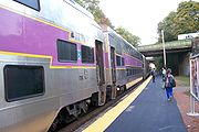
MBTA Commuter Rail
The MBTA Commuter Rail serves as the regional rail arm of the Massachusetts Bay Transportation Authority, in the United States. It is operated under contract by the Massachusetts Bay Commuter Railroad Company a joint partnership of Veolia Transportation, Bombardier Transportation and Alternate...
system, sometimes known as the Purple Line, brings people from as far away as Worcester
Worcester, Massachusetts
Worcester is a city and the county seat of Worcester County, Massachusetts, United States. Named after Worcester, England, as of the 2010 Census the city's population is 181,045, making it the second largest city in New England after Boston....
and Providence, Rhode Island
Providence, Rhode Island
Providence is the capital and most populous city of Rhode Island and was one of the first cities established in the United States. Located in Providence County, it is the third largest city in the New England region...
into Boston. There are approximately 125,000 one-way trips on the commuter rail each day, making it the fifth-busiest commuter rail system in the country, after only New York and Chicago systems.
There are two major rail terminals in Boston: North Station and South Station
South Station
South Station, New England's second-largest transportation center , located at the intersection of Atlantic Avenue and Summer Street in Dewey Square, Boston, Massachusetts, is the largest train station and intercity bus terminal in Greater Boston, a prominent train station in the northeastern...
. Commuter rail lines from the North Shore and northwestern suburbs begin and terminate at North Station; lines from the South Shore and the west start and end at South Station. There is no direct rail connection between North Station and South Station and interchange between the two stations requires the use of two different subway lines (Red/Orange or Red/Green), although passengers on commuter lines serving Back Bay Station
Back Bay (MBTA station)
Back Bay station, located at 145 Dartmouth Street, between Stuart Street and Columbus Avenue, is a train station in the Back Bay neighborhood of Boston...
can interchange directly from there to North Station using the Orange line, and passengers on the Fitchburg Line
Fitchburg Line
The Fitchburg Line is an MBTA line that runs from Boston's North Station to Fitchburg, Massachusetts. The line is along the tracks of the former Fitchburg Railroad, which was a railroad line across northern Massachusetts, United States, leading to and through the Hoosac Tunnel. It is one of the...
can interchange directly from Porter
Porter (MBTA station)
Porter is a train station in Cambridge, Massachusetts. It is located at the intersection of Massachusetts Avenue and Somerville Avenue . It also serves portions of Somerville. The station was designed by Cambridge Seven Associates and opened on December 8, 1984. At 105 feet below ground, it is the...
to South Station using the Red line. A North-South Rail Link
North-South Rail Link
The North–South Rail Link is a proposed pair of approximately 1.5 mile -long rail tunnels below downtown Boston, Massachusetts.The tunnels would serve the goals of better unification for Boston's separate northern and southern MBTA Commuter Rail terminals, and provide direct linkage between...
has been proposed to allow commuter trains to serve both North and South stations, but there are no definite plans to build this.
Intercity rail
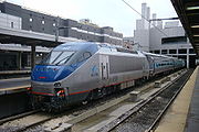
Amtrak
The National Railroad Passenger Corporation, doing business as Amtrak , is a government-owned corporation that was organized on May 1, 1971, to provide intercity passenger train service in the United States. "Amtrak" is a portmanteau of the words "America" and "track". It is headquartered at Union...
. The Acela Express
Acela Express
The Acela Express is Amtrak's high-speed rail service along the Northeast Corridor in the Northeast United States between Washington, D.C., and Boston via Baltimore, Philadelphia, and New York...
and Northeast Regional services both operate on the Northeast Corridor
Northeast Corridor
The Northeast Corridor is a fully electrified railway line owned primarily by Amtrak serving the Northeast megalopolis of the United States from Boston in the north, via New York to Washington, D.C. in the south, with branches serving other cities...
to and from New York City
New York City
New York is the most populous city in the United States and the center of the New York Metropolitan Area, one of the most populous metropolitan areas in the world. New York exerts a significant impact upon global commerce, finance, media, art, fashion, research, technology, education, and...
and Washington
Washington, D.C.
Washington, D.C., formally the District of Columbia and commonly referred to as Washington, "the District", or simply D.C., is the capital of the United States. On July 16, 1790, the United States Congress approved the creation of a permanent national capital as permitted by the U.S. Constitution....
. A branch of the Lake Shore Limited
Lake Shore Limited
The Lake Shore Limited is a daily passenger train route operated by Amtrak in the Northeastern and Midwestern United States. The train runs between Chicago and Albany, NY, where it divides into two sections that provide thru-service to New York and Boston...
service operates to and from Chicago
Chicago
Chicago is the largest city in the US state of Illinois. With nearly 2.7 million residents, it is the most populous city in the Midwestern United States and the third most populous in the US, after New York City and Los Angeles...
. The Downeaster
Downeaster
The Downeaster is a 116-mile regional passenger train service managed by the Northern New England Passenger Rail Authority and operated by Amtrak, connecting North Station in Boston, Massachusetts, to Portland, Maine...
service operates to and from Portland
Portland, Maine
Portland is the largest city in Maine and is the county seat of Cumberland County. The 2010 city population was 66,194, growing 3 percent since the census of 2000...
, Maine
Maine
Maine is a state in the New England region of the northeastern United States, bordered by the Atlantic Ocean to the east and south, New Hampshire to the west, and the Canadian provinces of Quebec to the northwest and New Brunswick to the northeast. Maine is both the northernmost and easternmost...
.
The Northeast Corridor services terminate at South Station, as does the Lake Shore Limited. The Downeaster service terminates at North Station, primarily because the Downeaster Amtrak line is intended for points north of downtown. The Northeast Corridor and Lake Shore Limited services also stop at Back Bay Station
Back Bay (MBTA station)
Back Bay station, located at 145 Dartmouth Street, between Stuart Street and Columbus Avenue, is a train station in the Back Bay neighborhood of Boston...
. The lack of a direct rail connection between North Station and South Station means that passengers transferring to and from the Downeaster are faced with a transfer between stations. Although most such transfers can be achieved using the Orange Line
Orange Line (MBTA)
The Orange Line is one of the four subway lines of the Massachusetts Bay Transportation Authority. It extends from Forest Hills in Jamaica Plain, Boston in the south to Oak Grove in Malden, Massachusetts in the north. It meets the Red Line at Downtown Crossing, the Blue Line at State, and the Green...
between Back Bay and North Station, Amtrak recommends passengers with luggage to use a taxi.
Within the Boston area, most Amtrak services operate over commuter rail track owned by the MBTA, who also own the Northeast Corridor track as far as the Rhode Island
Rhode Island
The state of Rhode Island and Providence Plantations, more commonly referred to as Rhode Island , is a state in the New England region of the United States. It is the smallest U.S. state by area...
state line.
Freight rail
CSXCSX Transportation
CSX Transportation operates a Class I railroad in the United States known as the CSX Railroad. It is the main subsidiary of the CSX Corporation. The company is headquartered in Jacksonville, Florida, and owns approximately 21,000 route miles...
is the only class I railroad
Class I railroad
A Class I railroad in the United States and Mexico, or a Class I rail carrier in Canada, is a large freight railroad company, as classified based on operating revenue.Smaller railroads are classified as Class II and Class III...
serving the Boston area, which it reaches by its Boston Subdivision
Boston Subdivision
The Boston Subdivision is a railroad line owned by CSX Transportation in the U.S. state of Massachusetts. The line runs from Boston west to near Springfield along a former New York Central Railroad line. Its east end is at Amtrak's Northeast Corridor at Back Bay Station, over which CSX has...
line to Springfield
Springfield, Massachusetts
Springfield is the most populous city in Western New England, and the seat of Hampden County, Massachusetts, United States. Springfield sits on the eastern bank of the Connecticut River near its confluence with three rivers; the western Westfield River, the eastern Chicopee River, and the eastern...
, and by trackage rights
Trackage rights
Trackage rights , running rights or running powers is an agreement whereby a railway company has the right to run its trains on tracks owned by another railway company....
over the Northeast Corridor. CSX also has trackage rights over much of the southern half of the MBTA's commuter rail network. CSX's principal rail freight facility is located in Allston in west Boston.
The only other significant freight railroad in the Boston area is Pan Am Railways
Pan Am Railways
Pan Am Railways, Inc. , known as Guilford Rail System before March 2006, is a holding company that owns and operates Class II regional railroads covering northern New England from Mattawamkeag, Maine to Rotterdam Junction, New York...
(PAR; formerly known as the Guilford Rail System). PAR is a class II railroad
Class II railroad
A Class II railroad in the United States is a mid-sized freight-hauling railroad, in terms of its operating revenue. , a railroad with revenues greater than $20.5 million but less than $277.7 million for at least three consecutive years is considered a Class II railroad...
that operates lines to the north and west of Boston, reaching destinations in New Hampshire
New Hampshire
New Hampshire is a state in the New England region of the northeastern United States of America. The state was named after the southern English county of Hampshire. It is bordered by Massachusetts to the south, Vermont to the west, Maine and the Atlantic Ocean to the east, and the Canadian...
, Maine
Maine
Maine is a state in the New England region of the northeastern United States, bordered by the Atlantic Ocean to the east and south, New Hampshire to the west, and the Canadian provinces of Quebec to the northwest and New Brunswick to the northeast. Maine is both the northernmost and easternmost...
and New York
New York
New York is a state in the Northeastern region of the United States. It is the nation's third most populous state. New York is bordered by New Jersey and Pennsylvania to the south, and by Connecticut, Massachusetts and Vermont to the east...
as well as Massachusetts. It also has trackage rights over much of the northern half of the MBTA's commuter rail network. In May 2008, PAR announced a venture with Norfolk Southern Railway
Norfolk Southern Railway
The Norfolk Southern Railway is a Class I railroad in the United States, owned by the Norfolk Southern Corporation. With headquarters in Norfolk, Virginia, the company operates 21,500 route miles in 22 eastern states, the District of Columbia and the province of Ontario, Canada...
to create a jointly owned freight corridor, to be known as the Patriot Corridor, linking Boston to Albany
Albany, New York
Albany is the capital city of the U.S. state of New York, the seat of Albany County, and the central city of New York's Capital District. Roughly north of New York City, Albany sits on the west bank of the Hudson River, about south of its confluence with the Mohawk River...
, New York.
Port of Boston
The Port of Boston is a major seaport and the largest port in Massachusetts
Massachusetts
The Commonwealth of Massachusetts is a state in the New England region of the northeastern United States of America. It is bordered by Rhode Island and Connecticut to the south, New York to the west, and Vermont and New Hampshire to the north; at its east lies the Atlantic Ocean. As of the 2010...
. It was historically important for the growth of the city, and was originally located in what is now the downtown area of the city. Land reclamation and conversion to other uses means that downtown area no longer handles commercial traffic, although the US Coast Guard
United States Coast Guard
The United States Coast Guard is a branch of the United States Armed Forces and one of the seven U.S. uniformed services. The Coast Guard is a maritime, military, multi-mission service unique among the military branches for having a maritime law enforcement mission and a federal regulatory agency...
maintains a major base there, and there is still considerable ferry and leisure usage.
Today the principal cargo handling facilities are located in the Boston neighborhoods of Charlestown
Charlestown, Massachusetts
Charlestown is a neighborhood of Boston, Massachusetts, United States, and is located on a peninsula north of downtown Boston. Charlestown was originally a separate town and the first capital of the Massachusetts Bay Colony; it became a city in 1847 and was annexed by Boston on January 5, 1874...
, East Boston, and South Boston, and in the neighbouring city of Everett
Everett, Massachusetts
Everett is a city in Middlesex County, Massachusetts, United States, near Boston. The population was 41,667 at the 2010 census.Everett is the last city in the United States with a bicameral legislature, which is composed of a seven-member Board of Aldermen and an 18-member Common Council...
. In 2006, the port handled over 14 million metric tons of cargo, including 201,000 container
Containerization
Containerization is a system of freight transport based on a range of steel intermodal containers...
TEUs
Twenty-foot equivalent unit
The twenty-foot equivalent unit is an inexact unit of cargo capacity often used to describe the capacity of container ships and container terminals...
. Other major forms of cargo processed at the port include petroleum
Petroleum
Petroleum or crude oil is a naturally occurring, flammable liquid consisting of a complex mixture of hydrocarbons of various molecular weights and other liquid organic compounds, that are found in geologic formations beneath the Earth's surface. Petroleum is recovered mostly through oil drilling...
, liquefied natural gas
Liquefied natural gas
Liquefied natural gas or LNG is natural gas that has been converted temporarily to liquid form for ease of storage or transport....
(LNG), automobile
Automobile
An automobile, autocar, motor car or car is a wheeled motor vehicle used for transporting passengers, which also carries its own engine or motor...
s, cement
Cement
In the most general sense of the word, a cement is a binder, a substance that sets and hardens independently, and can bind other materials together. The word "cement" traces to the Romans, who used the term opus caementicium to describe masonry resembling modern concrete that was made from crushed...
, gypsum
Gypsum
Gypsum is a very soft sulfate mineral composed of calcium sulfate dihydrate, with the chemical formula CaSO4·2H2O. It is found in alabaster, a decorative stone used in Ancient Egypt. It is the second softest mineral on the Mohs Hardness Scale...
, and salt
Salt
In chemistry, salts are ionic compounds that result from the neutralization reaction of an acid and a base. They are composed of cations and anions so that the product is electrically neutral...
.
The Black Falcon Cruise Terminal is situated in South Boston. During 2006 it served about 208,000 cruise ship
Cruise ship
A cruise ship or cruise liner is a passenger ship used for pleasure voyages, where the voyage itself and the ship's amenities are part of the experience, as well as the different destinations along the way...
passengers and there were 81 cruise ship visits that year.
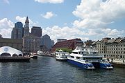
Passenger boat services

MBTA boat
The MBTA Boat system is a public boat service providing water transport in the Greater Boston area via Boston Harbor. Both inner harbor and longer distance commuter ferries are operated...
system comprises several ferry
Ferry
A ferry is a form of transportation, usually a boat, but sometimes a ship, used to carry primarily passengers, and sometimes vehicles and cargo as well, across a body of water. Most ferries operate on regular, frequent, return services...
routes on Boston Harbor
Boston Harbor
Boston Harbor is a natural harbor and estuary of Massachusetts Bay, and is located adjacent to the city of Boston, Massachusetts. It is home to the Port of Boston, a major shipping facility in the northeast.-History:...
. One of these is an inner harbor service, linking the downtown waterfront with Boston Navy Yard
Boston Navy Yard
The Boston Navy Yard, originally called the Charlestown Navy Yard and later Boston Naval Shipyard, was one of the oldest shipbuilding facilities in the United States Navy. Established in 1801, it was officially closed as an active naval installation on July 1, 1974, and the property was...
in Charlestown
Charlestown, Massachusetts
Charlestown is a neighborhood of Boston, Massachusetts, United States, and is located on a peninsula north of downtown Boston. Charlestown was originally a separate town and the first capital of the Massachusetts Bay Colony; it became a city in 1847 and was annexed by Boston on January 5, 1874...
. The other routes are commuter routes, linking downtown to Hingham
Hingham, Massachusetts
Hingham is a town in northern Plymouth County on the South Shore of the U.S. state of Massachusetts and suburb in Greater Boston. The United States Census Bureau 2008 estimated population was 22,561...
, Hull
Hull, Massachusetts
Hull is a peninsula town in Plymouth County, Massachusetts, United States. The population was 10,293 at the 2010 census. Hull is the smallest town by land area in Plymouth County and the fourth smallest in the state...
and Quincy
Quincy, Massachusetts
Quincy is a city in Norfolk County, Massachusetts, United States. Its nicknames are "City of Presidents", "City of Legends", and "Birthplace of the American Dream". As a major part of Metropolitan Boston, Quincy is a member of Boston's Inner Core Committee for the Metropolitan Area Planning Council...
. Some commuter services operate via Logan International Airport
Logan International Airport
General Edward Lawrence Logan International Airport is located in the East Boston neighborhood of Boston, Massachusetts . It covers , has six runways, and employs an estimated 16,000 people. It is the 19th busiest airport in the United States.Boston serves as a focus city for JetBlue Airways...
. All services are operated by private sector
Private sector
In economics, the private sector is that part of the economy, sometimes referred to as the citizen sector, which is run by private individuals or groups, usually as a means of enterprise for profit, and is not controlled by the state...
companies under contract to the MBTA.
Outside the MBTA system, seasonal passenger ferry services operate to the Boston Harbor Islands
Boston Harbor Islands National Recreation Area
The Boston Harbor Islands National Recreation Area is a National Recreation Area situated among the islands of Boston Harbor of Boston, Massachusetts. The area is made up of a collection of islands, together with a former island and a peninsula, many of which are open for public recreation and some...
, to the city of Salem
Salem, Massachusetts
Salem is a city in Essex County, Massachusetts, United States. The population was 40,407 at the 2000 census. It and Lawrence are the county seats of Essex County...
, and to the city of Provincetown
Provincetown, Massachusetts
Provincetown is a New England town located at the extreme tip of Cape Cod in Barnstable County, Massachusetts, United States. The population was 3,431 at the 2000 census, with an estimated 2007 population of 3,174...
on Cape Cod
Cape Cod
Cape Cod, often referred to locally as simply the Cape, is a cape in the easternmost portion of the state of Massachusetts, in the Northeastern United States...
. Water taxi
Water taxi
A water taxi or water bus, also known as a commuter boat, is a watercraft used to provide public transport, usually but not always in an urban environment. Service may be scheduled with multiple stops, operating in a similar manner to a bus, or on demand to many locations, operating in a similar...
s provide on-demand service from various points on the downtown waterfront and from Logan Airport
Logan International Airport
General Edward Lawrence Logan International Airport is located in the East Boston neighborhood of Boston, Massachusetts . It covers , has six runways, and employs an estimated 16,000 people. It is the 19th busiest airport in the United States.Boston serves as a focus city for JetBlue Airways...
, and in particular between the airport and downtown.
Several companies operate tourist oriented cruise boats on the harbor and on the Charles River
Charles River
The Charles River is an long river that flows in an overall northeasterly direction in eastern Massachusetts, USA. From its source in Hopkinton, the river travels through 22 cities and towns until reaching the Atlantic Ocean at Boston...
. Other companies operate duck tour
Duck tour
Duck tours, or DUKW tours, are tours that take place on purpose-built amphibious tour buses or military surplus DUKWs and LARC-Vs.Duck tours are primarily offered as tourist attractions in harbor, river and lake cities, such as Halifax, Albany, Austin, Baltimore, Chattanooga, Pittsburgh, Belfast,...
s that use amphibious vehicles, mostly derived from World War II
World War II
World War II, or the Second World War , was a global conflict lasting from 1939 to 1945, involving most of the world's nations—including all of the great powers—eventually forming two opposing military alliances: the Allies and the Axis...
era DUKW
DUKW
The DUKW is a six-wheel-drive amphibious truck that was designed by a partnership under military auspices of Sparkman & Stephens and General Motors Corporation during World War II for transporting goods and troops over land and water and for use approaching and crossing beaches in amphibious...
s, and encompass both the city's streets and its waterways. On a much smaller scale, but perhaps more iconic
Cultural icon
A cultural icon can be a symbol, logo, picture, name, face, person, building or other image that is readily recognized and generally represents an object or concept with great cultural significance to a wide cultural group...
of Boston, are the Swan Boats
Swan Boats (Boston, Massachusetts)
The Swan Boats are a fleet of pleasure boats operating on the lake of the Public Garden in Boston, Massachusetts. The boats have been operating since 1877, and have become a cultural icon for the city. They operate from April until September....
on the lake of the city's Public Garden.
Aviation
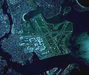
Logan International Airport
General Edward Lawrence Logan International Airport is located in the East Boston neighborhood of Boston, Massachusetts . It covers , has six runways, and employs an estimated 16,000 people. It is the 19th busiest airport in the United States.Boston serves as a focus city for JetBlue Airways...
, situated in East Boston
East Boston, Massachusetts
East Boston is a neighborhood of Boston, Massachusetts, with approximately 40,000 residents. The community was created by connecting several islands using landfill and was annexed by Boston in 1836. East Boston is separated from the rest of the city by Boston Harbor and bordered by Winthrop,...
just across inner Boston Harbor
Boston Harbor
Boston Harbor is a natural harbor and estuary of Massachusetts Bay, and is located adjacent to the city of Boston, Massachusetts. It is home to the Port of Boston, a major shipping facility in the northeast.-History:...
from downtown Boston. Logan Airport is operated by MassPort and has extensive domestic and international airline service. Logan Airport is linked to downtown by several highway tunnels. The Silver Line
Silver Line (MBTA)
The Silver Line is the only bus rapid transit line currently operated by the Massachusetts Bay Transportation Authority . It operates in two sections; the first runs from Dudley Square in Roxbury to downtown Boston, Massachusetts and South Station, mostly via Washington Street, with buses...
bus rapid transit
Bus rapid transit
Bus rapid transit is a term applied to a variety of public transportation systems using buses to provide faster, more efficient service than an ordinary bus line. Often this is achieved by making improvements to existing infrastructure, vehicles and scheduling...
uses these to connect Logan terminals with South Station
South Station
South Station, New England's second-largest transportation center , located at the intersection of Atlantic Avenue and Summer Street in Dewey Square, Boston, Massachusetts, is the largest train station and intercity bus terminal in Greater Boston, a prominent train station in the northeastern...
. There are also shuttle buses between the terminals and the Blue Line
Blue Line (MBTA)
The Blue Line is one of four subway lines of the Massachusetts Bay Transportation Authority serving Downtown, East Boston and the North Shore. It runs from northeast to southwest, extending from Wonderland station in Revere, Massachusetts to Bowdoin station near Beacon Hill in Boston...
Airport station
Airport (MBTA station)
Airport Station is a subway station on the Massachusetts Bay Transportation Authority's Blue Line. It serves as a mass transit connection to the nearby Logan International Airport...
.
To address overcrowding at Logan Airport, Massport has designated two out of state regional airports as reliever airports:
- T. F. Green AirportT. F. Green AirportT. F. Green Airport , also known as Theodore Francis Green State Airport, is a public airport located in Warwick, six miles south of Providence, in Kent County, Rhode Island, USA. Dedicated in 1931, the airport was named for former Rhode Island governor and longtime senator Theodore F. Green...
in ProvidenceProvidence, Rhode IslandProvidence is the capital and most populous city of Rhode Island and was one of the first cities established in the United States. Located in Providence County, it is the third largest city in the New England region...
, Rhode IslandRhode IslandThe state of Rhode Island and Providence Plantations, more commonly referred to as Rhode Island , is a state in the New England region of the United States. It is the smallest U.S. state by area... - Manchester-Boston Regional AirportManchester-Boston Regional AirportManchester-Boston Regional Airport , commonly referred to simply as "Manchester Airport," is a public airport located three miles south of the central business district of Manchester, New Hampshire on the county line of Hillsborough and Rockingham counties...
in ManchesterManchester, New HampshireManchester is the largest city in the U.S. state of New Hampshire, the tenth largest city in New England, and the largest city in northern New England, an area comprising the states of Maine, New Hampshire, and Vermont. It is in Hillsborough County along the banks of the Merrimack River, which...
, New HampshireNew HampshireNew Hampshire is a state in the New England region of the northeastern United States of America. The state was named after the southern English county of Hampshire. It is bordered by Massachusetts to the south, Vermont to the west, Maine and the Atlantic Ocean to the east, and the Canadian...
Massport does not operate these facilities. Train service has been allotted from T.F. Green to Boston.
There are also several general aviation
General aviation
General aviation is one of the two categories of civil aviation. It refers to all flights other than military and scheduled airline and regular cargo flights, both private and commercial. General aviation flights range from gliders and powered parachutes to large, non-scheduled cargo jet flights...
facilities in the Boston area including Hanscom Field
Hanscom Field
Hanscom Field , also known by its full name Laurence G. Hanscom Field, is a public airport located in Bedford, in Middlesex County, Massachusetts, United States. It is operated by the Massachusetts Port Authority....
, Norwood Memorial Airport
Norwood Memorial Airport
Norwood Memorial Airport is a public-use airport located two miles east of the central business district of Norwood, a town in Norfolk County, Massachusetts, United States. This airport is owned by the Town of Norwood...
and Beverly Municipal Airport
Beverly Municipal Airport
Beverly Municipal Airport is a public-use airport located three miles northwest of the central business district of Beverly, a city in Essex County, Massachusetts, United States...
. See also: List of airports in the Boston area.
Since September 11, 2001 attacks to the World Trade Center
World Trade Center
The original World Trade Center was a complex with seven buildings featuring landmark twin towers in Lower Manhattan, New York City, United States. The complex opened on April 4, 1973, and was destroyed in 2001 during the September 11 attacks. The site is currently being rebuilt with five new...
and the Pentagon
The Pentagon
The Pentagon is the headquarters of the United States Department of Defense, located in Arlington County, Virginia. As a symbol of the U.S. military, "the Pentagon" is often used metonymically to refer to the Department of Defense rather than the building itself.Designed by the American architect...
, exceptionally strict security has been implemented at all of Boston's airports. Because of this and its location as the closest American port to Europe, airliners that experience security breaches or disturbances while enroute to the U.S. are likely to be diverted to Boston, although they may also be diverted to Halifax, Nova Scotia
City of Halifax
Halifax is a city in Canada, which was the capital of the province of Nova Scotia and shire town of Halifax County. It was the largest city in Atlantic Canada until it was amalgamated into Halifax Regional Municipality in 1996...
, or other Canadian airports.
See also
- BostonBostonBoston is the capital of and largest city in Massachusetts, and is one of the oldest cities in the United States. The largest city in New England, Boston is regarded as the unofficial "Capital of New England" for its economic and cultural impact on the entire New England region. The city proper had...
, MassachusettsMassachusettsThe Commonwealth of Massachusetts is a state in the New England region of the northeastern United States of America. It is bordered by Rhode Island and Connecticut to the south, New York to the west, and Vermont and New Hampshire to the north; at its east lies the Atlantic Ocean. As of the 2010... - Transportation in Massachusetts
- MBTA accessibilityMBTA accessibilityPhysical accessibility on the Massachusetts Bay Transportation Authority system is incomplete but improving, with accessibility on all buses , all Orange Line stations, all but 2 Red Line stations, and all but 2 Blue Line stations...
- List of U.S. cities with most pedestrian commuters
- Greater BostonGreater BostonGreater Boston is the area of the Commonwealth of Massachusetts surrounding the city of Boston. Due to ambiguity in usage, the size of the area referred to can be anywhere between that of the metropolitan statistical area of Boston and that of the city's combined statistical area which includes...
for a wider scope
General
- http://members.aol.com/netransit/
- http://www.boston-online.com/Transportation/Trains/
- Car Free in Boston
- http://www.pathfriends.org/
- Chronology of subway construction in Boston