

Atlantic Avenue Elevated
Encyclopedia
Elevated railway
An elevated railway is a form of rapid transit railway with the tracks built above street level on some form of viaduct or other steel or concrete structure. The railway concerned may be constructed according to the standard gauge, narrow gauge, light rail, monorail or suspension railway system...
around the east side of downtown Boston, Massachusetts, providing a second route for the Boston Elevated Railway
Boston Elevated Railway
The Boston Elevated Railway was a precursor first to the Metropolitan Transit Authority in Massachusetts, now the Massachusetts Bay Transportation Authority, operating rapid transit, streetcars and buses in the Boston, Massachusetts area. It was formerly known as the West End Street Railway.The...
's Main Line (now the Orange Line
Orange Line (MBTA)
The Orange Line is one of the four subway lines of the Massachusetts Bay Transportation Authority. It extends from Forest Hills in Jamaica Plain, Boston in the south to Oak Grove in Malden, Massachusetts in the north. It meets the Red Line at Downtown Crossing, the Blue Line at State, and the Green...
) around the Washington Street Tunnel. It was in use from 1901 to 1938, and was demolished due to low ridership.
History
The Atlantic Ave El was conceived as a part of a greater mass transit proposal by the Boston Transit Commission in 1896. After the success of the Tremont Street SubwayTremont Street Subway
The Tremont Street Subway is a tunnel in Boston's subway system, and is the oldest subway tunnel in North America, opening on September 1, 1897. It was originally built as a tunnel to get streetcar lines off the streets, rather than a rapid transit line...
(now the Green Line
Green Line (MBTA)
The Green Line is a streetcar system run by the Massachusetts Bay Transportation Authority in the Boston, Massachusetts area of the United States. It is the oldest line of Boston's subway, which is known locally as the 'T'. The Green Line runs underground downtown and on the surface in outlying...
) the Commission began looking at options for a unified system that would serve all of downtown Boston and reach out into the growing suburbs. As conceived, there would be two corridors through which elevated trains would run: the Washington St Subway (now the Orange Line
Orange Line (MBTA)
The Orange Line is one of the four subway lines of the Massachusetts Bay Transportation Authority. It extends from Forest Hills in Jamaica Plain, Boston in the south to Oak Grove in Malden, Massachusetts in the north. It meets the Red Line at Downtown Crossing, the Blue Line at State, and the Green...
) under Washington St from a portal at Oak St to the existing subway portal after Haymarket Sq, and an all-elevated line which would run along Atlantic Ave
Atlantic Avenue (Boston)
Atlantic Avenue is a street in downtown Boston, Massachusetts, USA, partly serving as a frontage road for the underground Central Artery and partly running along the Boston Harbor...
. At the time Atlantic Ave was the heart of the fishing and maritime industries in Boston and home to ferry terminals. Both the Washington St Subway and Atlantic Ave El would service trains from the Main Line El (the elevated section of the old Orange Line, now demolished).
When the Atlantic Avenue El first opened, shortly after the Main Line in 1901, the Main Line went through the Tremont Street Subway , changing between elevated and subway
Rapid transit
A rapid transit, underground, subway, elevated railway, metro or metropolitan railway system is an electric passenger railway in an urban area with a high capacity and frequency, and grade separation from other traffic. Rapid transit systems are typically located either in underground tunnels or on...
at the Pleasant Street Incline
Pleasant Street Incline
The Pleasant Street Incline or Pleasant Street Portal was the southern access point for the Tremont Street Subway in Boston, Massachusetts, which later became part of the Green Line .-History:...
and the Causeway Street Incline. The low level trolley platforms were altered with temporary high-level platforms to allow for elevated trains to unload passengers. Where the original Washington Street Elevated
Washington Street Elevated
The Washington Street Elevated was an elevated segment of Boston's Massachusetts Bay Transportation Authority subway system, comprising the southern stretch of the Orange Line . It ran from Chinatown through the South End and Roxbury, ending in Forest Hills in Jamaica Plain...
(the south part of the Main Line) turned west from Washington Street
Washington Street (Boston)
Washington Street is a street originating in downtown Boston, Massachusetts that extends southwestward to the Massachusetts-Rhode Island state line. The majority of it was built as the Norfolk and Bristol Turnpike in the early nineteenth century...
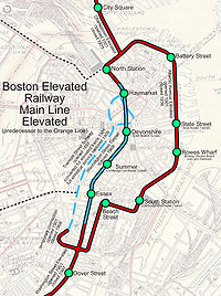
onto Castle Street (now Herald Street), it had a full three-way junction (Tower D) with the Atlantic Avenue El, which began by heading east between Motte Street (also part of Herald Street) and the New Haven Railroad tracks.
The El turned north after a block onto Harrison Avenue, continuing to Beach Street, where it turned east for its first station, Beach Street, on the block just east of Harrison Street. The El turned north on Atlantic Avenue
Atlantic Avenue (Boston)
Atlantic Avenue is a street in downtown Boston, Massachusetts, USA, partly serving as a frontage road for the underground Central Artery and partly running along the Boston Harbor...
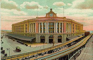
, with its second station, South Station, located just north of East Street, with transfers to the South Station
South Station
South Station, New England's second-largest transportation center , located at the intersection of Atlantic Avenue and Summer Street in Dewey Square, Boston, Massachusetts, is the largest train station and intercity bus terminal in Greater Boston, a prominent train station in the northeastern...
intercity and commuter terminal, and, beginning in 1916, to the Cambridge-Dorchester Tunnel (now the Red Line
Red Line (MBTA)
The Red Line is a rapid transit line operated by the MBTA running roughly north-south through Boston, Massachusetts into neighboring communities. The line begins west of Boston, in Cambridge, Massachusetts at Alewife station, near the intersection of Alewife Brook Parkway and Route 2...
). Next was Rowes Wharf at Broad Street and High Street, with a transfer to the Boston, Revere Beach and Lynn Railroad
Boston, Revere Beach and Lynn Railroad
The Boston, Revere Beach and Lynn Railroad is a historic railroad that operated in Massachusetts.It was constructed as an 8.8-mile gauge narrow gauge passenger-carrying railroad to serve the Boston area....
via a ferry
Ferry
A ferry is a form of transportation, usually a boat, but sometimes a ship, used to carry primarily passengers, and sometimes vehicles and cargo as well, across a body of water. Most ferries operate on regular, frequent, return services...
from Rowe's Wharf to East Boston.
Continuing along Atlantic Avenue, the next station, at State Street, was named State Street and had, beginning in 1904, a transfer to the East Boston Tunnel (now the Blue Line
Blue Line (MBTA)
The Blue Line is one of four subway lines of the Massachusetts Bay Transportation Authority serving Downtown, East Boston and the North Shore. It runs from northeast to southwest, extending from Wonderland station in Revere, Massachusetts to Bowdoin station near Beacon Hill in Boston...
). After merging with Commercial Street, Battery Street Station, just north of Battery Street, provided access to Boston's North End. Just south of Battery Street, on the east side, was the Boston Elevated Railway
Boston Elevated Railway
The Boston Elevated Railway was a precursor first to the Metropolitan Transit Authority in Massachusetts, now the Massachusetts Bay Transportation Authority, operating rapid transit, streetcars and buses in the Boston, Massachusetts area. It was formerly known as the West End Street Railway.The...
's Lincoln Wharf Power Station. At Keany Square, the Atlantic Avenue Elevated ended at the Charlestown Elevated
Charlestown Elevated
The Charlestown Elevated was a former link of Boston's Orange Line rapid transit line that ran from a portal at North Station, near the old Boston Garden, to the city of Everett, Massachusetts...
, the north part of the Main Line, at a full three-way junction (Tower C), with the Charlestown El heading west on Causeway Street and north over the Charlestown Bridge.
In 1908, the Washington Street Tunnel opened, rerouting the Main Line. At this time the Tremont St Subway was switched back to trolley-only service. As a consequence, the southern junction (Tower D) was reconfigured, with the Main Line heading north from it on the east side of Washington Street
Washington Street (Boston)
Washington Street is a street originating in downtown Boston, Massachusetts that extends southwestward to the Massachusetts-Rhode Island state line. The majority of it was built as the Norfolk and Bristol Turnpike in the early nineteenth century...
to the incline into the tunnel.
Service patterns included through service over the Main Line and additional Washington Street Elevated
Washington Street Elevated
The Washington Street Elevated was an elevated segment of Boston's Massachusetts Bay Transportation Authority subway system, comprising the southern stretch of the Orange Line . It ran from Chinatown through the South End and Roxbury, ending in Forest Hills in Jamaica Plain...
service looping via the tunnel one way and the El the other way. The El south of South Station was closed following a fatal wreck at the tight curve at Harrison and Beach in July 1928, and all service became a shuttle
Public transport
Public transport is a shared passenger transportation service which is available for use by the general public, as distinct from modes such as taxicab, car pooling or hired buses which are not shared by strangers without private arrangement.Public transport modes include buses, trolleybuses, trams...
between there and North Station on the Charlestown Elevated
Charlestown Elevated
The Charlestown Elevated was a former link of Boston's Orange Line rapid transit line that ran from a portal at North Station, near the old Boston Garden, to the city of Everett, Massachusetts...
.
In 1919, the Boston molasses disaster
Boston molasses disaster
The Boston Molasses Disaster, also known as the Great Molasses Flood and the Great Boston Molasses Tragedy, occurred on January 15, 1919, in the North End neighborhood of Boston, Massachusetts in the United States. A large molasses storage tank burst, and a wave of molasses rushed through the...
resulted in damage to the El in the area north of Battery Street.
In the early 1920s the fishing and maritime industries in Boston hit hard times and passenger loads along the Atlantic Ave El dropped. With the construction of the Sumner Tunnel
Sumner Tunnel
The Sumner Tunnel is a road tunnel in Boston, Massachusetts, USA. It carries traffic under Boston Harbor in one direction, from Logan International Airport and Route 1A in East Boston. The tunnel originally deposited traffic at the west side of the North End but with the completion of the Big Dig,...
and the cessation of ferry service on Boston Harbor, ridership between North and South Station dropped precipitously. This part of the line was closed on October 1, 1938, and torn down in 1942 for scrap metal
Scrap Metal
Scrap Metal were a band from Broome, Western Australia who played rock music with elements of country and reggae. The members had Aboriginal, Irish, Filipino, French, Chinese, Scottish, Indonesian and Japanese heritage. The band toured nationally as part of the Bran Nue Dae musical and with...
for World War II
World War II
World War II, or the Second World War , was a global conflict lasting from 1939 to 1945, involving most of the world's nations—including all of the great powers—eventually forming two opposing military alliances: the Allies and the Axis...
.
The Union Freight Railroad
Union Freight Railroad
The Union Freight Railroad was a freight-only railroad connecting the railroads coming into the north and south sides of downtown Boston, Massachusetts. Almost its entire length was along Atlantic Avenue and Commercial Street...
ran underneath the El on Atlantic Avenue
Atlantic Avenue (Boston)
Atlantic Avenue is a street in downtown Boston, Massachusetts, USA, partly serving as a frontage road for the underground Central Artery and partly running along the Boston Harbor...
and Commercial Street, carrying freight between the lines terminating in North Station and South Station
South Station
South Station, New England's second-largest transportation center , located at the intersection of Atlantic Avenue and Summer Street in Dewey Square, Boston, Massachusetts, is the largest train station and intercity bus terminal in Greater Boston, a prominent train station in the northeastern...
.