
.gif)
Blue Line (MBTA)
Encyclopedia
The Blue Line is one of four subway
lines of the Massachusetts Bay Transportation Authority
(MBTA) serving Downtown, East Boston and the North Shore. It runs from northeast to southwest, extending from Wonderland station
in Revere, Massachusetts
to Bowdoin station
near Beacon Hill
in Boston. It meets the Green Line
at Government Center
, connects with the Orange Line
at State Street
, and provides service to Airport station
which has a free shuttle connection to Logan International Airport
.
The Blue Line is the only MBTA subway line to serve only a single district in the State Senate
— the First Middlesex and Suffolk district.
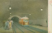
The East Boston Tunnel, opened in 1904, was the first subway in the world to run underneath a section of the ocean. It was initially designed to carry streetcar
s, and ran from Maverick to Court Street via State. In 1906, Atlantic Station (now Aquarium) was opened, with a connection to the Atlantic Avenue Elevated
. In 1916, the terminus at Court Street was moved to Bowdoin, and the Scollay Square
station (now Government Center) was opened near the closed Court Street station.
In 1925, the subway portion of the line was retrofitted for high platform
service, and rapid transit
cars began shuttling between Bowdoin and Maverick. From 1952 to 1954, a surface extension was created along the disused Boston, Revere Beach and Lynn Railroad
, from Maverick to the current terminus at Wonderland. The old railroad was narrow gauge
, but was converted to standard gauge
for this Revere Extension of the subway.
The line, officially known as the East Boston Tunnel & Revere Extension by the MTA since 1952, was redesignated Blue on August 26, 1965 as part of the new MBTA's color-based re-branding. The color blue represented water, as the line passes under Boston Harbor
and travels near the coast for much of its length.
In the early part of the 20th century, the Blue Line was actually connected to the Red Line
by a direct rail connection (though the color designations of the subway lines had yet to be assigned at that time). Rail cars from the Blue Line could emerge from a ramp portal surfacing between Joy Street and Russell Street, just beyond Bowdoin
station, and run on tracks down Cambridge Street to connect to the Red Line near what is now Charles/MGH
station. Because the tracks were unpowered, individual cars had to be towed along the street at night. This connection was never used in revenue service
, but was used to transport Blue Line cars to the Eliot Street Yard maintenance shops then located near Harvard Square station. When the Blue Line eventually got its own maintenance shops, the connection was removed and the ramp portal was permanently covered around 1952.
As of 2011, there are plans to rebuild this historic Red/Blue Line connection, but in a more permanent manner. The new connection would be entirely underground, with no direct track connection — passengers would transfer at Charles/MGH inside a fare paid area.
As of 2011, passengers can disembark from all 6 cars at the outbound platform of Bowdoin Station
, but due to the shape of the platform (which is inside a turn-around loop), passengers can only board 4 cars at the inbound side. The MBTA uses "POP buttons" on the outside of 6-car trains to allow passengers to open only the doors they need to board. The station may eventually be closed or reconfigured as part of the Red Line Blue Line Connector project, as discussed below.
. The land to extend the line was purchased for the initial construction of the Revere Extension, but due to budgetary constraints Wonderland station was designated the northern terminus. Two potential extension routes have been identified. One proposed path would run through marshland alongside the existing Newburyport/Rockport commuter rail line
, on rail lines formerly operated by the Boston and Maine Railroad
. An alternative route would extend the line alongside Revere Beach Boulevard
through Point of Pines and the Lynnway
, along the remainder of the BRB&L right of way. Other alternatives include increased commuter rail or bus service, or connecting the Blue Line to a commuter rail stop near Wonderland via a short connector.
In 2005, Lieutenant Governor
Kerry Healy estimated construction would begin in 2017. Authorization to bond for planning money for the project was included in an April 2008 state bond bill, and $25 million in federal earmarks have been obtained. A 2004 state bond bill authorized $246.5 million on the condition of finding 50% non-state matching funds (which presumably would come from the federal government). The Draft Environmental Impact Report was expected to be complete by the end of 2008, but has been delayed as planners focus on meeting the legal deadline for the Green Line extension to Somerville and Medford.
is the most convenient way to transfer between the Blue Line and the Red Line
, thus causing the short Green Line segment between Government Center
station and nearby Park Street
station to be especially congested during peak travel times. This bottleneck, combined with tight platform clearances on the Green Line outbound side, has been the cause of significant delays and crowding on the Green Line. In the past, an underground pedestrian passage had been proposed, paralleling the Green Line tracks and connecting the two stations, but this idea was dropped in favor of a direct transfer connection between the Blue and Red Lines.
It also is possible to transfer between the Red and Blue Lines by traveling one stop on the Orange Line
between State
and Downtown Crossing
stations, but this path involves navigating a longer and more convoluted path through stairs and passages of those stations. The Red and Blue Lines are the only pair of rapid transit lines in the MBTA system that lack a direct transfer connection. The idea of connecting them was studied in the Boston Transportation Planning Review
in 1972.
As part of a lawsuit settlement relating to air quality mitigation for the Big Dig
highway tunnel project, the Commonwealth of Massachusetts agreed to build a direct transfer connection between the Blue and Red Lines. This would be done by extending the Blue Line beyond Bowdoin
station, continuing to run a further 1500 feet (450 m) beneath Cambridge Street to Charles/MGH
station on the Red Line. Unlike the historic Red/Blue Line connection described earlier, there would be no direct rail connection between lines at Charles/MGH station (the rail gauges are identical, but the Red and Blue Line railcars are otherwise dimensionally incompatible). However, passengers would be able to transfer between the Red and Blue Lines without needing to crowd onto the Green Line, and many passengers from the North Shore of Boston would be able to reach the Massachusetts General Hospital
area directly without further transfers.
After failing to take any action for over a decade, and under threat of further lawsuits, the state finally agreed to start detailed engineering design for such an extension, which is ongoing as of 2011. Construction is expected to take 6 years, but a start date and funding scheme have not yet been announced.
 Like all MBTA lines, the Blue Line tracks are standard gauge
heavy rail.
Blue Line cars are unique among rapid transit vehicles in Boston, in that they use both third rail
power and pantograph
current pickup from overhead catenary wires. Trains switch between the two modes at Airport station
, near where the line transitions between running in a tunnel and running above ground. Previously, the switchover was made underground at Maverick station, but the temporary loss of power and lighting during switchover is less disconcerting above ground. The overhead pantograph was implemented to avoid third rail icing that frequently occurs in winter. Third rail power is used in the original Blue Line tunnels, which are smaller than most modern subway tunnels.
The Blue Line cars are also narrower and shorter than otherwise similar ones running on the Orange Line, due to the stations and tunnels on the former line having been originally designed to accommodate streetcars.
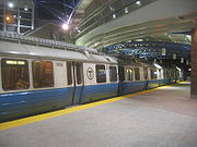
The Blue Line fleet consists mainly of 94 700-series cars (47 pairs) with stainless steel
bodies from Siemens
, with each car 48 feet (14.9m) long and 9 feet 3 inches wide (2.8m), with two pairs of doors per side. The cars are of a similar design to those built for the Tren Urbano
system in San Juan, Puerto Rico
, also designed by Siemens. Originally scheduled to be delivered beginning in January, 2004, the development of the trains has been beset with problems. The contract price of the cars is $174 million, with a total cost to the MBTA (including engineering and other related services) of $200 million.
Twenty of the older 600-series cars are also still in operable condition, though as of June 2010 they are only kept as a contingency fleet and are not in everyday use. Previously, all of the fleet consisted of the 0600 series, built 1978-1980 by Hawker Siddeley Canada Car and Foundry (now Bombardier Transportation
) of Thunder Bay, Ontario
, Canada
. They are 48 feet 10 inches (14.9 m) long and 9 feet 3 inches (2.8 m) wide, with two pairs of doors on each side, and a design maximum speed of 65 mph (105 km/h). They are based on the PA3 model used by PATH
in New Jersey
. There were originally 70 Hawker cars, numbered 0600-0669. As of 2011, most of these cars have been retired because of severe corrosion, mainly caused by the salty air that results from much of the line being very close to the ocean. However, 12-20 cars will be retained until 2012. Seashore Trolley Museum
received set 622-623 for their collection.
Rapid transit
A rapid transit, underground, subway, elevated railway, metro or metropolitan railway system is an electric passenger railway in an urban area with a high capacity and frequency, and grade separation from other traffic. Rapid transit systems are typically located either in underground tunnels or on...
lines of the Massachusetts Bay Transportation Authority
Massachusetts Bay Transportation Authority
The Massachusetts Bay Transportation Authority, often referred to as the MBTA or simply The T, is the public operator of most bus, subway, commuter rail and ferry systems in the greater Boston, Massachusetts, area. Officially a "body politic and corporate, and a political subdivision" of the...
(MBTA) serving Downtown, East Boston and the North Shore. It runs from northeast to southwest, extending from Wonderland station
Wonderland (MBTA station)
Wonderland is the northern terminus of the Blue Line in the Massachusetts Bay Transportation Authority mass transit system serving greater Boston. The station is located near the site of the now-closed Wonderland Greyhound Park in Revere, Massachusetts, and is handicapped accessible. See MBTA...
in Revere, Massachusetts
Revere, Massachusetts
Revere is a city in Suffolk County, Massachusetts, United States, and located approximately from downtown Boston. It is named after the American patriot Paul Revere. As of the 2010 census, the city population was 51,755.- History :...
to Bowdoin station
Bowdoin (MBTA station)
Bowdoin of the MBTA, is a station on the Blue Line, serving Bowdoin Square in Boston's Beacon Hill neighborhood. It is currently the downtown terminus of the line, although it may close if the line is extended or after Government Center is rebuilt.-History:...
near Beacon Hill
Beacon Hill, Boston, Massachusetts
Beacon Hill is a historic neighborhood of Boston, Massachusetts, that along with the neighboring Back Bay is home to about 26,000 people. It is a neighborhood of Federal-style rowhouses and is known for its narrow, gas-lit streets and brick sidewalks...
in Boston. It meets the Green Line
Green Line (MBTA)
The Green Line is a streetcar system run by the Massachusetts Bay Transportation Authority in the Boston, Massachusetts area of the United States. It is the oldest line of Boston's subway, which is known locally as the 'T'. The Green Line runs underground downtown and on the surface in outlying...
at Government Center
Government Center (MBTA station)
Government Center is an MBTA subway station and a transfer point between the Green Line and the Blue Line. It is located at the intersection of Tremont, Court and Cambridge Streets in the Government Center area of Boston.-History:...
, connects with the Orange Line
Orange Line (MBTA)
The Orange Line is one of the four subway lines of the Massachusetts Bay Transportation Authority. It extends from Forest Hills in Jamaica Plain, Boston in the south to Oak Grove in Malden, Massachusetts in the north. It meets the Red Line at Downtown Crossing, the Blue Line at State, and the Green...
at State Street
State (MBTA station)
State, well known as State Street, is a subway station of the Massachusetts Bay Transportation Authority. Located in downtown Boston, Massachusetts, State is the transfer point between the Orange Line and the Blue Line.-Description:...
, and provides service to Airport station
Airport (MBTA station)
Airport Station is a subway station on the Massachusetts Bay Transportation Authority's Blue Line. It serves as a mass transit connection to the nearby Logan International Airport...
which has a free shuttle connection to Logan International Airport
Logan International Airport
General Edward Lawrence Logan International Airport is located in the East Boston neighborhood of Boston, Massachusetts . It covers , has six runways, and employs an estimated 16,000 people. It is the 19th busiest airport in the United States.Boston serves as a focus city for JetBlue Airways...
.
The Blue Line is the only MBTA subway line to serve only a single district in the State Senate
Massachusetts Senate
The Massachusetts Senate is the upper house of the Massachusetts General Court, the bicameral state legislature of the Commonwealth of Massachusetts. The Senate comprises 40 elected members from 40 single-member senatorial districts in the state...
— the First Middlesex and Suffolk district.
History
The East Boston Tunnel, opened in 1904, was the first subway in the world to run underneath a section of the ocean. It was initially designed to carry streetcar
Light rail
Light rail or light rail transit is a form of urban rail public transportation that generally has a lower capacity and lower speed than heavy rail and metro systems, but higher capacity and higher speed than traditional street-running tram systems...
s, and ran from Maverick to Court Street via State. In 1906, Atlantic Station (now Aquarium) was opened, with a connection to the Atlantic Avenue Elevated
Atlantic Avenue Elevated
The Atlantic Avenue Elevated was an elevated railway around the east side of downtown Boston, Massachusetts, providing a second route for the Boston Elevated Railway's Main Line around the Washington Street Tunnel...
. In 1916, the terminus at Court Street was moved to Bowdoin, and the Scollay Square
Scollay Square
Scollay Square was a vibrant city square in downtown Boston, Massachusetts. It was named for William Scollay, a prominent local developer and militia officer who bought a landmark four-story merchant building at the intersection of Cambridge and Court Streets in 1795...
station (now Government Center) was opened near the closed Court Street station.
In 1925, the subway portion of the line was retrofitted for high platform
Railway platform height
On a railway the platform height refers to the height of a platform above the rail. The value varies between railway systems. A related term is "train floor height" which is the height of the floor of the rail vehicle. There are a wide number of standards for platform heights and train floor heights...
service, and rapid transit
Rapid transit
A rapid transit, underground, subway, elevated railway, metro or metropolitan railway system is an electric passenger railway in an urban area with a high capacity and frequency, and grade separation from other traffic. Rapid transit systems are typically located either in underground tunnels or on...
cars began shuttling between Bowdoin and Maverick. From 1952 to 1954, a surface extension was created along the disused Boston, Revere Beach and Lynn Railroad
Boston, Revere Beach and Lynn Railroad
The Boston, Revere Beach and Lynn Railroad is a historic railroad that operated in Massachusetts.It was constructed as an 8.8-mile gauge narrow gauge passenger-carrying railroad to serve the Boston area....
, from Maverick to the current terminus at Wonderland. The old railroad was narrow gauge
Narrow gauge
A narrow gauge railway is a railway that has a track gauge narrower than the of standard gauge railways. Most existing narrow gauge railways have gauges of between and .- Overview :...
, but was converted to standard gauge
Standard gauge
The standard gauge is a widely-used track gauge . Approximately 60% of the world's existing railway lines are built to this gauge...
for this Revere Extension of the subway.
The line, officially known as the East Boston Tunnel & Revere Extension by the MTA since 1952, was redesignated Blue on August 26, 1965 as part of the new MBTA's color-based re-branding. The color blue represented water, as the line passes under Boston Harbor
Boston Harbor
Boston Harbor is a natural harbor and estuary of Massachusetts Bay, and is located adjacent to the city of Boston, Massachusetts. It is home to the Port of Boston, a major shipping facility in the northeast.-History:...
and travels near the coast for much of its length.
In the early part of the 20th century, the Blue Line was actually connected to the Red Line
Red Line (MBTA)
The Red Line is a rapid transit line operated by the MBTA running roughly north-south through Boston, Massachusetts into neighboring communities. The line begins west of Boston, in Cambridge, Massachusetts at Alewife station, near the intersection of Alewife Brook Parkway and Route 2...
by a direct rail connection (though the color designations of the subway lines had yet to be assigned at that time). Rail cars from the Blue Line could emerge from a ramp portal surfacing between Joy Street and Russell Street, just beyond Bowdoin
Bowdoin (MBTA station)
Bowdoin of the MBTA, is a station on the Blue Line, serving Bowdoin Square in Boston's Beacon Hill neighborhood. It is currently the downtown terminus of the line, although it may close if the line is extended or after Government Center is rebuilt.-History:...
station, and run on tracks down Cambridge Street to connect to the Red Line near what is now Charles/MGH
Charles/MGH (MBTA station)
Charles/MGH Station also known as Charles or Charles Street, is located at the intersection of Cambridge Street and Charles Street, in Boston, Massachusetts. The rapid transit station is on the MBTA Red Line and is elevated, being located at the Boston side of the Longfellow Bridge, which carries...
station. Because the tracks were unpowered, individual cars had to be towed along the street at night. This connection was never used in revenue service
Revenue service
A revenue service is a government agency responsible for the intake of government revenue, including taxes and sometimes non-tax revenue. Depending on the jurisdiction, revenue services may be charged with tax collection, investigation of tax evasion, or carrying out audits.-Revenue services by...
, but was used to transport Blue Line cars to the Eliot Street Yard maintenance shops then located near Harvard Square station. When the Blue Line eventually got its own maintenance shops, the connection was removed and the ramp portal was permanently covered around 1952.
As of 2011, there are plans to rebuild this historic Red/Blue Line connection, but in a more permanent manner. The new connection would be entirely underground, with no direct track connection — passengers would transfer at Charles/MGH inside a fare paid area.
Station renovations
The Blue Line Modernization Project begun in the late 1990s includes renovating stations to increase the length of trains from four to six cars, to make all stations wheelchair accessible, and to improve appearance. The first Blue Line six-car trains began service on September 15, 2008.As of 2011, passengers can disembark from all 6 cars at the outbound platform of Bowdoin Station
Bowdoin (MBTA station)
Bowdoin of the MBTA, is a station on the Blue Line, serving Bowdoin Square in Boston's Beacon Hill neighborhood. It is currently the downtown terminus of the line, although it may close if the line is extended or after Government Center is rebuilt.-History:...
, but due to the shape of the platform (which is inside a turn-around loop), passengers can only board 4 cars at the inbound side. The MBTA uses "POP buttons" on the outside of 6-car trains to allow passengers to open only the doors they need to board. The station may eventually be closed or reconfigured as part of the Red Line Blue Line Connector project, as discussed below.
Extension to Lynn
There is a proposal to extend the Blue Line northward to Lynn, MassachusettsLynn, Massachusetts
Lynn is a city in Essex County, Massachusetts, United States. The population was 89,050 at the 2000 census. An old industrial center, Lynn is home to Lynn Beach and Lynn Heritage State Park and is about north of downtown Boston.-17th century:...
. The land to extend the line was purchased for the initial construction of the Revere Extension, but due to budgetary constraints Wonderland station was designated the northern terminus. Two potential extension routes have been identified. One proposed path would run through marshland alongside the existing Newburyport/Rockport commuter rail line
Newburyport/Rockport Line
The Newburyport/Rockport Line is a branch of the MBTA Commuter Rail system, running northeast from downtown Boston, Massachusetts towards Cape Ann and the Merrimack Valley, serving the North Shore. The first leg serves Chelsea, Lynn, Swampscott, Salem, and Beverly. From there, a northern branch of...
, on rail lines formerly operated by the Boston and Maine Railroad
Boston and Maine Railroad
The Boston and Maine Corporation , known as the Boston and Maine Railroad until 1964, was the dominant railroad of the northern New England region of the United States for a century...
. An alternative route would extend the line alongside Revere Beach Boulevard
Revere Beach
Revere Beach is a public beach in Revere, Massachusetts. Located about 4 miles north of downtown Boston, the beach, founded in 1895, is the first public beach in the country. In the past, it was known as the Coney Island of New England...
through Point of Pines and the Lynnway
Massachusetts Route 1A
Route 1A is a south–north state highway in Massachusetts. It is an alternate route to U.S. 1 with three signed sections and two unsigned sections where the highway is concurrent with its parent...
, along the remainder of the BRB&L right of way. Other alternatives include increased commuter rail or bus service, or connecting the Blue Line to a commuter rail stop near Wonderland via a short connector.
In 2005, Lieutenant Governor
Lieutenant Governor of Massachusetts
The Lieutenant Governor of Massachusetts is the first in the line to discharge the powers and duties of the office of governor following the incapacitation of the Governor of Massachusetts...
Kerry Healy estimated construction would begin in 2017. Authorization to bond for planning money for the project was included in an April 2008 state bond bill, and $25 million in federal earmarks have been obtained. A 2004 state bond bill authorized $246.5 million on the condition of finding 50% non-state matching funds (which presumably would come from the federal government). The Draft Environmental Impact Report was expected to be complete by the end of 2008, but has been delayed as planners focus on meeting the legal deadline for the Green Line extension to Somerville and Medford.
Red Line-Blue Line Connector
As of 2011, the Green LineGreen Line (MBTA)
The Green Line is a streetcar system run by the Massachusetts Bay Transportation Authority in the Boston, Massachusetts area of the United States. It is the oldest line of Boston's subway, which is known locally as the 'T'. The Green Line runs underground downtown and on the surface in outlying...
is the most convenient way to transfer between the Blue Line and the Red Line
Red Line (MBTA)
The Red Line is a rapid transit line operated by the MBTA running roughly north-south through Boston, Massachusetts into neighboring communities. The line begins west of Boston, in Cambridge, Massachusetts at Alewife station, near the intersection of Alewife Brook Parkway and Route 2...
, thus causing the short Green Line segment between Government Center
Government Center (MBTA station)
Government Center is an MBTA subway station and a transfer point between the Green Line and the Blue Line. It is located at the intersection of Tremont, Court and Cambridge Streets in the Government Center area of Boston.-History:...
station and nearby Park Street
Park Street (MBTA station)
Park Street is a rapid transit and light rail station of the MBTA subway system in Downtown Boston. One of the four subway hub stations, Park Street is a transfer point between the Green and Red Lines. Park Street is the fourth-busiest station in the MBTA network, with an average of 19,836 entries...
station to be especially congested during peak travel times. This bottleneck, combined with tight platform clearances on the Green Line outbound side, has been the cause of significant delays and crowding on the Green Line. In the past, an underground pedestrian passage had been proposed, paralleling the Green Line tracks and connecting the two stations, but this idea was dropped in favor of a direct transfer connection between the Blue and Red Lines.
It also is possible to transfer between the Red and Blue Lines by traveling one stop on the Orange Line
Orange Line (MBTA)
The Orange Line is one of the four subway lines of the Massachusetts Bay Transportation Authority. It extends from Forest Hills in Jamaica Plain, Boston in the south to Oak Grove in Malden, Massachusetts in the north. It meets the Red Line at Downtown Crossing, the Blue Line at State, and the Green...
between State
State (MBTA station)
State, well known as State Street, is a subway station of the Massachusetts Bay Transportation Authority. Located in downtown Boston, Massachusetts, State is the transfer point between the Orange Line and the Blue Line.-Description:...
and Downtown Crossing
Downtown Crossing (MBTA station)
Downtown Crossing Station of the MBTA, located at the corner of Washington Street and Summer Street and the corner of Chauncey Street and Summer Street in Boston, is the main transfer point between the Orange Line and the Red Line....
stations, but this path involves navigating a longer and more convoluted path through stairs and passages of those stations. The Red and Blue Lines are the only pair of rapid transit lines in the MBTA system that lack a direct transfer connection. The idea of connecting them was studied in the Boston Transportation Planning Review
Boston Transportation Planning Review
Boston Transportation Planning Review is a transportation planning program for metropolitan Boston, United States which was responsible for analyzing and re-designing the entire area-wide transit and highway system in the 1970s. The major contractors involved were Alan M...
in 1972.
As part of a lawsuit settlement relating to air quality mitigation for the Big Dig
Big Dig
The Central Artery/Tunnel Project , known unofficially as the Big Dig and as the Big Dug since completion, was a megaproject in Boston that rerouted the Central Artery , the chief highway through the heart of the city, into a 3.5-mile tunnel...
highway tunnel project, the Commonwealth of Massachusetts agreed to build a direct transfer connection between the Blue and Red Lines. This would be done by extending the Blue Line beyond Bowdoin
Bowdoin (MBTA station)
Bowdoin of the MBTA, is a station on the Blue Line, serving Bowdoin Square in Boston's Beacon Hill neighborhood. It is currently the downtown terminus of the line, although it may close if the line is extended or after Government Center is rebuilt.-History:...
station, continuing to run a further 1500 feet (450 m) beneath Cambridge Street to Charles/MGH
Charles/MGH (MBTA station)
Charles/MGH Station also known as Charles or Charles Street, is located at the intersection of Cambridge Street and Charles Street, in Boston, Massachusetts. The rapid transit station is on the MBTA Red Line and is elevated, being located at the Boston side of the Longfellow Bridge, which carries...
station on the Red Line. Unlike the historic Red/Blue Line connection described earlier, there would be no direct rail connection between lines at Charles/MGH station (the rail gauges are identical, but the Red and Blue Line railcars are otherwise dimensionally incompatible). However, passengers would be able to transfer between the Red and Blue Lines without needing to crowd onto the Green Line, and many passengers from the North Shore of Boston would be able to reach the Massachusetts General Hospital
Massachusetts General Hospital
Massachusetts General Hospital is a teaching hospital and biomedical research facility in the West End neighborhood of Boston, Massachusetts...
area directly without further transfers.
After failing to take any action for over a decade, and under threat of further lawsuits, the state finally agreed to start detailed engineering design for such an extension, which is ongoing as of 2011. Construction is expected to take 6 years, but a start date and funding scheme have not yet been announced.
Station listing
| Station | Time to Government Center | Opened | Transfers and notes |
|---|---|---|---|
| Wonderland Wonderland (MBTA station) Wonderland is the northern terminus of the Blue Line in the Massachusetts Bay Transportation Authority mass transit system serving greater Boston. The station is located near the site of the now-closed Wonderland Greyhound Park in Revere, Massachusetts, and is handicapped accessible. See MBTA... |
21 minutes | January 19, 1954 | Site of former Boston, Revere Beach and Lynn Railroad Boston, Revere Beach and Lynn Railroad The Boston, Revere Beach and Lynn Railroad is a historic railroad that operated in Massachusetts.It was constructed as an 8.8-mile gauge narrow gauge passenger-carrying railroad to serve the Boston area.... Bathhouse Station |
| Revere Beach Revere Beach (MBTA station) Revere Beach Station of the MBTA, is a station on the Blue Line, serving the city of Revere, Massachusetts. It was built between 1952 and 1954 as part of the Blue Line extension to Wonderland, on the site of a former Boston, Revere Beach and Lynn Railroad station. True to its name, Revere Beach... |
19 minutes | January 19, 1954 | Site of former Boston, Revere Beach and Lynn Railroad Boston, Revere Beach and Lynn Railroad The Boston, Revere Beach and Lynn Railroad is a historic railroad that operated in Massachusetts.It was constructed as an 8.8-mile gauge narrow gauge passenger-carrying railroad to serve the Boston area.... Crescent Beach Station |
| Beachmont Beachmont (MBTA station) Beachmont is an above-ground rapid-transit station located on the MBTA Blue Line. This station serves the Beachmont neighborhood of Revere, Massachusetts.The station was closed for approximately one year starting on June 25, 1994, as the station was rebuilt... |
17 minutes | January 19, 1954 | Elevated above the site of formerly at-grade Boston, Revere Beach and Lynn Railroad Boston, Revere Beach and Lynn Railroad The Boston, Revere Beach and Lynn Railroad is a historic railroad that operated in Massachusetts.It was constructed as an 8.8-mile gauge narrow gauge passenger-carrying railroad to serve the Boston area.... Beachmont station |
| Suffolk Downs Suffolk Downs (MBTA station) Suffolk Downs is a station on the Massachusetts Bay Transportation Authority's Blue Line, which runs between Bowdoin station, near Beacon Hill in Boston, and the Wonderland station in Revere, Massachusetts... |
15 minutes | April 21, 1952 | Site of former Boston, Revere Beach and Lynn Railroad Boston, Revere Beach and Lynn Railroad The Boston, Revere Beach and Lynn Railroad is a historic railroad that operated in Massachusetts.It was constructed as an 8.8-mile gauge narrow gauge passenger-carrying railroad to serve the Boston area.... Belle Isle Station and adjacent to former street car terminal |
| Orient Heights Orient Heights (MBTA station) Orient Heights is a station on the MBTA Blue Line in East Boston, MA. It is located on the above-ground section of the line that uses overhead lines instead of third rail.... |
13 minutes | January 5, 1952 | Site of former Boston, Revere Beach and Lynn Railroad Boston, Revere Beach and Lynn Railroad The Boston, Revere Beach and Lynn Railroad is a historic railroad that operated in Massachusetts.It was constructed as an 8.8-mile gauge narrow gauge passenger-carrying railroad to serve the Boston area.... Orient Heights Station |
| Wood Island Wood Island (MBTA station) Wood Island is a grade-level, open-air rapid transit bus and train station on the MBTA Blue Line and is on the part of the Blue Line that uses overhead lines instead of third rail. Located on Bennington Street in the neighborhood of East Boston, the station's primary patrons are residents of the... |
11 minutes | January 5, 1952 | Formerly Day Square, renamed Wood Island Park October 21, 1954, renamed Wood Island 1967 |
| Airport Airport (MBTA station) Airport Station is a subway station on the Massachusetts Bay Transportation Authority's Blue Line. It serves as a mass transit connection to the nearby Logan International Airport... |
9 minutes | June 3, 2004 | Replaced older station a few hundred feet south of current station. Old station opened January 5, 1952 and closed June 2, 2004. Connection to the Silver Line Silver Line (MBTA) The Silver Line is the only bus rapid transit line currently operated by the Massachusetts Bay Transportation Authority . It operates in two sections; the first runs from Dudley Square in Roxbury to downtown Boston, Massachusetts and South Station, mostly via Washington Street, with buses... via the Massport Shuttle to the Airport Terminals. |
| Maverick Maverick (MBTA station) Maverick is a subway station on the Blue Line at Maverick Square in East Boston, Massachusetts, USA. It is the easternmost underground station on the Blue Line, and a transfer point to various buses. One center island platform provides access to the surface in the middle of Maverick Square... |
7 minutes | April 18, 1924 | Streetcar portal opened December 30, 1904 |
| Aquarium Aquarium (MBTA station) Aquarium Station of the MBTA, is a station on the Blue Line, serving the New England Aquarium and Boston's Financial District. The station has high vaulted ceilings similar to stations of the Paris and Washington Metros. Above ground, the exits are located in the Financial District at Atlantic... |
4 minutes | April 5, 1906 | Transfer to Ferry MBTA boat The MBTA Boat system is a public boat service providing water transport in the Greater Boston area via Boston Harbor. Both inner harbor and longer distance commuter ferries are operated... Formerly Atlantic, renamed February 13, 1967 Transfer to Atlantic Avenue Elevated Atlantic Avenue Elevated The Atlantic Avenue Elevated was an elevated railway around the east side of downtown Boston, Massachusetts, providing a second route for the Boston Elevated Railway's Main Line around the Washington Street Tunnel... open from April 5, 1906 to October 1, 1938 |
| State State (MBTA station) State, well known as State Street, is a subway station of the Massachusetts Bay Transportation Authority. Located in downtown Boston, Massachusetts, State is the transfer point between the Orange Line and the Blue Line.-Description:... |
2 minutes | December 30, 1904 | Transfer to Orange Line Orange Line (MBTA) The Orange Line is one of the four subway lines of the Massachusetts Bay Transportation Authority. It extends from Forest Hills in Jamaica Plain, Boston in the south to Oak Grove in Malden, Massachusetts in the north. It meets the Red Line at Downtown Crossing, the Blue Line at State, and the Green... Formerly Devonshire, renamed January 25, 1967 |
| (Court Street) | 0 minutes | December 30, 1904 | Formerly Scollay Square Upper; closed March 17, 1916, replaced by Government Center, partially demolished |
| Government Center Government Center (MBTA station) Government Center is an MBTA subway station and a transfer point between the Green Line and the Blue Line. It is located at the intersection of Tremont, Court and Cambridge Streets in the Government Center area of Boston.-History:... |
0 minutes | March 18, 1916 | Transfer to Green Line Green Line (MBTA) The Green Line is a streetcar system run by the Massachusetts Bay Transportation Authority in the Boston, Massachusetts area of the United States. It is the oldest line of Boston's subway, which is known locally as the 'T'. The Green Line runs underground downtown and on the surface in outlying... Formerly Scollay Square Under, renamed October 28, 1963 |
| Bowdoin Bowdoin (MBTA station) Bowdoin of the MBTA, is a station on the Blue Line, serving Bowdoin Square in Boston's Beacon Hill neighborhood. It is currently the downtown terminus of the line, although it may close if the line is extended or after Government Center is rebuilt.-History:... |
2 minutes | March 18, 1916 | Closed evenings, holidays, and weekends; slated to be closed when expansions of Government Center are completed |
Accessibility
From approximately 1998-2011, the MBTA made most Blue Line stations fully accessible as part of a larger effort to accommodate 6-car trains on the line. As of 2011, the only stations on the Blue Line which are not fully accessible are Government Center and Bowdoin. A major rebuild of Government Center station is being planned; the future of Bowdoin station depends on the Red Line Blue Line Connector project, which is in the design phase.Equipment
Standard gauge
The standard gauge is a widely-used track gauge . Approximately 60% of the world's existing railway lines are built to this gauge...
heavy rail.
Blue Line cars are unique among rapid transit vehicles in Boston, in that they use both third rail
Third rail
A third rail is a method of providing electric power to a railway train, through a semi-continuous rigid conductor placed alongside or between the rails of a railway track. It is used typically in a mass transit or rapid transit system, which has alignments in its own corridors, fully or almost...
power and pantograph
Pantograph (rail)
A pantograph for rail lines is a hinged electric-rod device that collects electric current from overhead lines for electric trains or trams. The pantograph typically connects to a one-wire line, with the track acting as the ground wire...
current pickup from overhead catenary wires. Trains switch between the two modes at Airport station
Airport (MBTA station)
Airport Station is a subway station on the Massachusetts Bay Transportation Authority's Blue Line. It serves as a mass transit connection to the nearby Logan International Airport...
, near where the line transitions between running in a tunnel and running above ground. Previously, the switchover was made underground at Maverick station, but the temporary loss of power and lighting during switchover is less disconcerting above ground. The overhead pantograph was implemented to avoid third rail icing that frequently occurs in winter. Third rail power is used in the original Blue Line tunnels, which are smaller than most modern subway tunnels.
The Blue Line cars are also narrower and shorter than otherwise similar ones running on the Orange Line, due to the stations and tunnels on the former line having been originally designed to accommodate streetcars.
The Blue Line fleet consists mainly of 94 700-series cars (47 pairs) with stainless steel
Stainless steel
In metallurgy, stainless steel, also known as inox steel or inox from French "inoxydable", is defined as a steel alloy with a minimum of 10.5 or 11% chromium content by mass....
bodies from Siemens
Siemens AG
Siemens AG is a German multinational conglomerate company headquartered in Munich, Germany. It is the largest Europe-based electronics and electrical engineering company....
, with each car 48 feet (14.9m) long and 9 feet 3 inches wide (2.8m), with two pairs of doors per side. The cars are of a similar design to those built for the Tren Urbano
Tren Urbano
The Tren Urbano — or Urban Train in English — is a fully automated rapid transit that serves the metropolitan area of San Juan, which includes the municipalities of San Juan, Bayamón and Guaynabo. It is electrified by third rail at 750 V DC...
system in San Juan, Puerto Rico
San Juan, Puerto Rico
San Juan , officially Municipio de la Ciudad Capital San Juan Bautista , is the capital and most populous municipality in Puerto Rico, an unincorporated territory of the United States. As of the 2010 census, it had a population of 395,326 making it the 46th-largest city under the jurisdiction of...
, also designed by Siemens. Originally scheduled to be delivered beginning in January, 2004, the development of the trains has been beset with problems. The contract price of the cars is $174 million, with a total cost to the MBTA (including engineering and other related services) of $200 million.
Twenty of the older 600-series cars are also still in operable condition, though as of June 2010 they are only kept as a contingency fleet and are not in everyday use. Previously, all of the fleet consisted of the 0600 series, built 1978-1980 by Hawker Siddeley Canada Car and Foundry (now Bombardier Transportation
Bombardier Transportation
Bombardier Transportation is the rail equipment division of the Canadian firm, Bombardier Inc. Bombardier Transportation is one of the world's largest companies in the rail-equipment manufacturing and servicing industry. Its headquarters are in Berlin, Germany....
) of Thunder Bay, Ontario
Thunder Bay, Ontario
Thunder Bay is a city in and the seat of Thunder Bay District, Ontario, Canada. It is the most populous municipality in Northwestern Ontario, and the second most populous in Northern Ontario after Greater Sudbury...
, Canada
Canada
Canada is a North American country consisting of ten provinces and three territories. Located in the northern part of the continent, it extends from the Atlantic Ocean in the east to the Pacific Ocean in the west, and northward into the Arctic Ocean...
. They are 48 feet 10 inches (14.9 m) long and 9 feet 3 inches (2.8 m) wide, with two pairs of doors on each side, and a design maximum speed of 65 mph (105 km/h). They are based on the PA3 model used by PATH
Port Authority Trans-Hudson
PATH, derived from Port Authority Trans-Hudson, is a rapid transit railroad linking Manhattan, New York City with Newark, Harrison, Hoboken and Jersey City in metropolitan northern New Jersey...
in New Jersey
New Jersey
New Jersey is a state in the Northeastern and Middle Atlantic regions of the United States. , its population was 8,791,894. It is bordered on the north and east by the state of New York, on the southeast and south by the Atlantic Ocean, on the west by Pennsylvania and on the southwest by Delaware...
. There were originally 70 Hawker cars, numbered 0600-0669. As of 2011, most of these cars have been retired because of severe corrosion, mainly caused by the salty air that results from much of the line being very close to the ocean. However, 12-20 cars will be retained until 2012. Seashore Trolley Museum
Seashore Trolley Museum
The Seashore Trolley Museum, located in Kennebunkport, Maine, United States, is the world's oldest and largest museum of mass transit vehicles....
received set 622-623 for their collection.
External links
- MBTA - Blue Line (official site)
- East Boston Tunnel images Shows original streetcar tunnel from Maverick Square (East Boston) to State Street (Boston).
- Blue Line at world.nycsubway.org
- History of Revere, including the narrow-gauge predecessor of the Blue Line