
Fitchburg Line
Encyclopedia
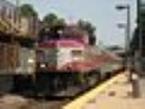
The Fitchburg Line is an MBTA line that runs from Boston's North Station to Fitchburg, Massachusetts
. The line is along the tracks of the former Fitchburg Railroad
, which was a railroad line across northern Massachusetts
, United States
, leading to and through the Hoosac Tunnel
. It is one of the more scenic commuter rail lines, passing by Walden Pond
between Lincoln
and Concord
. The Fitchburg Line is the longest line in the system in terms of both length and travel time, and ranks as one of the worst lines in terms of on time performance. The MBTA attributes this to the facts that the line has the oldest and least adequate infrastructure in the system and commuter trains must compete with freight traffic, mainly between South Acton and Ayer. Despite this, the Fitchburg Line still draws about 10,000 daily riders, and the MBTA expects it to draw even more once upgrades to the line are completed.
opened between 1840 and 1845 from Boston to Fitchburg. The Boston and Maine Railroad
leased the Fitchburg Railroad in 1900 and bought it finally in 1919. The portion between Fitchburg and Boston was sold to the MBTA on December 27, 1976 as part of Boston & Maine's divestiture of commuter rail operations.
Passenger service ran only to Fitchburg after 1960, after the Boston and Maine eliminated its through service to its western terminal in Troy, NY. In the early 1960s at least part of the right-of-way was to be utilized to connect Route 2 with the proposed Interstate 695
(Inner Belt) in Union Square, Somerville. On January 18, 1965 service was cut back to West Concord, but was restored to Ayer on June 28, 1965. On March 1, 1975 it was cut back to South Acton, but was restored to Fitchburg and beyond to Gardner on January 13, 1980. Gardner service was ended on January 1, 1987 when Amtrak
took over the MBTA contract, due to a dispute between Amtrak and Guilford; the MBTA only owned the trackage to Fitchburg. The Fitchburg route was once double tracked from Boston to Troy, NY. Double tracks now extend only to Acton, MA which is why, operationally, South Acton is the only station beyond Cambridge at which every train stops. Since the advent of Commuter Rail Operations by the Commonwealth, several stations along the Fitchburg lines have been closed. These include Clematis Brook and Beaver Brook in Waltham, West Acton in Acton and Harwood Depot on Taylor Street in Littleton, the last of which was immediately replaced by Littleton/495 station a mile away.
The Fitchburg Line west of the old Stony Brook Railroad
, which now junctions east of the old Ayer Junction, now serves as part of Guilford's main line between Mattawamkeag, Maine
and Mechanicville, New York
.
The Walden Street Cattle Pass
crosses beneath the Walden Street bridge in Cambridge, adjacent to the tracks; it was last used in the 1920s.
.
Fitchburg, Massachusetts
Fitchburg is the third largest city in Worcester County, Massachusetts, United States. The population was 40,318 at the 2010 census. Fitchburg is home to Fitchburg State University as well as 17 public and private elementary and high schools.- History :...
. The line is along the tracks of the former Fitchburg Railroad
Fitchburg Railroad
The Fitchburg Railroad is a former railroad company, which built a railroad line across northern Massachusetts, USA, leading to and through the Hoosac Tunnel. The Fitchburg was leased to the Boston and Maine Railroad in 1900...
, which was a railroad line across northern Massachusetts
Massachusetts
The Commonwealth of Massachusetts is a state in the New England region of the northeastern United States of America. It is bordered by Rhode Island and Connecticut to the south, New York to the west, and Vermont and New Hampshire to the north; at its east lies the Atlantic Ocean. As of the 2010...
, United States
United States
The United States of America is a federal constitutional republic comprising fifty states and a federal district...
, leading to and through the Hoosac Tunnel
Hoosac Tunnel
The Hoosac Tunnel is a 4.75-mile-long railroad tunnel in western Massachusetts which passes through the Hoosac Range, an extension of Vermont's Green Mountains. Work began in 1848 and was finally completed in 1875...
. It is one of the more scenic commuter rail lines, passing by Walden Pond
Walden Pond
Walden Pond is a 31-metre-deep lake in Massachusetts . It is in area and around, located in Concord, Massachusetts, in the United States...
between Lincoln
Lincoln (MBTA station)
Lincoln is a passenger rail station on MBTA Commuter Rail's Fitchburg Line. It has an unusual layout that can be confusing to anyone who is not familiar with it. There are 2 tracks and 2 side platforms which are both alongside the outbound track. The two platforms are separated by Lincoln Rd....
and Concord
Concord (MBTA station)
Concord Depot is a rail station on the MBTA Commuter Rail system in Concord, Massachusetts. The station is located at 90 Thoreau Street in Concord Center. Service to the station is provided by the Fitchburg Line from Boston to Fitchburg, Massachusetts both inbound and outbound. The depot building...
. The Fitchburg Line is the longest line in the system in terms of both length and travel time, and ranks as one of the worst lines in terms of on time performance. The MBTA attributes this to the facts that the line has the oldest and least adequate infrastructure in the system and commuter trains must compete with freight traffic, mainly between South Acton and Ayer. Despite this, the Fitchburg Line still draws about 10,000 daily riders, and the MBTA expects it to draw even more once upgrades to the line are completed.
History
The Fitchburg RailroadFitchburg Railroad
The Fitchburg Railroad is a former railroad company, which built a railroad line across northern Massachusetts, USA, leading to and through the Hoosac Tunnel. The Fitchburg was leased to the Boston and Maine Railroad in 1900...
opened between 1840 and 1845 from Boston to Fitchburg. The Boston and Maine Railroad
Boston and Maine Railroad
The Boston and Maine Corporation , known as the Boston and Maine Railroad until 1964, was the dominant railroad of the northern New England region of the United States for a century...
leased the Fitchburg Railroad in 1900 and bought it finally in 1919. The portion between Fitchburg and Boston was sold to the MBTA on December 27, 1976 as part of Boston & Maine's divestiture of commuter rail operations.
Passenger service ran only to Fitchburg after 1960, after the Boston and Maine eliminated its through service to its western terminal in Troy, NY. In the early 1960s at least part of the right-of-way was to be utilized to connect Route 2 with the proposed Interstate 695
Interstate 695 (Massachusetts)
The Inner Belt in Boston was a planned six-lane, limited-access highway that would have run through parts of Boston, Brookline, Cambridge, and Somerville.-History:...
(Inner Belt) in Union Square, Somerville. On January 18, 1965 service was cut back to West Concord, but was restored to Ayer on June 28, 1965. On March 1, 1975 it was cut back to South Acton, but was restored to Fitchburg and beyond to Gardner on January 13, 1980. Gardner service was ended on January 1, 1987 when Amtrak
Amtrak
The National Railroad Passenger Corporation, doing business as Amtrak , is a government-owned corporation that was organized on May 1, 1971, to provide intercity passenger train service in the United States. "Amtrak" is a portmanteau of the words "America" and "track". It is headquartered at Union...
took over the MBTA contract, due to a dispute between Amtrak and Guilford; the MBTA only owned the trackage to Fitchburg. The Fitchburg route was once double tracked from Boston to Troy, NY. Double tracks now extend only to Acton, MA which is why, operationally, South Acton is the only station beyond Cambridge at which every train stops. Since the advent of Commuter Rail Operations by the Commonwealth, several stations along the Fitchburg lines have been closed. These include Clematis Brook and Beaver Brook in Waltham, West Acton in Acton and Harwood Depot on Taylor Street in Littleton, the last of which was immediately replaced by Littleton/495 station a mile away.
The Fitchburg Line west of the old Stony Brook Railroad
Stony Brook Railroad
The Stony Brook Railroad was a short line railroad that ran off the Nashua and Lowell Railroad's main line from the village of North Chelmsford to Ayer where it connected to the Fitchburg Railroad.-History:...
, which now junctions east of the old Ayer Junction, now serves as part of Guilford's main line between Mattawamkeag, Maine
Mattawamkeag, Maine
Mattawamkeag is a town in Penobscot County, Maine, United States located where the Mattawamkeag River joins the Penobscot River. The population was 825 at the 2000 census.-Railroad history:Mattawamkeag's history is inextricably linked to the railroad....
and Mechanicville, New York
Mechanicville, New York
Mechanicville is a city in Saratoga County, New York, United States. The population is 5,196 as of the 2010 census. It is the smallest city by area in the state. The name is derived from the occupations of early residents....
.
The Walden Street Cattle Pass
Walden Street Cattle Pass
Walden Street Cattle Pass, also referred to as the cow path, is an historic site adjacent to the MBTA Commuter Rail Fitchburg Line right-of-way, under the Walden Street Bridge in Cambridge, Massachusetts. It was added to the National Historic Register in 1994.The site, a tunnel for moving cattle...
crosses beneath the Walden Street bridge in Cambridge, adjacent to the tracks; it was last used in the 1920s.
Planned improvements
On February 17, 2009, the US Department of Transportation awarded $55.5 million towards the extension of the line from Fitchburg to a new terminus to be called Wachusett. The station is scheduled to start service in 2012. There is a plan to upgrade the Fitchburg Line to have cab signaling. In conjunction with this $70m upgrade, plans include track rehabilitation to increase speed and the extension of double track from South Acton to Ayer to allow an increase in capacity.Accessibility
Only six of the stations, including both terminals, are wheelchair accessible. See also MBTA accessibilityMBTA accessibility
Physical accessibility on the Massachusetts Bay Transportation Authority system is incomplete but improving, with accessibility on all buses , all Orange Line stations, all but 2 Red Line stations, and all but 2 Blue Line stations...
.
Station and junction listing
| Milepost | City | Station / Junction | Opening date | Connections and notes |
|---|---|---|---|---|
| 0.0 | Boston | North Station | Orange Line Orange Line (MBTA) The Orange Line is one of the four subway lines of the Massachusetts Bay Transportation Authority. It extends from Forest Hills in Jamaica Plain, Boston in the south to Oak Grove in Malden, Massachusetts in the north. It meets the Red Line at Downtown Crossing, the Blue Line at State, and the Green... , Green Line Green Line (MBTA) The Green Line is a streetcar system run by the Massachusetts Bay Transportation Authority in the Boston, Massachusetts area of the United States. It is the oldest line of Boston's subway, which is known locally as the 'T'. The Green Line runs underground downtown and on the surface in outlying... and all north side Commuter Rail MBTA Commuter Rail The MBTA Commuter Rail serves as the regional rail arm of the Massachusetts Bay Transportation Authority, in the United States. It is operated under contract by the Massachusetts Bay Commuter Railroad Company a joint partnership of Veolia Transportation, Bombardier Transportation and Alternate... lines Amtrak Amtrak The National Railroad Passenger Corporation, doing business as Amtrak , is a government-owned corporation that was organized on May 1, 1971, to provide intercity passenger train service in the United States. "Amtrak" is a portmanteau of the words "America" and "track". It is headquartered at Union... Downeaster Downeaster The Downeaster is a 116-mile regional passenger train service managed by the Northern New England Passenger Rail Authority and operated by Amtrak, connecting North Station in Boston, Massachusetts, to Portland, Maine... |
|
| Boston Engine Terminal | A flag stop with a wooden platform for MBTA employees only | |||
| MBTA Commuter Rail MBTA Commuter Rail The MBTA Commuter Rail serves as the regional rail arm of the Massachusetts Bay Transportation Authority, in the United States. It is operated under contract by the Massachusetts Bay Commuter Railroad Company a joint partnership of Veolia Transportation, Bombardier Transportation and Alternate... Lowell Line Lowell Line The Lowell Line is a railroad line of the MBTA Commuter Rail system, running north from Boston to Lowell, Massachusetts. Originally built as the Boston and Lowell Railroad, and later operated as part of the Boston and Maine Railroad's Southern Division, the line was one of the first railroads in... , Haverhill/Reading Line Haverhill/Reading Line The Haverhill Line is a branch of the MBTA Commuter Rail system, running north from downtown Boston, Massachusetts through the cities and towns ofMalden,Melrose,Wakefield,Reading,Wilmington,Andover,... and Newburyport/Rockport Line Newburyport/Rockport Line The Newburyport/Rockport Line is a branch of the MBTA Commuter Rail system, running northeast from downtown Boston, Massachusetts towards Cape Ann and the Merrimack Valley, serving the North Shore. The first leg serves Chelsea, Lynn, Swampscott, Salem, and Beverly. From there, a northern branch of... split |
||||
| Somerville Somerville, Massachusetts Somerville is a city in Middlesex County, Massachusetts, United States, located just north of Boston. As of the 2010 census, the city had a total population of 75,754 and was the most densely populated municipality in New England. It is also the 17th most densely populated incorporated place in... |
Union Square | 1835 | closed | |
| Somerville | closed (Park Street) | |||
| 3.37 | Cambridge Cambridge, Massachusetts Cambridge is a city in Middlesex County, Massachusetts, United States, in the Greater Boston area. It was named in honor of the University of Cambridge in England, an important center of the Puritan theology embraced by the town's founders. Cambridge is home to two of the world's most prominent... |
Porter Square Porter (MBTA station) Porter is a train station in Cambridge, Massachusetts. It is located at the intersection of Massachusetts Avenue and Somerville Avenue . It also serves portions of Somerville. The station was designed by Cambridge Seven Associates and opened on December 8, 1984. At 105 feet below ground, it is the... |
Red Line Red Line (MBTA) The Red Line is a rapid transit line operated by the MBTA running roughly north-south through Boston, Massachusetts into neighboring communities. The line begins west of Boston, in Cambridge, Massachusetts at Alewife station, near the intersection of Alewife Brook Parkway and Route 2... , originally Porter's |
|
| 4.16 | West Cambridge (station) | closed (137 Sherman Street) | ||
| 4.29 | West Cambridge (junction) | split with (abandoned) Watertown Branch Railroad Watertown Branch Railroad The Watertown Branch Railroad was a branch loop of the Fitchburg Railroad that was meant to serve the town of Watertown, and the City of Waltham, Middlesex County, Massachusetts as an independent short line railroad. It also serviced the Watertown Arsenal. The line is no longer in use and portions... loop (near New Street) |
||
| 4.53 | Brick Yards (Fens) | closed; split with (abandoned) Lexington and West Cambridge Railroad Lexington and West Cambridge Railroad The Lexington and West Cambridge Railroad was a railroad company chartered in 1845 and opened in 1846, that operated in eastern Massachusetts. It and its successors provided passenger service until 1977 and freight service until 1980 or early 1981.... (just east of Alewife Brook Parkway) |
||
| 5.35 | join with (abandoned) Fitchburg Cutoff | |||
| 5.52 | Belmont Belmont, Massachusetts Belmont is a town in Middlesex County, Massachusetts, a suburb of Boston. The population was 24,729 at the 2010 census.- History :Belmont was founded on March 18, 1859 by former citizens of, and land from the bordering towns of Watertown, to the south; Waltham, to the west; and Arlington, then... |
Hill Crossing | closed (near Brighton Street, Belmont/Blanchard Road, Cambridge) | |
| 6.43 | Belmont Center Belmont Center (MBTA station) Belmont Center Station is a rail station on the MBTA Commuter Rail system in Belmont, Massachusetts.The station stop is located at the intersection of Common Street and Concord Avenue in Belmont Center... |
74/75 bus, temporarily closed 1958, reopened March 4, 1974 | ||
| 7.39 | Waverley Waverley (MBTA station) Waverley is a passenger rail station on the MBTA Commuter Rail Fitchburg Line, in Waverley Square, Belmont, Massachusetts. The station is located below grade, in the triangle of Trapelo Road, Lexington Street, and Church Street in western Belmont. This location is also the western terminus of the... |
73 trackless trolley, temporarily closed 1958, reopened March 4, 1974. | ||
| 8.31 | Waltham Waltham, Massachusetts Waltham is a city in Middlesex County, Massachusetts, United States, was an early center for the labor movement, and major contributor to the American Industrial Revolution. The original home of the Boston Manufacturing Company, the city was a prototype for 19th century industrial city planning,... |
Clematis Brook | closed June 1978. Was located off Clematis Ave. in Waltham. Track connection to the (abandoned) Central Massachusetts Railroad Central Massachusetts Railroad The Central Massachusetts Railroad was a railroad running west from Boston, Massachusetts, USA, as a parallel competitor to the Boston and Albany Railroad and Fitchburg Railroad... . |
|
| 9.26 | Beaver Brook | closed June 1978. Was located on Rose Hill Way in Waltham. | ||
| join with (abandoned) Watertown Branch Railroad Watertown Branch Railroad The Watertown Branch Railroad was a branch loop of the Fitchburg Railroad that was meant to serve the town of Watertown, and the City of Waltham, Middlesex County, Massachusetts as an independent short line railroad. It also serviced the Watertown Arsenal. The line is no longer in use and portions... loop |
||||
| 9.86 | Waltham Waltham (MBTA station) Waltham is a passenger rail station on MBTA Commuter Rail's Fitchburg Line.It is located in downtown Waltham and is a short walk from manyrestaurants, shops and bars along Moody Street and Main Street, as well as the Embassy movie theater.-Bus connections:... |
70, 70A, 505, 553, 554, 556, 558 buses | ||
| 10.55 | Riverview | closed January 17, 1965 | ||
| 11.49 | Brandeis/Roberts Brandeis/Roberts (MBTA station) Brandeis/Roberts is a passenger rail station on MBTA Commuter Rail's Fitchburg Line.It is located on the edge of the campus of Brandeis University in Waltham, Massachusetts.-External links:* * *... |
originally Roberts | ||
| 12.23 | Weston Weston, Massachusetts Weston is a suburb of Boston located in Middlesex County, Massachusetts, United States in the Boston metro area. The population of Weston, according to the 2010 U.S. Census, is 11,261.... |
Stony Brook Stony Brook (B&M station) Stony Brook was a Boston and Maine Railroad station in Weston, Massachusetts, built along what is currently the Massachusetts Bay Transportation Authority Fitchburg Line. This station was removed due to the construction of Massachusetts Route 128.... |
closed | |
| 13.16 | Kendal Green Kendal Green (MBTA station) Kendal Green is a passenger rail station on MBTA Commuter Rail's Fitchburg Line in Weston, Massachusetts. It has 2 tracks with 1 platform on the outbound side. Inbound passengers board via an asphalt patch that crosses the outbound tracks from the platform... |
|||
| 13.72 | Hastings Hastings (MBTA station) Hastings is a passenger rail station on MBTA Commuter Rail's Fitchburg Line, 13.72 miles from North Station in downtown Boston. Service is limited, with only five inbound trains and six outbound trains on weekdays, and no weekend trains.... |
limited service, five inbound trains and six outbound trains on weekdays. | ||
| 14.71 | Silver Hill Silver Hill (MBTA station) Silver Hill Station is a small train station located off Merriam Street in Weston, Massachusetts. It is on the Fitchburg Line of the MBTA Commuter Rail, from North Station in Boston. Silver Hill has very limited service, with two inbound trains and three outbound trains on weekdays only... |
limited service, two inbound trains and three outbound trains on weekdays. | ||
| 16.66 | Lincoln Lincoln, Massachusetts Lincoln is a town in the historic area of Middlesex County, Massachusetts, United States. The population was 6,362 at the 2010 census, including residents of Hanscom Air Force Base that live within town limits... |
Lincoln Lincoln (MBTA station) Lincoln is a passenger rail station on MBTA Commuter Rail's Fitchburg Line. It has an unusual layout that can be confusing to anyone who is not familiar with it. There are 2 tracks and 2 side platforms which are both alongside the outbound track. The two platforms are separated by Lincoln Rd.... |
originally South Lincoln | |
| 17.76 | Baker Bridge | closed | ||
| 20.05 | Concord Concord, Massachusetts Concord is a town in Middlesex County, Massachusetts, in the United States. As of the 2010 census, the town population was 17,668. Although a small town, Concord is noted for its leading roles in American history and literature.-History:... |
Concord Concord (MBTA station) Concord Depot is a rail station on the MBTA Commuter Rail system in Concord, Massachusetts. The station is located at 90 Thoreau Street in Concord Center. Service to the station is provided by the Fitchburg Line from Boston to Fitchburg, Massachusetts both inbound and outbound. The depot building... |
||
| 21.89 | West Concord West Concord Depot West Concord Depot is a rail station on the MBTA Commuter Rail system in West Concord, Massachusetts. The depot, which opened in 1894, is listed on the U.S. National Register of Historic Places.-Location:... |
|||
| 25.06 | Acton Acton, Massachusetts Acton is a suburban town in Middlesex County, Massachusetts, United States about twenty-one miles west-northwest of Boston along Route 2 west of Concord and about ten miles southwest of Lowell. The population was 21,924 at the 2010 census... |
South Acton South Acton (MBTA station) South Acton is a station on the MBTA Fitchburg Line in Acton, Massachusetts. The station is owned by the Town of Acton and is located at 10 Central Street near Massachusetts Route 27. It is the busiest station on the Fitchburg line, accounting for roughly 873 weekday passenger boardings,... |
Clock Tower Shuttle; terminal station for some trains; temporarily closed January 17, 1965, reopened June 28, 1965. The original South Acton station was located on School Street east of the Main Street bridge. The station building burned in the early 1970s. The station was relocated west of Main Street Bridge with an entrance of off Central Street. South Acton contains the largest number of parking spots on the line. | |
| 26.77 | West Acton | closed January 17, 1965, reopened June 28, 1965, closed April 30, 1975. The station building has been torn down and currently houses New London Pizza. | ||
| 28.93 | Boxborough Boxborough, Massachusetts Boxborough is a town in Middlesex County, Massachusetts, United States. The population was 4,996 at the 2010 census. The town name is often spelled "Boxboro" on highway signs and official documents, but the correct spelling is, in fact, Boxborough.... |
Boxboro | closed. The station stop was located on Depot Road. | |
| 30.16 | Littleton Littleton, Massachusetts Littleton is a town in Middlesex County, Massachusetts, United States. The population was 8,924 at the 2010 census.... |
Littleton/Route 495 Littleton/Route 495 (MBTA station) Littleton/Route 495 is a rail station on the MBTA Commuter Rail system in Littleton, Massachusetts. The station is located at the intersection of Grimes Lane and Foster Street... |
1980 | opened January 13, 1980, as a replacement for the former Littleton station. It is located near the intersection of Route 2 and Interstate 495 Interstate 495 (Massachusetts) Interstate 495 is the designation of an Interstate Highway half-beltway in Massachusetts. It was the longest auxiliary Interstate Highway of its kind—measuring 120.74 miles —until 1996, when the PA Route 9 section of the Pennsylvania Turnpike was redesignated as Interstate 476, making it about ... , on Foster St. |
| 31.47 | Littleton | Opened 1879, temporarily closed January 17, 1965, reopened June 28, 1965, closed April 30, 1975. Replaced by Littleton/Route 495. The former station still stands at the intersection of Taylor Road and King Street. | ||
| 33.72 | Ayer Ayer, Massachusetts Ayer is a town in Middlesex County, Massachusetts, United States. Originally part of Groton, it was incorporated February 14, 1871 and became a major commercial railroad junction. The town was home to Camp Stevens, a training camp for Massachusetts volunteers during the American Civil War... |
Willows | closed; also known as Harwood. It was located between Littleton and Ayer and served both communities. | |
| 36.07 316.07 |
Ayer Ayer (MBTA station) Ayer MBTA Station is a rail station on the MBTA Commuter Rail system in Ayer, Massachusetts. The station is located at 70 Main Street in the Ayer Main Street Historic District. Service to the station is provided by the Fitchburg Line from Boston to Fitchburg, Massachusetts both inbound and outbound... |
temporarily closed January 17, 1965, reopened June 28, 1965, temporarily closed April 30, 1975, reopened January 13, 1980 | ||
| 39.43 319.43 |
Shirley Shirley, Massachusetts -Demographics:This article describes the town of Shirley as a whole. Additional demographic detail is available which describes only the central settlement or village within the town, although that detail is included in the aggregate values reported here... |
Shirley Shirley (MBTA station) Shirley is a passenger rail station on MBTA Commuter Rail's Fitchburg Line. The station is located at Ayer Road and Phoenix Street in Shirley, Massachusetts. There is a small parking area adjacent to the street. There is one small platform that is only about 10 feet long on the inbound side with an... |
temporarily closed January 17, 1965, reopened May 1981 | |
| 42.14 322.14 |
Lunenburg Lunenburg, Massachusetts Lunenburg is a town in Worcester County, Massachusetts, United States. The population was 10,086 at the 2010 census.For geographic and demographic information on the census-designated place Lunenburg, please see the article Lunenburg , Massachusetts.... |
Lunenburg | closed | |
| 45.34 325.34 |
Leominster Leominster, Massachusetts Leominster is a city in Worcester County, Massachusetts, United States. It is the second-largest city in Worcester County, with a population of 40,759 at the 2010 census. Leominster is located north of Worcester and west of Boston. Both Route 2 and Route 12 pass through Leominster. Interstate 190,... |
North Leominster North Leominster (MBTA station) North Leominster is the penultimate railroad station on MBTA Commuter Rail's Fitchburg Line. The station is located at 34 Nashua Street east of Main Street in Leominster, Massachusetts. The station is handicap accessible and has plenty of parking for vehicles and bicycles. There are connections to... |
temporarily closed January 17, 1965, reopened January 13, 1980 | |
| 49.55 329.55 |
Fitchburg Fitchburg, Massachusetts Fitchburg is the third largest city in Worcester County, Massachusetts, United States. The population was 40,318 at the 2010 census. Fitchburg is home to Fitchburg State University as well as 17 public and private elementary and high schools.- History :... |
Fitchburg Fitchburg (MBTA station) Fitchburg is a passenger rail station on MBTA Commuter Rail's Fitchburg Line, located at 100 Main St., Fitchburg, Massachusetts, and is the northern terminus for Fitchburg Line trains... |
MRTA Buses Montachusett Regional Transit Authority The Montachusett Regional Transit Authority is one of Massachusetts' regional transit authorities. It is a public, non-profit organization in Massachusetts, charged with providing public transportation to an area consisting of the cities of Fitchburg, Leominster and Gardner, and the adjoining... to Gardner, temporarily closed January 17, 1965, reopened January 13, 1980 |
|
| Wachusett Wachusett (MBTA station) Wachusett is a planned passenger rail station on MBTA Commuter Rail's Fitchburg Line, to be located northwest of the intersection of Massachusetts Route 2 and Route 31... |
Planned for opening in 2012 based on construction begun in 2010 | |||
| South Ashburnham South Ashburnham, Massachusetts South Ashburnham is a census-designated place in the town of Ashburnham in Worcester County, Massachusetts, United States. The population was 1,062 at the 2010 census.-Geography:South Ashburnham is located at .... |
South Ashburnham | closed | ||
| Gardner Gardner, Massachusetts Gardner, Massachusetts is a city in Worcester County, Massachusetts, United States. The population was 20,228 as of the 2010 census. Gardner is home to Dunn State Park, Gardner Heritage State Park, Lake Wampanoag Wildlife Sanctuary, and Mount Wachusett Community College.-History:Named in honor of... |
Gardner | opened January 13, 1980, closed January 1, 1987 |