
Bend Arch-Fort Worth Basin
Encyclopedia
The Bend Arch–Fort Worth Basin Province is a major petroleum
producing geological system which is primarily located in north central Texas
and southwestern Oklahoma
. It is officially designated by the United States Geological Survey
(USGS) as Province 045 and classified as the Barnett-Paleozoic Total Petroleum System (TPS).
and gas
in Province 045 are produced from carbonate
and clastic rock reservoirs ranging in age from the Ordovician
to the Permian
. The 1995 USGS Assessment of undiscovered, technically recoverable oil and gas identified six conventional plays in Province 045, which are listed below in Table 1: One continuous unconventional play, hypothetical "Mississippian Barnett Shale
" (4503), was also considered. The cumulative mean of undiscovered resource for conventional plays was: 381 Moilbbl of oil, 103.6 Moilbbl of natural gas liquids, 479 Gcuft associated gas, and 1029 Gcuft non-associated gas.
Notes:
1.Assessment unit number also indicates time span of stratigraphic units.
The USGS assessment of undiscovered conventional oil and gas and undiscovered continuous (unconventional) gas within Province 045 resulted in estimated means of 26.7 Tcuft (Tcf) of undiscovered natural gas, 98.5 Moilbbl of undiscovered oil, and a mean of 1.1 Goilbbl of undiscovered natural gas liquids. Nearly all of the undiscovered gas resource (98%, or is considered to be in continuous accumulations of nonassociated gas trapped in strata of two of the three Mississippian-age Barnett Shale Assessment Units (AUs) - the Greater Newark East Frac-Barrier Continuous Barnett Shale Gas AU and the Extended Continuous Barnett Shale Gas AU combined). The remaining 467 Gcuft of undiscovered gas resource in the Province is in conventional nonassociated gas accumulations or and associated/dissolved gas in conventional oil accumulations ( or . The Barnett-Paleozoic TPS is estimated to contain a mean of 409.2 Gcuft of conventional gas, or about 88% of all undiscovered conventional gas, and about 64.6 Moilbbl of conventional oil, or about 65% of all undiscovered oil in Province 045.
Continuous-type accumulations include fractured shale and fractured chalk
oil and gas, basin-centered gas, coal bed gas, and tight reservoir gas. They typically cover large areas, have source rocks in close association with these unconventional reservoir rocks, and are mostly gas (and in some cases oil) charged throughout their extent. Continuous accumulations commonly have transition zones that grade into more conventional accumulations.
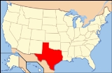
 The Fort Worth Basin and Bend Arch lie entirely within north central Texas
covering an area of 54000 square miles (139,859.4 km²). The southern and eastern boundaries are defined by county lines that generally follow the Ouachita
structural front, although a substantial portion of this structural feature is included near Dallas. The north boundary follows the Texas-Oklahoma State line in the east, where the province includes parts of the Sherman Basin and Muenster Arch. In the west, the north boundary follows the north-east county lines of Oklahoma's three southwestern counties (Harmon, Jackson and Tillman Counties), which include the south flank of the Wichita Mountains
and the Hollis Basin. The western boundary trends north-south along county lines defining the junction with the Permian Basin where part of the eastern shelf of the Permian Basin lies in Province 045.
and Red River
Arches to the north, and the Bend and Lampasas Arches along the central part of Province 045. Along the east portion is an area that includes the Eastern Shelf and Concho Arch, collectively known as the Concho Platform. The Mineral Wells fault runs northeast-southwest through Palo Pinto, Parker, Wise, Denton Counties and joins with the Newark East fault system. The fault system bisects the Newark East Field (NE-F) creating a zone of poor production in Barnett Shale gas reservoirs. Several faults that cut basement and lower Paleozoic rocks in the southern part of the province are identified at the Ordovican Ellenburger Group stratigraphic level. These faults and associated structures formed during development of the Llano Uplift
and Fort Worth Basin with faulting ending by the early Missourian.
foreland
basin with about 12000 feet (3,657.6 m) of strata
preserved in its deepest northeast portion and adjacent to the Muenster Arch and Ouachita structural belt. The basin resembles other basins of the Ouachita structural belt, such as the Black Warrior, Arkoma, Val Verde
, and Marfa Basins that formed in front of the advancing Ouachita structural belt as it was thrust onto the margin of North America
. Thrusting occurred during a late Paleozoic
episode of plate
convergence.
and diorite
. Cambrian rocks include granite conglomerate, sandstones, and shale that are overlain by marine carbonate rocks and shale. No production has been reported from Cambrian rocks. The Silurian
, Devonian
, Jurassic
, and Triassic
are absent in the Fort Worth Basin.
From Cambrian to Mississippian time, the Fort Worth Basin area was part of a stable cratonic shelf with deposition dominated by carbonates. Ellenburger Group carbonate rocks represent a broad epeiric carbonate platform covering most of Texas during the Early Ordovician
. A pronounced drop in sea level
sometime between Late Ordovician and Mississippian time resulted in prolonged platform exposure. This erosional event removed any Silurian
and Devonian rocks (post Viola Limestone unconformity) that may have been present. Barnett Shale was deposited over the resulting unconformity. Provenance of the terrigenous material that constitutes the Barnett Shale was from Ouchita thrust sheets and the reactivation of older structures such as the Muenster Arch. Post-Barnett deposition continued without interruption as a sequenced of extremely hard and dense limestones were laid down. These limestones have often been confused with the lower part of the overlying Marble Falls Formation, and they have never been formally named in the literature. Since the underlying Barnett is generally assumed to be Late Mississippian Chester in age, the superposed carbonates are often referred to informally as "the Chester Limestones."
Clastic rocks of provenance similar to the Barnett dominate the Pennsylvanian part of the stratigraphic section in the Bend Arch-Fort Worth Basin. With progressive subsidence of the basin during the Pennsylvanian, the western basin hinge line and carbonate shelf, continued migrating west. Deposition of thick basinal clastic rocks of the Atoka, Strawn, and Canyon Formations occurred at this time. These Mid- and Late Pennsylvanian rocks consist mostly of sandstones and conglomerates with fewer and thinner limestone
beds.
shows were first encountered in Province 045 during the mid-nineteenth century while drilling water wells. Sporadic exploration began following the War for Southern Independence, and the first commercial oil discoveries occurred in the early 1900s. In 1917, discovery of Ranger field stimulated one of the largest exploration and development "booms" in Texas. Ranger field produces from the Atoka-Bend formation, a sandstone-conglomerate reservoir that directly overlies the Barnett formation. Operators drilled more than 1,000 wildcats in and around the Fort Worth basin attempting to duplicate the success of Ranger. These wildcat
efforts resulted in the discovery of more fields and production from numerous other reservoirs including Strawn fluvial/deltaic sandstone, Atoka-Bend fluvial/deltaic sandstone and conglomerate, Marble Falls carbonate bank limestone, Barnett siliceous shale, and Ellenburger dolomitic limestone. By 1960, the Province reached a mature stage of exploration and development, as demonstrated by the high density and distribution of well penetrations and production wells. Oil and lesser amounts of gas are found throughout the Paleozoic section, but most hydrocarbons consist of oil in Pennsylvanian reservoirs.
Province 045 is among the more active drilling areas during the resurgence of U.S. drilling, which began after the OPEC
oil embargo
. It has consistently appeared on the list of the 10 most active provinces in terms of wells completed and footage drilled. 9,177 oil wells and 4,520 gas wells were drilled and completed in this area from 1974 to 1980.
Cumulative production in Province 045 from conventional reservoirs prior to the 1995 USGS Assessment was 2 Goilbbl of oil, 7.8 Tcuft of gas, and 500 Moilbbl of natural gas liquids. Cumulative gas production through 2001 from the continuous Barnett fractured shale play in Wise and Denton counties was about 440 Gcuft. Cumulative gas production from the Barnett Shale for the first half of 2002 was 94 Gcuft; annual production for 2002 was estimated at 200 Gcuft. Currently, over 2.5 Tcuft of proven gas reserves are assessed for NE-F. These production and proven reserve figures for the Barnett play, combined with estimates of underdeveloped Barnett resources indicate that technically recoverable continuous gas, and to a lesser extent oil, from fractured Barnett Shale will provide the greatest additions to near-future reserves in Province 045.
of the Bend Arch–Fort Worth Basin is Mississippian Chester-age Barnett Shale. The Barnett commonly exhibits high gamma-ray log response at the base of the unit. Other potential source rocks of secondary importance are Early Pennsylvanian and include dark fine-grained carbonate rock and shale units within the Marble Falls Limestone and the black shale facies of the Smithwick/Atoka Shale. The Barnett Shale was deposited over much of North-Central Texas; however, because of post-depositional erosion
, the present distribution of Barnett is limited to Province 045. The Barnett Shale is over 1000 feet (304.8 m) thick along the southwest flank of the Muenster Arch. It is eroded in areas along the Red River-Electra and Muenster Arches to the north, the Llano uplift to the south where it outcrops, and the easternmost portion of the province where the Barnett laps onto the Eastern Shelf-Concho Platform.
Average total organic carbon
(TOC) content in the Barnett Shale is about 4% and TOC is as high as 12% in samples from outcrops along the Llano uplift on the south flank of the Fort Worth Basin. It has geochemical characteristics similar to other Devonian-Mississippian black shales found elsewhere in the US (e.g., Woodford, Bakken
, New Albany, and Chattanooga Formations). These black shales all contain oil-prone organic matter (Type II kerogen
) based on hydrogen indices above 350 milligrams of hydrocarbons per gram of TOC and generate a similar type of high quality oil (low sulfur
, >30 API gravity). Although kerogen
cracking decomposition is a source of oil and gas from the Barnett Shale, the principal source of gas in the Newark East Field is from cracking of oil and bitumen.
reflectance (Ro), estimated at 0.6-0.7%, yield oils of 38° API gravity
in Brown County
. Oils found in Shackelford, Throckmorton, and Callahan Counties as well, as in Montague County, are derived from Barnett Shale at the middle of the zone of oil generation (oil window) thermal maturities levels (≈0.9% Ro). Although condensate
is associated with gas production in Wise County
, Barnett source rock maturity is generally 1.1% Ro or greater. The zone of wet gas
generation is in the 1.1-1.4% Ro range, whereas the primary zone of dry gas
generation (main gas window) begins at a Ro of 1.4%.
Thermal
maturity of Barnett Shale can also be derived from TOC and Rock-Eval (Tmax) measurements. Although Tmax is not very reliable for high maturity kerogens due to poor pyrolysis
peak yields and peak shape, the extent of kerogen transformation can be utilized. For example, Barnett Shale having a 4.5% TOC and a hydrogen
index of less than 100 is in the wet or dry gas windows with equivalent Ro values greater than 1.1% TOC. In contrast, low maturity Barnett Shale from Lampasas County outcrops have initial TOC values averaging about 12% with hydrocarbon potentials averaging 9.85 % by volume. A good average value for Barnett Shale is derived from the Mitcham #1 well in Brown County
where TOC is 4.2% and hydrocarbon potential is 3.37% by volume. Using these data we can determine TOC values will decrease 36% during maturation from the immature stage to the gas-generation window. Samples from the T. P. Simms well in the Newark East gas-producing area have average TOC values of 4.5%, but greater than 90% of the organic matter is converted to hydrocarbons. Thus, its original TOC was about 7.0% with an initial estimated potential of 5.64% by volume. Any oil generated would be expelled into shallow (or deeper) horizons as in the west and north, or cracked to gas where measured vitrinite reflectance is above 1.1% Ro.
(GCMS) analyses. The API gravity of the oils ranges from 35° to 62° and sulfur contents are low (<0.2%), which is characteristic of high thermal maturity oils. Biomarkers from GCMS analyses show oils were sourced from marine shale, based on sterane distribution and the presence of diasteranes. Carbon isotopic
analyses of saturated and aromatic hydrocarbon fractions support hydrocarbon generation from a single-source unit. In the main gas-producing area of fractured Barnett Shale, the gas generation window is along a trend sub-parallel to the Ouchita thrust front. Jarvie (2001) reported the British Thermal Unit
(BTU) content of Barnett gas is directly proportional to Ro levels.
units and dense, low permeability carbonate rock that are distributed on both regional and local scales. Barnett Shale is a major regional seal for older reservoirs, mostly porous carbonate rock reservoirs of the Ellenburger Group. Production from Barnett Shale is largely dependent on the presence or absence of Marble Falls and Viola limestones. Although these formations are not considered seal rocks in areas where they are tight and not water wet, they serve as barriers confining hydraulic-induced fracturing (frac barriers) and help retain formation pressures during well stimulation.
reservoirs. Stratigraphic traps in carbonate rocks result from a combination of facies
and depositional topography
, erosion, updip pinchout of facies, and diagenetically controlled enhanced-permeability and porosity zones. A good example of a carbonate stratigraphic trap is the pinnacle reef traps of the Chappel Limestone, where local porous grainstone
and packstone are restricted to isolated buildups or reef
clusters on low-relief paleotopography of the eroded Ellenburger Group. Chappel pinnacle reefs are draped and sealed by the overlying Barnett Shale. Stratigraphic traps in Pennsylvanian Atoka sandstones and conglomerates are mainly pinch outs related to facies changes or erosional truncation.
where the Barnett is of higher thermal maturity. Gas production is from hydraulically-fractured black siliceous shale. Calorific values of gases from NE-F commonly range between 1,050-1,300 BTU. The Barnett's main producing facies is a black, organic-rich siliceous shale with a mean composition of about 45% quartz
, 27% clay (mostly illite/smectite, and illite
), 10% carbonate (calcite
, dolomite
, and siderite
), 5% feldspar, 5% pyrite
, and 5% TOC. Average porosity in the productive portions is about 6% and matrix permeability is measured in nanodarcies.
Three assessment units have been proposed for the Barnett Shale continuous accumulations, each with different geologic and production characteristics:
The siliceous nature of the Barnett Shale, and its relation to fracture enhancement in NE-F, was noted by Lancaster. Also, the second assessment unit, where the Barnett Shale subcrop is Ellenburger Group carbonate rocks, is being tested by several operators. The unit's resource potential unit will be guided by the results of current testing with directional wells and various completion methods to determine optimum completion techniques for gas recovery.
Historically, estimated ultimate recoveries (EURs) for Barnett gas wells at NE-F increased with time, as follows:
In 2002, Devon Energy
reported the mean EUR for Newark East Barnett gas wells is 1.25 Gcuft of gas. The progressive increase in EUR in Barnett wells is the result of improved geologic and engineering concepts that guide development of the Barnett continuous gas play. Moreover, recompletion of wells after about five years of production commonly adds 759 Mcuft to its EUR.
Petroleum
Petroleum or crude oil is a naturally occurring, flammable liquid consisting of a complex mixture of hydrocarbons of various molecular weights and other liquid organic compounds, that are found in geologic formations beneath the Earth's surface. Petroleum is recovered mostly through oil drilling...
producing geological system which is primarily located in north central Texas
Texas
Texas is the second largest U.S. state by both area and population, and the largest state by area in the contiguous United States.The name, based on the Caddo word "Tejas" meaning "friends" or "allies", was applied by the Spanish to the Caddo themselves and to the region of their settlement in...
and southwestern Oklahoma
Oklahoma
Oklahoma is a state located in the South Central region of the United States of America. With an estimated 3,751,351 residents as of the 2010 census and a land area of 68,667 square miles , Oklahoma is the 28th most populous and 20th-largest state...
. It is officially designated by the United States Geological Survey
United States Geological Survey
The United States Geological Survey is a scientific agency of the United States government. The scientists of the USGS study the landscape of the United States, its natural resources, and the natural hazards that threaten it. The organization has four major science disciplines, concerning biology,...
(USGS) as Province 045 and classified as the Barnett-Paleozoic Total Petroleum System (TPS).
Introduction
OilOil
An oil is any substance that is liquid at ambient temperatures and does not mix with water but may mix with other oils and organic solvents. This general definition includes vegetable oils, volatile essential oils, petrochemical oils, and synthetic oils....
and gas
Gas
Gas is one of the three classical states of matter . Near absolute zero, a substance exists as a solid. As heat is added to this substance it melts into a liquid at its melting point , boils into a gas at its boiling point, and if heated high enough would enter a plasma state in which the electrons...
in Province 045 are produced from carbonate
Carbonate rock
Carbonate rocks are a class of sedimentary rocks composed primarily of carbonate minerals. The two major types are limestone, which is composed of calcite or aragonite and dolostone, which is composed of the mineral dolomite .Calcite can be either dissolved by groundwater or precipitated by...
and clastic rock reservoirs ranging in age from the Ordovician
Ordovician
The Ordovician is a geologic period and system, the second of six of the Paleozoic Era, and covers the time between 488.3±1.7 to 443.7±1.5 million years ago . It follows the Cambrian Period and is followed by the Silurian Period...
to the Permian
Permian
The PermianThe term "Permian" was introduced into geology in 1841 by Sir Sir R. I. Murchison, president of the Geological Society of London, who identified typical strata in extensive Russian explorations undertaken with Edouard de Verneuil; Murchison asserted in 1841 that he named his "Permian...
. The 1995 USGS Assessment of undiscovered, technically recoverable oil and gas identified six conventional plays in Province 045, which are listed below in Table 1: One continuous unconventional play, hypothetical "Mississippian Barnett Shale
Barnett Shale
The Barnett Shale is a geological formation located in the Bend Arch-Fort Worth Basin. It consists of sedimentary rocks of Mississippian age in Texas...
" (4503), was also considered. The cumulative mean of undiscovered resource for conventional plays was: 381 Moilbbl of oil, 103.6 Moilbbl of natural gas liquids, 479 Gcuft associated gas, and 1029 Gcuft non-associated gas.
Table 1
| 1995 Play No. | 1995 Play Designation | 2003 AU | 2003 Proposed AU Designation |
|---|---|---|---|
| 4501 | Pre-Mississippian | 1 | Ordovician Carbonate |
| 4502 | Mississippian Carbonate | 2 | Mississippian Pinnacle Reef |
| 4504 | Low-Pennsylvanian Sandstone & Conglomerate | 3 | Pennsylvanian Fluvial-Deltaic Sandstone & Conglomerate |
| 4505 | Strawn (Desmoinesian) | 4 | Pennsylvanian Fluvial-Deltaic Sandstone & Conglomerate |
| 4505 | Post Desmoinesian | 5 | Upper Pennsylvanian/Permian Clastic |
| 4503 | Mississippian Barnett Shale (Hyp) | 6 | Greater Newark East Fractured Siliceous Shale |
| 4503 | Mississippian Barnett Shale (Hyp) | 7 | Ellenburger Subcrop Fractured Barnett Shale |
| 4503 | Mississippian Barnett Shale (Hyp) | 8 | North Basin and Arch Fractured Shale |
Notes:
1.Assessment unit number also indicates time span of stratigraphic units.
The USGS assessment of undiscovered conventional oil and gas and undiscovered continuous (unconventional) gas within Province 045 resulted in estimated means of 26.7 Tcuft (Tcf) of undiscovered natural gas, 98.5 Moilbbl of undiscovered oil, and a mean of 1.1 Goilbbl of undiscovered natural gas liquids. Nearly all of the undiscovered gas resource (98%, or is considered to be in continuous accumulations of nonassociated gas trapped in strata of two of the three Mississippian-age Barnett Shale Assessment Units (AUs) - the Greater Newark East Frac-Barrier Continuous Barnett Shale Gas AU and the Extended Continuous Barnett Shale Gas AU combined). The remaining 467 Gcuft of undiscovered gas resource in the Province is in conventional nonassociated gas accumulations or and associated/dissolved gas in conventional oil accumulations ( or . The Barnett-Paleozoic TPS is estimated to contain a mean of 409.2 Gcuft of conventional gas, or about 88% of all undiscovered conventional gas, and about 64.6 Moilbbl of conventional oil, or about 65% of all undiscovered oil in Province 045.
Continuous-type accumulations include fractured shale and fractured chalk
Chalk
Chalk is a soft, white, porous sedimentary rock, a form of limestone composed of the mineral calcite. Calcite is calcium carbonate or CaCO3. It forms under reasonably deep marine conditions from the gradual accumulation of minute calcite plates shed from micro-organisms called coccolithophores....
oil and gas, basin-centered gas, coal bed gas, and tight reservoir gas. They typically cover large areas, have source rocks in close association with these unconventional reservoir rocks, and are mostly gas (and in some cases oil) charged throughout their extent. Continuous accumulations commonly have transition zones that grade into more conventional accumulations.
Boundary
Texas
Texas is the second largest U.S. state by both area and population, and the largest state by area in the contiguous United States.The name, based on the Caddo word "Tejas" meaning "friends" or "allies", was applied by the Spanish to the Caddo themselves and to the region of their settlement in...
covering an area of 54000 square miles (139,859.4 km²). The southern and eastern boundaries are defined by county lines that generally follow the Ouachita
Ouachita Mountains
The Ouachita Mountains are a mountain range in west central Arkansas and southeastern Oklahoma. The range's subterranean roots may extend as far as central Texas, or beyond it to the current location of the Marathon Uplift. Along with the Ozark Mountains, the Ouachita Mountains form the U.S...
structural front, although a substantial portion of this structural feature is included near Dallas. The north boundary follows the Texas-Oklahoma State line in the east, where the province includes parts of the Sherman Basin and Muenster Arch. In the west, the north boundary follows the north-east county lines of Oklahoma's three southwestern counties (Harmon, Jackson and Tillman Counties), which include the south flank of the Wichita Mountains
Wichita Mountains
The Wichita Mountains are located in the southwestern portion of the U.S. state of Oklahoma. The mountains are a northwest-southeast trending series of rocky promontories, many capped by 540 million-year old granite. These were exposed and rounded by weathering during the Permian Period...
and the Hollis Basin. The western boundary trends north-south along county lines defining the junction with the Permian Basin where part of the eastern shelf of the Permian Basin lies in Province 045.
Structural elements
Major structural features include the MuensterMuenster, Texas
Muenster is a city in Cooke County, Texas, United States, along U.S. Route 82. The population was 1,556 at the 2000 census.-History:In 1887 the Missouri-Kansas-Texas Railroad constructed a line from Gainesville to Henrietta that passed through the site that would become Muenster...
and Red River
Red River (Mississippi watershed)
The Red River, or sometimes the Red River of the South, is a major tributary of the Mississippi and Atchafalaya Rivers in the southern United States of America. The river gains its name from the red-bed country of its watershed. It is one of several rivers with that name...
Arches to the north, and the Bend and Lampasas Arches along the central part of Province 045. Along the east portion is an area that includes the Eastern Shelf and Concho Arch, collectively known as the Concho Platform. The Mineral Wells fault runs northeast-southwest through Palo Pinto, Parker, Wise, Denton Counties and joins with the Newark East fault system. The fault system bisects the Newark East Field (NE-F) creating a zone of poor production in Barnett Shale gas reservoirs. Several faults that cut basement and lower Paleozoic rocks in the southern part of the province are identified at the Ordovican Ellenburger Group stratigraphic level. These faults and associated structures formed during development of the Llano Uplift
Llano Uplift
The Llano Uplift is a roughly circular geologic dome of Precambrian rock, primarily granite, in Central Texas in the United States. It is located in the eastern region of the Edwards Plateau, west of the Texas Hill Country...
and Fort Worth Basin with faulting ending by the early Missourian.
Fort Worth Basin
Evolution of the Fort Worth Basin and Bend Arch structures are critical to understanding burial histories and hydrocarbon generation. The asymmetrical, wedge-shaped Fort Worth Basin is a peripheral PaleozoicPaleozoic
The Paleozoic era is the earliest of three geologic eras of the Phanerozoic eon, spanning from roughly...
foreland
Foreland
Foreland is the easternmost point of the Isle of Wight. It is located three miles east of the town of Brading, and due south of the city of Portsmouth on the British mainland. It is characterised by a pub called the Crab and Lobster and various beach huts plus a beach cafe and a coast guard...
basin with about 12000 feet (3,657.6 m) of strata
Stratum
In geology and related fields, a stratum is a layer of sedimentary rock or soil with internally consistent characteristics that distinguish it from other layers...
preserved in its deepest northeast portion and adjacent to the Muenster Arch and Ouachita structural belt. The basin resembles other basins of the Ouachita structural belt, such as the Black Warrior, Arkoma, Val Verde
Val Verde
Val Verde may mean:*Val Verde, California*Val Verde, Texas*Val Verde Park, Texas*Val Verde County, Texas*Valverde, New Mexico in the New Mexico Territory*Battle of Valverde or Val Verde, an American Civil War battle...
, and Marfa Basins that formed in front of the advancing Ouachita structural belt as it was thrust onto the margin of North America
North America
North America is a continent wholly within the Northern Hemisphere and almost wholly within the Western Hemisphere. It is also considered a northern subcontinent of the Americas...
. Thrusting occurred during a late Paleozoic
Paleozoic
The Paleozoic era is the earliest of three geologic eras of the Phanerozoic eon, spanning from roughly...
episode of plate
Plate tectonics
Plate tectonics is a scientific theory that describes the large scale motions of Earth's lithosphere...
convergence.
Bend Arch
The Bend Arch extends north from the Llano Uplift. It is a broad subsurface, north-plunging, positive structure. The arch formed as a hingeline by down-warping of its eastern flank due to subsidence of the Fort Worth Basin during early stages of development of the Ouachita structural belt in the Late Mississippian and west tilting in the late Paleozoic which formed the Midland Basin. There is disagreement on the structural history of the Bend Arch. Flippen (1982) suggested it acted as a fulcrum and is a flexure and structural high and that only minor uplift occurred in the area to form an erosional surface on the Chester-age limestones that were deposited directly on top of the Barnett. In contrast, Cloud and Barnes (1942) suggested periodic upwarp of the Bend flexure from mid-Ordovician through Early Pennsylvanian time resulted in several unconformities. The Red River Arch and the Muenster Arch also became dominant structural features during the Late Mississippian and Early Pennsylvanian.General stratigraphy
Hydrocarbon production from Ordovician, Mississippian, and Early Pennsylvanian rocks is mostly from carbonate rock reservoirs, whereas production in the Mid-Pennsylvanian through Low-Permian is mostly from clastic rock reservoirs. The sedimentary section in the Fort Worth Basin is underlain by Precambrian graniteGranite
Granite is a common and widely occurring type of intrusive, felsic, igneous rock. Granite usually has a medium- to coarse-grained texture. Occasionally some individual crystals are larger than the groundmass, in which case the texture is known as porphyritic. A granitic rock with a porphyritic...
and diorite
Diorite
Diorite is a grey to dark grey intermediate intrusive igneous rock composed principally of plagioclase feldspar , biotite, hornblende, and/or pyroxene. It may contain small amounts of quartz, microcline and olivine. Zircon, apatite, sphene, magnetite, ilmenite and sulfides occur as accessory...
. Cambrian rocks include granite conglomerate, sandstones, and shale that are overlain by marine carbonate rocks and shale. No production has been reported from Cambrian rocks. The Silurian
Silurian
The Silurian is a geologic period and system that extends from the end of the Ordovician Period, about 443.7 ± 1.5 Mya , to the beginning of the Devonian Period, about 416.0 ± 2.8 Mya . As with other geologic periods, the rock beds that define the period's start and end are well identified, but the...
, Devonian
Devonian
The Devonian is a geologic period and system of the Paleozoic Era spanning from the end of the Silurian Period, about 416.0 ± 2.8 Mya , to the beginning of the Carboniferous Period, about 359.2 ± 2.5 Mya...
, Jurassic
Jurassic
The Jurassic is a geologic period and system that extends from about Mya to Mya, that is, from the end of the Triassic to the beginning of the Cretaceous. The Jurassic constitutes the middle period of the Mesozoic era, also known as the age of reptiles. The start of the period is marked by...
, and Triassic
Triassic
The Triassic is a geologic period and system that extends from about 250 to 200 Mya . As the first period of the Mesozoic Era, the Triassic follows the Permian and is followed by the Jurassic. Both the start and end of the Triassic are marked by major extinction events...
are absent in the Fort Worth Basin.
From Cambrian to Mississippian time, the Fort Worth Basin area was part of a stable cratonic shelf with deposition dominated by carbonates. Ellenburger Group carbonate rocks represent a broad epeiric carbonate platform covering most of Texas during the Early Ordovician
Ordovician
The Ordovician is a geologic period and system, the second of six of the Paleozoic Era, and covers the time between 488.3±1.7 to 443.7±1.5 million years ago . It follows the Cambrian Period and is followed by the Silurian Period...
. A pronounced drop in sea level
Sea level
Mean sea level is a measure of the average height of the ocean's surface ; used as a standard in reckoning land elevation...
sometime between Late Ordovician and Mississippian time resulted in prolonged platform exposure. This erosional event removed any Silurian
Silurian
The Silurian is a geologic period and system that extends from the end of the Ordovician Period, about 443.7 ± 1.5 Mya , to the beginning of the Devonian Period, about 416.0 ± 2.8 Mya . As with other geologic periods, the rock beds that define the period's start and end are well identified, but the...
and Devonian rocks (post Viola Limestone unconformity) that may have been present. Barnett Shale was deposited over the resulting unconformity. Provenance of the terrigenous material that constitutes the Barnett Shale was from Ouchita thrust sheets and the reactivation of older structures such as the Muenster Arch. Post-Barnett deposition continued without interruption as a sequenced of extremely hard and dense limestones were laid down. These limestones have often been confused with the lower part of the overlying Marble Falls Formation, and they have never been formally named in the literature. Since the underlying Barnett is generally assumed to be Late Mississippian Chester in age, the superposed carbonates are often referred to informally as "the Chester Limestones."
Clastic rocks of provenance similar to the Barnett dominate the Pennsylvanian part of the stratigraphic section in the Bend Arch-Fort Worth Basin. With progressive subsidence of the basin during the Pennsylvanian, the western basin hinge line and carbonate shelf, continued migrating west. Deposition of thick basinal clastic rocks of the Atoka, Strawn, and Canyon Formations occurred at this time. These Mid- and Late Pennsylvanian rocks consist mostly of sandstones and conglomerates with fewer and thinner limestone
Limestone
Limestone is a sedimentary rock composed largely of the minerals calcite and aragonite, which are different crystal forms of calcium carbonate . Many limestones are composed from skeletal fragments of marine organisms such as coral or foraminifera....
beds.
Petroleum production history
HydrocarbonHydrocarbon
In organic chemistry, a hydrocarbon is an organic compound consisting entirely of hydrogen and carbon. Hydrocarbons from which one hydrogen atom has been removed are functional groups, called hydrocarbyls....
shows were first encountered in Province 045 during the mid-nineteenth century while drilling water wells. Sporadic exploration began following the War for Southern Independence, and the first commercial oil discoveries occurred in the early 1900s. In 1917, discovery of Ranger field stimulated one of the largest exploration and development "booms" in Texas. Ranger field produces from the Atoka-Bend formation, a sandstone-conglomerate reservoir that directly overlies the Barnett formation. Operators drilled more than 1,000 wildcats in and around the Fort Worth basin attempting to duplicate the success of Ranger. These wildcat
Wildcat
Wildcat is a small felid native to Europe, the western part of Asia, and Africa.-Animals:Wildcat may also refer to members of the genus Lynx:...
efforts resulted in the discovery of more fields and production from numerous other reservoirs including Strawn fluvial/deltaic sandstone, Atoka-Bend fluvial/deltaic sandstone and conglomerate, Marble Falls carbonate bank limestone, Barnett siliceous shale, and Ellenburger dolomitic limestone. By 1960, the Province reached a mature stage of exploration and development, as demonstrated by the high density and distribution of well penetrations and production wells. Oil and lesser amounts of gas are found throughout the Paleozoic section, but most hydrocarbons consist of oil in Pennsylvanian reservoirs.
Province 045 is among the more active drilling areas during the resurgence of U.S. drilling, which began after the OPEC
OPEC
OPEC is an intergovernmental organization of twelve developing countries made up of Algeria, Angola, Ecuador, Iran, Iraq, Kuwait, Libya, Nigeria, Qatar, Saudi Arabia, the United Arab Emirates, and Venezuela. OPEC has maintained its headquarters in Vienna since 1965, and hosts regular meetings...
oil embargo
Oil embargo
Oil embargo may refer to:*The 1967 Oil Embargo*The 1973 oil crisis*The 1979 energy crisis*The oil embargo placed on Japan by China, the United States, Britain, and the Dutch during the Sino-Japanese War, preceding World War II...
. It has consistently appeared on the list of the 10 most active provinces in terms of wells completed and footage drilled. 9,177 oil wells and 4,520 gas wells were drilled and completed in this area from 1974 to 1980.
Cumulative production in Province 045 from conventional reservoirs prior to the 1995 USGS Assessment was 2 Goilbbl of oil, 7.8 Tcuft of gas, and 500 Moilbbl of natural gas liquids. Cumulative gas production through 2001 from the continuous Barnett fractured shale play in Wise and Denton counties was about 440 Gcuft. Cumulative gas production from the Barnett Shale for the first half of 2002 was 94 Gcuft; annual production for 2002 was estimated at 200 Gcuft. Currently, over 2.5 Tcuft of proven gas reserves are assessed for NE-F. These production and proven reserve figures for the Barnett play, combined with estimates of underdeveloped Barnett resources indicate that technically recoverable continuous gas, and to a lesser extent oil, from fractured Barnett Shale will provide the greatest additions to near-future reserves in Province 045.
Petroleum data: selected fields
| Field | County | Cummulative oil production | Cummulative gas production | Reserves | Discovery | |||||||
|---|---|---|---|---|---|---|---|---|---|---|---|---|
| million barrels | million cubic meters | billion cubic feet | million cubic meters | |||||||||
| Newark East | Wise, Denton | | | 200 | 5,663.4 | 2.5 Tcuft of gas | 1981 | ||||||
| Boonsville | Wise, Jack | 245 | 39 | 5500 | 155,742.7 | GOF | 1950 | |||||
| Ranger | Wichita | 78 | 12.4 | | | Abandoned | 1917 | ||||||
| Fry | Brown | | | | | 1926 | ||||||||
| TOGA | Lampasas | | | | | 2006 | ||||||||
| Shackelford | Shackelford | | | | | 10 Moilbbl of oil | 1954 | |||||||
| Lee Ray | Eastland | | | 19 | 538 | 1978 | |||||||
| Breckeridge | Stephens | 147 | 23.4 | | | GOF | 1919 | ||||||
| KMA | Wichita | 184 | 29.3 | | | GOF | 1931 | ||||||
| Fargo | Wilbarger | 34 | 5.4 | | | 1940 | |||||||
| Branch South | NA | | | 16 | 453.1 | 1983 | |||||||
| Lake Abilene | Taylor | | | | | - | Note: GOF = giant oil fields (>500 million barrels of oil equivalent) | |||||||
Source rock
The primary source rockSource rock
In petroleum geology, source rock refers to rocks from which hydrocarbons have been generated or are capable of being generated. They form one of the necessary elements of a working petroleum system. They are organic-rich sediments that may have been deposited in a variety of environments including...
of the Bend Arch–Fort Worth Basin is Mississippian Chester-age Barnett Shale. The Barnett commonly exhibits high gamma-ray log response at the base of the unit. Other potential source rocks of secondary importance are Early Pennsylvanian and include dark fine-grained carbonate rock and shale units within the Marble Falls Limestone and the black shale facies of the Smithwick/Atoka Shale. The Barnett Shale was deposited over much of North-Central Texas; however, because of post-depositional erosion
Erosion
Erosion is when materials are removed from the surface and changed into something else. It only works by hydraulic actions and transport of solids in the natural environment, and leads to the deposition of these materials elsewhere...
, the present distribution of Barnett is limited to Province 045. The Barnett Shale is over 1000 feet (304.8 m) thick along the southwest flank of the Muenster Arch. It is eroded in areas along the Red River-Electra and Muenster Arches to the north, the Llano uplift to the south where it outcrops, and the easternmost portion of the province where the Barnett laps onto the Eastern Shelf-Concho Platform.
Average total organic carbon
Total organic carbon
Total organic carbon is the amount of carbon bound in an organic compound and is often used as a non-specific indicator of water quality or cleanliness of pharmaceutical manufacturing equipment....
(TOC) content in the Barnett Shale is about 4% and TOC is as high as 12% in samples from outcrops along the Llano uplift on the south flank of the Fort Worth Basin. It has geochemical characteristics similar to other Devonian-Mississippian black shales found elsewhere in the US (e.g., Woodford, Bakken
Bakken Formation
The Bakken formation, initially described by geologist J.W. Nordquist in 1953,is a rock unit from the Late Devonian to Early Mississippian age occupying about of the subsurface of the Williston Basin, underlying parts of Montana, North Dakota, and Saskatchewan...
, New Albany, and Chattanooga Formations). These black shales all contain oil-prone organic matter (Type II kerogen
Kerogen
Kerogen is a mixture of organic chemical compounds that make up a portion of the organic matter in sedimentary rocks. It is insoluble in normal organic solvents because of the huge molecular weight of its component compounds. The soluble portion is known as bitumen. When heated to the right...
) based on hydrogen indices above 350 milligrams of hydrocarbons per gram of TOC and generate a similar type of high quality oil (low sulfur
Sulfur
Sulfur or sulphur is the chemical element with atomic number 16. In the periodic table it is represented by the symbol S. It is an abundant, multivalent non-metal. Under normal conditions, sulfur atoms form cyclic octatomic molecules with chemical formula S8. Elemental sulfur is a bright yellow...
, >30 API gravity). Although kerogen
Kerogen
Kerogen is a mixture of organic chemical compounds that make up a portion of the organic matter in sedimentary rocks. It is insoluble in normal organic solvents because of the huge molecular weight of its component compounds. The soluble portion is known as bitumen. When heated to the right...
cracking decomposition is a source of oil and gas from the Barnett Shale, the principal source of gas in the Newark East Field is from cracking of oil and bitumen.
Thermal maturity
Low maturation levels in the Barnett Shale at vitriniteVitrinite
Vitrinite is one of the primary components of coals and most sedimentary kerogens. Vitrinite is a type of maceral, where "macerals" are organic components of coal analogous to the "minerals" of rocks. Vitrinite has a shiny appearance resembling glass . It is derived from the cell-wall material or...
reflectance (Ro), estimated at 0.6-0.7%, yield oils of 38° API gravity
API gravity
The American Petroleum Institute gravity, or API gravity, is a measure of how heavy or light a petroleum liquid is compared to water. If its API gravity is greater than 10, it is lighter and floats on water; if less than 10, it is heavier and sinks...
in Brown County
Brown County, Indiana
Brown County is a county located in the U.S. state of Indiana. As of 2010, the population is 15,242. The county seat is Nashville.- History :...
. Oils found in Shackelford, Throckmorton, and Callahan Counties as well, as in Montague County, are derived from Barnett Shale at the middle of the zone of oil generation (oil window) thermal maturities levels (≈0.9% Ro). Although condensate
Condensate
Condensate may refer to:* The liquid phase produced by the condensation of steam or any other gas* The product of a chemical condensation reaction, other than water* Natural gas condensate, in the natural gas industry- Quantum physics :...
is associated with gas production in Wise County
Wise County, Texas
As of the census of 2000, there were 48,793 people, 17,178 households, and 13,467 families residing in the county. The population density was 54 people per square mile . There were 19,242 housing units at an average density of 21 per square mile...
, Barnett source rock maturity is generally 1.1% Ro or greater. The zone of wet gas
Wet gas
A wet gas is any gas with a small amount of liquid present. The term "wet gas" has been used to describe a range of conditions ranging from a humid gas which is gas saturated with liquid vapour to a multiphase flow with a 90% volume of gas...
generation is in the 1.1-1.4% Ro range, whereas the primary zone of dry gas
Dry gas
Dry gas is an alcohol-based additive used in automobiles to prevent any water in the fuel from freezing, or to restore combustive power to gasoline spoiled by water. The name Drygas is actually a brand name, owned by Cristy. It is a liquid that is added in to the fuel tank, that absorbs the water...
generation (main gas window) begins at a Ro of 1.4%.
Thermal
Thermal
A thermal column is a column of rising air in the lower altitudes of the Earth's atmosphere. Thermals are created by the uneven heating of the Earth's surface from solar radiation, and are an example of convection. The sun warms the ground, which in turn warms the air directly above it...
maturity of Barnett Shale can also be derived from TOC and Rock-Eval (Tmax) measurements. Although Tmax is not very reliable for high maturity kerogens due to poor pyrolysis
Pyrolysis
Pyrolysis is a thermochemical decomposition of organic material at elevated temperatures without the participation of oxygen. It involves the simultaneous change of chemical composition and physical phase, and is irreversible...
peak yields and peak shape, the extent of kerogen transformation can be utilized. For example, Barnett Shale having a 4.5% TOC and a hydrogen
Hydrogen
Hydrogen is the chemical element with atomic number 1. It is represented by the symbol H. With an average atomic weight of , hydrogen is the lightest and most abundant chemical element, constituting roughly 75% of the Universe's chemical elemental mass. Stars in the main sequence are mainly...
index of less than 100 is in the wet or dry gas windows with equivalent Ro values greater than 1.1% TOC. In contrast, low maturity Barnett Shale from Lampasas County outcrops have initial TOC values averaging about 12% with hydrocarbon potentials averaging 9.85 % by volume. A good average value for Barnett Shale is derived from the Mitcham #1 well in Brown County
Brown County, Indiana
Brown County is a county located in the U.S. state of Indiana. As of 2010, the population is 15,242. The county seat is Nashville.- History :...
where TOC is 4.2% and hydrocarbon potential is 3.37% by volume. Using these data we can determine TOC values will decrease 36% during maturation from the immature stage to the gas-generation window. Samples from the T. P. Simms well in the Newark East gas-producing area have average TOC values of 4.5%, but greater than 90% of the organic matter is converted to hydrocarbons. Thus, its original TOC was about 7.0% with an initial estimated potential of 5.64% by volume. Any oil generated would be expelled into shallow (or deeper) horizons as in the west and north, or cracked to gas where measured vitrinite reflectance is above 1.1% Ro.
Hydrocarbon generation
The Barnett Shale is thermally mature for hydrocarbon generation over most of its area. Barnett source rock is presently in the oil-generation window along the north and west parts of the province, and in the gas window on the east half of the Barnett-Paleozoic TPS. Expulsion of high-quality oil from the Barnett was episodic and began at low (Ro = 0.6%) thermal maturity. Thirty-two oils from Wise and Jack Counties were analyzed to determine the characteristics of the generating source rock. API gravity and sulfur content were integrated with high-resolution gas chromatography (GC) and Gas chromatography-mass spectrometryGas chromatography-mass spectrometry
Gas chromatography–mass spectrometry is a method that combines the features of gas-liquid chromatography and mass spectrometry to identify different substances within a test sample. Applications of GC-MS include drug detection, fire investigation, environmental analysis, explosives investigation,...
(GCMS) analyses. The API gravity of the oils ranges from 35° to 62° and sulfur contents are low (<0.2%), which is characteristic of high thermal maturity oils. Biomarkers from GCMS analyses show oils were sourced from marine shale, based on sterane distribution and the presence of diasteranes. Carbon isotopic
Isotopic
The word isotopic has a number of different meanings, including:* In the physical sciences, to do with chemical isotopes;* In mathematics, to do with a relation called isotopy.* In geometry, isotopic refers to facet-transitivity....
analyses of saturated and aromatic hydrocarbon fractions support hydrocarbon generation from a single-source unit. In the main gas-producing area of fractured Barnett Shale, the gas generation window is along a trend sub-parallel to the Ouchita thrust front. Jarvie (2001) reported the British Thermal Unit
British thermal unit
The British thermal unit is a traditional unit of energy equal to about 1055 joules. It is approximately the amount of energy needed to heat of water, which is exactly one tenth of a UK gallon or about 0.1198 US gallons, from 39°F to 40°F...
(BTU) content of Barnett gas is directly proportional to Ro levels.
Reservoir rocks
Reservoir rocks include clastic and carbonate rocks ranging in age from Ordovician to Early Permian. Most production from conventional reservoirs is from Pennsylvanian rocks, whereas the only recognized production from unconventional accumulations is from Mississippian fractured Barnett Shale and early Pennsylvanian (Atokan?) fractured Marble Falls Limestone. Conglomerate of the Pennsylvanian Bend Group is the main producing reservoir in the Boonsville Bend Field with cumulative production through 2001 exceeding 3 Tcuft of gas. Oil sourced from Barnett Shale is produced from numerous reservoir rocks in the Bend Arch–Fort Worth Basin, including Barnett Shale, Caddo Formation, Canyon Group, Chappel Limestone, Bend Group,and Ellenburger Group.Seal rocks
Seal rocks in the Barnett-Paleozoic TPS are mostly shaleShale
Shale is a fine-grained, clastic sedimentary rock composed of mud that is a mix of flakes of clay minerals and tiny fragments of other minerals, especially quartz and calcite. The ratio of clay to other minerals is variable. Shale is characterized by breaks along thin laminae or parallel layering...
units and dense, low permeability carbonate rock that are distributed on both regional and local scales. Barnett Shale is a major regional seal for older reservoirs, mostly porous carbonate rock reservoirs of the Ellenburger Group. Production from Barnett Shale is largely dependent on the presence or absence of Marble Falls and Viola limestones. Although these formations are not considered seal rocks in areas where they are tight and not water wet, they serve as barriers confining hydraulic-induced fracturing (frac barriers) and help retain formation pressures during well stimulation.
Traps
Traps for conventional hydrcocarbon accumulations are mostly stratigraphic for carbonate rock reservoirs and both structural and stratigraphic in clastic-rock reservoirs. Combination structural and stratigraphic traps are also common in Pennsylvanian sandstoneSandstone
Sandstone is a sedimentary rock composed mainly of sand-sized minerals or rock grains.Most sandstone is composed of quartz and/or feldspar because these are the most common minerals in the Earth's crust. Like sand, sandstone may be any colour, but the most common colours are tan, brown, yellow,...
reservoirs. Stratigraphic traps in carbonate rocks result from a combination of facies
Facies
In geology, facies are a body of rock with specified characteristics. Ideally, a facies is a distinctive rock unit that forms under certain conditions of sedimentation, reflecting a particular process or environment....
and depositional topography
Topography
Topography is the study of Earth's surface shape and features or those ofplanets, moons, and asteroids...
, erosion, updip pinchout of facies, and diagenetically controlled enhanced-permeability and porosity zones. A good example of a carbonate stratigraphic trap is the pinnacle reef traps of the Chappel Limestone, where local porous grainstone
Grainstone
Under the Dunham classification, grainstones are grain-supported carbonate sedimentary rocks that contain no micrite. The spaces between grains are filled with sparry cement.-References:...
and packstone are restricted to isolated buildups or reef
Reef
In nautical terminology, a reef is a rock, sandbar, or other feature lying beneath the surface of the water ....
clusters on low-relief paleotopography of the eroded Ellenburger Group. Chappel pinnacle reefs are draped and sealed by the overlying Barnett Shale. Stratigraphic traps in Pennsylvanian Atoka sandstones and conglomerates are mainly pinch outs related to facies changes or erosional truncation.
Fractured Barnett Shale
High-quality (35-40° API gravity, low sulfur) oil is produced from Barnett Shale in the province's north and western portions where it exhibits low thermal maturity (Ro ≈ 0.6%). Similar quality oils (40-50° API gravity), and condensates associated with gas are produced in Wise CountyWise County, Texas
As of the census of 2000, there were 48,793 people, 17,178 households, and 13,467 families residing in the county. The population density was 54 people per square mile . There were 19,242 housing units at an average density of 21 per square mile...
where the Barnett is of higher thermal maturity. Gas production is from hydraulically-fractured black siliceous shale. Calorific values of gases from NE-F commonly range between 1,050-1,300 BTU. The Barnett's main producing facies is a black, organic-rich siliceous shale with a mean composition of about 45% quartz
Quartz
Quartz is the second-most-abundant mineral in the Earth's continental crust, after feldspar. It is made up of a continuous framework of SiO4 silicon–oxygen tetrahedra, with each oxygen being shared between two tetrahedra, giving an overall formula SiO2. There are many different varieties of quartz,...
, 27% clay (mostly illite/smectite, and illite
Illite
Illite is a non-expanding, clay-sized, micaceous mineral. Illite is a phyllosilicate or layered alumino-silicate. Its structure is constituted by the repetition of tetrahedron – octahedron – tetrahedron layers. The interlayer space is mainly occupied by poorly hydrated potassium cations...
), 10% carbonate (calcite
Calcite
Calcite is a carbonate mineral and the most stable polymorph of calcium carbonate . The other polymorphs are the minerals aragonite and vaterite. Aragonite will change to calcite at 380-470°C, and vaterite is even less stable.-Properties:...
, dolomite
Dolomite
Dolomite is a carbonate mineral composed of calcium magnesium carbonate CaMg2. The term is also used to describe the sedimentary carbonate rock dolostone....
, and siderite
Siderite
Siderite is a mineral composed of iron carbonate FeCO3. It takes its name from the Greek word σίδηρος sideros, “iron”. It is a valuable iron mineral, since it is 48% iron and contains no sulfur or phosphorus...
), 5% feldspar, 5% pyrite
Pyrite
The mineral pyrite, or iron pyrite, is an iron sulfide with the formula FeS2. This mineral's metallic luster and pale-to-normal, brass-yellow hue have earned it the nickname fool's gold because of its resemblance to gold...
, and 5% TOC. Average porosity in the productive portions is about 6% and matrix permeability is measured in nanodarcies.
Three assessment units have been proposed for the Barnett Shale continuous accumulations, each with different geologic and production characteristics:
- a NE-F gas "sweet spot" where the Barnett is siliceous, thick, within the gas generation window, slightly overpressured, and enclosed by dense, tight overlying Marble Falls Limestone and underlying Viola Limestone and Simpson Group as frac barriers;
- an outlying area where the Barnett is within the gas-generation window but the subcrop is the porous Ellenburger and the overlying Marble Falls Limestone barrier may be absent; and
- an area of lesser potential where overlying and underlying barriers may be absent and production includes oil and gas from fractured Barnett Shale.
The siliceous nature of the Barnett Shale, and its relation to fracture enhancement in NE-F, was noted by Lancaster. Also, the second assessment unit, where the Barnett Shale subcrop is Ellenburger Group carbonate rocks, is being tested by several operators. The unit's resource potential unit will be guided by the results of current testing with directional wells and various completion methods to determine optimum completion techniques for gas recovery.
Historically, estimated ultimate recoveries (EURs) for Barnett gas wells at NE-F increased with time, as follows:
- 300 to 500 million cubic feet of gas before 1990;
- 600 to 1000 million cubic feet of gas between 1990 and 1997; and
- 800 to 1200 million cubic feet of gas between 1998 and 2000.
In 2002, Devon Energy
Devon Energy
Devon Energy Corporation , is among the largest U.S.-based independent natural gas and oil producers. Based in Oklahoma City, Oklahoma, the company's operations are focused on North American onshore exploration and production...
reported the mean EUR for Newark East Barnett gas wells is 1.25 Gcuft of gas. The progressive increase in EUR in Barnett wells is the result of improved geologic and engineering concepts that guide development of the Barnett continuous gas play. Moreover, recompletion of wells after about five years of production commonly adds 759 Mcuft to its EUR.