
.gif)
A1 road (London)
Encyclopedia
The A1 road in London is an A road in North London
. It runs from London Wall
to Bignell's Corner, where it crosses the M25
and becomes the A1(M) motorway
, alternating with the A1 as it continues to Edinburgh
. The London section of the road passes through four London Boroughs
: the City of London
, Islington
, Haringey
and Barnet
. Whilst the route of the A1 outside London closely follows the historic route of the Great North Road
, the London section for the most part does not.
Most of the current route of the London section of the A1 road was designated as such in 1927. It comprises a number of historic streets in central London and the former suburbs of Islington
, Holloway
and Highgate
and long stretches of purpose-built new roads in the outer London borough of Barnet
, built to divert traffic away from the congested suburbs of Finchley
and High Barnet.
The London section of the A1 is one of London's most important roads. It links North London to the M1 motorway
and the A1(M) motorway, and consequently serves as Central London's primary road transport artery to the Midlands
, Northern England
and Scotland. It also connects a number of major areas within London, and sections of it serve as the High Street
for many of the now-joined villages that make up north London.
and beyond, and was formed in 1921 by the Ministry of Transport
as part of the Great Britain road numbering scheme
. The earliest documented northern routes are the roads created by the Romans
during the period 43 to 410 AD, which consisted of a variety of "Iters" on the Antonine Itinerary
, a combination of which were used by the Anglo-Saxons as the route from London to York, and which became known as Ermine Street
. Ermine Street later became known as the Old North Road, and is used within London by the current A10. By the 12th century, because of flooding and damage by traffic, an alternative route out of London was found through Muswell Hill
, and became part of the Great North Road
. A turnpike road, New North Road and Canonbury Road (A1200 road
), was constructed in 1812 linking the start of the Old North Road around Shoreditch
with the Great North Road at Highbury Corner.
While the route of the A1 outside London mainly follows the Great North Road route used by mail coaches between London and Edinburgh, within London the coaching route is only followed through Islington. During the early 1970s plans to widen the A1 along the Archway Road section were abandoned after considerable opposition and four public inquiries during which road protesters disrupted proceedings. The scheme was finally dropped in 1990.
to Bignell's Corner, where it crosses the M25
and becomes the A1(M) motorway
, alternating with the A1 as it continues to Edinburgh
. The London section of the road passes through four London Boroughs
: the City of London
, Islington
, Haringey
and Barnet
.
.jpg) The start of the A1 is the site of the now-demolished Aldersgate in the London Wall
The start of the A1 is the site of the now-demolished Aldersgate in the London Wall
, next to the Museum of London
. Aldersgate Street runs north from here to the northern border of the City of London
, where it becomes Goswell Road. Adjacent to the modern roundabout
on the site of the Aldersgate is the former headquarters of the General Post Office (closed in 1910 and demolished shortly afterwards), and the adjoining Postman's Park
. Most of the buildings on Aldersgate Street were destroyed or badly damaged during the Blitz
of the Second World War. The entire length of the eastern side of the street is now occupied by the 40 acre (162,000m²) Barbican Estate
, an arts complex and residential estate.
 The route enters the London Borough of Islington
at Goswell Road
, running north from the border of the City of London
to The Angel
. The origins of the Goswell name are unclear, with some sources claiming the road was named after a nearby garden called 'Goswelle' or 'Goderell' which belonged to Robert de Ufford, 1st Earl of Suffolk, whilst others state it derives from "God's Well", and the traditional pagan practice of well-worship. The road is mostly occupied by offices and shops, and by the main campus of City University London
. The New River
originally passed along Goswell Road before turning to terminate at New River Head on Rosebery Avenue. The course of the river at this point is now entirely underground, and no trace of it can be seen at the surface.
The route merges briefly with City Road
, before turning right at The Angel
to go along Upper Street. The start of Upper Street is called Islington High Street. The earliest reference to Islington High Street is its appearance on a 1590 map of the area. At this time, nine inns (including the Angel, which has subsequently given its name to the area), as well as housing and a public pond were shown lining the street. In 1716 Islington High Street came under the control of the newly formed Islington Turnpike Trust. The Trust grew rapidly, and soon had control of most major roads in the area, building a number of major road arteries through the expanding residential areas, including Caledonian Road
, Euston Road
, City Road
and New North Road. The Peacock Inn at 11 Islington High Street dates from 1564, although the current facade
dates from 1857. It featured in Tom Brown's Schooldays
as the inn at which Tom stays prior to travelling to Rugby
. It closed in 1962, although the building still stands.
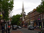 Upper Street is the main shopping street of the Islington
borough of inner north London. It runs roughly north from Islington High Street to Highbury Corner. The hilltop village of Islington originally consisted of two streets in addition to the High Street: Upper Street and Lower Street, which diverged from the High Street at Islington Green
and both date back to at least the 12th century. The fields around Upper Street, with their close proximity to the growing city of London, were a major farming area. Islington was the home of the Royal Agricultural Hall, and a number of pubs and shops existed along the street to serve farmers and visitors to the hall. In the 18th century Upper Street began to be redeveloped from an agricultural to a residential area. Ten houses were built in 1768 (later named Hornsey Row), and a further group built immediately south of Hornsey Row in 1792. Upper Street is one of the few streets in London (along with adjoining Liverpool Road
) to have a "high pavement". This was constructed to protect pedestrians from being splashed by the large numbers of animals using the road to reach the Royal Agricultural Hall; as a consequence, the pavement
of the street is approximately 1 m above the road surface for some of the length of the street.
 After reaching the eight-way Highbury Corner interchange, the A1 turns north-west as Holloway Road
. The origins of the name are unclear; it may derive from "hollow" due to the dip in the road, or from "hallow
" in relation to being part of the pilgrimage
route to Walsingham
. The earliest record giving the name of the road as The Holloway dates from 1307. The main stretch of Holloway Road runs through the site of the villages of Tollington and Stroud. The exact time of their founding is not known, but the earliest record of them dates from 1000. The names ceased to be used by the late 17th century, but are still preserved in the local place names "Tollington Park" and "Stroud Green"; since that time, the area has been known as Holloway
.
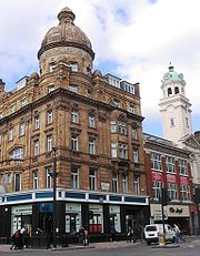
The northern point of Holloway Road is the complex interchange at Archway. The construction of the interchange left a few buildings isolated in the centre of the roundabout
, including the Archway Tavern, which appears on the cover of The Kinks
' 1971 album Muswell Hillbillies
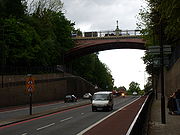
. After the Archway roundabout, the A1 enters a cutting, and becomes Archway Road. The traditional Great North Road at this point heads north-west up a very steep Highgate Hill (now the B519) to the village of Highgate
. By the early 19th century, this was proving unsuitable for increasingly heavy traffic, and the new Archway Road, crossing the hill at a shallower gradient
, was authorised in 1810, financed by tolls
. The easier ascent was made possible by a cutting and tunnel; the tunnel collapsed and instead the road bridge was built over the road which gives it its name. The tolls were abolished in 1876 and traffic increased substantially thereafter, particularly after the introduction of tram
s on the road. An inquiry was held into widening the section from the Archway intersection to the Hornsey Lane Bridge to dual 3 lanes in 1969 and work start in 1971. It was originally intended to widen a further section of the road, however severe disruption led to the first inquiry being abandoned in 1978 and a second in 1984. Air Marshal Sir Michael Giddings
chaired the inquiry concerning the second expansion. This is generally considered the first successful modern road protest
in the UK.
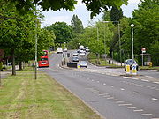
 The road passes north in cutting in a short dual carriageway
with bus lanes through Highgate Hill and under Hornsey Lane before narrowing back to a single carriageway
and passing through the eastern end of Haringey
. It then veers northeast, crossing the original route of the Great North Road at a point just west of Highgate Wood
.
With the influx of Jews
to London in the early 20th century, Archway Road became a focal point of London's Jewish community. Highgate Synagogue opened in 1930 at 88 Archway Road, and moved to 200 Archway Road in 1950.
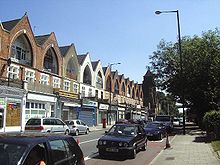
While Archway Road is an important shopping street, it lacks the large supermarkets and superstores of Holloway Road, and instead retains long rows of small specialist shops.
The large Jacksons Lane
Centre, built in a large converted church near the peak of the hill, is one of north London's leading community arts venues.
 During Thomas Telford
's construction of Archway Road, it was originally intended that it would pass through Highgate Hill in a tunnel
. However, the tunnel collapsed, leaving an inadvertent cutting through the hill. In 1813, John Nash
built a bridge, known as the Archway, to carry the ancient Hornsey Lane over the cutting. Between 1897 and 1900, Nash's bridge was replaced with the present cast-iron structure, officially called the "Hornsey Lane Bridge" but locally known as Suicide Bridge. Suicide Bridge is, as the name would suggest, noted to be a significant suicide bridge
. It was the subject of Johnny Burke's 2006 film The Bridge.
Following the suicides, by jumping from the bridge, of three young men in just over three weeks at the end of 2010, a campaign was set up by local residents to demand that better anti-suicide measures be put in place.
Based on extensive research campaigners believe that the best measures to prevent suicides at the bridge would be an anti-suicide net (used successfully in other parts of Europe), an 'S.O.S' telephone providing a direct line to the Samaritans (a measure that used to be in place at the site) and improved signage regarding sources of help. As one of the locations in London most associated with depression and mental illness, Suicide Bridge was the venue for the mental illness campaign group Mad Pride's inaugural vigil.
The bridge is accessible from the Archway Road level by a steep flight of steps and as one of the highest points in London, it offers impressive views over London and is a popular spot for photographers.
Hornsey Lane Bridge marks the boundary between Islington
and Haringey
, and consequently the official boundary between Inner London
and Outer London
. Although technically the boundary runs down the centre of the bridge, in practice the bridge is treated as part of Haringey and the land beneath it as part of Islington.
is today a minor stop on the Northern Line
, under the Northern Heights project, part of the New Works Programme
of the 1930s, it was to have become a major transport interchange. Only the low-level Northern Line station is now in use; however, Charles Holden
's abandoned and derelict high-level interchange station remains standing and can be seen from the footpath parallel to Archway Road leading north from the station entrance. On a clear day, the outlines of the London Underground roundel
can still be seen on the brickwork of the station platforms. The abandoned railway lines south to Finsbury Park and north to Muswell Hill
were converted to pathways in the 1970s, and remain open today as the "Parkland Walk".
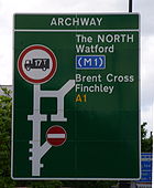
 At the northern end of Archway Road, the road re-intersects with the traditional Great North Road route (at this point called "North Hill"). The roads almost immediately re-diverge, with the Great North Road route heading north as the A1000
towards Finchley
, Whetstone
and Barnet
and the A1 heading west as Aylmer Road. The two routes do not meet again until they converge at Hatfield
, well to the north of London.
Aylmer Road is a very short stretch of road, running west for less than half a mile between the junction with the A1000 in Haringey
to the junction with The Bishop's Avenue
in Barnet
, where it becomes Lyttelton Road. The entire southern side of the road is taken up by Highgate Golf Course, while the northern side is a mixture of small shops, flats and allotments
.
The road is named for General Sir Fenton John Aylmer, VC KCB
, British commander at the Siege of Kut
in World War I
. He received the Victoria Cross
for his part in the assault on Nilt Fort on 2 December 1891.
following a land grant in 704. In 1894, the Church let building plots for construction of homes on the road. In the 20th century much of the land was sold by the Church, which now only owns one house on the road (46 The Bishop's Avenue) and a nearby residential home
.
Despite the relatively modest character of the surrounding area, this small 66-house street (and the parallel Winnington Road) have become the most expensive residential area in the world. In 2006, the smallest houses in the street were selling for £5 million ($10 million), while a larger house was sold in the same year for £50 million ($100 million). Ten of the houses are owned by the House of Saud
, whilst other notable owners of houses on the street include controversial businessman and fraudster Gerald Ronson
, pornography and newspaper magnate Richard Desmond
(owner of two houses) and billionaire
industrialist Lakshmi Mittal
.
 The road was repeatedly mentioned in Elton John
's 1988 reworking of Give Peace a Chance
("Why not talk about Bishop's Avenue/I've got a lovely house on Bishop's Avenue").
, and runs east–west along the northern foot of Highgate Hill between Hampstead Garden Suburb
and East Finchley
.
Lyttelton Road is for the most part a nondescript residential road, beginning at the end of Deacons Rise, Deacons Rise being characterised by large detached houses built with the road in the 1930s. Due to high traffic on the road and consequent noise and pollution, the flats are set much further back from the road than is typical for English housing, leading to extremely wide pavements and verges in addition to large front gardens. These flat prices are lower than on surrounding streets, with flats typically selling for around a tenth of the price of homes on the adjoining The Bishop's Avenue and Winnington Road.
On the northern side of Lyttelton road stands the Belvedere Court
block of flats. Built with the road in the 1930s, the building is now Grade II Listed as a leading example of 1930s architecture.
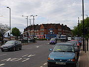
As the name suggests, Market Place was formerly the site of a street market. Whilst no trace of the market now remains other than the name, this short stretch of road is still an important shopping district and the site of the local post office
and library
.
 Immediately west of Market Place the A1 becomes Falloden Way, which runs west before turning northwest and converging with the North Circular Road
. Falloden Way was built between 1914 as part of a programme of planned extensions to Hampstead Garden Suburb
and runs on embankment
due to a dip in the ground caused by the valley of Mutton Brook
, which runs parallel to the road immediately to the south for its entire length. The north side of the road is occupied by 1930s housing blocks, whilst the southern side is occupied by a narrow strip of parkland following the brook, and by the northern tip of Big Wood and Little Wood (see below).
Falloden Way is a notoriously dangerous stretch of road. The layout of bus stops and misunderstanding/ignoring of rules regarding their use means buses are often forced to turn sharply out of the stops into fast moving traffic or to stop short of the bus stops presenting a hazard to other drivers. Additionally, the layout of pedestrian crossings mean a number of pedestrians attempt to run across the road rather than make their way to the inconveniently sited crossings. In 2006 two bus stops were suspended from use due to the hazards caused by traffic having to cross onto the wrong carriageway to pass stopped buses.
motor dealer once located at the junction. The A406
runs from the northeast to converge with the A1 from the southeast. The roads run concurrently
to a junction with the A598 north–south road, known as Finchley Road
to the south of the junction and Regents Park Road to the north. The roads continue as a concurrency to the west, past the enormous Finchley Synagogue before diverging; the A406 turns sharply south to parallel Dollis Brook
to Brent Cross
, while the A1 turns northwest as Great North Way. Seven smaller roads also meet the A1 along the Henlys Corner stretch of road, while a complex system of subways
beneath the interchange connect the various pedestrian footways.
Due to concerns about the safety of the underpasses, a number of people prefer to cross at surface level, leading to a number of serious road traffic accidents at the junction. There has been a sustained campaign in recent years to replace the subways with pedestrian crossing
s or footbridge
s.
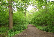 Immediately south of Falloden Way are twin patches of woodland known as Big Wood and Little Wood. They are two of the few surviving remnants of the ancient woodland
that once covered what is now north London. Big Wood covers a little over 7 hectares (70,000m²) while Little Wood covers around 2 hectares (20,000m²). In 704 Wealdheri, Bishop of London
was granted the land in the area by Tyrhtel, Bishop of Hereford
. From the 8th century until 1933 the land continued to belong to the Bishop of London, the western edge of Big Wood marking the edge of the estate. At the time of the Domesday Book
, the land was noted as being "capable of supporting 1000 pigs". Over the years the forest was gradually cleared, leaving twin patches of isolated woodland. The exact dates are not known, but it is known that Big Wood and Little Wood were separated by fields by 1767. In 1907, the woods became surrounded by the newly built town of Hampstead Garden Suburb
. Ownership of the land was ceded by the Bishop of London to the newly created Municipal Borough of Finchley
in 1933, which in 1965 passed to its successor, the London Borough of Barnet
.
Big Wood is dominated by large oak
trees. It also contains one of London's highest concentrations of the relatively rare sorbus tree
, the wild service tree, while the undergrowth is dominated by ivy
, yellow archangel
, bluebells
and guelder roses
. As a relatively isolated patch of woodland, it attracts large numbers of birds now rarely seen in the rest of London, particularly owl
s and the green woodpecker
. The current gates to the wood on the western boundary are the Hampstead Garden Suburb war memorial
and commemorate the 29 local residents who died in the Second World War. The nearby Little Wood, now separated from Big Wood by housing, is the site of an open-air theatre built in 1920 and now used in July by the Garden Suburb Theatre
. Big Wood and Little Wood are together a Local Nature Reserve
, Borough Grade I, owned and managed by Barnet Council
. The nearby Park Farm, on the opposite side of Falloden Way, was owned by circus proprietor "Lord" George Sanger between 1904 and Sanger's murder in 1911. Prior to the construction of the Denman's Drive housing on the field between Little and Big Woods, the field was used for grazing elephants.
stadium
, a number of tennis court
s, the ground of Hendon RFC
, a full golf course
, a Powerleague centre and, unusually, a large cemetery
.
synagogue
s, with seats for 1,350. While a synagogue has stood on the site since 1935, the current building dates from 1967.
at Fiveways Corner. As most traffic leaves the A1 at this point to join the motorway, the road narrows north of this point. Immediately after passing Fiveways Corner, the A1 turns sharply north under the name of Watford Way and continues via Mill Hill Circus to Apex Corner.
Watford Way itself actually runs northwards from Brent Cross
, well to the south. However, that section south of Fiveways Corner is designated as part of the A41
and is not part of the A1. Between Fiveways Corner and Apex Corner (see below) the A1 and A41 overlap.
As the stretch of Watford Way north of Fiveways Corner was built as a bypass
in 1930, and is also very close to the noisy and polluting M1, there is very little construction along this stretch of road.
. The A1 and A41 separate, with the A1 turning to run straight north and the A41 turning west, while Selvage Lane runs southwest to Mill Hill
and Marsh Lane runs northeast to Totteridge
. Although Apex Corner is adjacent to the M1, there is no interchange with the motorway.
As the car parks of shops at Apex Corner overlook the Midland Main Line
, the location is extremely popular with trainspotters.
.
The northbound carriageway passes the entrance to Scratchwood
, an area of ancient forest which is now a Local Nature Reserve
. Scratchwood Services, now re-named London Gateway services
, was named after the nature reserve. Opposite Scratchwood, off the southbound carriageway, is Moat Mount Open Space
, another nature reserve has a picnic area and a tree trail. A large camping and outdoor activity complex for schools, youth groups and probation services
was opened in 1997,
After passing Scratchwood, the A1 crosses the A411 from Watford
to Barnet
at the Stirling Corner roundabout, skirting Borehamwood
, before turning northeast and running through open countryside to Bignell's Corner.
The "Thatched Barn
" on the Barnet Bypass north of Stirling Corner is reported to have been a secret Special Operations Executive
base during World War II
.
The Barnet Bypass was also the location of one of the last Metropolitan Police
Police box
es in use (prior to the reintroduction of a single new box in Earl's Court in 1996). The box was taken out of use in 1981, seriously inconveniencing the filming of the Doctor Who
story Logopolis
which required a functioning police box as a key element and was intended to be filmed at the spot.
at a large roundabout (also sometimes referred to as South Mimms owing to the Motorway Service Area
at the site. North of Bignell's Corner the A1 becomes the A1(M) motorway, and rejoins the historic Great North Road route, running north to Edinburgh
(see A1 road (Great Britain)).
North London
North London is the northern part of London, England. It is an imprecise description and the area it covers is defined differently for a range of purposes. Common to these definitions is that it includes districts located north of the River Thames and is used in comparison with South...
. It runs from London Wall
London Wall
London Wall was the defensive wall first built by the Romans around Londinium, their strategically important port town on the River Thames in what is now the United Kingdom, and subsequently maintained until the 18th century. It is now the name of a road in the City of London running along part of...
to Bignell's Corner, where it crosses the M25
M25 motorway
The M25 motorway, or London Orbital, is a orbital motorway that almost encircles Greater London, England, in the United Kingdom. The motorway was first mooted early in the 20th century. A few sections, based on the now abandoned London Ringways plan, were constructed in the early 1970s and it ...
and becomes the A1(M) motorway
A1(M) motorway
The A1 is a motorway in England that upgrades sections of the A1 road that connects London, the capital of England and the United Kingdom, with Edinburgh, the capital of Scotland...
, alternating with the A1 as it continues to Edinburgh
Edinburgh
Edinburgh is the capital city of Scotland, the second largest city in Scotland, and the eighth most populous in the United Kingdom. The City of Edinburgh Council governs one of Scotland's 32 local government council areas. The council area includes urban Edinburgh and a rural area...
. The London section of the road passes through four London Boroughs
London borough
The administrative area of Greater London contains thirty-two London boroughs. Inner London comprises twelve of these boroughs plus the City of London. Outer London comprises the twenty remaining boroughs of Greater London.-Functions:...
: the City of London
City of London
The City of London is a small area within Greater London, England. It is the historic core of London around which the modern conurbation grew and has held city status since time immemorial. The City’s boundaries have remained almost unchanged since the Middle Ages, and it is now only a tiny part of...
, Islington
London Borough of Islington
The London Borough of Islington is a London borough in Inner London. It was formed in 1965 by merging the former metropolitan boroughs of Islington and Finsbury. The borough contains two Westminster parliamentary constituencies, Islington North and Islington South & Finsbury...
, Haringey
London Borough of Haringey
The London Borough of Haringey is a London borough, in North London, classified by some definitions as part of Inner London, and by others as part of Outer London. It was created in 1965 by the amalgamation of three former boroughs. It shares borders with six other London boroughs...
and Barnet
London Borough of Barnet
The London Borough of Barnet is a London borough in North London and forms part of Outer London. It has a population of 331,500 and covers . It borders Hertfordshire to the north and five other London boroughs: Harrow and Brent to the west, Camden and Haringey to the south-east and Enfield to the...
. Whilst the route of the A1 outside London closely follows the historic route of the Great North Road
Great North Road (Great Britain)
The Great North Road was a coaching route used by mail coaches between London, York and Edinburgh. The modern A1 mainly follows the Great North Road. The inns on the road, many of which survive, were staging posts on the coach routes, providing accommodation, stabling for the horses and...
, the London section for the most part does not.
Most of the current route of the London section of the A1 road was designated as such in 1927. It comprises a number of historic streets in central London and the former suburbs of Islington
Islington
Islington is a neighbourhood in Greater London, England and forms the central district of the London Borough of Islington. It is a district of Inner London, spanning from Islington High Street to Highbury Fields, encompassing the area around the busy Upper Street...
, Holloway
Holloway, London
Holloway is an inner-city district in the London Borough of Islington located north of Charing Cross and follows for the most part, the line of the Holloway Road . At the centre of Holloway is the Nag's Head area...
and Highgate
Highgate
Highgate is an area of North London on the north-eastern corner of Hampstead Heath.Highgate is one of the most expensive London suburbs in which to live. It has an active conservation body, the Highgate Society, to protect its character....
and long stretches of purpose-built new roads in the outer London borough of Barnet
London Borough of Barnet
The London Borough of Barnet is a London borough in North London and forms part of Outer London. It has a population of 331,500 and covers . It borders Hertfordshire to the north and five other London boroughs: Harrow and Brent to the west, Camden and Haringey to the south-east and Enfield to the...
, built to divert traffic away from the congested suburbs of Finchley
Finchley
Finchley is a district in Barnet in north London, England. Finchley is on high ground, about north of Charing Cross. It formed an ancient parish in the county of Middlesex, becoming a municipal borough in 1933, and has formed part of Greater London since 1965...
and High Barnet.
The London section of the A1 is one of London's most important roads. It links North London to the M1 motorway
M1 motorway
The M1 is a north–south motorway in England primarily connecting London to Leeds, where it joins the A1 near Aberford. While the M1 is considered to be the first inter-urban motorway to be completed in the United Kingdom, the first road to be built to motorway standard in the country was the...
and the A1(M) motorway, and consequently serves as Central London's primary road transport artery to the Midlands
English Midlands
The Midlands, or the English Midlands, is the traditional name for the area comprising central England that broadly corresponds to the early medieval Kingdom of Mercia. It borders Southern England, Northern England, East Anglia and Wales. Its largest city is Birmingham, and it was an important...
, Northern England
Northern England
Northern England, also known as the North of England, the North or the North Country, is a cultural region of England. It is not an official government region, but rather an informal amalgamation of counties. The southern extent of the region is roughly the River Trent, while the North is bordered...
and Scotland. It also connects a number of major areas within London, and sections of it serve as the High Street
High Street
High Street, or the High Street, is a metonym for the generic name of the primary business street of towns or cities, especially in the United Kingdom. It is usually a focal point for shops and retailers in city centres, and is most often used in reference to retailing...
for many of the now-joined villages that make up north London.
History
The A1 is the latest in a series of routes north from London to YorkYork
York is a walled city, situated at the confluence of the Rivers Ouse and Foss in North Yorkshire, England. The city has a rich heritage and has provided the backdrop to major political events throughout much of its two millennia of existence...
and beyond, and was formed in 1921 by the Ministry of Transport
Department for Transport
In the United Kingdom, the Department for Transport is the government department responsible for the English transport network and a limited number of transport matters in Scotland, Wales and Northern Ireland which are not devolved...
as part of the Great Britain road numbering scheme
Great Britain road numbering scheme
The Great Britain road numbering scheme is a numbering scheme used to classify and identify all roads in Great Britain. Each road is given a single letter, which represents the road's category, and a subsequent number, with a length of between 1 and 4 digits. Originally introduced to arrange...
. The earliest documented northern routes are the roads created by the Romans
Roman roads in Britain
Roman roads, together with Roman aqueducts and the vast standing Roman army , constituted the three most impressive features of the Roman Empire. In Britain, as in other provinces, the Romans constructed a comprehensive network of paved trunk roads Roman roads, together with Roman aqueducts and the...
during the period 43 to 410 AD, which consisted of a variety of "Iters" on the Antonine Itinerary
Antonine Itinerary
The Antonine Itinerary is a register of the stations and distances along the various roads of the Roman empire, containing directions how to get from one Roman settlement to another...
, a combination of which were used by the Anglo-Saxons as the route from London to York, and which became known as Ermine Street
Ermine Street
Ermine Street is the name of a major Roman road in England that ran from London to Lincoln and York . The Old English name was 'Earninga Straete' , named after a tribe called the Earningas, who inhabited a district later known as Armingford Hundred, around Arrington, Cambridgeshire and Royston,...
. Ermine Street later became known as the Old North Road, and is used within London by the current A10. By the 12th century, because of flooding and damage by traffic, an alternative route out of London was found through Muswell Hill
Muswell Hill
Muswell Hill is a suburb of north London, mostly in the London Borough of Haringey. It is situated about north of Charing Cross and around from the City of London. Muswell Hill is in the N10 postal district and mostly in the Hornsey and Wood Green parliamentary constituency.- History :The...
, and became part of the Great North Road
Great North Road (Great Britain)
The Great North Road was a coaching route used by mail coaches between London, York and Edinburgh. The modern A1 mainly follows the Great North Road. The inns on the road, many of which survive, were staging posts on the coach routes, providing accommodation, stabling for the horses and...
. A turnpike road, New North Road and Canonbury Road (A1200 road
A1200 road
The A1200 is an A road in the London Borough of Islington connecting Highbury & Islington station and Moorfields Eye Hospital. The link road consists of Canonbury Road and New North Road, then becomes East Road for a short distance, before meeting up with City Road near Moorfields Eye Hospital and...
), was constructed in 1812 linking the start of the Old North Road around Shoreditch
Shoreditch
Shoreditch is an area of London within the London Borough of Hackney in England. It is a built-up part of the inner city immediately to the north of the City of London, located east-northeast of Charing Cross.-Etymology:...
with the Great North Road at Highbury Corner.
While the route of the A1 outside London mainly follows the Great North Road route used by mail coaches between London and Edinburgh, within London the coaching route is only followed through Islington. During the early 1970s plans to widen the A1 along the Archway Road section were abandoned after considerable opposition and four public inquiries during which road protesters disrupted proceedings. The scheme was finally dropped in 1990.
Route
The route of the A1 runs from London WallLondon Wall
London Wall was the defensive wall first built by the Romans around Londinium, their strategically important port town on the River Thames in what is now the United Kingdom, and subsequently maintained until the 18th century. It is now the name of a road in the City of London running along part of...
to Bignell's Corner, where it crosses the M25
M25 motorway
The M25 motorway, or London Orbital, is a orbital motorway that almost encircles Greater London, England, in the United Kingdom. The motorway was first mooted early in the 20th century. A few sections, based on the now abandoned London Ringways plan, were constructed in the early 1970s and it ...
and becomes the A1(M) motorway
A1(M) motorway
The A1 is a motorway in England that upgrades sections of the A1 road that connects London, the capital of England and the United Kingdom, with Edinburgh, the capital of Scotland...
, alternating with the A1 as it continues to Edinburgh
Edinburgh
Edinburgh is the capital city of Scotland, the second largest city in Scotland, and the eighth most populous in the United Kingdom. The City of Edinburgh Council governs one of Scotland's 32 local government council areas. The council area includes urban Edinburgh and a rural area...
. The London section of the road passes through four London Boroughs
London borough
The administrative area of Greater London contains thirty-two London boroughs. Inner London comprises twelve of these boroughs plus the City of London. Outer London comprises the twenty remaining boroughs of Greater London.-Functions:...
: the City of London
City of London
The City of London is a small area within Greater London, England. It is the historic core of London around which the modern conurbation grew and has held city status since time immemorial. The City’s boundaries have remained almost unchanged since the Middle Ages, and it is now only a tiny part of...
, Islington
London Borough of Islington
The London Borough of Islington is a London borough in Inner London. It was formed in 1965 by merging the former metropolitan boroughs of Islington and Finsbury. The borough contains two Westminster parliamentary constituencies, Islington North and Islington South & Finsbury...
, Haringey
London Borough of Haringey
The London Borough of Haringey is a London borough, in North London, classified by some definitions as part of Inner London, and by others as part of Outer London. It was created in 1965 by the amalgamation of three former boroughs. It shares borders with six other London boroughs...
and Barnet
London Borough of Barnet
The London Borough of Barnet is a London borough in North London and forms part of Outer London. It has a population of 331,500 and covers . It borders Hertfordshire to the north and five other London boroughs: Harrow and Brent to the west, Camden and Haringey to the south-east and Enfield to the...
.
City of London
London Wall
London Wall was the defensive wall first built by the Romans around Londinium, their strategically important port town on the River Thames in what is now the United Kingdom, and subsequently maintained until the 18th century. It is now the name of a road in the City of London running along part of...
, next to the Museum of London
Museum of London
The Museum of London documents the history of London from the Prehistoric to the present day. The museum is located close to the Barbican Centre, as part of the striking Barbican complex of buildings created in the 1960s and 70s as an innovative approach to re-development within a bomb damaged...
. Aldersgate Street runs north from here to the northern border of the City of London
City of London
The City of London is a small area within Greater London, England. It is the historic core of London around which the modern conurbation grew and has held city status since time immemorial. The City’s boundaries have remained almost unchanged since the Middle Ages, and it is now only a tiny part of...
, where it becomes Goswell Road. Adjacent to the modern roundabout
Roundabout
A roundabout is the name for a road junction in which traffic moves in one direction around a central island. The word dates from the early 20th century. Roundabouts are common in many countries around the world...
on the site of the Aldersgate is the former headquarters of the General Post Office (closed in 1910 and demolished shortly afterwards), and the adjoining Postman's Park
Postman's Park
Postman's Park is a park in central London, a short distance north of St Paul's Cathedral. Bordered by Little Britain, Aldersgate Street, King Edward Street, and the site of the former head office of the General Post Office , it is one of the largest parks in the City of London, the walled city...
. Most of the buildings on Aldersgate Street were destroyed or badly damaged during the Blitz
The Blitz
The Blitz was the sustained strategic bombing of Britain by Nazi Germany between 7 September 1940 and 10 May 1941, during the Second World War. The city of London was bombed by the Luftwaffe for 76 consecutive nights and many towns and cities across the country followed...
of the Second World War. The entire length of the eastern side of the street is now occupied by the 40 acre (162,000m²) Barbican Estate
Barbican Estate
The Barbican Estate is a residential estate built during the 1960s and the 1970s in the City of London, in an area once devastated by World War II bombings and today densely populated by financial institutions...
, an arts complex and residential estate.
Islington
London Borough of Islington
The London Borough of Islington is a London borough in Inner London. It was formed in 1965 by merging the former metropolitan boroughs of Islington and Finsbury. The borough contains two Westminster parliamentary constituencies, Islington North and Islington South & Finsbury...
at Goswell Road
Goswell Road
Goswell Road is a road in the south of the London Borough of Islington. It runs north from the border of the City of London through Clerkenwell, crossing Old Street to The Angel....
, running north from the border of the City of London
City of London
The City of London is a small area within Greater London, England. It is the historic core of London around which the modern conurbation grew and has held city status since time immemorial. The City’s boundaries have remained almost unchanged since the Middle Ages, and it is now only a tiny part of...
to The Angel
The Angel, Islington
Angel is a district of London, England, and part of the London Borough of Islington. The area is identified in the London Plan as one of 35 major centres in Greater London.-History:...
. The origins of the Goswell name are unclear, with some sources claiming the road was named after a nearby garden called 'Goswelle' or 'Goderell' which belonged to Robert de Ufford, 1st Earl of Suffolk, whilst others state it derives from "God's Well", and the traditional pagan practice of well-worship. The road is mostly occupied by offices and shops, and by the main campus of City University London
City University, London
City University London , is a public research university located in London, United Kingdom. It was founded in 1894 as the Northampton Institute and became a university in 1966, when it adopted its present name....
. The New River
New River (England)
The New River is an artificial waterway in England, opened in 1613 to supply London with fresh drinking water taken from the River Lea and from Amwell Springs , and other springs and wells along its course....
originally passed along Goswell Road before turning to terminate at New River Head on Rosebery Avenue. The course of the river at this point is now entirely underground, and no trace of it can be seen at the surface.
The route merges briefly with City Road
City Road
City Road or The City Road is a road that runs through inner north and central London. The northwestern extremity of the road is at the Angel, Islington where it forms a continuation of Pentonville Road. Pentonville Road itself is the modern name for London's first bypass, the New Road from...
, before turning right at The Angel
The Angel, Islington
Angel is a district of London, England, and part of the London Borough of Islington. The area is identified in the London Plan as one of 35 major centres in Greater London.-History:...
to go along Upper Street. The start of Upper Street is called Islington High Street. The earliest reference to Islington High Street is its appearance on a 1590 map of the area. At this time, nine inns (including the Angel, which has subsequently given its name to the area), as well as housing and a public pond were shown lining the street. In 1716 Islington High Street came under the control of the newly formed Islington Turnpike Trust. The Trust grew rapidly, and soon had control of most major roads in the area, building a number of major road arteries through the expanding residential areas, including Caledonian Road
Caledonian Road (London)
The Caledonian Road, in Islington, North London is a road, about one and half miles long, running north-south from Camden Road near the junction with Holloway Road to Pentonville Road in the south. It is often known colloquially as the "Cally" and forms the entirety of the A5203.The street is...
, Euston Road
Euston Road
Euston Road is an important thoroughfare in central London, England, and forms part of the A501. It is part of the New Road from Paddington to Islington, and was opened as part of the New Road in 1756...
, City Road
City Road
City Road or The City Road is a road that runs through inner north and central London. The northwestern extremity of the road is at the Angel, Islington where it forms a continuation of Pentonville Road. Pentonville Road itself is the modern name for London's first bypass, the New Road from...
and New North Road. The Peacock Inn at 11 Islington High Street dates from 1564, although the current facade
Facade
A facade or façade is generally one exterior side of a building, usually, but not always, the front. The word comes from the French language, literally meaning "frontage" or "face"....
dates from 1857. It featured in Tom Brown's Schooldays
Tom Brown's Schooldays
Tom Brown's Schooldays is a novel by Thomas Hughes. The story is set at Rugby School, a public school for boys, in the 1830s; Hughes attended Rugby School from 1834 to 1842...
as the inn at which Tom stays prior to travelling to Rugby
Rugby School
Rugby School is a co-educational day and boarding school located in the town of Rugby, Warwickshire, England. It is one of the oldest independent schools in Britain.-History:...
. It closed in 1962, although the building still stands.
Islington
Islington is a neighbourhood in Greater London, England and forms the central district of the London Borough of Islington. It is a district of Inner London, spanning from Islington High Street to Highbury Fields, encompassing the area around the busy Upper Street...
borough of inner north London. It runs roughly north from Islington High Street to Highbury Corner. The hilltop village of Islington originally consisted of two streets in addition to the High Street: Upper Street and Lower Street, which diverged from the High Street at Islington Green
Islington Green
Islington Green is a small triangle of open land at the convergence of Upper Street and Essex Road in the London Borough of Islington...
and both date back to at least the 12th century. The fields around Upper Street, with their close proximity to the growing city of London, were a major farming area. Islington was the home of the Royal Agricultural Hall, and a number of pubs and shops existed along the street to serve farmers and visitors to the hall. In the 18th century Upper Street began to be redeveloped from an agricultural to a residential area. Ten houses were built in 1768 (later named Hornsey Row), and a further group built immediately south of Hornsey Row in 1792. Upper Street is one of the few streets in London (along with adjoining Liverpool Road
Liverpool Road
Liverpool Road is located in the London Borough of Islington of inner north London. Liverpool Road runs parallel to Upper Street and is largely made up of Georgian architecture. It starts at Upper Street and joins Holloway Road....
) to have a "high pavement". This was constructed to protect pedestrians from being splashed by the large numbers of animals using the road to reach the Royal Agricultural Hall; as a consequence, the pavement
Sidewalk
A sidewalk, or pavement, footpath, footway, and sometimes platform, is a path along the side of a road. A sidewalk may accommodate moderate changes in grade and is normally separated from the vehicular section by a curb...
of the street is approximately 1 m above the road surface for some of the length of the street.
Holloway Road
Holloway Road is a road in London. It is one of the main shopping streets in North London, and carries the A1 road as it passes through Holloway, in the London Borough of Islington...
. The origins of the name are unclear; it may derive from "hollow" due to the dip in the road, or from "hallow
Hallow
To hallow is "to make holy or sacred, to sanctify or consecrate, to venerate". The adjective form hallowed, as used in The Lord's Prayer, means holy, consecrated, sacred, or revered.-Etymology:...
" in relation to being part of the pilgrimage
Pilgrimage
A pilgrimage is a journey or search of great moral or spiritual significance. Typically, it is a journey to a shrine or other location of importance to a person's beliefs and faith...
route to Walsingham
Walsingham
Walsingham is a village in the English county of Norfolk. The village is famed for its religious shrines in honour of the Virgin Mary and as a major pilgrimage centre...
. The earliest record giving the name of the road as The Holloway dates from 1307. The main stretch of Holloway Road runs through the site of the villages of Tollington and Stroud. The exact time of their founding is not known, but the earliest record of them dates from 1000. The names ceased to be used by the late 17th century, but are still preserved in the local place names "Tollington Park" and "Stroud Green"; since that time, the area has been known as Holloway
Holloway, London
Holloway is an inner-city district in the London Borough of Islington located north of Charing Cross and follows for the most part, the line of the Holloway Road . At the centre of Holloway is the Nag's Head area...
.
The northern point of Holloway Road is the complex interchange at Archway. The construction of the interchange left a few buildings isolated in the centre of the roundabout
Roundabout
A roundabout is the name for a road junction in which traffic moves in one direction around a central island. The word dates from the early 20th century. Roundabouts are common in many countries around the world...
, including the Archway Tavern, which appears on the cover of The Kinks
The Kinks
The Kinks were an English rock band formed in Muswell Hill, North London, by brothers Ray and Dave Davies in 1964. Categorised in the United States as a British Invasion band, The Kinks are recognised as one of the most important and influential rock acts of the era. Their music was influenced by a...
' 1971 album Muswell Hillbillies
Muswell Hillbillies
Muswell Hillbillies is the ninth studio album by the English rock group The Kinks, released in November 1971. The album is named after the Muswell Hill area of North London, where band leader Ray Davies and guitarist Dave Davies grew up and the band formed in the early 1960s.The album centred on...
. After the Archway roundabout, the A1 enters a cutting, and becomes Archway Road. The traditional Great North Road at this point heads north-west up a very steep Highgate Hill (now the B519) to the village of Highgate
Highgate
Highgate is an area of North London on the north-eastern corner of Hampstead Heath.Highgate is one of the most expensive London suburbs in which to live. It has an active conservation body, the Highgate Society, to protect its character....
. By the early 19th century, this was proving unsuitable for increasingly heavy traffic, and the new Archway Road, crossing the hill at a shallower gradient
Gradient
In vector calculus, the gradient of a scalar field is a vector field that points in the direction of the greatest rate of increase of the scalar field, and whose magnitude is the greatest rate of change....
, was authorised in 1810, financed by tolls
Toll road
A toll road is a privately or publicly built road for which a driver pays a toll for use. Structures for which tolls are charged include toll bridges and toll tunnels. Non-toll roads are financed using other sources of revenue, most typically fuel tax or general tax funds...
. The easier ascent was made possible by a cutting and tunnel; the tunnel collapsed and instead the road bridge was built over the road which gives it its name. The tolls were abolished in 1876 and traffic increased substantially thereafter, particularly after the introduction of tram
Tram
A tram is a passenger rail vehicle which runs on tracks along public urban streets and also sometimes on separate rights of way. It may also run between cities and/or towns , and/or partially grade separated even in the cities...
s on the road. An inquiry was held into widening the section from the Archway intersection to the Hornsey Lane Bridge to dual 3 lanes in 1969 and work start in 1971. It was originally intended to widen a further section of the road, however severe disruption led to the first inquiry being abandoned in 1978 and a second in 1984. Air Marshal Sir Michael Giddings
Michael Giddings
Air Marshal Sir Kenneth Charles Michael Giddings KCB, OBE, DFC, AFC & Bar was a senior Royal Air Force officer who served as a fighter pilot during the Second World War...
chaired the inquiry concerning the second expansion. This is generally considered the first successful modern road protest
Road protest (UK)
Road protest in the United Kingdom usually occurs as a reaction to a stated intention by the empowered authorities to build a new road, or to modify an existing road. Protests may also be made by those wishing to see new roads built or improvements made to existing roads. Motivations for protests...
in the UK.
Archway Road (after Hornsey Lane Bridge)
Dual carriageway
A dual carriageway is a class of highway with two carriageways for traffic travelling in opposite directions separated by a central reservation...
with bus lanes through Highgate Hill and under Hornsey Lane before narrowing back to a single carriageway
Single carriageway
A single carriageway is a road with 1, 2 or more lanes arranged within a single carriageway with no central reservation to separate opposing flows of traffic. Two-lane road or two-lane highway are single carriageway with one lane for each direction...
and passing through the eastern end of Haringey
London Borough of Haringey
The London Borough of Haringey is a London borough, in North London, classified by some definitions as part of Inner London, and by others as part of Outer London. It was created in 1965 by the amalgamation of three former boroughs. It shares borders with six other London boroughs...
. It then veers northeast, crossing the original route of the Great North Road at a point just west of Highgate Wood
Highgate Wood
Highgate Wood is a 28 hectare area of ancient woodland in North London, lying between East Finchley, Highgate Village, and Muswell Hill. It was originally part of the ancient Forest of Middlesex which covered much of London, Hertfordshire and Essex and was mentioned in the Domesday Book...
.
With the influx of Jews
Jews
The Jews , also known as the Jewish people, are a nation and ethnoreligious group originating in the Israelites or Hebrews of the Ancient Near East. The Jewish ethnicity, nationality, and religion are strongly interrelated, as Judaism is the traditional faith of the Jewish nation...
to London in the early 20th century, Archway Road became a focal point of London's Jewish community. Highgate Synagogue opened in 1930 at 88 Archway Road, and moved to 200 Archway Road in 1950.
While Archway Road is an important shopping street, it lacks the large supermarkets and superstores of Holloway Road, and instead retains long rows of small specialist shops.
The large Jacksons Lane
Jacksons Lane
- Theatre and performance :Jacksons Lane is a multi-arts venue in Highgate, North London. Housed in a striking red-brick gothic church conversion, the building is home to a 160 capacity theatre, a large scale dance and rehearsal studio, a cafe-bar and four other multi-purpose spaces.Jacksons Lane...
Centre, built in a large converted church near the peak of the hill, is one of north London's leading community arts venues.
Hornsey Lane Bridge
Thomas Telford
Thomas Telford FRS, FRSE was a Scottish civil engineer, architect and stonemason, and a noted road, bridge and canal builder.-Early career:...
's construction of Archway Road, it was originally intended that it would pass through Highgate Hill in a tunnel
Tunnel
A tunnel is an underground passageway, completely enclosed except for openings for egress, commonly at each end.A tunnel may be for foot or vehicular road traffic, for rail traffic, or for a canal. Some tunnels are aqueducts to supply water for consumption or for hydroelectric stations or are sewers...
. However, the tunnel collapsed, leaving an inadvertent cutting through the hill. In 1813, John Nash
John Nash (architect)
John Nash was a British architect responsible for much of the layout of Regency London.-Biography:Born in Lambeth, London, the son of a Welsh millwright, Nash trained with the architect Sir Robert Taylor. He established his own practice in 1777, but his career was initially unsuccessful and...
built a bridge, known as the Archway, to carry the ancient Hornsey Lane over the cutting. Between 1897 and 1900, Nash's bridge was replaced with the present cast-iron structure, officially called the "Hornsey Lane Bridge" but locally known as Suicide Bridge. Suicide Bridge is, as the name would suggest, noted to be a significant suicide bridge
Suicide bridge
A suicide bridge is a bridge used frequently to die by suicide, most typically by jumping off and into the water below ....
. It was the subject of Johnny Burke's 2006 film The Bridge.
Following the suicides, by jumping from the bridge, of three young men in just over three weeks at the end of 2010, a campaign was set up by local residents to demand that better anti-suicide measures be put in place.
Based on extensive research campaigners believe that the best measures to prevent suicides at the bridge would be an anti-suicide net (used successfully in other parts of Europe), an 'S.O.S' telephone providing a direct line to the Samaritans (a measure that used to be in place at the site) and improved signage regarding sources of help. As one of the locations in London most associated with depression and mental illness, Suicide Bridge was the venue for the mental illness campaign group Mad Pride's inaugural vigil.
The bridge is accessible from the Archway Road level by a steep flight of steps and as one of the highest points in London, it offers impressive views over London and is a popular spot for photographers.
Hornsey Lane Bridge marks the boundary between Islington
London Borough of Islington
The London Borough of Islington is a London borough in Inner London. It was formed in 1965 by merging the former metropolitan boroughs of Islington and Finsbury. The borough contains two Westminster parliamentary constituencies, Islington North and Islington South & Finsbury...
and Haringey
London Borough of Haringey
The London Borough of Haringey is a London borough, in North London, classified by some definitions as part of Inner London, and by others as part of Outer London. It was created in 1965 by the amalgamation of three former boroughs. It shares borders with six other London boroughs...
, and consequently the official boundary between Inner London
Inner London
Inner London is the name for the group of London boroughs which form the interior part of Greater London and are surrounded by Outer London. The area was first officially defined in 1965 and for purposes such as statistics, the definition has changed over time. The terms Inner London and Central...
and Outer London
Outer London
Outer London is the name for the group of London Boroughs that form a ring around Inner London.These were areas that were not part of the County of London and became formally part of Greater London in 1965...
. Although technically the boundary runs down the centre of the bridge, in practice the bridge is treated as part of Haringey and the land beneath it as part of Islington.
Highgate Station and the Northern Heights scheme
Although Highgate tube stationHighgate tube station
Highgate tube station is a London Underground station on Archway Road, Highgate, not far from Highgate Village in north London. It is on the High Barnet branch of the Northern Line, between Archway and East Finchley, in Travelcard Zone 3....
is today a minor stop on the Northern Line
Northern Line
The Northern line is a London Underground line. It is coloured black on the Tube map.For most of its length it is a deep-level tube line. The line carries 206,734,000 passengers per year. This is the highest number of any line on the London Underground system, but the Northern line is unique in...
, under the Northern Heights project, part of the New Works Programme
New Works Programme
The "New Works Programme, 1935 - 1940" was the major investment programme delivered by the London Passenger Transport Board , commonly known as London Transport, which had been created in 1933 to coordinate underground train, tram, trolleybus and bus services in the capital and the surrounding areas...
of the 1930s, it was to have become a major transport interchange. Only the low-level Northern Line station is now in use; however, Charles Holden
Charles Holden
Charles Henry Holden, Litt. D., FRIBA, MRTPI, RDI was a Bolton-born English architect best known for designing many London Underground stations during the 1920s and 1930s, for Bristol Central Library, the Underground Electric Railways Company of London's headquarters at 55 Broadway and for the...
's abandoned and derelict high-level interchange station remains standing and can be seen from the footpath parallel to Archway Road leading north from the station entrance. On a clear day, the outlines of the London Underground roundel
Roundel
A roundel in heraldry is a disc; the term is also commonly used to refer to a type of national insignia used on military aircraft, generally circular in shape and usually comprising concentric rings of different colours.-Heraldry:...
can still be seen on the brickwork of the station platforms. The abandoned railway lines south to Finsbury Park and north to Muswell Hill
Muswell Hill
Muswell Hill is a suburb of north London, mostly in the London Borough of Haringey. It is situated about north of Charing Cross and around from the City of London. Muswell Hill is in the N10 postal district and mostly in the Hornsey and Wood Green parliamentary constituency.- History :The...
were converted to pathways in the 1970s, and remain open today as the "Parkland Walk".
Aylmer Road
A1000 road
The A1000 is a main road in the United Kingdom, running north from Highgate, North London for approximately to Welwyn where it joins the A1 motorway. It incorporates part of the main medieval route out of London, and runs through Finchley, Whetstone, Chipping Barnet and Monken Hadley...
towards Finchley
Finchley
Finchley is a district in Barnet in north London, England. Finchley is on high ground, about north of Charing Cross. It formed an ancient parish in the county of Middlesex, becoming a municipal borough in 1933, and has formed part of Greater London since 1965...
, Whetstone
Whetstone, London
-Buses:* 34 - Barnet Church to Walthamstow Central bus/tube/railway station* 125 - Winchmore Hill to Finchley Central* 234 - Barnet to Highgate Wood * 251 - Edgware bus/tube station to Arnos Grove tube station...
and Barnet
Barnet
High Barnet or Chipping Barnet is a place in the London Borough of Barnet, North London, England. It is a suburban development built around a twelfth-century settlement and is located north north-west of Charing Cross. Its name is often abbreviated to Barnet, which is also the name of the London...
and the A1 heading west as Aylmer Road. The two routes do not meet again until they converge at Hatfield
Hatfield, Hertfordshire
Hatfield is a town and civil parish in Hertfordshire, England in the borough of Welwyn Hatfield. It has a population of 29,616, and is of Saxon origin. Hatfield House, the home of the Marquess of Salisbury, is the nucleus of the old town...
, well to the north of London.
Aylmer Road is a very short stretch of road, running west for less than half a mile between the junction with the A1000 in Haringey
London Borough of Haringey
The London Borough of Haringey is a London borough, in North London, classified by some definitions as part of Inner London, and by others as part of Outer London. It was created in 1965 by the amalgamation of three former boroughs. It shares borders with six other London boroughs...
to the junction with The Bishop's Avenue
The Bishop's Avenue
The Bishops Avenue, London N2, connects the north side of Hampstead Heath at Kenwood , Hampstead to East Finchley and is on the boundary of the London Boroughs of Barnet and Haringey. Average property prices on the avenue surpassed £1 million in the late 1980s and each property occupies a 2-3 acre...
in Barnet
London Borough of Barnet
The London Borough of Barnet is a London borough in North London and forms part of Outer London. It has a population of 331,500 and covers . It borders Hertfordshire to the north and five other London boroughs: Harrow and Brent to the west, Camden and Haringey to the south-east and Enfield to the...
, where it becomes Lyttelton Road. The entire southern side of the road is taken up by Highgate Golf Course, while the northern side is a mixture of small shops, flats and allotments
Allotment (gardening)
An allotment garden, often called simply an allotment, is a plot of land made available for individual, non-professional gardening. Such plots are formed by subdividing a piece of land into a few or up to several hundreds of land parcels that are assigned to individuals or families...
.
The road is named for General Sir Fenton John Aylmer, VC KCB
Fenton John Aylmer
Lieutenant General Sir Fenton John Aylmer, 13th Baronet of Donadea VC KCB was an English recipient of the Victoria Cross...
, British commander at the Siege of Kut
Siege of Kut
The siege of Kut Al Amara , was the besieging of 8,000 strong British-Indian garrison in the town of Kut, 100 miles south of Baghdad, by the Ottoman Army. Its known also as 1st Battle of Kut. In 1915, its population was around 6,500...
in World War I
World War I
World War I , which was predominantly called the World War or the Great War from its occurrence until 1939, and the First World War or World War I thereafter, was a major war centred in Europe that began on 28 July 1914 and lasted until 11 November 1918...
. He received the Victoria Cross
Victoria Cross
The Victoria Cross is the highest military decoration awarded for valour "in the face of the enemy" to members of the armed forces of various Commonwealth countries, and previous British Empire territories....
for his part in the assault on Nilt Fort on 2 December 1891.
The Bishops Avenue
Immediately before becoming Lyttelton Road, Aylmer Road crosses The Bishops Avenue. As with much of the surrounding area, this land was owned by the Bishop of LondonBishop of London
The Bishop of London is the ordinary of the Church of England Diocese of London in the Province of Canterbury.The diocese covers 458 km² of 17 boroughs of Greater London north of the River Thames and a small part of the County of Surrey...
following a land grant in 704. In 1894, the Church let building plots for construction of homes on the road. In the 20th century much of the land was sold by the Church, which now only owns one house on the road (46 The Bishop's Avenue) and a nearby residential home
Assisted living
Assisted living residences or assisted living facilities provide supervision or assistance with activities of daily living ; coordination of services by outside health care providers; and monitoring of resident activities to help to ensure their health, safety, and well-being.Assistance may...
.
Despite the relatively modest character of the surrounding area, this small 66-house street (and the parallel Winnington Road) have become the most expensive residential area in the world. In 2006, the smallest houses in the street were selling for £5 million ($10 million), while a larger house was sold in the same year for £50 million ($100 million). Ten of the houses are owned by the House of Saud
House of Saud
The House of Saud , also called the Al Saud, is the ruling royal family of Saudi Arabia and one of the wealthiest and most powerful dynasties in the world. The family holds thousands of members...
, whilst other notable owners of houses on the street include controversial businessman and fraudster Gerald Ronson
Gerald Ronson
Gerald Maurice Ronson is a British business tycoon and philanthropist.-Career:Aged 15, Ronson left school and joined his father in the family furniture business, named Heron after his father Henry. The company expanded into other activities; in the mid-1960s Ronson brought the first self-service...
, pornography and newspaper magnate Richard Desmond
Richard Desmond
Richard Clive Desmond is an English publisher and businessman. He is the owner of Express Newspapers and founder in 1974 of Northern & Shell, which publishes various celebrity magazines, such as OK! and New!, and British national newspapers Daily Star and Daily Express...
(owner of two houses) and billionaire
Billionaire
A billionaire, in countries that use the short scale number naming system, is a person who has a net worth of at least one billion units of a given currency, usually the United States dollar, Euro, or Pound sterling. Forbes magazine updates a complete list of U.S. dollar billionaires around the...
industrialist Lakshmi Mittal
Lakshmi Mittal
Lakshmi Narayan Mittal is an Indian steel magnate. He is the chairman and chief executive officer of ArcelorMittal, the world’s largest steelmaking company....
.
Elton John
Sir Elton Hercules John, CBE, Hon DMus is an English rock singer-songwriter, composer, pianist and occasional actor...
's 1988 reworking of Give Peace a Chance
Give Peace a Chance
"Give Peace a Chance" is a song written by John Lennon, originally under the moniker Lennon–McCartney, released as a single in 1969 by the Plastic Ono Band on Apple Records, catalogue Apple 13 in the United Kingdom, Apple 1809 in the United States. It is the first solo single issued by Lennon, and...
("Why not talk about Bishop's Avenue/I've got a lovely house on Bishop's Avenue").
Lyttelton Road
After crossing the Bishop's Avenue, the A1 becomes Lyttelton Road. Lyttelton Road was built in 1931 in an attempt to divert traffic away from the congested suburb of FinchleyFinchley
Finchley is a district in Barnet in north London, England. Finchley is on high ground, about north of Charing Cross. It formed an ancient parish in the county of Middlesex, becoming a municipal borough in 1933, and has formed part of Greater London since 1965...
, and runs east–west along the northern foot of Highgate Hill between Hampstead Garden Suburb
Hampstead Garden Suburb
-Notable Residents :*Theo Adams*Martin Bell*Sir Victor Blank*Katie Boyle*Constantine, the last King of Greece*Greg Davies*Richard & Judy Finnigan*David Matthews*Michael Ridpath*Claudia Roden*Jonathan Ross*Sir Donald Sinden*Marc Sinden...
and East Finchley
East Finchley
East Finchley is a suburb in the London Borough of Barnet, in north London, and situated north-west of Charing Cross. Geographically it is somewhat separate from the rest of Finchley, with North Finchley and West Finchley to the north, and Finchley Central to the west.- History :The land on which...
.
Lyttelton Road is for the most part a nondescript residential road, beginning at the end of Deacons Rise, Deacons Rise being characterised by large detached houses built with the road in the 1930s. Due to high traffic on the road and consequent noise and pollution, the flats are set much further back from the road than is typical for English housing, leading to extremely wide pavements and verges in addition to large front gardens. These flat prices are lower than on surrounding streets, with flats typically selling for around a tenth of the price of homes on the adjoining The Bishop's Avenue and Winnington Road.
On the northern side of Lyttelton road stands the Belvedere Court
Belvedere Court
Belvedere Court is a residential block of fifty six flats in Lyttelton Road, East Finchley, North London, England. It was designed by the architect Ernst Ludwig Freud and built by H Meckhonik, a London-based contractor in 1937/38...
block of flats. Built with the road in the 1930s, the building is now Grade II Listed as a leading example of 1930s architecture.
Market Place
After passing playing fields to the south, Lyttelton Road crosses Kingsley Way and becomes Market Place.As the name suggests, Market Place was formerly the site of a street market. Whilst no trace of the market now remains other than the name, this short stretch of road is still an important shopping district and the site of the local post office
Post office
A post office is a facility forming part of a postal system for the posting, receipt, sorting, handling, transmission or delivery of mail.Post offices offer mail-related services such as post office boxes, postage and packaging supplies...
and library
Library
In a traditional sense, a library is a large collection of books, and can refer to the place in which the collection is housed. Today, the term can refer to any collection, including digital sources, resources, and services...
.
Falloden Way
A406 road
The A406 or the North Circular Road is a road which crosses North London, UK, linking West and East London. It, together with the South Circular Road, forms a ring road through the inner part of Outer London...
. Falloden Way was built between 1914 as part of a programme of planned extensions to Hampstead Garden Suburb
Hampstead Garden Suburb
-Notable Residents :*Theo Adams*Martin Bell*Sir Victor Blank*Katie Boyle*Constantine, the last King of Greece*Greg Davies*Richard & Judy Finnigan*David Matthews*Michael Ridpath*Claudia Roden*Jonathan Ross*Sir Donald Sinden*Marc Sinden...
and runs on embankment
Embankment (transportation)
To keep a road or railway line straight or flat, and where the comparative cost or practicality of alternate solutions is prohibitive, the land over which the road or rail line will travel is built up to form an embankment. An embankment is therefore in some sense the opposite of a cutting, and...
due to a dip in the ground caused by the valley of Mutton Brook
Mutton Brook
Mutton Brook is a stream which runs between East Finchley and Hendon in the London Borough of Barnet. It is a tributary of the River Brent, which is itself a tributary of the River Thames....
, which runs parallel to the road immediately to the south for its entire length. The north side of the road is occupied by 1930s housing blocks, whilst the southern side is occupied by a narrow strip of parkland following the brook, and by the northern tip of Big Wood and Little Wood (see below).
Falloden Way is a notoriously dangerous stretch of road. The layout of bus stops and misunderstanding/ignoring of rules regarding their use means buses are often forced to turn sharply out of the stops into fast moving traffic or to stop short of the bus stops presenting a hazard to other drivers. Additionally, the layout of pedestrian crossings mean a number of pedestrians attempt to run across the road rather than make their way to the inconveniently sited crossings. In 2006 two bus stops were suspended from use due to the hazards caused by traffic having to cross onto the wrong carriageway to pass stopped buses.
Henlys Corner
The western end of Falloden Way is dominated by the complicated Henlys Corner interchange, named after the Henlys GroupHenlys Group
Henlys Group PLC was a car dealer that became a major player in the bus and coach business in both North America and England.-History:Henlys started life as a Jaguar and Rover dealer...
motor dealer once located at the junction. The A406
A406 road
The A406 or the North Circular Road is a road which crosses North London, UK, linking West and East London. It, together with the South Circular Road, forms a ring road through the inner part of Outer London...
runs from the northeast to converge with the A1 from the southeast. The roads run concurrently
Concurrency (road)
A concurrency, overlap, or coincidence in a road network is an instance of one physical road bearing two or more different highway, motorway, or other route numbers...
to a junction with the A598 north–south road, known as Finchley Road
Finchley Road
Finchley Road, an inner city main road which runs for about 7 kilometres/4 miles, is one of the major thoroughfares of north London, England.Originally named Finchley New Road, it was built as a turnpike road in the late 1820s/early 1830s to provide a by-pass to the existing route north from London...
to the south of the junction and Regents Park Road to the north. The roads continue as a concurrency to the west, past the enormous Finchley Synagogue before diverging; the A406 turns sharply south to parallel Dollis Brook
Dollis Brook
Dollis Brook runs through the London Borough of Barnet in North London. It is a tributary of the River Brent, which is itself a tributary of the River Thames. The Dollis Valley Greenwalk follows almost all of Dollis Brook, apart from a short section at the beginning which passes through private...
to Brent Cross
Brent Cross
Brent Cross is an area of north London, in the London Borough of Barnet. It is located near the A41 Brent Cross Flyover over the A406 North Circular Road. Brent Cross is best known for its shopping centre and the proposed Brent Cross Cricklewood development....
, while the A1 turns northwest as Great North Way. Seven smaller roads also meet the A1 along the Henlys Corner stretch of road, while a complex system of subways
Subway (underpass)
In England and Wales, the Republic of Ireland, Hong Kong and some Commonwealth countries , the term subway normally refers to a specially constructed underpass for pedestrians and/or cyclists beneath a road or railway, allowing them to reach the other side in safety.The term is also used in the...
beneath the interchange connect the various pedestrian footways.
Due to concerns about the safety of the underpasses, a number of people prefer to cross at surface level, leading to a number of serious road traffic accidents at the junction. There has been a sustained campaign in recent years to replace the subways with pedestrian crossing
Pedestrian crossing
A pedestrian crossing or crosswalk is a designated point on a road at which some means are employed to assist pedestrians wishing to cross. They are designed to keep pedestrians together where they can be seen by motorists, and where they can cross most safely across the flow of vehicular traffic...
s or footbridge
Footbridge
A footbridge or pedestrian bridge is a bridge designed for pedestrians and in some cases cyclists, animal traffic and horse riders, rather than vehicular traffic. Footbridges complement the landscape and can be used decoratively to visually link two distinct areas or to signal a transaction...
s.
Big Wood and Little Wood
Ancient woodland
Ancient woodland is a term used in the United Kingdom to refer specifically to woodland that has existed continuously since 1600 or before in England and Wales . Before those dates, planting of new woodland was uncommon, so a wood present in 1600 was likely to have developed naturally...
that once covered what is now north London. Big Wood covers a little over 7 hectares (70,000m²) while Little Wood covers around 2 hectares (20,000m²). In 704 Wealdheri, Bishop of London
Bishop of London
The Bishop of London is the ordinary of the Church of England Diocese of London in the Province of Canterbury.The diocese covers 458 km² of 17 boroughs of Greater London north of the River Thames and a small part of the County of Surrey...
was granted the land in the area by Tyrhtel, Bishop of Hereford
Bishop of Hereford
The Bishop of Hereford is the Ordinary of the Church of England Diocese of Hereford in the Province of Canterbury.The see is in the City of Hereford where the seat is located at the Cathedral Church of Saint Mary and Saint Ethelbert which was founded as a cathedral in 676.The Bishop's residence is...
. From the 8th century until 1933 the land continued to belong to the Bishop of London, the western edge of Big Wood marking the edge of the estate. At the time of the Domesday Book
Domesday Book
Domesday Book , now held at The National Archives, Kew, Richmond upon Thames in South West London, is the record of the great survey of much of England and parts of Wales completed in 1086...
, the land was noted as being "capable of supporting 1000 pigs". Over the years the forest was gradually cleared, leaving twin patches of isolated woodland. The exact dates are not known, but it is known that Big Wood and Little Wood were separated by fields by 1767. In 1907, the woods became surrounded by the newly built town of Hampstead Garden Suburb
Hampstead Garden Suburb
-Notable Residents :*Theo Adams*Martin Bell*Sir Victor Blank*Katie Boyle*Constantine, the last King of Greece*Greg Davies*Richard & Judy Finnigan*David Matthews*Michael Ridpath*Claudia Roden*Jonathan Ross*Sir Donald Sinden*Marc Sinden...
. Ownership of the land was ceded by the Bishop of London to the newly created Municipal Borough of Finchley
Municipal Borough of Finchley
Finchley was a local government district in Middlesex, England, from 1878 to 1965. It formed part of the northern suburbs of London and was within the Metropolitan Police District and London Passenger Transport Area. Its former area now forms part of the London Borough of Barnet.-Formation:The...
in 1933, which in 1965 passed to its successor, the London Borough of Barnet
London Borough of Barnet
The London Borough of Barnet is a London borough in North London and forms part of Outer London. It has a population of 331,500 and covers . It borders Hertfordshire to the north and five other London boroughs: Harrow and Brent to the west, Camden and Haringey to the south-east and Enfield to the...
.
Big Wood is dominated by large oak
Oak
An oak is a tree or shrub in the genus Quercus , of which about 600 species exist. "Oak" may also appear in the names of species in related genera, notably Lithocarpus...
trees. It also contains one of London's highest concentrations of the relatively rare sorbus tree
Sorbus
Sorbus is a genus of about 100–200 species of trees and shrubs in the subfamily Maloideae of the Rose family Rosaceae. Species of Sorbus are commonly known as whitebeam, rowan, service tree, and mountain ash...
, the wild service tree, while the undergrowth is dominated by ivy
Ivy
Ivy, plural ivies is a genus of 12–15 species of evergreen climbing or ground-creeping woody plants in the family Araliaceae, native to western, central and southern Europe, Macaronesia, northwestern Africa and across central-southern Asia east to Japan and Taiwan.-Description:On level ground they...
, yellow archangel
Yellow Archangel
Lamium galeobdolon, commonly known as yellow archangel, is a widespread wildflower in Europe, and has been introduced elsewhere as a garden plant. It displays the zygomorphic flower morphology, opposite leaves, and square stem typical of the mint family, Lamiaceae...
, bluebells
Common Bluebell
Hyacinthoides non-scripta, commonly known as the common bluebell, is a spring-flowering bulbous perennial plant. -Taxonomy:...
and guelder roses
Viburnum opulus
Viburnum opulus is a species of Viburnum, native to Europe and Asia. Some botanists also treat the closely related North American species Viburnum trilobum as a variety of it , or a subspecies, Viburnum opulus subsp...
. As a relatively isolated patch of woodland, it attracts large numbers of birds now rarely seen in the rest of London, particularly owl
Owl
Owls are a group of birds that belong to the order Strigiformes, constituting 200 bird of prey species. Most are solitary and nocturnal, with some exceptions . Owls hunt mostly small mammals, insects, and other birds, although a few species specialize in hunting fish...
s and the green woodpecker
Green Woodpecker
The European Green Woodpecker is a member of the woodpecker family Picidae. There are four subspecies and it occurs in most parts of Europe and in western Asia...
. The current gates to the wood on the western boundary are the Hampstead Garden Suburb war memorial
War memorial
A war memorial is a building, monument, statue or other edifice to celebrate a war or victory, or to commemorate those who died or were injured in war.-Historic usage:...
and commemorate the 29 local residents who died in the Second World War. The nearby Little Wood, now separated from Big Wood by housing, is the site of an open-air theatre built in 1920 and now used in July by the Garden Suburb Theatre
Garden Suburb Theatre
The Garden Suburb Theatre is an amateur theatre company after the Hampstead Garden Suburb, in which it is based.It originated in the Play and Pageant Union , founded in 1920. In its foundational year, this group built the theatre in Little Oak Wood which is still used by the group every July...
. Big Wood and Little Wood are together a Local Nature Reserve
Local Nature Reserve
Local nature reserve or LNR is a designation for nature reserves in the United Kingdom. The designation has its origin in the recommendations of the Wild Life Conservation Special Committee which established the framework for nature conservation in the United Kingdom and suggested a national suite...
, Borough Grade I, owned and managed by Barnet Council
Barnet London Borough Council
Barnet London Borough Council is the local authority for the London Borough of Barnet in Greater London, England. It is a London borough council, one of 32 in the United Kingdom capital of London. Barnet is divided into 21 wards, each electing three councillors...
. The nearby Park Farm, on the opposite side of Falloden Way, was owned by circus proprietor "Lord" George Sanger between 1904 and Sanger's murder in 1911. Prior to the construction of the Denman's Drive housing on the field between Little and Big Woods, the field was used for grazing elephants.
Great North Way
After the Henlys Corner interchange, the A1 turns northwest as Great North Way. The southern section of the road is mainly residential, whilst the northern stretch is dominated by Sunny Hill Park to the south and the sprawling fields of the Copthall Sports Centre to the north. The Copthall Sports Centre complex includes a large runningRunning
Running is a means of terrestrial locomotion allowing humans and other animals to move rapidly on foot. It is simply defined in athletics terms as a gait in which at regular points during the running cycle both feet are off the ground...
stadium
Stadium
A modern stadium is a place or venue for outdoor sports, concerts, or other events and consists of a field or stage either partly or completely surrounded by a structure designed to allow spectators to stand or sit and view the event.)Pausanias noted that for about half a century the only event...
, a number of tennis court
Tennis court
A tennis court is where the game of tennis is played. It is a firm rectangular surface with a low net stretched across the center. The same surface can be used to play both doubles and singles.-Dimensions:...
s, the ground of Hendon RFC
Rugby union
Rugby union, often simply referred to as rugby, is a full contact team sport which originated in England in the early 19th century. One of the two codes of rugby football, it is based on running with the ball in hand...
, a full golf course
Golf course
A golf course comprises a series of holes, each consisting of a teeing ground, fairway, rough and other hazards, and a green with a flagstick and cup, all designed for the game of golf. A standard round of golf consists of playing 18 holes, thus most golf courses have this number of holes...
, a Powerleague centre and, unusually, a large cemetery
Cemetery
A cemetery is a place in which dead bodies and cremated remains are buried. The term "cemetery" implies that the land is specifically designated as a burying ground. Cemeteries in the Western world are where the final ceremonies of death are observed...
.
Finchley Synagogue
On the Great North Way side of the Henlys Corner interchange stands Finchley Synagogue. Popularly known as "Kinloss", after a nearby street, it is one of Europe's largest OrthodoxOrthodox Judaism
Orthodox Judaism , is the approach to Judaism which adheres to the traditional interpretation and application of the laws and ethics of the Torah as legislated in the Talmudic texts by the Sanhedrin and subsequently developed and applied by the later authorities known as the Gaonim, Rishonim, and...
synagogue
Synagogue
A synagogue is a Jewish house of prayer. This use of the Greek term synagogue originates in the Septuagint where it sometimes translates the Hebrew word for assembly, kahal...
s, with seats for 1,350. While a synagogue has stood on the site since 1935, the current building dates from 1967.
Watford Way
After passing the Copthall complex, the A1 meets the M1 motorwayM1 motorway
The M1 is a north–south motorway in England primarily connecting London to Leeds, where it joins the A1 near Aberford. While the M1 is considered to be the first inter-urban motorway to be completed in the United Kingdom, the first road to be built to motorway standard in the country was the...
at Fiveways Corner. As most traffic leaves the A1 at this point to join the motorway, the road narrows north of this point. Immediately after passing Fiveways Corner, the A1 turns sharply north under the name of Watford Way and continues via Mill Hill Circus to Apex Corner.
Watford Way itself actually runs northwards from Brent Cross
Brent Cross
Brent Cross is an area of north London, in the London Borough of Barnet. It is located near the A41 Brent Cross Flyover over the A406 North Circular Road. Brent Cross is best known for its shopping centre and the proposed Brent Cross Cricklewood development....
, well to the south. However, that section south of Fiveways Corner is designated as part of the A41
A41 road
The A41 is a formerly-major trunk road in England that links London and Birkenhead, although it has now largely been superseded by motorways. It passes through or near various towns and cities including Watford, Hemel Hempstead, Aylesbury, Solihull, Birmingham, West Bromwich, Wolverhampton,...
and is not part of the A1. Between Fiveways Corner and Apex Corner (see below) the A1 and A41 overlap.
As the stretch of Watford Way north of Fiveways Corner was built as a bypass
Bypass (road)
A bypass is a road or highway that avoids or "bypasses" a built-up area, town, or village, to let through traffic flow without interference from local traffic, to reduce congestion in the built-up area, and to improve road safety....
in 1930, and is also very close to the noisy and polluting M1, there is very little construction along this stretch of road.
Apex Corner
At the northern end of Watford Way is the large Apex Corner roundaboutRoundabout
A roundabout is the name for a road junction in which traffic moves in one direction around a central island. The word dates from the early 20th century. Roundabouts are common in many countries around the world...
. The A1 and A41 separate, with the A1 turning to run straight north and the A41 turning west, while Selvage Lane runs southwest to Mill Hill
Mill Hill
Mill Hill is a place in the London Borough of Barnet. It is a suburb situated 9 miles north west of Charing Cross. Mill Hill was in the historic county of Middlesex until it was absorbed by London...
and Marsh Lane runs northeast to Totteridge
Totteridge
Totteridge is an area of the London Borough of Barnet in north London, England. It is a mixture of suburban development and open land situated 8.20 miles north north-west of Charing Cross....
. Although Apex Corner is adjacent to the M1, there is no interchange with the motorway.
As the car parks of shops at Apex Corner overlook the Midland Main Line
Midland Main Line
The Midland Main Line is a major railway route in the United Kingdom, part of the British railway system.The present-day line links London St...
, the location is extremely popular with trainspotters.
Barnet Way/Barnet Bypass
After passing Apex Corner, the A1 runs north and out of London as the dual carriageway Barnet Way (also known as Barnet Bypass), built in the 1920s to divert traffic away from BarnetBarnet
High Barnet or Chipping Barnet is a place in the London Borough of Barnet, North London, England. It is a suburban development built around a twelfth-century settlement and is located north north-west of Charing Cross. Its name is often abbreviated to Barnet, which is also the name of the London...
.
The northbound carriageway passes the entrance to Scratchwood
Scratchwood
Scratchwood is an extensive, mainly wooded, country park in Mill Hill in the London Borough of Barnet. The 55 hectare site was designated a Local Nature Reserve in 1997, and it is a Site of Metropolitan Importance...
, an area of ancient forest which is now a Local Nature Reserve
Local Nature Reserve
Local nature reserve or LNR is a designation for nature reserves in the United Kingdom. The designation has its origin in the recommendations of the Wild Life Conservation Special Committee which established the framework for nature conservation in the United Kingdom and suggested a national suite...
. Scratchwood Services, now re-named London Gateway services
London Gateway services
London Gateway services is the southern-most motorway service station on the M1 motorway, located between Junctions 2 and 4 north of London, England....
, was named after the nature reserve. Opposite Scratchwood, off the southbound carriageway, is Moat Mount Open Space
Moat Mount Open Space and Mote End Farm
Moat Mount Open Space is a Local Nature Reserve, Borough Grade II, in Mill Hill in the London Borough of Barnet. The site is an extensive area bounded by Barnet Way, Barnet Road and Hendon Wood Lane. It includes Barnet Gate Wood and Scratchwood Countryside Park, but is separate from Scratchwood...
, another nature reserve has a picnic area and a tree trail. A large camping and outdoor activity complex for schools, youth groups and probation services
Probation
Probation literally means testing of behaviour or abilities. In a legal sense, an offender on probation is ordered to follow certain conditions set forth by the court, often under the supervision of a probation officer...
was opened in 1997,
After passing Scratchwood, the A1 crosses the A411 from Watford
Watford
Watford is a town and borough in Hertfordshire, England, situated northwest of central London and within the bounds of the M25 motorway. The borough is separated from Greater London to the south by the urbanised parish of Watford Rural in the Three Rivers District.Watford was created as an urban...
to Barnet
Barnet
High Barnet or Chipping Barnet is a place in the London Borough of Barnet, North London, England. It is a suburban development built around a twelfth-century settlement and is located north north-west of Charing Cross. Its name is often abbreviated to Barnet, which is also the name of the London...
at the Stirling Corner roundabout, skirting Borehamwood
Borehamwood
-Film industry:Since the 1920s, the town has been home to several film studios and many shots of its streets are included in final cuts of 20th century British films. This earned it the nickname of the "British Hollywood"...
, before turning northeast and running through open countryside to Bignell's Corner.
The "Thatched Barn
Thatched Barn
The Thatched Barn was a two-storey mock-Tudor hotel built in the 1930s on the Barnet by-pass in Borehamwood, that was bought by holiday camp founder, Billy Butlin, before being requisitioned as Station XV by the Special Operations Executive in World War Two, and used to train spies...
" on the Barnet Bypass north of Stirling Corner is reported to have been a secret Special Operations Executive
Special Operations Executive
The Special Operations Executive was a World War II organisation of the United Kingdom. It was officially formed by Prime Minister Winston Churchill and Minister of Economic Warfare Hugh Dalton on 22 July 1940, to conduct guerrilla warfare against the Axis powers and to instruct and aid local...
base during World War II
World War II
World War II, or the Second World War , was a global conflict lasting from 1939 to 1945, involving most of the world's nations—including all of the great powers—eventually forming two opposing military alliances: the Allies and the Axis...
.
The Barnet Bypass was also the location of one of the last Metropolitan Police
Metropolitan Police Service
The Metropolitan Police Service is the territorial police force responsible for Greater London, excluding the "square mile" of the City of London which is the responsibility of the City of London Police...
Police box
Police box
A police box is a British telephone kiosk or callbox located in a public place for the use of members of the police, or for members of the public to contact the police...
es in use (prior to the reintroduction of a single new box in Earl's Court in 1996). The box was taken out of use in 1981, seriously inconveniencing the filming of the Doctor Who
Doctor Who
Doctor Who is a British science fiction television programme produced by the BBC. The programme depicts the adventures of a time-travelling humanoid alien known as the Doctor who explores the universe in a sentient time machine called the TARDIS that flies through time and space, whose exterior...
story Logopolis
Logopolis
Logopolis is a serial in the British science fiction television series Doctor Who, which was first broadcast in four weekly parts from 28 February to 21 March 1981. It was Tom Baker's last story as the Doctor and marks the first appearance of Peter Davison in the role...
which required a functioning police box as a key element and was intended to be filmed at the spot.
Bignell's Corner
At Bignell's Corner the A1 meets the M25 motorwayM25 motorway
The M25 motorway, or London Orbital, is a orbital motorway that almost encircles Greater London, England, in the United Kingdom. The motorway was first mooted early in the 20th century. A few sections, based on the now abandoned London Ringways plan, were constructed in the early 1970s and it ...
at a large roundabout (also sometimes referred to as South Mimms owing to the Motorway Service Area
South Mimms services
South Mimms services is a motorway service station operated by Welcome Break at the junction of the M25 motorway and the A1 at Bignell's Corner north of London. The siting of the motorway service area has often been criticised, as it is at a heavily congested motorway-motorway intersection. When...
at the site. North of Bignell's Corner the A1 becomes the A1(M) motorway, and rejoins the historic Great North Road route, running north to Edinburgh
Edinburgh
Edinburgh is the capital city of Scotland, the second largest city in Scotland, and the eighth most populous in the United Kingdom. The City of Edinburgh Council governs one of Scotland's 32 local government council areas. The council area includes urban Edinburgh and a rural area...
(see A1 road (Great Britain)).