

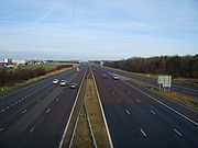
A1(M) motorway
Encyclopedia
England
England is a country that is part of the United Kingdom. It shares land borders with Scotland to the north and Wales to the west; the Irish Sea is to the north west, the Celtic Sea to the south west, with the North Sea to the east and the English Channel to the south separating it from continental...
that upgrades sections of the A1 road that connects London
Greater London
Greater London is the top-level administrative division of England covering London. It was created in 1965 and spans the City of London, including Middle Temple and Inner Temple, and the 32 London boroughs. This territory is coterminate with the London Government Office Region and the London...
, the capital of England and the United Kingdom
United Kingdom
The United Kingdom of Great Britain and Northern IrelandIn the United Kingdom and Dependencies, other languages have been officially recognised as legitimate autochthonous languages under the European Charter for Regional or Minority Languages...
, with Edinburgh
Edinburgh
Edinburgh is the capital city of Scotland, the second largest city in Scotland, and the eighth most populous in the United Kingdom. The City of Edinburgh Council governs one of Scotland's 32 local government council areas. The council area includes urban Edinburgh and a rural area...
, the capital of Scotland
Scotland
Scotland is a country that is part of the United Kingdom. Occupying the northern third of the island of Great Britain, it shares a border with England to the south and is bounded by the North Sea to the east, the Atlantic Ocean to the north and west, and the North Channel and Irish Sea to the...
. The first section, the Doncaster bypass, opened in 1961 and is one of the oldest sections of motorway in Britain.
M25 to Stotfold
This section opened in stages:- Junctions 1 to 2 opened in 1979
- Junctions 2 to 4 opened in 1986
- Junctions 4 to 6 opened in 1973
- Junctions 6 to 8 opened in 1962
- Junctions 8 to 10 opened in 1967
Junctions
| A1(M) Motorway | ||
| Northbound exits | Junction | Southbound exits |
| Stansted Airport (M11, M20) Heathrow, Gatwick (M1, M40, M4, M3,M23) M25 Barnet A1081 Non-motorway traffic |
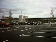
J1 South Mimms services South Mimms services South Mimms services is a motorway service station operated by Welcome Break at the junction of the M25 motorway and the A1 at Bignell's Corner north of London. The siting of the motorway service area has often been criticised, as it is at a heavily congested motorway-motorway intersection. When... |
Road continues as A1 to Central London Central London Central London is the innermost part of London, England. There is no official or commonly accepted definition of its area, but its characteristics are understood to include a high density built environment, high land values, an elevated daytime population and a concentration of regionally,... |
| Start of motorway | Stansted Airport (M11 M11 motorway The M11 motorway in England is a major road running approximately north from the North Circular Road in South Woodford in north-east London to the A14, north-west of Cambridge.-Route:... , M20 M20 motorway The M20 is a motorway in Kent, England. It runs from the M25 motorway to Folkestone, providing a link to the Channel Tunnel and the ports at Dover. It is long... ) Heathrow Gatwick (M1 M1 motorway The M1 is a north–south motorway in England primarily connecting London to Leeds, where it joins the A1 near Aberford. While the M1 is considered to be the first inter-urban motorway to be completed in the United Kingdom, the first road to be built to motorway standard in the country was the... , M40 M40 motorway The M40 motorway is a motorway in the British transport network that forms a major part of the connection between London and Birmingham. Part of this road forms a section of the unsigned European route E05... , M4 M4 motorway The M4 motorway links London with South Wales. It is part of the unsigned European route E30. Other major places directly accessible from M4 junctions are Reading, Swindon, Bristol, Newport, Cardiff and Swansea... , M3, M23) M23 motorway The M23 motorway is a motorway in England. The motorway runs from south of Hooley in Surrey, where it splits from the A23, to Pease Pottage, south of Crawley in West Sussex where it rejoins the A23. The northern end of the motorway starts at junction 7 on what is effectively a spur north from... M25 Barnet Barnet High Barnet or Chipping Barnet is a place in the London Borough of Barnet, North London, England. It is a suburban development built around a twelfth-century settlement and is located north north-west of Charing Cross. Its name is often abbreviated to Barnet, which is also the name of the London... A1081 A1081 road The A1081 road in Hertfordshire, England broadly follows and replaces the former route of the A6 south of Luton in Bedfordshire.It runs from Luton Airport south via Harpenden to St Albans and then bears southeast via London Colney to High Barnet, where it meets the A1000 .The route was renumbered... |
|
| Hatfield Hatfield, Hertfordshire Hatfield is a town and civil parish in Hertfordshire, England in the borough of Welwyn Hatfield. It has a population of 29,616, and is of Saxon origin. Hatfield House, the home of the Marquess of Salisbury, is the nucleus of the old town... A1001 |
J2 | No access |
| St Albans St Albans St Albans is a city in southern Hertfordshire, England, around north of central London, which forms the main urban area of the City and District of St Albans. It is a historic market town, and is now a sought-after dormitory town within the London commuter belt... A414 |
J3 | St Albans St Albans St Albans is a city in southern Hertfordshire, England, around north of central London, which forms the main urban area of the City and District of St Albans. It is a historic market town, and is now a sought-after dormitory town within the London commuter belt... A414 Potters Bar Potters Bar Potters Bar is a town in the Hertsmere borough of Hertfordshire, England, located north of Central London. In 2001 it had a population of 21,618.... A1001 |
| Hatfield Tunnel | ||
| Welwyn Garden City Welwyn Garden City -Economy:Ever since its inception as garden city, Welwyn Garden City has attracted a strong commercial base with several designated employment areas. Among the companies trading in the town are:*Air Link Systems*Baxter*British Lead Mills*Carl Zeiss... , Hertford Hertford Hertford is the county town of Hertfordshire, England, and is also a civil parish in the East Hertfordshire district of the county. Forming a civil parish, the 2001 census put the population of Hertford at about 24,180. Recent estimates are that it is now around 28,000... A414 A414 road The A414 is a major road in England. It runs from the A41 at a junction west of Hemel Hempstead in Hertfordshire, through the town to junction 8 of the M1 motorway at Buncefield, and running parallel to the M1 until junction 7, heading south of St Albans, east through Hatfield, Hertford, then... |
J4 | Welwyn Garden City Welwyn Garden City -Economy:Ever since its inception as garden city, Welwyn Garden City has attracted a strong commercial base with several designated employment areas. Among the companies trading in the town are:*Air Link Systems*Baxter*British Lead Mills*Carl Zeiss... , Hertford Hertford Hertford is the county town of Hertfordshire, England, and is also a civil parish in the East Hertfordshire district of the county. Forming a civil parish, the 2001 census put the population of Hertford at about 24,180. Recent estimates are that it is now around 28,000... A414 |
| No access | J5 | No access |
| Welwyn Welwyn Welwyn is a village and civil parish in Hertfordshire, England. The parish also includes the villages of Digswell and Oaklands. It is sometimes called Old Welwyn to distinguish it from the newer settlement of Welwyn Garden City, about a mile to the south.-History:Situated in the valley of the... , Welwyn Garden City Welwyn Garden City -Economy:Ever since its inception as garden city, Welwyn Garden City has attracted a strong commercial base with several designated employment areas. Among the companies trading in the town are:*Air Link Systems*Baxter*British Lead Mills*Carl Zeiss... A1000 A1000 road The A1000 is a main road in the United Kingdom, running north from Highgate, North London for approximately to Welwyn where it joins the A1 motorway. It incorporates part of the main medieval route out of London, and runs through Finchley, Whetstone, Chipping Barnet and Monken Hadley... |
J6 | Welwyn Welwyn Welwyn is a village and civil parish in Hertfordshire, England. The parish also includes the villages of Digswell and Oaklands. It is sometimes called Old Welwyn to distinguish it from the newer settlement of Welwyn Garden City, about a mile to the south.-History:Situated in the valley of the... , Welwyn Garden City Welwyn Garden City -Economy:Ever since its inception as garden city, Welwyn Garden City has attracted a strong commercial base with several designated employment areas. Among the companies trading in the town are:*Air Link Systems*Baxter*British Lead Mills*Carl Zeiss... A1000 |
| Stevenage Stevenage Stevenage is a town and borough in Hertfordshire, England. It is situated to the east of junctions 7 and 8 of the A1, and is between Letchworth Garden City to the north, and Welwyn Garden City to the south.... , Ware A602 |
J7 | Stevenage Stevenage Stevenage is a town and borough in Hertfordshire, England. It is situated to the east of junctions 7 and 8 of the A1, and is between Letchworth Garden City to the north, and Welwyn Garden City to the south.... , Ware A602 |
| Hitchin Hitchin Hitchin is a town in Hertfordshire, England, with an estimated population of 30,360.-History:Hitchin is first noted as the central place of the Hicce people mentioned in a 7th century document, the Tribal Hidage. The tribal name is Brittonic rather than Old English and derives from *siccā, meaning... , Stevenage Stevenage Stevenage is a town and borough in Hertfordshire, England. It is situated to the east of junctions 7 and 8 of the A1, and is between Letchworth Garden City to the north, and Welwyn Garden City to the south.... A602 A602 road The A602 is a road linking Hitchin in Hertfordshire, England, with A10 at Ware in Hertfordshire, via Stevenage.The course of the road has changed significantly since the 1960s with the construction of several bypasses and relief roads.... |
J8 | Stevenage Stevenage Stevenage is a town and borough in Hertfordshire, England. It is situated to the east of junctions 7 and 8 of the A1, and is between Letchworth Garden City to the north, and Welwyn Garden City to the south.... A602 |
| Letchworth Letchworth Letchworth Garden City, commonly known as Letchworth, is a town and civil parish in Hertfordshire, England. The town's name is taken from one of the three villages it surrounded - all of which featured in the Domesday Book. The land used was first purchased by Quakers who had intended to farm the... , Baldock Baldock Baldock is a historic market town in the local government district of North Hertfordshire in the ceremonial county of Hertfordshire, England where the River Ivel rises. It lies north of London, southeast of Bedford, and north northwest of the county town of Hertford... A505 A505 road The A505 is an A-class road in the United Kingdom. It follows part of the route of the Icknield Way and the corresponding Icknield Way Path.-Bedfordshire:... |
J9 | Letchworth Letchworth Letchworth Garden City, commonly known as Letchworth, is a town and civil parish in Hertfordshire, England. The town's name is taken from one of the three villages it surrounded - all of which featured in the Domesday Book. The land used was first purchased by Quakers who had intended to farm the... , Baldock Baldock Baldock is a historic market town in the local government district of North Hertfordshire in the ceremonial county of Hertfordshire, England where the River Ivel rises. It lies north of London, southeast of Bedford, and north northwest of the county town of Hertford... , Hitchin Hitchin Hitchin is a town in Hertfordshire, England, with an estimated population of 30,360.-History:Hitchin is first noted as the central place of the Hicce people mentioned in a 7th century document, the Tribal Hidage. The tribal name is Brittonic rather than Old English and derives from *siccā, meaning... A505 |
| Stotfold Stotfold Stotfold is a small town and civil parish in the county of Bedfordshire.In the 19th century, Stotfold was regarded as a wealthy place. The saying was that to live in Stotfold, one has to have £100 and a pig. The town is divided by a long road, High Street, which separates the north side from the... , Henlow Henlow Henlow is a village and civil parish in the district of Central Bedfordshire in Bedfordshire, England.RAF Henlow, is located nearby, but is in fact nearer to the village of Stondon... A507 A507 road The A507 is an A-class road in England, linking the M1 motorway near Milton Keynes to the A10 at Buntingford. Beginning at junction 13 of the M1, the road heads east past Ridgmont to Ampthill. Here it passes between Ampthill and its close neighbour Flitwick, essentially separating the two. After... |
J10 Baldock services Baldock services Baldock services is a motorway service station on the A1 motorway near Baldock in Hertfordshire, England. It is operated by Extra. Work on the service area started in March 2000, with the services opening on 22 January 2001... |
Start of Motorway |
| Road continues as A1 to Sandy Sandy, Bedfordshire Sandy is a small market town and civil parish in Bedfordshire, England. It is between Cambridge and Bedford, and on the A1 road from London to Edinburgh. The area is dominated by a range of hills known as the Sand Hills. The River Ivel runs through Sandy. The dedication of the Anglican church is to... |
Stotfold Stotfold Stotfold is a small town and civil parish in the county of Bedfordshire.In the 19th century, Stotfold was regarded as a wealthy place. The saying was that to live in Stotfold, one has to have £100 and a pig. The town is divided by a long road, High Street, which separates the north side from the... , Henlow Henlow Henlow is a village and civil parish in the district of Central Bedfordshire in Bedfordshire, England.RAF Henlow, is located nearby, but is in fact nearer to the village of Stondon... A507 A507 road The A507 is an A-class road in England, linking the M1 motorway near Milton Keynes to the A10 at Buntingford. Beginning at junction 13 of the M1, the road heads east past Ridgmont to Ampthill. Here it passes between Ampthill and its close neighbour Flitwick, essentially separating the two. After... Non-motorway traffic |
|
----
Alconbury to Peterborough
This section opened in 1998.Junctions
| A1(M) Motorway | ||
| Northbound exits | Junction | Southbound exits |
| Alconbury B1043 B roads in Zone 1 of the Great Britain numbering scheme B roads are numbered routes in Great Britain of lesser importance than A roads. See the article Great Britain road numbering scheme for the rationale behind the numbers allocated.-Zone 1 :-Zone 1 :... Non-motorway traffic |
J14 | Road continues as A1 to Sandy |
| Start of Motorway | Alconbury Alconbury Alconbury is a village in the English county of Cambridgeshire.-Geography:It is in the district of Huntingdonshire and gives its name to RAF Alconbury. It is near to the point where a major north/south road, the A1, crosses the only major east/west road: the A14... , Huntingdon Huntingdon Huntingdon is a market town in Cambridgeshire, England. The town was chartered by King John in 1205. It is the traditional county town of Huntingdonshire, and is currently the seat of the Huntingdonshire district council. It is known as the birthplace in 1599 of Oliver Cromwell.-History:Huntingdon... , Cambridge Cambridge The city of Cambridge is a university town and the administrative centre of the county of Cambridgeshire, England. It lies in East Anglia about north of London. Cambridge is at the heart of the high-technology centre known as Silicon Fen – a play on Silicon Valley and the fens surrounding the... , Felixstowe Felixstowe Felixstowe is a seaside town on the North Sea coast of Suffolk, England. The town gives its name to the nearby Port of Felixstowe, which is the largest container port in the United Kingdom and is owned by Hutchinson Ports UK... A14 (M11 M11 motorway The M11 motorway in England is a major road running approximately north from the North Circular Road in South Woodford in north-east London to the A14, north-west of Cambridge.-Route:... ) London THE CITY City of London The City of London is a small area within Greater London, England. It is the historic core of London around which the modern conurbation grew and has held city status since time immemorial. The City’s boundaries have remained almost unchanged since the Middle Ages, and it is now only a tiny part of... and EAST |
|
| Sawtry Sawtry Sawtry is a village in the district of Huntingdonshire in the county of Cambridgeshire, England. The village is home to over people.-Location:... B1043 |
J15 | Sawtry B1043 |
| Yaxley Yaxley, Cambridgeshire Yaxley is a village in the county of Cambridgeshire, England. Historically in Huntingdonshire, it is due south of the city of Peterborough, and is skirted to its west by the A15 road... , Stilton Stilton Stilton is a village in Cambridgeshire, England, and within the historic county boundary of Huntingdonshire.-Geography:Stilton lies south of the city of Peterborough. It lies on the old Great North Road, from London and was an important coaching stop in the days before motorised transport. It... A15 |
J16 | Yaxley, Stilton A15 |
| Peterborough A1139 | J17 Peterborough services |
Start of Motorway |
| Road continues as A1 to Newark | Peterborough A1139 Non-motorway traffic |
|
----
Doncaster bypass
This section opened in 1961 and is one of the oldest sections of motorway in Britain.Junctions
Data from driver location signsDriver location signs
Driver location signs are English highway route markers, first introduced in 2003, that complement distance marker posts. Both types of marker post display the distances from a nominal start point in kilometres...
are used to provide distance and carriageway identifier information.
| A1(M) Motorway | |||
| km | Southbound exits (B Carriageway) | Junction | Northbound exits (A Carriageway) |
| 0.0 | Bawtry A614 Blyth B6045 Non-motorway traffic |
J34 Blyth services |
Road continues as A1 to Newark |
| Start of motorway | Bawtry Bawtry Bawtry is a small market town and civil parish which lies at the point where the Great North Road crosses the River Idle in the Metropolitan Borough of Doncaster in South Yorkshire, England. Nearby towns include Gainsborough to the east, Retford south southeast, Worksop to the southwest and... A614 A614 road The A614 is a main road in England running through the counties of Nottinghamshire, South Yorkshire and the East Riding of Yorkshire.Beginning at Redhill, near Calverton in Nottinghamshire at a roundabout with the A60, the road meets the A6097 at a junction which looks like a roundabout but... Blyth Blyth, Nottinghamshire Blyth is a village in the Bassetlaw district of the county of Nottinghamshire, in the East Midlands, north west of East Retford, on the River Ryton.-Geography:... B6045 |
||
| 12.0 | Sheffield Sheffield Sheffield is a city and metropolitan borough of South Yorkshire, England. Its name derives from the River Sheaf, which runs through the city. Historically a part of the West Riding of Yorkshire, and with some of its southern suburbs annexed from Derbyshire, the city has grown from its largely... , Rotherham Rotherham Rotherham is a town in South Yorkshire, England. It lies on the River Don, at its confluence with the River Rother, between Sheffield and Doncaster. Rotherham, at from Sheffield City Centre, is surrounded by several smaller settlements, which together form the wider Metropolitan Borough of... Hull, Scunthorpe Scunthorpe Scunthorpe is a town within North Lincolnshire, England. It is the administrative centre of the North Lincolnshire unitary authority, and had an estimated total resident population of 72,514 in 2010. A predominantly industrial town, Scunthorpe, the United Kingdom's largest steel processing centre,... , Doncaster Robin Hood Airport M18 |
J35 | Sheffield, Rotherham Hull, Scunthorpe, Robin Hood Airport M18 |
| 14.9 | Doncaster, Doncaster Railport, Conisbrough Conisbrough Conisbrough is a town within the Metropolitan Borough of Doncaster, in South Yorkshire, England. It is located roughly midway between Doncaster and Rotherham, and is built alongside the River Don at... A630 |
J36 | Doncaster, Doncaster Railport, Conisbrough A630 |
| 20.3 | Barnsley Barnsley Barnsley is a town in South Yorkshire, England. It lies on the River Dearne, north of the city of Sheffield, south of Leeds and west of Doncaster. Barnsley is surrounded by several smaller settlements which together form the Metropolitan Borough of Barnsley, of which Barnsley is the largest and... , Thurnscoe Thurnscoe Thurnscoe is a village in the metropolitan borough of Barnsley in South Yorkshire, England. The village is approximately half way between Barnsley and Doncaster, but sufficiently far enough from both to be out of their urban sprawl... A635 A635 road The A635 is a main road that runs between Manchester and Doncaster running east–west through Stalybridge, Saddleworth Moor, Holmfirth and Barnsley.... |
J37 | Barnsley, Thurnscoe A635 |
| 24.4 | South Elmsall, Ackworth, Wakefield A638 | J38 | Start of Motorway |
| Road continues as A1 to Wetherby | South Elmsall South Elmsall South Elmsall pronounced "south em-sull" is a small town and civil parish to the east of Hemsworth in the City of Wakefield in West Yorkshire, England. It is on the B6422 and B6474 .... , Ackworth Ackworth, West Yorkshire Ackworth is a village and civil parish in the metropolitan borough of Wakefield, West Yorkshire, England, situated between Pontefract, Barnsley and Doncaster on the small River Went. The village consists of four parts, High Ackworth, Low Ackworth, Ackworth Moortop, and Brackenhill... , Wakefield Wakefield Wakefield is the main settlement and administrative centre of the City of Wakefield, a metropolitan district of West Yorkshire, England. Located by the River Calder on the eastern edge of the Pennines, the urban area is and had a population of 76,886 in 2001.... A638 A638 road The A638 is a main road in England that runs between the A1 at Markham Moor in Nottinghamshire and Chain Bar Junction 26 of the M62 motorway south of Bradford in West Yorkshire.... Non-motorway traffic |
||
----
Darrington to Dishforth
- Walshford to 49 opened in 1995
- Junctions 43 to 44 opened in 1999
- When this section opened it ended at a temporary terminus south of the M1M1 motorwayThe M1 is a north–south motorway in England primarily connecting London to Leeds, where it joins the A1 near Aberford. While the M1 is considered to be the first inter-urban motorway to be completed in the United Kingdom, the first road to be built to motorway standard in the country was the...
. There was a final exit into Micklefield Village for non-motorway traffic onto what is now the access road. During the first week of June 2009, Junctions 44 and 45 were renumbered to 43 and 44. At the same time the existing A1/A659 Grange Moor junction became A1(M) Junction 45. As a result many atlases show incorrect junction numbering for this stretch of motorway.- Junction 46 to temporary junction at WalshfordWalshfordWalshford is a hamlet in the Harrogate District, in the county of North Yorkshire.- Location :Walshford is located on the A168 road and on the River Nidd.- Nearby settlements :...
opened in 2005 - Junction 40 to south of 43 opened in 2005 & 2006
- Junction 46 to temporary junction at Walshford
- The northern section of the upgrade, bypassing Fairburn village opened to traffic in April 2005 with a temporary connection with the existing A1 between Fairburn and BrothertonBrothertonBrotherton is a village and civil parish in the Selby district of North Yorkshire, England. According to the 2001 census it had a population of 672. The village is on the border with the City of Wakefield and West Yorkshire . Brotherton was on the A1 road two miles north of Knottingley, before...
. The southern section, with a free-flow interchange with the M62 motorwayM62 motorwayThe M62 motorway is a west–east trans-Pennine motorway in Northern England, connecting the cities of Liverpool and Hull via Manchester and Leeds. The road also forms part of the unsigned Euroroutes E20 and E22...
opened to traffic on 13 January 2006.- Junctions 44 to 46 opened in 2009
Junctions
Data from driver location signsDriver location signs
Driver location signs are English highway route markers, first introduced in 2003, that complement distance marker posts. Both types of marker post display the distances from a nominal start point in kilometres...
are used to provide distance and carriageway identifier information.
| A1(M) Motorway | |||
| km | Southbound exits (B Carriageway) | Junction | Northbound exits (A Carriageway) |
| 36.5 | Knottingley Knottingley Knottingley is a town within the metropolitan borough of the City of Wakefield in West Yorkshire, England on the River Aire and the A1 road. It has a population of 13,503.... A162 Non-motorway traffic Ferrybridge services |
J40 | Road continues as A1 to Doncaster |
| Start of motorway | No access | ||
| 41.1 | Hull Kingston upon Hull Kingston upon Hull , usually referred to as Hull, is a city and unitary authority area in the ceremonial county of the East Riding of Yorkshire, England. It stands on the River Hull at its junction with the Humber estuary, 25 miles inland from the North Sea. Hull has a resident population of... , Goole Goole Goole is a town, civil parish and port located approximately inland on the confluence of the rivers Don and Ouse in the East Riding of Yorkshire, England... , Manchester Manchester Manchester is a city and metropolitan borough in Greater Manchester, England. According to the Office for National Statistics, the 2010 mid-year population estimate for Manchester was 498,800. Manchester lies within one of the UK's largest metropolitan areas, the metropolitan county of Greater... , Pontefract Pontefract Pontefract is an historic market town in West Yorkshire, England. Traditionally in the West Riding, near the A1 , the M62 motorway and Castleford. It is one of the five towns in the metropolitan borough of the City of Wakefield and has a population of 28,250... , Leeds M62 M62 motorway The M62 motorway is a west–east trans-Pennine motorway in Northern England, connecting the cities of Liverpool and Hull via Manchester and Leeds. The road also forms part of the unsigned Euroroutes E20 and E22... |
J41 | Hull, Goole, Manchester, Pontefract, Leeds M62 Ferrybridge services |
| 46.7 | Leeds, Selby Selby Selby is a town and civil parish in North Yorkshire, England. Situated south of the city of York, along the course of the River Ouse, Selby is the largest and, with a population of 13,012, most populous settlement of the wider Selby local government district.Historically a part of the West Riding... A63 A63 road The A63 is a major road in Yorkshire, England between Leeds and Hull.-Leeds – Howden:The route out to Selby is shadowed by the Leeds-Selby railway.... |
J42 | Selby A63 |
| No access | J43 | The SOUTH Southern England Southern England, the South and the South of England are imprecise terms used to refer to the southern counties of England bordering the English Midlands. It has a number of different interpretations of its geographic extents. The South is considered by many to be a cultural region with a distinct... , Leeds M1 |
|
| 55.3 | Leeds, York A64 | J44 | Leeds Leeds Leeds is a city and metropolitan borough in West Yorkshire, England. In 2001 Leeds' main urban subdivision had a population of 443,247, while the entire city has a population of 798,800 , making it the 30th-most populous city in the European Union.Leeds is the cultural, financial and commercial... , York York York is a walled city, situated at the confluence of the Rivers Ouse and Foss in North Yorkshire, England. The city has a rich heritage and has provided the backdrop to major political events throughout much of its two millennia of existence... A64 A64 road The A64 is a road in North and West Yorkshire, England which links Leeds, York and Scarborough. The A64 starts as the A64 ring road motorway in Leeds and then is a dual carriageway for the rest of its route, except parts of the road from Malton to Scarborough.The road approximates a section of the... |
| 57.2 | Wetherby, Boston Spa, Otley A659 | J45 | Tadcaster, Boston Spa, Otley A659 |
| Kirk Deighton, Wetherby A168 | J46 Wetherby services Wetherby services Wetherby Services is a major service station north of Wetherby on the A1. The service station fully opened in September 2008. The service station lies on the border between North and West Yorkshire in the north of England... |
Kirk Deighton Kirk Deighton Kirk Deighton is a village and civil parish in the Harrogate district of North Yorkshire, England. It is situated to the immediate north west of Wetherby and near the A1. The village has a population of less than 500 people. Kirk Deighton is set along the county border line between West Yorkshire... , Wetherby A168 |
|
| 79.3 | Knaresborough, Harrogate Harrogate Harrogate is a spa town in North Yorkshire, England. The town is a tourist destination and its visitor attractions include its spa waters, RHS Harlow Carr gardens, and Betty's Tea Rooms. From the town one can explore the nearby Yorkshire Dales national park. Harrogate originated in the 17th... , Leeds Bradford International Airport Leeds Bradford International Airport Leeds Bradford International Airport is located at Yeadon, in the City of Leeds Metropolitan District in West Yorkshire, England, northwest of Leeds city centre itself... A59 A59 road The A59 is a major road in the United Kingdom that runs from Liverpool in Merseyside, to York in North Yorkshire.-Merseyside:The A59 begins in the centre of Liverpool at the mouth of the Birkenhead Tunnel, and heads north out of the city, first as Scotland Road in Vauxhall, then Kirkdale Road,... |
J47 | York, Knaresborough A59 |
| 86.3 | Ripon Ripon Ripon is a cathedral city, market town and successor parish in the Borough of Harrogate, North Yorkshire, England, located at the confluence of two streams of the River Ure in the form of the Laver and Skell. The city is noted for its main feature the Ripon Cathedral which is architecturally... , Boroughbridge Boroughbridge Boroughbridge is a small town and civil parish in the Harrogate district of North Yorkshire, England. It is situated northwest of York. Until its bypass was built, it was on the main A1 road from London to Edinburgh... A168 |
J48 | Boroughbridge A168 Knaresborough Knaresborough Knaresborough is an old and historic market town, spa town and civil parish in the Borough of Harrogate, North Yorkshire, England, located on the River Nidd, four miles east of the centre of Harrogate.-History:... A6055 A6055 road The A6055 is a seven mile stretch of road in North Yorkshire. It runs in a NNE direction from the A59 at Bond End in Knaresborough where it is called Boroughbridge Road, through the Stockwells Estate. It exits Knaresborough just past Greengate Lane where it turns directly north, before once again... |
| 95.2 | Thirsk, Teesside A168 (A19) | J49 | Start of Motorway |
| Road continues as A1 to Scotch Corner | Thirsk Thirsk Thirsk is a small market town and civil parish in the Hambleton district of North Yorkshire, England. The local travel links are located a mile from the town centre to Thirsk railway station and to Durham Tees Valley Airport... , Teesside Teesside Teesside is the name given to the conurbation in the north east of England made up of the towns of Middlesbrough, Stockton-on-Tees, Redcar, Billingham and surrounding settlements near the River Tees. It was also the name of a local government district between 1968 and 1974—the County Borough of... A168 A168 road The A168 is a major road in North Yorkshire, England. It runs from Northallerton to Wetherby, acting as a local access road for the A1.-History:... (A19 A19 road The A19 is a major road in England running approximately parallel to and east of the A1 road, although the two roads meet at the northern end of the A19, the two roads originally met at the southern end of the A19 in Doncaster but the old route of the A1 was changed to the A638. From Sunderland... ) Non-motorway traffic |
||
----
Dishforth to Leeming
Work began in March 2009 to upgrade the Dishforth to Leeming section to dual 3-lane motorway standard with existing connections being replaced by two new junctions. As of July 2010, work was in progress on the Dishforth to Leeming section (J49 to J51) with an estimated completion date in 2012.Junctions
| A1(M) Motorway | ||
| Northbound exits | Junction | Southbound exits |
| Motorway to continue to/from J49 | ||
| Ripon Ripon Ripon is a cathedral city, market town and successor parish in the Borough of Harrogate, North Yorkshire, England, located at the confluence of two streams of the River Ure in the form of the Laver and Skell. The city is noted for its main feature the Ripon Cathedral which is architecturally... , Thirsk Thirsk Thirsk is a small market town and civil parish in the Hambleton district of North Yorkshire, England. The local travel links are located a mile from the town centre to Thirsk railway station and to Durham Tees Valley Airport... A61 A61 road The A61 is a major trunk road in England. It runs from Derby to Thirsk in North Yorkshire. From Derby, it heads north via Alfreton, Clay Cross, Chesterfield, Sheffield, Barnsley, Wakefield, Leeds, Harrogate and Ripon... |
J50 (under construction) |
Ripon, Harrogate, Thirsk A61 |
| Northallerton Northallerton Northallerton is an affluent market town and civil parish in the Hambleton district of North Yorkshire, England. It lies in the Vale of Mowbray and at the northern end of the Vale of York. It has a population of 15,741 according to the 2001 census... , Leeming Bar Leeming Bar Leeming Bar is a village in the Hambleton district of North Yorkshire, England.-Geography:Located next to the A1 and near RAF Leeming it is home to the main depot and current terminus of the Wensleydale Railway at Leeming Bar railway station as well as the Dales & District bus company. It was... , Bedale Bedale Bedale is a market town and civil parish in the district of Hambleton, North Yorkshire, England. It lies north of Leeds, southwest of Middlesbrough, and south west of the county town of Northallerton... A684 A684 road The A684 is an A road that runs through Cumbria and North Yorkshire, starting at Kendal, Cumbria and ending at Ellerbeck and the A19 road in North Yorkshire... |
J51 (under construction) |
Start of Motorway |
| Road continues as A1 to Scotch Corner | Northallerton, Leeming Bar, Bedale A684 Non-motorway traffic |
|
----
Scotch Corner to Gateshead
This section opened in stages:- Junctions 56 to 59 opened in 1965
- Junctions 59 to 63 opened in 1969
- Junctions 63 to 65 opened in 1970
Junctions
| A1(M) Motorway | ||
| Northbound exits | Junction | Southbound exits |
| Melsonby, Barton B6275 Non-motorway traffic |
J56 | Road continues as A1 towards Wetherby |
| Start of Motorway | Piercebridge Piercebridge Piercebridge is a village and civil parish in the borough of Darlington and the ceremonial county of Durham, England. It is situated a few miles west of the town of Darlington. It is on the site of a Roman fort of AD 260-270, which was built at the point where Dere Street crossed the River Tees.... B6275, Barton Barton, North Yorkshire Barton is a village and civil parish in the Richmondshire district of North Yorkshire, England. According to the 2001 census it had a population of 884. It is situated near the border with the ceremonial county of County Durham, and is 6 miles south-west of Darlington. The village is recorded as... Non-motorway traffic to Darlington |
|
| Darlington Darlington Darlington is a market town in the Borough of Darlington, part of the ceremonial county of County Durham, England. It lies on the small River Skerne, a tributary of the River Tees, not far from the main river. It is the main population centre in the borough, with a population of 97,838 as of 2001... , Teesside Teesside Teesside is the name given to the conurbation in the north east of England made up of the towns of Middlesbrough, Stockton-on-Tees, Redcar, Billingham and surrounding settlements near the River Tees. It was also the name of a local government district between 1968 and 1974—the County Borough of... & Airport A66(M) A66 road The A66 is a major road in northern England which in part follows the course of the Roman road from Scotch Corner to Penrith. It runs from east of Middlesbrough in the ceremonial county of North Yorkshire to Workington in Cumbria... |
J57 | No access |
| Darlington Darlington Darlington is a market town in the Borough of Darlington, part of the ceremonial county of County Durham, England. It lies on the small River Skerne, a tributary of the River Tees, not far from the main river. It is the main population centre in the borough, with a population of 97,838 as of 2001... , Bishop Auckland Bishop Auckland Bishop Auckland is a market town and civil parish in County Durham in north east England. It is located about northwest of Darlington and southwest of Durham at the confluence of the River Wear with its tributary the River Gaunless... , Corbridge Corbridge Corbridge is a village in Northumberland, England, situated west of Newcastle and east of Hexham. Villages in the vicinity include Halton, Acomb, Aydon and Sandhoe.-Roman fort and town:... A68 A68 road The A68 is a major road in the United Kingdom, running from Darlington in England to the A720 in Scotland.From Darlington, the road runs north, bypassing Bishop Auckland, and running through West Auckland, Toft Hill and Tow Law, past Consett and Corbridge... |
J58 | Darlington A68 |
| Newton Aycliffe A167 A167 road The A167 is a road in North East England. Most of its route was formerly the A1 as most of it is the original route of the Great North Road until the A1 was re-routed with the opening of the A1 in the 1960s.... |
J59 | Newton Aycliffe, Darlington, Teesside Airport A167 |
| Hartlepool Hartlepool Hartlepool is a town and port in North East England.It was founded in the 7th century AD, around the Northumbrian monastery of Hartlepool Abbey. The village grew during the Middle Ages and developed a harbour which served as the official port of the County Palatine of Durham. A railway link from... , Bishop Auckland Bishop Auckland Bishop Auckland is a market town and civil parish in County Durham in north east England. It is located about northwest of Darlington and southwest of Durham at the confluence of the River Wear with its tributary the River Gaunless... , Teesside Teesside Teesside is the name given to the conurbation in the north east of England made up of the towns of Middlesbrough, Stockton-on-Tees, Redcar, Billingham and surrounding settlements near the River Tees. It was also the name of a local government district between 1968 and 1974—the County Borough of... A689 A689 road The A689 is a road in northern England, that runs east from Junction 44 of the M6 motorway, north of the centre of Carlisle in Cumbria, to Hartlepool, in the North East.... |
J60 | Hartlepool Hartlepool Hartlepool is a town and port in North East England.It was founded in the 7th century AD, around the Northumbrian monastery of Hartlepool Abbey. The village grew during the Middle Ages and developed a harbour which served as the official port of the County Palatine of Durham. A railway link from... , Bishop Auckland Bishop Auckland Bishop Auckland is a market town and civil parish in County Durham in north east England. It is located about northwest of Darlington and southwest of Durham at the confluence of the River Wear with its tributary the River Gaunless... , Teesside Teesside Teesside is the name given to the conurbation in the north east of England made up of the towns of Middlesbrough, Stockton-on-Tees, Redcar, Billingham and surrounding settlements near the River Tees. It was also the name of a local government district between 1968 and 1974—the County Borough of... A689 A689 road The A689 is a road in northern England, that runs east from Junction 44 of the M6 motorway, north of the centre of Carlisle in Cumbria, to Hartlepool, in the North East.... |
| Spennymoor Spennymoor Spennymoor is a town in County Durham, England. It stands above the Wear Valley approximately seven miles south of Durham. The town was founded over 160 years ago... A688 A688 road The A688 is a road in County Durham in North East England.It begins at the junction with the A67 road in Barnard Castle and continues in a north easterly direction for , terminating at the A181 to the east of Durham City.... Durham A177 |
J61 Durham services Durham Services Durham Motorway Services are Located at junction 61 on the A1 . Located six miles from Durham City in between the villages of Bowburn and Coxhoe in County Durham. Opened in 1994 by David Bellamy.- External links :* *... |
Bishop Auckland Bishop Auckland Bishop Auckland is a market town and civil parish in County Durham in north east England. It is located about northwest of Darlington and southwest of Durham at the confluence of the River Wear with its tributary the River Gaunless... , Spennymoor A688 |
| Durham, Sunderland A690 A690 road The A690 is a road in County Durham running from Sunderland in the east through Durham to Crook.-Sunderland section:Throughout the Sunderland section it is known as either Durham Road or New Durham Road, and is one of the major routes in and out of the city. A single carriageway section runs from... |
J62 | Durham A690 |
| Chester-le-Street Chester-le-Street Chester-le-Street is a town in County Durham, England. It has a history going back to Roman times when it was called Concangis. The town is located south of Newcastle upon Tyne and west of Sunderland on the River Wear... A167 A167 road The A167 is a road in North East England. Most of its route was formerly the A1 as most of it is the original route of the Great North Road until the A1 was re-routed with the opening of the A1 in the 1960s.... Stanley Stanley, County Durham Stanley is a former colliery town and civil parish in County Durham, England. Centred on a hilltop between Chester-le-Street and Consett, the town lies south west of Gateshead.... A693 |
J63 | Chester-le-Street A167 Stanley A693 |
| Washington A195 | J64 | Washington A195 |
| Washington services | ||
| South Shields South Shields South Shields is a coastal town in Tyne and Wear, England, located at the mouth of the River Tyne to Tyne Dock, and about downstream from Newcastle upon Tyne... , Tyne Tunnel Tyne Tunnel The Tyne Tunnel is a the name given to two two-lane toll vehicular tunnels under the River Tyne in North East England. Completed in 1967 and 2011 respectively, they connect the town of Jarrow on the south bank of the river with North Shields and Howdon on the north... A194(M) |
J65 | Start of Motorway |
| Road continues as A1 to Edinburgh | Sunderland A1231 A1231 road The A1231 road runs between Sunderland and Washington in Tyne and Wear, North East England. It is the main road joining Sunderland and Washington and is one of the main trunk roads leading in and out of Sunderland city centre... Non-motorway traffic |
|