

London Wall
Encyclopedia
Defensive wall
A defensive wall is a fortification used to protect a city or settlement from potential aggressors. In ancient to modern times, they were used to enclose settlements...
first built by the Roman
Ancient Rome
Ancient Rome was a thriving civilization that grew on the Italian Peninsula as early as the 8th century BC. Located along the Mediterranean Sea and centered on the city of Rome, it expanded to one of the largest empires in the ancient world....
s around Londinium, their strategically important port town on the River Thames
River Thames
The River Thames flows through southern England. It is the longest river entirely in England and the second longest in the United Kingdom. While it is best known because its lower reaches flow through central London, the river flows alongside several other towns and cities, including Oxford,...
in what is now the United Kingdom
United Kingdom
The United Kingdom of Great Britain and Northern IrelandIn the United Kingdom and Dependencies, other languages have been officially recognised as legitimate autochthonous languages under the European Charter for Regional or Minority Languages...
, and subsequently maintained until the 18th century. It is now the name of a road in the City of London
City of London
The City of London is a small area within Greater London, England. It is the historic core of London around which the modern conurbation grew and has held city status since time immemorial. The City’s boundaries have remained almost unchanged since the Middle Ages, and it is now only a tiny part of...
running along part of the course of the wall. Until the later Middle Ages the wall defined the boundaries of the City of London.
Construction of the Roman wall
The wall appears to have been built in the late 2nd or early 3rd century, certainly between 190 and 225, and probably between 200 and 220. This was around 80 years after the construction in 120 of the city's fort, whose north and west walls were thickened and doubled in height to form part of the new city wall. It continued to be developed until at least the end of the 4th century, making it among the last major building projects undertaken by the RomansRoman Britain
Roman Britain was the part of the island of Great Britain controlled by the Roman Empire from AD 43 until ca. AD 410.The Romans referred to the imperial province as Britannia, which eventually comprised all of the island of Great Britain south of the fluid frontier with Caledonia...
before the Roman departure from Britain in 410.
Although the exact reason for the wall's construction is unknown, it may have been connected to the invasion of northern Britain by Picts
Picts
The Picts were a group of Late Iron Age and Early Mediaeval people living in what is now eastern and northern Scotland. There is an association with the distribution of brochs, place names beginning 'Pit-', for instance Pitlochry, and Pictish stones. They are recorded from before the Roman conquest...
who overran Hadrian's Wall
Hadrian's Wall
Hadrian's Wall was a defensive fortification in Roman Britain. Begun in AD 122, during the rule of emperor Hadrian, it was the first of two fortifications built across Great Britain, the second being the Antonine Wall, lesser known of the two because its physical remains are less evident today.The...
in the 180s.
Alternatively, many historians link the building of London Wall with the political crisis that had emerged in the 190s when two men—Septimius Severus
Septimius Severus
Septimius Severus , also known as Severus, was Roman Emperor from 193 to 211. Severus was born in Leptis Magna in the province of Africa. As a young man he advanced through the customary succession of offices under the reigns of Marcus Aurelius and Commodus. Severus seized power after the death of...
, and the governor of Britain Clodius Albinus
Clodius Albinus
Clodius Albinus was a Roman usurper proclaimed emperor by the legions in Britain and Hispania upon the murder of Pertinax in 193.-Life:...
—both claimed the right to succession as Emperor. The wall may have been constructed on the orders of Albinus in the 190s, who, in a power struggle with his rival, may have felt the need to protect his capital. Septimius eventually defeated his rival in 197.
Along with Hadrian's Wall and the road network, the London Wall was one of the largest construction projects carried out in Roman Britain. The wall was constructed largely from Kent
Kent
Kent is a county in southeast England, and is one of the home counties. It borders East Sussex, Surrey and Greater London and has a defined boundary with Essex in the middle of the Thames Estuary. The ceremonial county boundaries of Kent include the shire county of Kent and the unitary borough of...
ish ragstone brought by water from Maidstone
Maidstone
Maidstone is the county town of Kent, England, south-east of London. The River Medway runs through the centre of the town linking Maidstone to Rochester and the Thames Estuary. Historically, the river was a source and route for much of the town's trade. Maidstone was the centre of the agricultural...
. It has been calculated that some 1,300 barge journeys would have been required to transport the 85,000 ton
Ton
The ton is a unit of measure. It has a long history and has acquired a number of meanings and uses over the years. It is used principally as a unit of weight, and as a unit of volume. It can also be used as a measure of energy, for truck classification, or as a colloquial term.It is derived from...
s of stone from Kent. Once built, the wall was nearly 3 miles (5 kilometres) long, enclosed an area of about 330 acres (133.5 ha), and was 6 to 9 feet (2 to 3 m) wide and about 20 feet (6 m) high. It had a ditch or fossa in front of the outer wall, measuring some 6 feet (2 m) deep by between 9 and 15 feet (3 to 5 m) wide. It included a number of bastion
Bastion
A bastion, or a bulwark, is a structure projecting outward from the main enclosure of a fortification, situated in both corners of a straight wall , facilitating active defence against assaulting troops...
s (at least twenty-two) spaced about 70 yards (64 m) apart, on the eastern section of the wall.
The economic stimulus provided by the wall and Septimius's campaigns of conquest in Scotland
Scotland
Scotland is a country that is part of the United Kingdom. Occupying the northern third of the island of Great Britain, it shares a border with England to the south and is bounded by the North Sea to the east, the Atlantic Ocean to the north and west, and the North Channel and Irish Sea to the...
appear to have revived Londinium's fortunes somewhat in the early third century.
Gates
The wall had a number of gates around the outside that led to important Roman roadRoman road
The Roman roads were a vital part of the development of the Roman state, from about 500 BC through the expansion during the Roman Republic and the Roman Empire. Roman roads enabled the Romans to move armies and trade goods and to communicate. The Roman road system spanned more than 400,000 km...
s, leading to other towns in the country. The gates on the wall going clockwise from Ludgate in the west to Aldgate in the east were: Ludgate
Ludgate
Ludgate was the westernmost gate in London Wall. The name survives in Ludgate Hill, an eastward continuation of Fleet Street, and Ludgate Circus.-Etymology:...
, Newgate
Newgate
Newgate at the west end of Newgate Street was one of the historic seven gates of London Wall round the City of London and one of the six which date back to Roman times. From it a Roman road led west to Silchester...
, Cripplegate
Cripplegate
Cripplegate was a city gate in the London Wall and a name for the region of the City of London outside the gate. The area was almost entirely destroyed by bombing in World War II and today is the site of the Barbican Estate and Barbican Centre...
, Bishopsgate
Bishopsgate
Bishopsgate is a road and ward in the northeast part of the City of London, extending north from Gracechurch Street to Norton Folgate. It is named after one of the original seven gates in London Wall...
and Aldgate
Aldgate
Aldgate was the eastern most gateway through London Wall leading from the City of London to Whitechapel and the east end of London. Aldgate gives its name to a ward of the City...
. Aldersgate
Aldersgate
Aldersgate was a gate in the London Wall in the City of London, which has given its name to a ward and Aldersgate Street, a road leading north from the site of the gate, towards Clerkenwell in the London Borough of Islington.-History:...
, between Newgate and Cripplegate, was added c. 350, and Moorgate
Moorgate
Moorgate was a postern in the London Wall originally built by the Romans. It was turned into a gate in the 15th century. Though the gate was demolished in 1762, the name survives as a major street in the City of London...
, between Cripplegate and Bishopsgate, was built later still, in the medieval period. These bring the number of gates up to the canonical seven, commemorated in London tradition and literature. Some of the gates, though now long gone, are remembered by the areas or roads where the gates stood being named after them. Due to the rapid growth of the city, the number of gates was increased to cope with the extra traffic in the medieval period, and the walls were also strengthened and built upon.
The boundaries of the City of London ceased to coincide with the old city wall as the City expanded its jurisdiction slightly during the medieval era. The City's jurisdiction expanded westwards, crossing the historic western border of the original settlement - the River Fleet
River Fleet
The River Fleet is the largest of London's subterranean rivers. Its two headwaters are two streams on Hampstead Heath; each is now dammed into a series of ponds made in the 18th century, the Hampstead Ponds and the Highgate Ponds. At the south edge of Hampstead Heath these two streams flow...
- along Fleet Street
Fleet Street
Fleet Street is a street in central London, United Kingdom, named after the River Fleet, a stream that now flows underground. It was the home of the British press until the 1980s...
to Temple Bar
Temple Bar, London
Temple Bar is the barrier marking the westernmost extent of the City of London on the road to Westminster, where Fleet Street becomes the Strand...
. The City also took in the other "City bars" which were situated just beyond the old walled area, such as at Holborn, Aldersgate, Bishopsgate and Aldgate. These were the important entrances to the City and their control was vital in maintaining the City's special privileges over certain trades.
Riverside Wall
In the late third century, Londinium was raided on several occasions by SaxonSaxons
The Saxons were a confederation of Germanic tribes originating on the North German plain. The Saxons earliest known area of settlement is Northern Albingia, an area approximately that of modern Holstein...
pirates. This led, from around 280 onwards, to the construction of an additional riverside wall.
Later use and remains
The wall remained in active use as a fortification for over 1,000 years afterwards. It was used to defend London against raiding Saxons in 457, and was redeveloped in the medieval period with the addition of crenellations, more gates and further bastions. It was not until as late as the 18th and 19th centuries that the wall underwent substantial demolition, though even then large portions of it survived by being incorporated into other structures. Amid the devastation of the BlitzThe Blitz
The Blitz was the sustained strategic bombing of Britain by Nazi Germany between 7 September 1940 and 10 May 1941, during the Second World War. The city of London was bombed by the Luftwaffe for 76 consecutive nights and many towns and cities across the country followed...
, some of the tallest ruins in the bomb-damaged City were remnants of the Roman wall.
The wall's moat has also left its mark on London; it forms the line of the street of Houndsditch
Houndsditch
Houndsditch is a street in the City of London that connects Bishopsgate in the north west to Aldgate in the south east. The modern street runs through a part of the Portsoken Ward and Bishopsgate Ward Without...
. This was once London's main rubbish disposal site and was notorious for its appalling odour; its name, according to the 16th century historian John Stow
John Stow
John Stow was an English historian and antiquarian.-Early life:The son of Thomas Stow, a tallow-chandler, he was born about 1525 in London, in the parish of St Michael, Cornhill. His father's whole rent for his house and garden was only 6s. 6d. a year, and Stow in his youth fetched milk every...
, was derived "from that in old time, when the same lay open, much filth (conveyed forth of the City) especially dead dogges were there laid or cast." The moat was finally covered over and filled in at the end of the 16th century, becoming the present street.
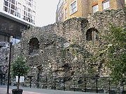
Today all that remains of the wall are a few (albeit substantial) fragments, some of which can be seen in the grounds of the Museum of London
Museum of London
The Museum of London documents the history of London from the Prehistoric to the present day. The museum is located close to the Barbican Centre, as part of the striking Barbican complex of buildings created in the 1960s and 70s as an innovative approach to re-development within a bomb damaged...
, in the Barbican Estate
Barbican Estate
The Barbican Estate is a residential estate built during the 1960s and the 1970s in the City of London, in an area once devastated by World War II bombings and today densely populated by financial institutions...
and around Tower Hill. A section near the Museum of London
Museum of London
The Museum of London documents the history of London from the Prehistoric to the present day. The museum is located close to the Barbican Centre, as part of the striking Barbican complex of buildings created in the 1960s and 70s as an innovative approach to re-development within a bomb damaged...
was revealed at Noble Street, after the devastation of an air raid on 29 December 1940 at the height of the Blitz
The Blitz
The Blitz was the sustained strategic bombing of Britain by Nazi Germany between 7 September 1940 and 10 May 1941, during the Second World War. The city of London was bombed by the Luftwaffe for 76 consecutive nights and many towns and cities across the country followed...
. Another visible section is at St Alphage Gardens
St Alphage London Wall
St Alphage London Wall, so called because it sat right on London Wall, the City of London boundary, was a church in Bassishaw Ward in the City of London...
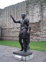
, and other sections form part of the walls or foundations of modern buildings and are only visible from inside those buildings. One of the largest and most readily accessed fragments of the wall stands just outside Tower Hill tube station
Tower Hill tube station
Tower Hill is a London Underground station at Tower Hill in the London Borough of Tower Hamlets.The station is in Travelcard Zone 1 and near the Tower of London...
, with a replica statue of the Emperor Trajan standing in front of it.
In 1984 the Museum of London set up a Wall Walk from the Tower of London to the Museum, using 23 tiled panels. A number of these have been destroyed in subsequent years. At Noble Street, the panels were replaced by etched glass panels. These were intended as a prototype for new panels along the entire walk, but no further replacements have been made.
The modern road
Part of the route originally taken by the northern wall is commemorated, although now only loosely followed, by the road also named London Wall, on which the Museum of London is located. The modern road starts in the west with a roundabout at AldersgateAldersgate
Aldersgate was a gate in the London Wall in the City of London, which has given its name to a ward and Aldersgate Street, a road leading north from the site of the gate, towards Clerkenwell in the London Borough of Islington.-History:...
, then passes east past Moorgate
Moorgate
Moorgate was a postern in the London Wall originally built by the Romans. It was turned into a gate in the 15th century. Though the gate was demolished in 1762, the name survives as a major street in the City of London...
, from which point it runs parallel to the line of the City Wall, and eventually becomes Wormwood Street
Wormwood Street
Wormwood Street is a street in the City of London which connects the London Wall thoroughfare with Bishopsgate. The name refers to a plant called wormwood which used to grow on London Wall and in other areas of waste land in the City...
before it reaches Bishopsgate
Bishopsgate
Bishopsgate is a road and ward in the northeast part of the City of London, extending north from Gracechurch Street to Norton Folgate. It is named after one of the original seven gates in London Wall...
. This alignment, however, is the result of rebuilding between 1957 and 1976. Prior to this, London Wall was less wide, and ran behind the line of the City Wall for its entire length, from Wormwood Street to Wood Street. The western section is now St Alphage Garden.
| Location | Coordinates |
|---|---|
| Museum of London | 51°31′03"N 0°05′49"W |
| Barbican | 51°31′08"N 0°05′35"W |
| London Wall | 51°31′04"N 0°05′43"W |
| St Alphage Garden St Alphage London Wall St Alphage London Wall, so called because it sat right on London Wall, the City of London boundary, was a church in Bassishaw Ward in the City of London... |
51°31′05"N 0°05′33"W |
| Cooper's Row | 51°30′38"N 0°04′34"W |
| Tower Hill | 51°30′36"N 0°04′33"W |
Within and Without the Wall
The suffix words "Without" and "Within" denote whether an area of the CityCity of London
The City of London is a small area within Greater London, England. It is the historic core of London around which the modern conurbation grew and has held city status since time immemorial. The City’s boundaries have remained almost unchanged since the Middle Ages, and it is now only a tiny part of...
— and usually applied to the wards
Wards of the City of London
The City of London , in the United Kingdom, is constituted of 25 wards. The City is the historic core of the much wider metropolis of London, with an ancient and sui generis form of local government, which avoided the many reforms enacted to local government elsewhere in the country in the 19th and...
— fell outside or within the London Wall, though only Farringdon and (formerly) Bridge
Bridge (ward)
Bridge is a small ward of the City of London and is named from its propinquity to London Bridge. Bridge ward is found within the boundary formed by the River Thames, Swan Lane, Arthur Street, Fish Street Hill, Gracechurch Street, Fenchurch Street, Rood Lane, Lovat Lane and Lower Thames Street.The...
have been split into separate wards this way (Bridge Without falling beyond the gates on London Bridge
London Bridge
London Bridge is a bridge over the River Thames, connecting the City of London and Southwark, in central London. Situated between Cannon Street Railway Bridge and Tower Bridge, it forms the western end of the Pool of London...
). Some wards — Aldersgate
Aldersgate
Aldersgate was a gate in the London Wall in the City of London, which has given its name to a ward and Aldersgate Street, a road leading north from the site of the gate, towards Clerkenwell in the London Borough of Islington.-History:...
, Bishopsgate
Bishopsgate
Bishopsgate is a road and ward in the northeast part of the City of London, extending north from Gracechurch Street to Norton Folgate. It is named after one of the original seven gates in London Wall...
and Cripplegate
Cripplegate
Cripplegate was a city gate in the London Wall and a name for the region of the City of London outside the gate. The area was almost entirely destroyed by bombing in World War II and today is the site of the Barbican Estate and Barbican Centre...
— cover an area that was both within and outwith the Wall and, although not split into separate wards, often the part (or "division") within the Wall is denoted (on maps, in documents, etc) as being "Within" and the part outside the Wall as being "Without". Archaically "Infra" (within) and "Extra" (without) were also used and the terms "intramural" and "extramural" are also used to describe being within or outside the walled part of the City.
See also
- Roman London
- Fortifications of LondonFortifications of LondonThe fortifications of London are extensive and mostly well maintained, though many of the City of London's fortifications and defences were dismantled in the 17th and 18th century...
- List of cities with defensive walls
- List of town walls in England and Wales
- York city wallsYork city wallsThe English city of York has, since Roman times, been defended by walls of one form or another. To this day, substantial portions of the walls remain, and York has more miles of intact wall than any other city in England...
- Chester city wallsChester city walls.Chester city walls consist of a defensive structure built to protect the city of Chester in Cheshire, England. Their construction was started by the Romans when they established the fortress of Deva Victrix between 70 and 80 AD. It originated with a rampart of earth and turf surmounted by a...