

Waterfalls in Ricketts Glen State Park
Encyclopedia
Image map
In HTML and XHTML , an image map is a list of coordinates relating to a specific image, created in order to hyperlink areas of the image to various destinations . For example, a map of the world may have each country hyperlinked to further information about that country...
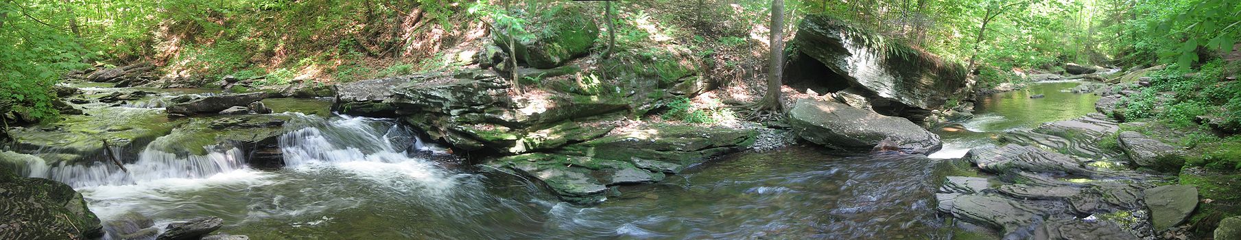
of Kitchen Creek and its waterfalls in Ricketts Glen State Park, as well as other prominent features. Each label is linked to an article or image. Click on small rectangles in the caption for larger map.
rect 23 473 109 508 Sullivan County, Pennsylvania
Sullivan County, Pennsylvania
Sullivan County is a county located in the U.S. state of Pennsylvania. As of 2010, the population is 6,428. Sullivan County was created on March 15, 1847, from part of Lycoming County and named for Charles Sullivan, leader of the Pennsylvania Senate...
rect 1 631 88 667 Columbia County, Pennsylvania
Columbia County, Pennsylvania
As of the census of 2000, there were 64,151 people, 24,915 households, and 16,568 families residing in the county. The population density was 132 people per square mile . There were 27,733 housing units at an average density of 57 per square mile...
rect 121 562 206 601 Luzerne County, Pennsylvania
Luzerne County, Pennsylvania
- Demographics :As of the 2010 census, the county was 90.7% White, 3.4% Black or African American, 0.2% Native American, 1.0% Asian, 3.3% were of some other race, and 1.5% were two or more races. 6.7% of the population was of Hispanic or Latino ancestry...
rect 182 454 240 512 Pennsylvania Route 487
Pennsylvania Route 487
Pennsylvania Route 487 is a long, north–south state highway running from PA 61 in Shamokin Township, Northumberland County to PA 87 in Dushore, Sullivan County. In Bloomsburg, PA 487 and US 11 share a brief wrong-way concurrency...
rect 674 670 792 692 Pennsylvania Route 118
Pennsylvania Route 118
Route 118 is a long state route located in northeastern Pennsylvania. The western terminus of the route is at PA 405 in Hughesville. The eastern terminus is at PA 415 in Dallas...
rect 471 596 543 632 Ricketts Glen
rect 655 280 780 319 Bowman Creek
Bowman Creek
Bowman Creek is a tributary of the Susquehanna River in northeast Pennsylvania in the United States.Bowman Creek joins the Susquehanna River just downstream of the borough of Tunkhannock.-References:...
rect 505 6 646 41 Ricketts Glen State Park
Ricketts Glen State Park
Ricketts Glen State Park is a Pennsylvania state park on in Columbia, Luzerne, and Sullivan counties in Pennsylvania in the United States. Ricketts Glen is a National Natural Landmark known for its old-growth forest and 24 named waterfalls along Kitchen Creek, which flows down the Allegheny...
rect 477 651 543 690 Kitchen Creek
Kitchen Creek (Pennsylvania)
Kitchen Creek is a tributary of Huntington Creek in Fairmount and Huntington townships in Luzerne County in the U.S. state of Pennsylvania.It is best known as the main stream flowing through Ricketts Glen State Park and has 24 named waterfalls within the park. Kitchen Creek is in the larger...
rect 494 750 551 770 Adams Falls
rect 366 733 485 753 Kitchen Creek Falls
rect 499 546 618 563 Shingle Cabin Falls
rect 491 488 632 506 Murray Reynolds Falls
rect 487 471 631 488 Sheldon Reynolds Falls
rect 480 454 615 470 Harrison Wright Falls
rect 413 398 469 437 Waters Meet
rect 447 298 494 334 Glen Leigh
rect 478 428 556 445 Wyandot Falls
rect 483 410 585 427 B. Reynolds Falls
rect 485 392 595 408 R. B. Ricketts Falls
rect 483 376 539 391 Ozone Falls
rect 491 348 545 365 Huron Falls
rect 496 326 573 345 Shawnee Falls
rect 498 306 604 323 F.L. Ricketts Falls
rect 500 287 585 304 Onondaga Falls
rect 356 355 421 389 Ganoga Glen
rect 427 521 463 538 Erie Falls
rect 362 503 447 519
rect 325 487 415 503 Conestoga Falls
rect 321 472 394 488 Mohican Falls
rect 285 452 367 470 Delaware Falls
rect 312 434 377 450 Seneca Falls
rect 308 418 373 434 Ganoga Falls
rect 286 398 349 414 Cayuga Falls
rect 276 383 337 398 Oneida Falls
rect 248 365 321 382 Mohawk Falls
rect 540 520 705 540 Shingle Cabin Brook
Kitchen Creek (Pennsylvania)
Kitchen Creek is a tributary of Huntington Creek in Fairmount and Huntington townships in Luzerne County in the U.S. state of Pennsylvania.It is best known as the main stream flowing through Ricketts Glen State Park and has 24 named waterfalls within the park. Kitchen Creek is in the larger...
rect 306 116 352 156 Lake Jean
rect 253 295 344 340 Lake Rose
rect 564 165 614 209 Lake Leigh
rect 4 234 78 259 Big Run (Fishing Creek tributary)
Fishing Creek (North Branch Susquehanna River)
Fishing Creek is a tributary of the Susquehanna River in Columbia County, Pennsylvania, in the United States.Fishing Creek joins the Susquehanna River near the village of Rupert, just southwest of the town of Bloomsburg.-Tributaries:travelling upstream...
rect 63 0 130 35 Ganoga Lake
Ganoga Lake
Ganoga Lake is a natural lake in Colley Township in southeast Sullivan County in Pennsylvania, United States. Known as Robinson's Lake and Long Pond for most of the 19th century, the lake was purchased by the Ricketts family in the early 1850s and became part of R. Bruce Ricketts' extensive...
desc bottom-left
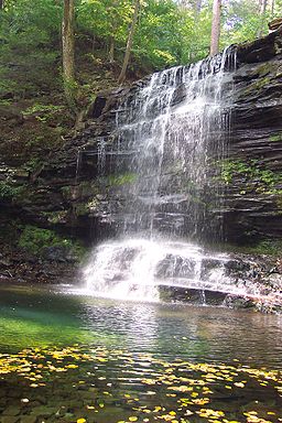
There are 24 named waterfalls in Ricketts Glen State Park in the U.S. state
U.S. state
A U.S. state is any one of the 50 federated states of the United States of America that share sovereignty with the federal government. Because of this shared sovereignty, an American is a citizen both of the federal entity and of his or her state of domicile. Four states use the official title of...
of Pennsylvania
Pennsylvania
The Commonwealth of Pennsylvania is a U.S. state that is located in the Northeastern and Mid-Atlantic regions of the United States. The state borders Delaware and Maryland to the south, West Virginia to the southwest, Ohio to the west, New York and Ontario, Canada, to the north, and New Jersey to...
, ranging in height from 9 to 94 feet (2.7 to 29 m), along Kitchen Creek
Kitchen Creek (Pennsylvania)
Kitchen Creek is a tributary of Huntington Creek in Fairmount and Huntington townships in Luzerne County in the U.S. state of Pennsylvania.It is best known as the main stream flowing through Ricketts Glen State Park and has 24 named waterfalls within the park. Kitchen Creek is in the larger...
as it flows in three steep, narrow valleys, or glen
Glen
A glen is a valley, typically one that is long, deep, and often glacially U-shaped; or one with a watercourse running through such a valley. Whittow defines it as a "Scottish term for a deep valley in the Highlands" that is "narrower than a strath."...
s. Ricketts Glen State Park
Ricketts Glen State Park
Ricketts Glen State Park is a Pennsylvania state park on in Columbia, Luzerne, and Sullivan counties in Pennsylvania in the United States. Ricketts Glen is a National Natural Landmark known for its old-growth forest and 24 named waterfalls along Kitchen Creek, which flows down the Allegheny...
is named for R. Bruce Ricketts
R. Bruce Ricketts
Robert Bruce Ricketts distinguished himself as an artillery officer in the American Civil War. He is best known for his battery’s defense against a Confederate attack on Cemetery Hill on the second day of the Battle of Gettysburg.-Early life:...
, a colonel in the American Civil War
American Civil War
The American Civil War was a civil war fought in the United States of America. In response to the election of Abraham Lincoln as President of the United States, 11 southern slave states declared their secession from the United States and formed the Confederate States of America ; the other 25...
who owned over 80,000 acres (32,000 ha) in the area in the late 19th and early 20th centuries, but spared the old growth forest
Old growth forest
An old-growth forest is a forest that has attained great age , and thereby exhibits unique ecological features. An old growth forest has also usually reached a climax community...
s in the glens from clearcutting
Clearcutting
Clearcutting, or clearfelling, is a controversial forestry/logging practice in which most or all trees in an area are uniformly cut down. Clearcutting, along with shelterwood and seed tree harvests, is used by foresters to create certain types of forest ecosystems and to promote select species that...
. The park, which opened in 1944, is administered by the Bureau of State Parks
Pennsylvania Bureau of State Parks
The Pennsylvania Bureau of State Parks is an agency of the U.S. state of Pennsylvania that manages and operates the state park system of the state. The agency is part of the Pennsylvania Department of Conservation and Natural Resources .-External links:...
of the Pennsylvania Department of Conservation and Natural Resources
Pennsylvania Department of Conservation and Natural Resources
The Pennsylvania Department of Conservation and Natural Resources , established on July 1, 1995, is the agency in the U.S. State of Pennsylvania responsible for maintaining and preserving the state's 117 state parks and 20 state forests; providing information on the state's natural resources; and...
(DCNR). Nearly all of the waterfalls are visible from the Falls Trail, which Ricketts had built from 1889 to 1893 and which the state park rebuilt in the 1940s and late 1990s. The Falls Trail has been called "the most magnificent hike in the state" and one of "the top hikes in the East".
The waterfalls are on the section of Kitchen Creek that flows down the Allegheny Front
Allegheny Front
The Allegheny Front is the major southeast- or east-facing escarpment in the Allegheny Mountains in southern Pennsylvania, western Maryland, and eastern West Virginia, USA. The Allegheny Front delineates the Ridge-and-Valley Appalachians to its east from the Appalachian Plateau to its west...
, a steep escarpment
Escarpment
An escarpment is a steep slope or long cliff that occurs from erosion or faulting and separates two relatively level areas of differing elevations.-Description and variants:...
between the Allegheny Plateau
Allegheny Plateau
The Allegheny Plateau is a large dissected plateau area in western and central New York, northern and western Pennsylvania, northern and western West Virginia, and eastern Ohio...
to the north and the Ridge-and-Valley Appalachians
Ridge-and-valley Appalachians
The Ridge-and-Valley Appalachians, also called the Ridge and Valley Province or the Valley and Ridge Appalachians, are a physiographic province of the larger Appalachian division and are also a belt within the Appalachian Mountains extending from southeastern New York through northwestern New...
to the south. The glens are made of sedimentary rocks from the Huntley Mountain
Huntley Mountain Formation
The Huntley Mountain Formation is a late Devonian and early Mississippian mapped bedrock unit in Pennsylvania, in the United States.-Description:The formation is composed of relatively soft grayish-red shale and olive-gray sandstone...
and Catskill Formations that formed up to 370 million years ago in the Devonian
Devonian
The Devonian is a geologic period and system of the Paleozoic Era spanning from the end of the Silurian Period, about 416.0 ± 2.8 Mya , to the beginning of the Carboniferous Period, about 359.2 ± 2.5 Mya...
and Carboniferous
Carboniferous
The Carboniferous is a geologic period and system that extends from the end of the Devonian Period, about 359.2 ± 2.5 Mya , to the beginning of the Permian Period, about 299.0 ± 0.8 Mya . The name is derived from the Latin word for coal, carbo. Carboniferous means "coal-bearing"...
periods. The waterfalls are the result of increased flow in Kitchen Creek from glaciers enlarging its drainage basin
Drainage basin
A drainage basin is an extent or an area of land where surface water from rain and melting snow or ice converges to a single point, usually the exit of the basin, where the waters join another waterbody, such as a river, lake, reservoir, estuary, wetland, sea, or ocean...
during the last Ice Age
Quaternary glaciation
Quaternary glaciation, also known as the Pleistocene glaciation, the current ice age or simply the ice age, refers to the period of the last few million years in which permanent ice sheets were established in Antarctica and perhaps Greenland, and fluctuating ice sheets have occurred elsewhere...
.
Ricketts named 21 of the waterfalls, mostly for Native American
Native Americans in the United States
Native Americans in the United States are the indigenous peoples in North America within the boundaries of the present-day continental United States, parts of Alaska, and the island state of Hawaii. They are composed of numerous, distinct tribes, states, and ethnic groups, many of which survive as...
tribes and places, and his family and friends. There are ten named falls in Ganoga Glen, eight named falls in Glen Leigh, and between four and six named waterfalls in Ricketts Glen. The DCNR names 22 falls, the United States Geological Survey
United States Geological Survey
The United States Geological Survey is a scientific agency of the United States government. The scientists of the USGS study the landscape of the United States, its natural resources, and the natural hazards that threaten it. The organization has four major science disciplines, concerning biology,...
(USGS) Geographic Names Information System
Geographic Names Information System
The Geographic Names Information System is a database that contains name and locative information about more than two million physical and cultural features located throughout the United States of America and its territories. It is a type of gazetteer...
(GNIS) names 23 falls, and Scott E. Brown's 2004 book Pennsylvania waterfalls: a guide for hikers and photographers names 24. The falls are described in order going upstream along the creek for each of the three glens.
Geology
The waterfalls in Ricketts Glen State Park are on the Allegheny FrontAllegheny Front
The Allegheny Front is the major southeast- or east-facing escarpment in the Allegheny Mountains in southern Pennsylvania, western Maryland, and eastern West Virginia, USA. The Allegheny Front delineates the Ridge-and-Valley Appalachians to its east from the Appalachian Plateau to its west...
, which is the boundary between the Allegheny Plateau
Allegheny Plateau
The Allegheny Plateau is a large dissected plateau area in western and central New York, northern and western Pennsylvania, northern and western West Virginia, and eastern Ohio...
to the north and the Ridge-and-Valley Appalachians
Ridge-and-valley Appalachians
The Ridge-and-Valley Appalachians, also called the Ridge and Valley Province or the Valley and Ridge Appalachians, are a physiographic province of the larger Appalachian division and are also a belt within the Appalachian Mountains extending from southeastern New York through northwestern New...
to the south. The headwaters
Source (river or stream)
The source or headwaters of a river or stream is the place from which the water in the river or stream originates.-Definition:There is no universally agreed upon definition for determining a stream's source...
of Kitchen Creek
Kitchen Creek (Pennsylvania)
Kitchen Creek is a tributary of Huntington Creek in Fairmount and Huntington townships in Luzerne County in the U.S. state of Pennsylvania.It is best known as the main stream flowing through Ricketts Glen State Park and has 24 named waterfalls within the park. Kitchen Creek is in the larger...
are on the dissected plateau
Dissected plateau
A dissected plateau is a plateau area that has been severely eroded so that the relief is sharp. Such an area may be referred to as mountainous, but dissected plateaus are distinguishable from orogenic mountain belts by the lack of folding, metamorphism, extensive faulting, or magmatic activity...
, from which the stream drops approximately 1,000 feet (300 m) in 2.25 miles (3.62 km) as it flows down the steep escarpment
Escarpment
An escarpment is a steep slope or long cliff that occurs from erosion or faulting and separates two relatively level areas of differing elevations.-Description and variants:...
of the Allegheny Front. Much of this drop occurs in Glen Leigh and Ganoga Glen, two narrow valleys carved by branches of Kitchen Creek, which come together at Waters Meet. The branch in Glen Leigh has eight named waterfalls and lies north of the confluence
Confluence
Confluence, in geography, describes the meeting of two or more bodies of water.Confluence may also refer to:* Confluence , a property of term rewriting systems...
, while the branch in Ganoga Glen has ten named waterfalls and lies to the northwest. Ricketts Glen lies south of and downstream from Waters Meet; here the terrain becomes less steep, and there are fewer named waterfalls. The DCNR names only four in Ricketts Glen, all on Kitchen Creek; the USGS GNIS names these and one more on the creek, and Brown's book on Pennsylvania waterfalls adds a sixth named falls on a tributary
Tributary
A tributary or affluent is a stream or river that flows into a main stem river or a lake. A tributary does not flow directly into a sea or ocean...
.
The rocks exposed in the park were formed between 370 and 340 million years ago, when the land was part of the coastline of a shallow sea that covered a great portion of what is now North America. The high mountains to the east of the sea gradually eroded, causing a build-up of sediment
Sediment
Sediment is naturally occurring material that is broken down by processes of weathering and erosion, and is subsequently transported by the action of fluids such as wind, water, or ice, and/or by the force of gravity acting on the particle itself....
made up primarily of clay
Clay
Clay is a general term including many combinations of one or more clay minerals with traces of metal oxides and organic matter. Geologic clay deposits are mostly composed of phyllosilicate minerals containing variable amounts of water trapped in the mineral structure.- Formation :Clay minerals...
, sand
Sand
Sand is a naturally occurring granular material composed of finely divided rock and mineral particles.The composition of sand is highly variable, depending on the local rock sources and conditions, but the most common constituent of sand in inland continental settings and non-tropical coastal...
and gravel
Gravel
Gravel is composed of unconsolidated rock fragments that have a general particle size range and include size classes from granule- to boulder-sized fragments. Gravel can be sub-categorized into granule and cobble...
. Tremendous pressure on the sediment caused the formation of the rocks that are found in the park and in the Kitchen Creek drainage basin
Drainage basin
A drainage basin is an extent or an area of land where surface water from rain and melting snow or ice converges to a single point, usually the exit of the basin, where the waters join another waterbody, such as a river, lake, reservoir, estuary, wetland, sea, or ocean...
: sandstone
Sandstone
Sandstone is a sedimentary rock composed mainly of sand-sized minerals or rock grains.Most sandstone is composed of quartz and/or feldspar because these are the most common minerals in the Earth's crust. Like sand, sandstone may be any colour, but the most common colours are tan, brown, yellow,...
, shale
Shale
Shale is a fine-grained, clastic sedimentary rock composed of mud that is a mix of flakes of clay minerals and tiny fragments of other minerals, especially quartz and calcite. The ratio of clay to other minerals is variable. Shale is characterized by breaks along thin laminae or parallel layering...
, siltstone
Siltstone
Siltstone is a sedimentary rock which has a grain size in the silt range, finer than sandstone and coarser than claystones.- Description :As its name implies, it is primarily composed of silt sized particles, defined as grains 1/16 - 1/256 mm or 4 to 8 on the Krumbein phi scale...
, and conglomerates
Conglomerate (geology)
A conglomerate is a rock consisting of individual clasts within a finer-grained matrix that have become cemented together. Conglomerates are sedimentary rocks consisting of rounded fragments and are thus differentiated from breccias, which consist of angular clasts...
.
About 300 to 250 million years ago, the Allegheny Plateau, Allegheny Front, and Appalachian Mountains all formed in the Alleghenian orogeny
Alleghenian orogeny
The Alleghenian orogeny or Appalachian orogeny is one of the geological mountain-forming events that formed the Appalachian Mountains and Allegheny Mountains. The term and spelling Alleghany orogeny was originally proposed by H.P. Woodward in 1957....
. This happened long after the sedimentary rock
Sedimentary rock
Sedimentary rock are types of rock that are formed by the deposition of material at the Earth's surface and within bodies of water. Sedimentation is the collective name for processes that cause mineral and/or organic particles to settle and accumulate or minerals to precipitate from a solution....
s in the park were deposited, when the part of Gondwana
Gondwana
In paleogeography, Gondwana , originally Gondwanaland, was the southernmost of two supercontinents that later became parts of the Pangaea supercontinent. It existed from approximately 510 to 180 million years ago . Gondwana is believed to have sutured between ca. 570 and 510 Mya,...
that became Africa collided with what became North America, forming Pangaea
Pangaea
Pangaea, Pangæa, or Pangea is hypothesized as a supercontinent that existed during the Paleozoic and Mesozoic eras about 250 million years ago, before the component continents were separated into their current configuration....
. In the years since, up to 5,000 feet (1,500 m) of rock has been eroded away by streams and weather. At least three major glaciations in the past million years have been the final factor in shaping the land that makes up the park today.
The effects of glaciation have made Kitchen Creek "unique compared to all other nearby streams that flow down the Allegheny Front", as it is the only one with an "almost continuous series of waterfalls". Prior to the last ice age
Quaternary glaciation
Quaternary glaciation, also known as the Pleistocene glaciation, the current ice age or simply the ice age, refers to the period of the last few million years in which permanent ice sheets were established in Antarctica and perhaps Greenland, and fluctuating ice sheets have occurred elsewhere...
, Kitchen Creek and Phillips Creek to the east had drainage basins of similar area and slope, and both watersheds were confined to the Allegheny Front. This changed when receding glacier
Glacier
A glacier is a large persistent body of ice that forms where the accumulation of snow exceeds its ablation over many years, often centuries. At least 0.1 km² in area and 50 m thick, but often much larger, a glacier slowly deforms and flows due to stresses induced by its weight...
s formed temporary dams on two of Kitchen Creek's neighboring streams on the Allegheny Plateau, South Branch Bowman Creek
Bowman Creek
Bowman Creek is a tributary of the Susquehanna River in northeast Pennsylvania in the United States.Bowman Creek joins the Susquehanna River just downstream of the borough of Tunkhannock.-References:...
to the northeast and Big Run, a tributary of Fishing Creek
Fishing Creek (North Branch Susquehanna River)
Fishing Creek is a tributary of the Susquehanna River in Columbia County, Pennsylvania, in the United States.Fishing Creek joins the Susquehanna River near the village of Rupert, just southwest of the town of Bloomsburg.-Tributaries:travelling upstream...
to the northwest. The headwaters of South Branch Bowman Creek were very close to those for the Glen Leigh branch of Kitchen Creek, and the headwaters for Big Run were very close to those for the Ganoga Glen branch.
As the glaciers retreated to the northeast about 20,000 years ago, glacial lake
Glacial lake
A glacial lake is a lake with origins in a melted glacier. Near the end of the last glacial period, roughly 10,000 years ago, glaciers began to retreat. A retreating glacier often left behind large deposits of ice in hollows between drumlins or hills. As the ice age ended, these melted to create...
s formed. Drainage from the melting glacier and lakes cut a sluiceway, or channel, that diverted the headwaters of South Branch Bowman Creek into the Glen Leigh branch of Kitchen Creek. The retreating glaciers also left deposits of debris 20 to 30 feet (6.1 to 9.1 m) thick, which formed a dam blocking water from draining into Big Run. Instead water from Ganoga Lake
Ganoga Lake
Ganoga Lake is a natural lake in Colley Township in southeast Sullivan County in Pennsylvania, United States. Known as Robinson's Lake and Long Pond for most of the 19th century, the lake was purchased by the Ricketts family in the early 1850s and became part of R. Bruce Ricketts' extensive...
and the area that later became Lake Jean was diverted into the Ganoga Glen branch of Kitchen Creek. These diversions added about 7 square miles (18 km²) to the Kitchen Creek drainage basin, increasing it by just over 50 percent to 20.1 square miles (52 km²).
The result was increased water flow in Kitchen Creek, which has been cutting the falls in the glens since. The gradient or slope of Kitchen Creek was fairly stable for its flow when it had a much smaller drainage basin, as Phillips Creek still does. The increased basin size means that Kitchen Creek in the glens is too steep for its present amount of water flow. As Kitchen Creek continues to cut into the rock and erode it up the Allegheny Front, the creek's slope will decrease and become less steep. In the future, the creek's flow and slope are predicted to become similar to those of other nearby creeks with similar size drainage basins. This process could take so long that a new glacial period might occur before the transformation is complete.
Formations and falls
The park's waterfalls expose two distinct rock formations from the DevonianDevonian
The Devonian is a geologic period and system of the Paleozoic Era spanning from the end of the Silurian Period, about 416.0 ± 2.8 Mya , to the beginning of the Carboniferous Period, about 359.2 ± 2.5 Mya...
and Carboniferous
Carboniferous
The Carboniferous is a geologic period and system that extends from the end of the Devonian Period, about 359.2 ± 2.5 Mya , to the beginning of the Permian Period, about 299.0 ± 0.8 Mya . The name is derived from the Latin word for coal, carbo. Carboniferous means "coal-bearing"...
periods. The more recent and higher of these is the Huntley Mountain Formation
Huntley Mountain Formation
The Huntley Mountain Formation is a late Devonian and early Mississippian mapped bedrock unit in Pennsylvania, in the United States.-Description:The formation is composed of relatively soft grayish-red shale and olive-gray sandstone...
, from the late Devonian and early Mississippian. This is made of layers of olive green to gray sandstone and gray to red shale. The lower and older layer is the Catskill Formation, which is composed of red shale and siltstone up to 370 million years old. The harder Huntley Mountain Formation caps the Allegheny Front and has kept it from eroding as much as the softer Catskill Formation to the south. The portions of the Allegheny Front within the park are named North Mountain and Red Rock Mountain, with the latter name coming from an exposed band of Huntley Formation red shale and sandstone visible along Pennsylvania Route 487
Pennsylvania Route 487
Pennsylvania Route 487 is a long, north–south state highway running from PA 61 in Shamokin Township, Northumberland County to PA 87 in Dushore, Sullivan County. In Bloomsburg, PA 487 and US 11 share a brief wrong-way concurrency...
.
Geologists classify the falls at Ricketts Glen State Park into two types. Wedding-cake falls descend in a series of small steps, forming waterfalls that are said to resemble a wedding cake
Wedding cake
A wedding cake is the traditional cake served to the guests at a wedding reception after a wedding. In modern Western culture, it is usually a large cake, multi-layered or tiered, and heavily decorated with icing, usually over a layer of marzipan or fondant...
. Within the park, this type of falls usually flows over thin layers of Huntley Mountain Formation sandstone. In bridal-veil
Veil
A veil is an article of clothing, worn almost exclusively by women, that is intended to cover some part of the head or face.One view is that as a religious item, it is intended to show honor to an object or space...
falls, the second type, water falls over a ledge and drops vertically into a plunge pool
Plunge pool
A plunge pool can be a natural hydrologic fluvial landform feature or a constructed recreational garden feature...
in the stream bed below. Within the park, this type of falls flows over Catskill Formation rocks or the red shale and sandstone of the Huntley Formation. In the park, the harder caprock
Caprock
The Caprock is a region in the Panhandle of Texas . It is the land to the west of the Caprock Escarpment, which separates it from plains stretching to the east at a much lower elevation....
which forms the ledge from which the bridal-veil falls drops is grey sandstone. The softer red shale below is eroded away by water, sand and gravel to form the plunge pool.
While the official Ricketts Glen State Park web page also classifies waterfalls as either the bridal-veil or wedding-cake type, Brown's Pennsylvania waterfalls: a guide for hikers and photographers uses four types for classification: falls, cascade, slide, and chute. The first, falls, is the same as the DCNR's bridal-veil type, with water that falls freely from a ledge. Brown divides the wedding-cake class into three types: cascade, where water falls down a "vertical to nearly vertical" surface that has terraces; slide, where water falls down a "near vertical to less than vertical" wide surface that is smoother than a cascade; and chute, where the water is confined by rock as it falls down "a narrow slide or cataractlike feature".
History
Ricketts Glen State Park is in the Susquehanna RiverSusquehanna River
The Susquehanna River is a river located in the northeastern United States. At long, it is the longest river on the American east coast that drains into the Atlantic Ocean, and with its watershed it is the 16th largest river in the United States, and the longest river in the continental United...
drainage basin, the earliest recorded inhabitants of which were the Iroquoian
Iroquoian languages
The Iroquoian languages are a First Nation and Native American language family.-Family division:*Ruttenber, Edward Manning. 1992 [1872]. History of the Indian tribes of Hudson's River. Hope Farm Press....
-speaking Susquehannock
Susquehannock
The Susquehannock people were Iroquoian-speaking Native Americans who lived in areas adjacent to the Susquehanna River and its tributaries from the southern part of what is now New York, through Pennsylvania, to the mouth of the Susquehanna in Maryland at the north end of the Chesapeake Bay...
s. Their numbers were greatly reduced by disease and warfare with the Five Nations of the Iroquois
Iroquois
The Iroquois , also known as the Haudenosaunee or the "People of the Longhouse", are an association of several tribes of indigenous people of North America...
, and by 1675 they had died out, moved away, or been assimilated
Cultural assimilation
Cultural assimilation is a socio-political response to demographic multi-ethnicity that supports or promotes the assimilation of ethnic minorities into the dominant culture. The term assimilation is often used with regard to immigrants and various ethnic groups who have settled in a new land. New...
into other tribes. After this, the lands of the Susquehanna valley were under the nominal control of the Iroquois, who encouraged displaced tribes from the east to settle there, including the Shawnee
Shawnee
The Shawnee, Shaawanwaki, Shaawanooki and Shaawanowi lenaweeki, are an Algonquian-speaking people native to North America. Historically they inhabited the areas of Ohio, Virginia, West Virginia, Western Maryland, Kentucky, Indiana, and Pennsylvania...
and Lenape
Lenape
The Lenape are an Algonquian group of Native Americans of the Northeastern Woodlands. They are also called Delaware Indians. As a result of the American Revolutionary War and later Indian removals from the eastern United States, today the main groups live in Canada, where they are enrolled in the...
(or Delaware).
On November 5, 1768, the British acquired land, known in Pennsylvania as the New Purchase, from the Iroquois in the Treaty of Fort Stanwix
Treaty of Fort Stanwix
The Treaty of Fort Stanwix was an important treaty between North American Indians and the British Empire. It was signed in 1768 at Fort Stanwix, located in present-day Rome, New York...
; this included what is now Ricketts Glen State Park. After the American Revolutionary War, Native Americans almost entirely left Pennsylvania. Luzerne County was formed in 1786 from part of Northumberland County
Northumberland County, Pennsylvania
There were 38,835 households out of which 27.30% had children under the age of 18 living with them, 52.40% were married couples living together, 9.60% had a female householder with no husband present, and 34.10% were non-families. 30.20% of all households were made up of individuals and 15.50% had...
, and Fairmount Township, where the waterfalls are, was settled in 1792 and incorporated in 1834. About 1890 a Native American
Native Americans in the United States
Native Americans in the United States are the indigenous peoples in North America within the boundaries of the present-day continental United States, parts of Alaska, and the island state of Hawaii. They are composed of numerous, distinct tribes, states, and ethnic groups, many of which survive as...
pot, decorated in the style of "the peoples of the Susquehanna region", was found under a rock ledge on Kitchen Creek by Murray Reynolds, for whom a waterfall is named.
The Ricketts family began acquiring land in and around what became the park in 1851, when Elijah Ricketts and his brother Clemuel bought about 5,000 acres (2,000 ha) on North Mountain around what is now known as Ganoga Lake. By 1852 they had built a stone house
Clemuel Ricketts Mansion
The Clemuel Ricketts Mansion is a Georgian-style house made of sandstone, built in 1852 or 1855 on the shore of Ganoga Lake in Colley Township, Sullivan County, Pennsylvania in the United States. It was home to several generations of the Ricketts family, including R...
on the lake shore, which they ran "as a lodge and tavern". Elijah's son Robert Bruce Ricketts
R. Bruce Ricketts
Robert Bruce Ricketts distinguished himself as an artillery officer in the American Civil War. He is best known for his battery’s defense against a Confederate attack on Cemetery Hill on the second day of the Battle of Gettysburg.-Early life:...
, for whom the park is named, joined the Union Army
Union Army
The Union Army was the land force that fought for the Union during the American Civil War. It was also known as the Federal Army, the U.S. Army, the Northern Army and the National Army...
as a private at the outbreak of the American Civil War
American Civil War
The American Civil War was a civil war fought in the United States of America. In response to the election of Abraham Lincoln as President of the United States, 11 southern slave states declared their secession from the United States and formed the Confederate States of America ; the other 25...
and rose through the ranks to become a colonel. After the war, R. B. Ricketts returned to Pennsylvania and began purchasing the land around the lake from his father in 1869; eventually he controlled or owned more than 80,000 acres (32,000 ha), including the glens and waterfalls.
Ricketts and the other settlers living in the area were not aware of the glens and their waterfalls until about 1865, when they were discovered by two of the Ricketts' guests who went fishing and wandered down Kitchen Creek. In 1872 Ricketts built a three-story wooden addition to the stone house; this opened as the North Mountain House hotel in 1873, and was run by Ricketts' brother Frank until 1898.
Ricketts named 21 of the waterfalls; most have Native American names, and others are named for relatives and friends. In 1879 Ricketts started the North Mountain Fishing Club, and he renamed Long Pond as Ganoga Lake in 1881, based on a suggestion by Pennsylvania senator Charles R. Buckalew
Charles R. Buckalew
Charles Rollin Buckalew was an American lawyer and Democratic party politician from Bloomsburg, Pennsylvania. He served in the state senate and represented Pennsylvania in both the U.S. House and Senate. He was a graduate of Harford Academy, Susquehanna County, Pennsylvania, where he studied law...
. Ricketts also used the name Ganoga for the tallest waterfall and the glen it flows through. In 1889 Ricketts hired Matt Hirlinger and five other men to build the trails along Kitchen Creek. It took them four years to complete the trails and stone steps through the glens. The wooden addition to the stone house was torn down in 1897, and the hotel and fishing club closed in 1903; the stone house remained the Ricketts' summer home.
Ricketts was a lumberman who made his fortune clearcutting
Clearcutting
Clearcutting, or clearfelling, is a controversial forestry/logging practice in which most or all trees in an area are uniformly cut down. Clearcutting, along with shelterwood and seed tree harvests, is used by foresters to create certain types of forest ecosystems and to promote select species that...
nearly all his land, but the glens were "saved from the lumberman's axe through the foresight of the Ricketts family". Ricketts died in 1918; between 1920 and 1924 the Pennsylvania Game Commission
Pennsylvania Game Commission
The Pennsylvania Game Commission is the state agency responsible for wildlife conservation and management in Pennsylvania in the United States...
bought 48,000 acres (19,000 ha) from his heirs, via the Central Pennsylvania Lumber Company. This became most of Pennsylvania State Game Lands
Pennsylvania State Game Lands
The Pennsylvania State Game Lands are lands managed by the Pennsylvania Game Commission for hunting, trapping, and fishing. These lands, often not usable for farming or development, are donated to the PGC or purchased by the PGC with hunting license monies.The Pennsylvania Game Commission runs a...
Number 13, west of the park in Sullivan County. These sales left the Ricketts heirs with over 12,000 acres (4,900 ha) surrounding Ganoga Lake, Lake Jean and the glens. The area was approved as a national park
National park
A national park is a reserve of natural, semi-natural, or developed land that a sovereign state declares or owns. Although individual nations designate their own national parks differently A national park is a reserve of natural, semi-natural, or developed land that a sovereign state declares or...
site in the 1930s, and the National Park Service
National Park Service
The National Park Service is the U.S. federal agency that manages all national parks, many national monuments, and other conservation and historical properties with various title designations...
operated a Civilian Conservation Corps
Civilian Conservation Corps
The Civilian Conservation Corps was a public work relief program that operated from 1933 to 1942 in the United States for unemployed, unmarried men from relief families, ages 18–25. A part of the New Deal of President Franklin D...
camp at "Ricketts Glynn" (sic
Sic
Sic—generally inside square brackets, [sic], and occasionally parentheses, —when added just after a quote or reprinted text, indicates the passage appears exactly as in the original source...
). Budget problems and World War II
World War II
World War II, or the Second World War , was a global conflict lasting from 1939 to 1945, involving most of the world's nations—including all of the great powers—eventually forming two opposing military alliances: the Allies and the Axis...
brought an end to national plans for development.
In 1942 the Commonwealth of Pennsylvania bought 1,261 acres (510 ha), including the glens and their waterfalls, from the heirs for $82,000. Ricketts Glen State Park opened in 1944. The state bought a total of 16,000 acres (6,500 ha) more from the heirs in 1945 and 1950 for $68,000; the park today has about 10,000 acres (4,000 ha) from the Ricketts family and about 3,000 acres (1,200 ha) acquired from others. A 1947 newspaper article estimated that the new park would have 50,000 visitors that year, and detailed the work the state had done since acquiring the land. The Falls Trail through the glens was rebuilt, all the stone steps were replaced, and signs were added. Out of concern for greater safety, footbridge
Footbridge
A footbridge or pedestrian bridge is a bridge designed for pedestrians and in some cases cyclists, animal traffic and horse riders, rather than vehicular traffic. Footbridges complement the landscape and can be used decoratively to visually link two distinct areas or to signal a transaction...
s with handrails replaced those made from hewn logs, overhanging rock ledges were removed in places, and the trail was rerouted near some falls. The Evergreen Trail past Adams Falls was built at this time.
In 1969 the Glens Natural Area was named a National Natural Landmark
National Natural Landmark
The National Natural Landmark program recognizes and encourages the conservation of outstanding examples of the natural history of the United States. It is the only natural areas program of national scope that identifies and recognizes the best examples of biological and geological features in...
, and it became a Pennsylvania State Park Natural Area in 1993, which guarantees it "will be protected and maintained in a natural state". In 1996 heavy rains washed out two bridges on the Falls Trail; because of the difficulty of transporting materials on the trail, an Army National Guard
Army National Guard
Established under Title 10 and Title 32 of the U.S. Code, the Army National Guard is part of the National Guard and is divided up into subordinate units stationed in each of the 50 states, three territories and the District of Columbia operating under their respective governors...
helicopter dropped 36-foot (11 m) poles into the glens to rebuild the bridges in early 1997. In the winter of 1997 ice climbing
Ice climbing
Ice climbing, as the term indicates, is the activity of ascending inclined ice formations. Usually, ice climbing refers to roped and protected climbing of features such as icefalls, frozen waterfalls, and cliffs and rock slabs covered with ice refrozen from flows of water. For the purposes of...
was allowed in the Ganoga Glen section of the park for the first time. That same year local fire companies trained to rescue people injured in the park when icy conditions make reaching and transporting them treacherous. In 1998 a four-year project to "repair and improve the Falls Trail" began, with three park employees carrying materials in on foot to stabilize the trail, fix steps, reduce erosion, and repair some bridges. In 2001, John Young in Hike Pennsylvania: An Atlas of Pennsylvania's Greatest Hiking Adventures wrote of the Falls Trail: "This is not only the most magnificent hike in the state, but it ranks up there with the top hikes in the East." The readers of Backpacker Magazine chose the Falls Trail as the best hike in Pennsylvania in 2009, and as one of the best hikes in the Northeast
Northeastern United States
The Northeastern United States is a region of the United States as defined by the United States Census Bureau.-Composition:The region comprises nine states: the New England states of Connecticut, Maine, Massachusetts, New Hampshire, Rhode Island and Vermont; and the Mid-Atlantic states of New...
in 2010.
Overview
The Falls Trail is a 7.1-mile (11.4 km) loop hike. Starting at PA 118, it is 1.8 miles (2.9 km) north along the creek through Ricketts Glen to Waters Meet, where the trail divides. Following the Glen Leigh branch, it is 1.2 miles (1.9 km) north through the glen to the Highland Trail, then 1.0 mile (1.6 km) west along the Highland Trail to Ganoga Glen. Turning southeast, it is 1.3 miles (2.1 km) through Ganoga Glen back to Waters Meet, then the 1.8 miles (2.9 km) through Ricketts Glen is retraced, but heading south back to PA 118.
The description of each waterfall starts with the name. While the Pennsylvania Department of Conservation and Natural Resources
Pennsylvania Department of Conservation and Natural Resources
The Pennsylvania Department of Conservation and Natural Resources , established on July 1, 1995, is the agency in the U.S. State of Pennsylvania responsible for maintaining and preserving the state's 117 state parks and 20 state forests; providing information on the state's natural resources; and...
(DCNR) Bureau of State Parks names 22 waterfalls in Ricketts Glen State Park
Ricketts Glen State Park
Ricketts Glen State Park is a Pennsylvania state park on in Columbia, Luzerne, and Sullivan counties in Pennsylvania in the United States. Ricketts Glen is a National Natural Landmark known for its old-growth forest and 24 named waterfalls along Kitchen Creek, which flows down the Allegheny...
(all but Kitchen Creek and Shingle Cabin), the United States Geological Survey
United States Geological Survey
The United States Geological Survey is a scientific agency of the United States government. The scientists of the USGS study the landscape of the United States, its natural resources, and the natural hazards that threaten it. The organization has four major science disciplines, concerning biology,...
(USGS) Geographic Names Information System
Geographic Names Information System
The Geographic Names Information System is a database that contains name and locative information about more than two million physical and cultural features located throughout the United States of America and its territories. It is a type of gazetteer...
(GNIS) names 23 (all but Shingle Cabin), and Scott E. Brown's 2004 book Pennsylvania waterfalls: a guide for hikers and photographers names 24. There are also several unnamed waterfalls in the park, with the total number of falls given as 33 or 34. For each waterfall the height is given next, followed by the elevation above sea level, and the latitude and longitude. Each waterfall in the table is classified according to the four types used in Brown's book (falls, cascade, slide, and chute), with some classified as combinations of types. For each waterfall there are notes, which can give more information on the waterfall, the etymology of the name, and the location on the Falls Trail, followed by a photograph.
Ricketts Glen
Ricketts Glen is the name given to the Kitchen Creek valley south and downstream of Waters Meet. It is 1.8 miles (2.9 km) between Pennsylvania Route 118 and Waters Meet on the Falls Trail, making this the longest glen. The three northernmost waterfalls are all within 0.5 miles (0.80 km) of Waters Meet, and are only a short hike from the bottom of Ganoga Glen or Glen Leigh. The southern part of this glen has large areas of old growth forestOld growth forest
An old-growth forest is a forest that has attained great age , and thereby exhibits unique ecological features. An old growth forest has also usually reached a climax community...
, chiefly hemlocks. Ricketts Glen is entirely in the Catskill Formation and all of the falls on this section of Kitchen Creek have plunge pools.
Ricketts Glen is the only glen where sources differ on the number of named waterfalls. Only Brown's book names Shingle Cabin Falls, which is the sole named falls in the park on a tributary of Kitchen Creek. The names of the waterfalls at the southern end of Ricketts Glen, under and just south of PA 118, are the most disputed. The USGS GNIS names Kitchen Creek Falls (with coordinates very near the PA 118 bridge) and Adams Falls (with coordinates further south of PA 118). Brown's book also names both as separate falls and gives the height of Kitchen Creek Falls as 9 feet (2.7 m). A 1947 newspaper article on the new state park notes the unnamed falls under the highway bridge and refers to "Adam's Falls a short distance away". The official park map only names Adams Falls, shows it a short distance south of the bridge, and notes it is 36 feet (11 m) tall. However, the DCNR Pennsylvania Trail of Geology guide to the park says Kitchen Creek Falls is just another name for Adams Falls, and notes that "At the bridge on Pa. Route 118, Kitchen Creek plunges over three picturesque cascades (18, 25 and 10 feet high)" (5.5, 7.6, and 3.0 m high).
| Name | Height | Elevation Elevation The elevation of a geographic location is its height above a fixed reference point, most commonly a reference geoid, a mathematical model of the Earth's sea level as an equipotential gravitational surface .... | Coordinates | Type | | Notes | | Photo |
|---|---|---|---|---|---|---|
| Adams | 36 feet (11.0 m) |
1,214 feet (370 m) |
41°17′54"N 76°16′23"W | chute | Adam Kale was a watchman on Kitchen Creek employed by the North Mountain Fishing Club, and the waterfall's name was still spelled "Adam's Falls" in 1947. Adams Falls, according to the DCNR Pennsylvania Trail of Geology guide, "is the most beautiful and the most accessible falls in the park". It is the only named waterfall in the park south of Pennsylvania Route 118 Pennsylvania Route 118 Route 118 is a long state route located in northeastern Pennsylvania. The western terminus of the route is at PA 405 in Hughesville. The eastern terminus is at PA 415 in Dallas... and the only one not visible from the Falls Trail; it is a short distance from the parking lot on the 1-mile (1.6 km) Evergreen Trail. Adams Falls has carved a narrow chute in the rock, and its lower plunge pool, Leavenworth Pool, has a diameter of 30 feet (9.1 m) and a depth of 8 to 10 feet (2.4 to 3.0 m). The pool is named for Frank Leavenworth, from Wilkes-Barre who operated coal mines and served as president of the fishing club. |
|
| Kitchen Creek | 9 feet (2.7 m) |
1,234 feet (376 m) |
41°17′57"N 76°16′26"W | falls | Kitchen Creek Falls is directly under the Pennsylvania Route 118 Pennsylvania Route 118 Route 118 is a long state route located in northeastern Pennsylvania. The western terminus of the route is at PA 405 in Hughesville. The eastern terminus is at PA 415 in Dallas... (PA 118) bridge, and has carved a narrow chute no more than 3 feet (0.91 m) wide in the rock. According to Brown, it is the shortest named waterfall in the park at 9 feet (2.7 m), but according to the Pennsylvania Trail of Geology it is 18 feet (5.5 m) tall. Although Kitchen Creek Falls is visible from the Falls Trail, it is not one of the DCNR's 22 named waterfalls. It is named in the USGS GNIS and Brown's book. |
|
| Shingle Cabin | 25 feet (7.6 m) |
1,378 feet (420 m) |
41°18′56"N 76°16′23"W | cascade | Shingle Cabin Falls is on Shingle Cabin Brook, which enters the left bank of Kitchen Creek downstream of Murray Reynolds Falls. The Falls Trail is on the right bank, the opposite side of the creek from the falls, and foliage obscures the view much of the year. It is not one of the DCNR's 22 named waterfalls, but is named in Brown's book. | |
| Murray Reynolds | 16 feet (4.9 m) |
1,447 feet (441 m) |
41°19′06"N 76°16′26"W | chute | G. Murray Reynolds (1838–1904) was a colonel, politician, and a brother of Elizabeth Reynolds Ricketts, wife of R. B. Ricketts. Murray Reynolds Falls was once known as "Pulpit Falls" for the pulpit Pulpit Pulpit is a speakers' stand in a church. In many Christian churches, there are two speakers' stands at the front of the church. Typically, the one on the left is called the pulpit... shaped rock in the midst of the chute. It is 1.3 miles (2.1 km) north of PA 118, 0.5 miles (0.80 km) south of Waters Meet, and is the first of the falls named by the DCNR encountered when heading north on the Falls Trail. |
|
| Sheldon Reynolds | 36 feet (11.0 m) |
1,476 feet (450 m) |
41°19′09"N 76°16′28"W | falls, then cascade | Sheldon Reynolds (1845–1895) was a lawyer, banker, historian, and a brother of Elizabeth Reynolds Ricketts, wife of R. B. Ricketts. Sheldon Reynolds Falls is 1.5 miles (2.4 km) north of PA 118 and 0.3 miles (0.48 km) south of Waters Meet. As hikers approach Sheldon Reynolds Falls from the south, Harrison Wright Falls is visible above it in the distance. | |
| Harrison Wright | 27 feet (8.2 m) |
1,519 feet (463 m) |
41°19′14"N 76°16′31"W | falls | Harrison Wright (1850–1885) was a lawyer with a doctorate in mineralogy Mineralogy Mineralogy is the study of chemistry, crystal structure, and physical properties of minerals. Specific studies within mineralogy include the processes of mineral origin and formation, classification of minerals, their geographical distribution, as well as their utilization.-History:Early writing... and an interest in archeology. He was active in the Wyoming Wyoming Valley Wyoming Valley is a region of northeastern Pennsylvania. As a metropolitan area, it is also known as the Scranton/Wilkes-Barre area, after its principal cities, Scranton and Wilkes-Barre.... Historical and Geological Society with R. Bruce Ricketts. Harrison Wright Falls is "perhaps the most photogenic falls in the park", and is 1.6 miles (2.6 km) north of PA 118 and 0.2 miles (0.32 km) south and downstream of Waters Meet. |
 |
Glen Leigh
Marcia Bonta in Outbound Journeys in Pennsylvania: A Guide to Natural Places for Individual and Group Outings calls this "the loveliest part of the entire trail—rugged, steep Glen Leigh". Bonta goes on to note that Glen Leigh "resembles a remote wilderness, hemmed in on one side by rock and on the other by surging water, and it has some of the most spectacular waterfalls in the park".Glen Leigh was named for Lake Leigh, which R. B. Ricketts named for his second daughter Frances Leigh (1881–1970). She married William S. McLean, Jr., a judge, in 1921. Leigh was also the middle name of R.B. Ricketts' mother, Margaret Leigh Lockart Ricketts (1810–1891). In 1907, R. B. Ricketts built a dam upstream of the waterfalls on the Glen Leigh branch of Kitchen Creek, hoping to use the resulting Lake Leigh for hydroelectric
Hydroelectricity
Hydroelectricity is the term referring to electricity generated by hydropower; the production of electrical power through the use of the gravitational force of falling or flowing water. It is the most widely used form of renewable energy...
power generation. The dam was "poorly constructed" and could not be used to generate power; it was condemned by the state and the lake drained in 1956. Almost all of Glen Leigh is in the Huntley Mountain Formation, but a small region at the southern end, including Waters Meet, is in the Catskill Formation.
Glen Leigh has eight named waterfalls in 0.64 miles (1.03 km). It is 1.8 miles (2.9 km) from PA 118 in the south to Waters Meet and the southern end of Glen Leigh. The glen is also accessible from the north; it is 1.04 miles (1.67 km) from the Lake Leigh trailhead parking lot by Lake Jean to Onondaga, the northernmost waterfall. The Highland Trail is the 1.2-mile (1.9 km) path between the northern ends of Glen Leigh and Ganoga Glen. It meets the Falls Trail just north of Onondaga Falls and has a short connector to F. L. Ricketts, the next waterfall south. The Falls Trail by both of these northernmost waterfalls had to be rebuilt in the early 2000s.
| Name | Height | Elevation Elevation The elevation of a geographic location is its height above a fixed reference point, most commonly a reference geoid, a mathematical model of the Earth's sea level as an equipotential gravitational surface .... | Coordinates | Type | | Notes | | Photo |
|---|---|---|---|---|---|---|
| Wyandot | 15 feet (4.6 m) |
1,608 feet (490 m) |
41°19′20"N 76°16′29"W | falls | Wyandot Falls is one of two named waterfalls visible from Waters Meet (Erie Falls in Ganoga Glen is the other). It is the first named falls in Glen Leigh, and is 0.09 miles (0.14 km) upstream of Waters Meet. The Wyandots are an Iroquoian Iroquoian languages The Iroquoian languages are a First Nation and Native American language family.-Family division:*Ruttenber, Edward Manning. 1992 [1872]. History of the Indian tribes of Hudson's River. Hope Farm Press.... -speaking people (also known as the Hurons) who once lived in modern day Ontario Ontario Ontario is a province of Canada, located in east-central Canada. It is Canada's most populous province and second largest in total area. It is home to the nation's most populous city, Toronto, and the nation's capital, Ottawa.... ; they were decimated by disease, then defeated by the Iroquois by 1649. The people who call themselves Wayndots now live in Oklahoma Oklahoma Oklahoma is a state located in the South Central region of the United States of America. With an estimated 3,751,351 residents as of the 2010 census and a land area of 68,667 square miles , Oklahoma is the 28th most populous and 20th-largest state... . |
|
| B. Reynolds | 40 feet (12.2 m) |
1,637 feet (508 m) |
41°19′24"N 76°16′29"W | falls | Benjamin Reynolds (1840–1913) was a banker and a brother of Elizabeth Reynolds Ricketts, wife of R. B. Ricketts; the Reynolds and Ricketts families shared a double house Duplex (building) The term duplex can be used to describe several different dwelling unit configurations:A duplex house is defined as a dwelling having apartments with separate entrances for two families. This includes two-story houses having a complete apartment on each floor and also side-by-side apartments on a... in Wilkes-Barre, Pennsylvania Wilkes-Barre, Pennsylvania Wilkes-Barre is a city in the U.S. state of Pennsylvania, the county seat of Luzerne County. It is at the center of the Wyoming Valley area and is one of the principal cities in the Scranton/Wilkes-Barre metropolitan area, which had a population of 563,631 as of the 2010 Census... . B. Reynolds Falls is between 0.1 and 0.2 miles (0.16 and 0.32 km) upstream of Waters Meet, and is the second named falls in Glen Leigh. When the water is low it is only a "horse tail" falls. |
|
| R. B. Ricketts | 36 feet (11.0 m) |
1,676 feet (510 m) |
41°19′27"N 76°16′27"W | cascade, then cascade | Robert Bruce Ricketts (1839–1918) was a colonel in the Union Army Union Army The Union Army was the land force that fought for the Union during the American Civil War. It was also known as the Federal Army, the U.S. Army, the Northern Army and the National Army... in the American Civil War American Civil War The American Civil War was a civil war fought in the United States of America. In response to the election of Abraham Lincoln as President of the United States, 11 southern slave states declared their secession from the United States and formed the Confederate States of America ; the other 25... who fought at Gettysburg Battle of Gettysburg The Battle of Gettysburg , was fought July 1–3, 1863, in and around the town of Gettysburg, Pennsylvania. The battle with the largest number of casualties in the American Civil War, it is often described as the war's turning point. Union Maj. Gen. George Gordon Meade's Army of the Potomac... . He owned more than 80,000 acres (32,000 ha) at one time and sold most of its lumber. Ricketts did preserve the old growth forest Old growth forest An old-growth forest is a forest that has attained great age , and thereby exhibits unique ecological features. An old growth forest has also usually reached a climax community... in what became Ricketts Glen State Park, which is named for him. Ricketts named 21 waterfalls on Kitchen Creek and hired six workers to build the original Falls Trail from 1889 to 1893. The "exceedingly pleasant" R. B. Ricketts Falls is 0.24 miles (0.39 km) upstream of Waters Meet, and is the third named falls in Glen Leigh. |
|
| Ozone | 60 feet (18.3 m) |
1,752 feet (534 m) |
41°19′32"N 76°16′29"W | cascade | Named for the Ozone hiking club of Wilkes-Barre, which used the Ricketts house on the mountain as a local base. Although the reason for the club's choice of name is unknown, the only other Ozone Falls Ozone Falls State Natural Area Ozone Falls State Natural Area is a state natural area in Cumberland County, Tennessee, located in the Southeastern United States. It consists of centered around Ozone Falls, a plunge waterfall, and its immediate gorge along Fall Creek.... in the United States was so named because the air near the falls was believed to have a "stimulating quality" from the waterfall's mist. Ozone Falls is the tallest in Glen Leigh at 60 feet (18 m) and second tallest in the park. It is 0.35 miles (0.56 km) upstream of Waters Meet, and is the fourth named falls in Glen Leigh. The Falls Trail climbs a switchback Hairpin turn A hairpin turn , named for its resemblance to a hairpin/bobby pin, is a bend in a road with a very acute inner angle, making it necessary for an oncoming vehicle to turn almost 180° to continue on the road. Such turns in ramps and trails may be called switchbacks in American English, by analogy... beside the falls, and crosses Kitchen Creek just above it on a bridge. Water can cover the trail here. |
|
| Huron | 41 feet (12.5 m) |
1,795 feet (547 m) |
41°19′36"N 76°16′27"W | slide | Huron Falls has a 90-degree turn as it slides down sandstone Sandstone Sandstone is a sedimentary rock composed mainly of sand-sized minerals or rock grains.Most sandstone is composed of quartz and/or feldspar because these are the most common minerals in the Earth's crust. Like sand, sandstone may be any colour, but the most common colours are tan, brown, yellow,... from the Huntley Mountain Formation Huntley Mountain Formation The Huntley Mountain Formation is a late Devonian and early Mississippian mapped bedrock unit in Pennsylvania, in the United States.-Description:The formation is composed of relatively soft grayish-red shale and olive-gray sandstone... . It is about 0.5 miles (0.80 km) upstream of Waters Meet, and is the fifth named falls in Glen Leigh. The top of Huron is just below the plunge pool Plunge pool A plunge pool can be a natural hydrologic fluvial landform feature or a constructed recreational garden feature... of Shawnee Falls; Brown speculates that Huron and Shawnee Falls were once one waterfall. The Hurons are an Iroquoian-speaking people (also known as the Wyandots) who once lived in modern day Ontario Ontario Ontario is a province of Canada, located in east-central Canada. It is Canada's most populous province and second largest in total area. It is home to the nation's most populous city, Toronto, and the nation's capital, Ottawa.... ; they were decimated by disease, then defeated by the Iroquois by 1649. The people who call themselves Hurons now live in Quebec Quebec Quebec or is a province in east-central Canada. It is the only Canadian province with a predominantly French-speaking population and the only one whose sole official language is French at the provincial level.... . |
|
| Shawnee | 30 feet (9.1 m) |
1,880 feet (570 m) |
41°19′40"N 76°16′26"W | falls, then falls | Shawnee Falls is 0.51 miles (0.82 km) upstream of Waters Meet, and is the sixth named falls in Glen Leigh. Shawnee and Huron falls are carving "a massive overhanging cliff of fractured sandstone" on the creek's left bank, opposite the trail; Brown speculates that Shawnee and Huron Falls were once one waterfall. The Shawnee Shawnee The Shawnee, Shaawanwaki, Shaawanooki and Shaawanowi lenaweeki, are an Algonquian-speaking people native to North America. Historically they inhabited the areas of Ohio, Virginia, West Virginia, Western Maryland, Kentucky, Indiana, and Pennsylvania... are an Algonquian Algonquian languages The Algonquian languages also Algonkian) are a subfamily of Native American languages which includes most of the languages in the Algic language family. The name of the Algonquian language family is distinguished from the orthographically similar Algonquin dialect of the Ojibwe language, which is a... -speaking people who came to Pennsylvania as refugees in the late 17th century and left by 1772. |
|
| F. L. Ricketts | 38 feet (11.6 m) |
1,988 feet (606 m) |
41°19′46"N 76°16′26"W | slide | Frank L. Ricketts (1843–1908) was R. B. Ricketts younger brother and managed the Ricketts' North Mountain House hotel from 1873 to 1898. Frank was deaf from scarlet fever Scarlet fever Scarlet fever is a disease caused by exotoxin released by Streptococcus pyogenes. Once a major cause of death, it is now effectively treated with antibiotics... in his childhood. F. L. Ricketts Falls is 0.63 miles (1.01 km) upstream of Waters Meet, and is the seventh named falls in Glen Leigh. The trail was moved from the left bank, close to the falls, to the right bank of Kitchen Creek before 2003, as the wooden steps were too wet and unstable on the left side. |
|
| Onondaga | 15 feet (4.6 m) |
2,077 feet (633 m) | 41°19′52"N 76°16′26"W | cascade | Onondaga Falls is 0.73 miles (1.17 km) upstream of Waters Meet, and is the eighth and last named falls in Glen Leigh. It is 1.04 miles (1.67 km) south of the Lake Leigh trailhead parking lot by Lake Jean. The trail to Onondaga Falls had to be reconstructed prior to 2001, after a storm washed it out. The Onondaga Onondaga (tribe) The Onondaga are one of the original five constituent nations of the Iroquois Confederacy. Their traditional homeland is in and around Onondaga County, New York... are an Iroquoian-speaking people and one of the original members of the Iroquois Confederation. They were geographically in the middle of the five tribes and "tended the council fire" of the Iroquois Longhouse; as such they were one of three "Elder Brothers" in the Confederacy. Their village at Onondaga, New York Onondaga, New York Onondaga is a town located in Onondaga County, New York, United States. As of the 2000 U.S. Census, the town had a population of 21,063. The town is named after the native Onondaga tribe, part of the Iroquois Confederacy.... , was the Iroquois capital. |
Ganoga Glen
By 1875 Ricketts had named the tallest waterfall on Kitchen Creek Ganoga Falls, and in 1881, he renamed Long Pond as Ganoga Lake. Pennsylvania senator Charles R. BuckalewCharles R. Buckalew
Charles Rollin Buckalew was an American lawyer and Democratic party politician from Bloomsburg, Pennsylvania. He served in the state senate and represented Pennsylvania in both the U.S. House and Senate. He was a graduate of Harford Academy, Susquehanna County, Pennsylvania, where he studied law...
suggested the name Ganoga, an Iroquoian
Iroquoian languages
The Iroquoian languages are a First Nation and Native American language family.-Family division:*Ruttenber, Edward Manning. 1992 [1872]. History of the Indian tribes of Hudson's River. Hope Farm Press....
word which he said meant "water on the mountain" in the Seneca language
Seneca language
Seneca is the language of the Seneca people, one of the Six Nations of the Iroquois League. About 10,000 Seneca live in the United States and Canada, primarily on reservations in western New York, with others living in Oklahoma and near Brantford, Ontario.-Phonology:Seneca words are written with...
. Donehoo's A History of the Indian Villages and Place Names in Pennsylvania identifies it as a Cayuga language
Cayuga language
Cayuga is a Northern Iroquoian language of the Iroquois Proper subfamily, and is spoken on Six Nations of the Grand River First Nation, Ontario, by around 100 Cayuga people.-Dialects:...
word meaning "place of floating oil" and the name of a Cayuga
Cayuga nation
The Cayuga people was one of the five original constituents of the Haudenosaunee , a confederacy of American Indians in New York. The Cayuga homeland lay in the Finger Lakes region along Cayuga Lake, between their league neighbors, the Onondaga to the east and the Seneca to the west...
village in New York. Whatever the meaning, Ganoga Lake is the source of the branch of Kitchen Creek that flows through Ganoga Glen, which has the tallest waterfall.
A dam was built upstream of the waterfalls on the Ganoga Glen branch of Kitchen Creek in 1842. Ricketts strengthened the dam circa 1905 as part of a hydroelectric power generation scheme, and renamed the body of water Lake Rose (Rose is a Ricketts family name). However, both the Lake Rose and Lake Leigh dams were "poorly constructed" and could not be used to generate power; both dams were condemned by the state and Lake Rose was drained in 1969. Ganoga Glen is not as steep as Glen Leigh; both glens are almost entirely in the Huntley Mountain Formation, with a small region at the southern end, including Waters Meet, in the Catskill Formation.
Ganoga Glen has ten named waterfalls in 1.1 miles (1.8 km). It is 1.8 miles (2.9 km) from PA 118 in the south to Waters Meet and the southern end of Ganoga Glen. From the north, it is 0.3 miles (0.48 km) from the Lake Rose trailhead parking lot by Lake Jean to Mohawk, the northernmost waterfall. There is also the 2.8-mile (4.5 km) Ganoga View Trail, which leads from Pennsylvania Route 487 in the west to Ganoga Falls. The Highland Trail, which meets the Falls Trail a short distance north of Mohawk Falls, is the 1.2-mile (1.9 km) connector between the northern ends of Ganoga Glen and Glen Leigh.
Jeff Mitchell writes in Hiking the Endless Mountains: Exploring the Wilderness of Northeast Pennsylvania that Ganoga Glen has his "favorite place" in the park: "Here the trail wraps around ledges and underneath overhanging rocks, right next to the waterfalls. The roar of the falls reverberates against their rocky confines. The state park trail map says that Seneca, Delaware, and Mohican Falls are here, but it is hard to discern which falls are which because they explode from everywhere and are continuous."
| Name | Height | Elevation Elevation The elevation of a geographic location is its height above a fixed reference point, most commonly a reference geoid, a mathematical model of the Earth's sea level as an equipotential gravitational surface .... | Coordinates | Type | | Notes | | Photo |
|---|---|---|---|---|---|---|
| Erie | 47 feet (14.3 m) |
1,608 feet (490 m) |
41°19′18"N 76°16′40"W | cascade | Erie Falls is one of two named waterfalls visible from Waters Meet (Wyandot Falls in Glen Leigh is the other). It is the first named falls in Ganoga Glen, and is 0.1 miles (0.16 km) upstream of Waters Meet. The Erie Erie (tribe) The Erie were an Native American people historically living on the south shore of Lake Erie. An Iroquoian group, they lived in what is now western New York, northwestern Pennsylvania, and northern Ohio... were an Iroquoian-speaking people who lived on the southern shore of Lake Erie Lake Erie Lake Erie is the fourth largest lake of the five Great Lakes in North America, and the tenth largest globally. It is the southernmost, shallowest, and smallest by volume of the Great Lakes and therefore also has the shortest average water residence time. It is bounded on the north by the... . They were destroyed as a people by 1656, as a result of a war with the Seneca Seneca nation The Seneca are a group of indigenous people native to North America. They were the nation located farthest to the west within the Six Nations or Iroquois League in New York before the American Revolution. While exact population figures are unknown, approximately 15,000 to 25,000 Seneca live in... and other Iroquois. |
|
| Tuscarora | 47 feet (14.3 m) |
1,713 feet (522 m) |
41°19′17"N 76°16′46"W | cascade, then falls | Tuscarora Falls is the second named falls in Ganoga Glen, and is a little more than 0.1 miles (0.16 km) upstream of Waters Meet. The Tuscarora Tuscarora (tribe) The Tuscarora are a Native American people of the Iroquoian-language family, with members in New York, Canada, and North Carolina... are an Iroquoian speaking people who originally lived in what is now North Carolina North Carolina North Carolina is a state located in the southeastern United States. The state borders South Carolina and Georgia to the south, Tennessee to the west and Virginia to the north. North Carolina contains 100 counties. Its capital is Raleigh, and its largest city is Charlotte... , then moved to New York New York New York is a state in the Northeastern region of the United States. It is the nation's third most populous state. New York is bordered by New Jersey and Pennsylvania to the south, and by Connecticut, Massachusetts and Vermont to the east... . In 1713 the Tuscarora became the sixth member of the Iroquois Confederation, which then became known as the Six Nations. During the American Revolutionary War American Revolutionary War The American Revolutionary War , the American War of Independence, or simply the Revolutionary War, began as a war between the Kingdom of Great Britain and thirteen British colonies in North America, and ended in a global war between several European great powers.The war was the result of the... , the Tuscarora and their allies the Oneida Oneida tribe The Oneida are a Native American/First Nations people and are one of the five founding nations of the Iroquois Confederacy in the area of upstate New York... were the only Iroquois who supported the United States. |
|
| Conestoga | 17 feet (5.2 m) |
1,824 feet (556 m) |
41°19′16"N 76°16′56"W | slide | Conestoga Falls is the third named falls in Ganoga Glen, and is 0.3 miles (0.48 km) upstream of Waters Meet. The Conestoga or Susquehannock Susquehannock The Susquehannock people were Iroquoian-speaking Native Americans who lived in areas adjacent to the Susquehanna River and its tributaries from the southern part of what is now New York, through Pennsylvania, to the mouth of the Susquehanna in Maryland at the north end of the Chesapeake Bay... s were an Iroquoian-speaking people who lived on the Susquehanna River Susquehanna River The Susquehanna River is a river located in the northeastern United States. At long, it is the longest river on the American east coast that drains into the Atlantic Ocean, and with its watershed it is the 16th largest river in the United States, and the longest river in the continental United... , which is named for them; the park is in the Susquehanna's drainage basin Drainage basin A drainage basin is an extent or an area of land where surface water from rain and melting snow or ice converges to a single point, usually the exit of the basin, where the waters join another waterbody, such as a river, lake, reservoir, estuary, wetland, sea, or ocean... . After the Iroquois defeated the Susquehannocks in war in 1675, the survivors were assimilated Cultural assimilation Cultural assimilation is a socio-political response to demographic multi-ethnicity that supports or promotes the assimilation of ethnic minorities into the dominant culture. The term assimilation is often used with regard to immigrants and various ethnic groups who have settled in a new land. New... into other tribes, until the last members were killed by the Paxton Boys Paxton Boys The Paxton Boys were a vigilante group who murdered 20 Susquehannock in events collectively called the Conestoga Massacre. Scots-Irish frontiersmen from central Pennsylvania along the Susquehanna River formed a vigilante group to retaliate against local American Indians in the aftermath of the... in 1763. Brown calls Conestoga Falls "not particularly photogenic". |
|
| Mohican | 39 feet (11.9 m) |
1,788 feet (545 m) |
41°19′18"N 76°16′58"W | slide, then slide | Mohican Falls is the fourth named falls in Ganoga Glen, and is 0.4 miles (0.64 km) upstream of Waters Meet. The Mohicans or Mahican Mahican The Mahican are an Eastern Algonquian Native American tribe, originally settling in the Hudson River Valley . After 1680, many moved to Stockbridge, Massachusetts. During the early 1820s and 1830s, most of the Mahican descendants migrated westward to northeastern Wisconsin... s were an Algonquian Algonquian languages The Algonquian languages also Algonkian) are a subfamily of Native American languages which includes most of the languages in the Algic language family. The name of the Algonquian language family is distinguished from the orthographically similar Algonquin dialect of the Ojibwe language, which is a... speaking people who originally lived on the upper part of the Hudson River Hudson River The Hudson is a river that flows from north to south through eastern New York. The highest official source is at Lake Tear of the Clouds, on the slopes of Mount Marcy in the Adirondack Mountains. The river itself officially begins in Henderson Lake in Newcomb, New York... . They lost a prolonged war with the Mohawk nation Mohawk nation Mohawk are the most easterly tribe of the Iroquois confederation. They call themselves Kanien'gehaga, people of the place of the flint... and other Iroquois in 1673 and some later lived in Pennsylvania. Mohican Falls consists of two slides, one above the other. Brown notes it is difficult to photograph both parts (only the top slide is pictured here). |
|
| Delaware | 37 feet (11.3 m) |
1,824 feet (556 m) |
41°19′20"N 76°16′59"W | slide | Delaware Falls is the fifth named falls in Ganoga Glen, and is 0.5 miles (0.80 km) upstream of Waters Meet. The Delaware or Lenape Lenape The Lenape are an Algonquian group of Native Americans of the Northeastern Woodlands. They are also called Delaware Indians. As a result of the American Revolutionary War and later Indian removals from the eastern United States, today the main groups live in Canada, where they are enrolled in the... are an Algonquian-speaking people who originally lived along the Delaware River Delaware River The Delaware River is a major river on the Atlantic coast of the United States.A Dutch expedition led by Henry Hudson in 1609 first mapped the river. The river was christened the South River in the New Netherland colony that followed, in contrast to the North River, as the Hudson River was then... and points east. The Lenape began selling land to William Penn William Penn William Penn was an English real estate entrepreneur, philosopher, and founder of the Province of Pennsylvania, the English North American colony and the future Commonwealth of Pennsylvania. He was an early champion of democracy and religious freedom, notable for his good relations and successful... in 1682; westward expansion of white settlers forced the last Lenape to leave Pennsylvania by 1772. Brown notes Delaware Falls is easy to miss, despite its size. |
|
| Seneca | 12 feet (3.7 m) |
1,857 feet (566 m) |
41°19′22"N 76°16′59"W | slide | Seneca Falls is the sixth named falls in Ganoga Glen, and is a little more than 0.5 miles (0.80 km) upstream of Waters Meet. The Seneca Seneca nation The Seneca are a group of indigenous people native to North America. They were the nation located farthest to the west within the Six Nations or Iroquois League in New York before the American Revolution. While exact population figures are unknown, approximately 15,000 to 25,000 Seneca live in... were an Iroquoian-speaking people and the westernmost of the original five tribes of the Iroquois Nation. As such they were known as the "Keepers of the Western Door" of the Iroquois Longhouse and were one of three "Elder Brothers" in the Confederacy. The two war chiefs of the Iroquois were chosen by the Seneca. The Seneca had many trails through Pennsylvania and used the western part of the state as a hunting ground. Brown notes Seneca Falls is also easy to miss. |
|
| Ganoga | 94 feet (28.7 m) |
1,962 feet (598 m) |
41°19′26"N 76°17′02"W | cascade | Ganoga Falls is the seventh named falls in Ganoga Glen, and is 0.7 miles (1.1 km) upstream of Waters Meet. Brown calls Ganoga Falls "the park's crown jewel", and notes that the creek changes direction near the top of the falls, "which causes the apparent size and shape of the falls to change with your perspective". At Ganoga, short spurs lead from the Falls Trail to the base of the falls and to near the top of the falls, as well as to the Ganoga View Trail. People have fallen at Ganoga Falls and suffered serious injuries. | |
| Cayuga | 11 feet (3.4 m) |
2,041 feet (622 m) |
41°19′31"N 76°17′06"W | cascade | Cayuga Falls is the eighth named falls in Ganoga Glen, and is 0.8 miles (1.3 km) upstream of Waters Meet. According to Brown, Cayuga Falls "just isn't photogenic". The Cayuga Cayuga nation The Cayuga people was one of the five original constituents of the Haudenosaunee , a confederacy of American Indians in New York. The Cayuga homeland lay in the Finger Lakes region along Cayuga Lake, between their league neighbors, the Onondaga to the east and the Seneca to the west... are an Iroquoian-speaking people and one of the five original members of the Iroquois; their lands were between the central Onondaga Onondaga (tribe) The Onondaga are one of the original five constituent nations of the Iroquois Confederacy. Their traditional homeland is in and around Onondaga County, New York... and the easternmost Mohawk Mohawk nation Mohawk are the most easterly tribe of the Iroquois confederation. They call themselves Kanien'gehaga, people of the place of the flint... . They were "Younger Brothers" in the Iroquois Confederation and were "affiliated with the Mohawks". |
|
| Oneida | 13 feet (4.0 m) |
2,126 feet (648 m) |
41°19′36"N 76°17′14"W | falls | Oneida Falls is the ninth named falls in Ganoga Glen, and is 0.9 miles (1.4 km) upstream of Waters Meet. Brown describes the pleasures of photographing this falls. The Oneida are an Iroquoian-speaking people and one of the five original members of the Iroquois; their lands were between the central Onondaga Onondaga (tribe) The Onondaga are one of the original five constituent nations of the Iroquois Confederacy. Their traditional homeland is in and around Onondaga County, New York... and the westernmost Seneca Seneca nation The Seneca are a group of indigenous people native to North America. They were the nation located farthest to the west within the Six Nations or Iroquois League in New York before the American Revolution. While exact population figures are unknown, approximately 15,000 to 25,000 Seneca live in... . They were "Younger Brothers" in the Iroquois Confederation and were "affiliated with the Senecas". During the American Revolutionary War American Revolutionary War The American Revolutionary War , the American War of Independence, or simply the Revolutionary War, began as a war between the Kingdom of Great Britain and thirteen British colonies in North America, and ended in a global war between several European great powers.The war was the result of the... , the Oneida and their allies the Tuscarora Tuscarora (tribe) The Tuscarora are a Native American people of the Iroquoian-language family, with members in New York, Canada, and North Carolina... were the only Iroquois who supported the United States. |
|
| Mohawk | 37 feet (11.3 m) |
2,165 feet (660 m) |
41°19′39"N 76°17′14"W | falls, then slide | Mohawk Falls is the tenth and last named falls in Ganoga Glen, and is 1.1 miles (1.8 km) upstream of Waters Meet. It is also 0.3 miles (0.48 km) south of the Lake Rose trailhead parking lot by Lake Jean. Brown describes Mohawk Falls as a 9-foot (2.7 m) falls "with steeply descending, boulder-choked tailwaters". The Mohawk Mohawk nation Mohawk are the most easterly tribe of the Iroquois confederation. They call themselves Kanien'gehaga, people of the place of the flint... were an Iroquoian-speaking people and the easternmost of the original five tribes of the Iroquois Nation. As such they were known as the "Keepers of the Eastern Door" of the Iroquois Longhouse and were one of three "Elder Brothers" in the Confederacy. The Mohawk also had a veto in the Iroquois council. |