

Ozone Falls State Natural Area
Encyclopedia
Ozone Falls
Ozone Falls is the name of two waterfalls in the United States:*Ozone Falls in Tennessee*One of 24 named waterfalls in Ricketts Glen State Park in Pennsylvania...
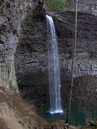
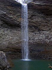
, a 110 feet (33.5 m) plunge waterfall, and its immediate gorge along Fall Creek.
The area is managed by the Tennessee Department of Environment and Conservation
Tennessee Department of Environment and Conservation
The Tennessee Department of Environment and Conservation is a Cabinet-level agency within the government of the U.S. state of Tennessee, headed by the Tennessee Commissioner of Environment and Conservation....
and maintained by Cumberland Mountain State Park
Cumberland Mountain State Park
Cumberland Mountain State Park is a state park in Cumberland County, Tennessee, in the southeastern United States. The park consists of situated around Byrd Lake, a man-made lake created by the impoundment of Byrd Creek in the 1930s...
.
Geographical setting
Ozone Falls
Ozone Falls is the name of two waterfalls in the United States:*Ozone Falls in Tennessee*One of 24 named waterfalls in Ricketts Glen State Park in Pennsylvania...
is situated along Fall Creek, which drains a short section of the Cumberland Plateau
Cumberland Plateau
The Cumberland Plateau is the southern part of the Appalachian Plateau. It includes much of eastern Kentucky and western West Virginia, part of Tennessee, and a small portion of northern Alabama and northwest Georgia . The terms "Allegheny Plateau" and the "Cumberland Plateau" both refer to the...
between the Crab Orchard Mountains
Crab Orchard Mountains
The Crab Orchard Mountains are a rugged, detached range of the southern Cumberland Mountains. They are situated in East Tennessee atop the Cumberland Plateau just west of the plateau's eastern escarpment, and comprise parts of Morgan, Anderson, and Cumberland counties. The Crab Orchard Mountains...
to the west and Walden Ridge
Walden Ridge
Walden Ridge is a mountain ridge and escarpment located in Tennessee, in the United States. It marks the eastern edge of the Cumberland Plateau and is generally considered part of it. Walden Ridge is about long, running generally north-south...
to the east. The creek flows down from its source high in the Crab Orchard Mountains for a mile or so before steadying briefly as it enters the community of Ozone
Ozone, Tennessee
Ozone is an unincorporated community in Cumberland County, Tennessee, in the Southeastern United States. Ozone is the location of Ozone Falls State Natural Area, which was established in 1973 to protect Ozone Falls, a 110-foot plunge waterfall, and its surrounding gorge.-Geography:Ozone is located...
. Fall Creek enters the state natural area just after it passes under U.S. Route 70
U.S. Route 70
U.S. Route 70 is an east–west United States highway that runs for 2,385 miles from eastern North Carolina to east-central Arizona. As can be derived from its number, it is a major east–west highway of the Southern and Southwestern United States...
, which runs perpendicular to it. The creek spills over Ozone Falls a few hundred meters south of US-70.
Beyond Ozone Falls, Fall Creek slices through a small gorge and proceeds southward for several more miles before emptying into Piney Creek. The confluence of Piney and Fall Creek occurs at a point where Roane County, Cumberland County, and Rhea County
Rhea County, Tennessee
Rhea County is a county located in the U.S. state of Tennessee. As of 2000, the population was 28,400. Its county seat is Dayton.-Geography:According to the U.S...
all meet. Fall Creek is part of the Tennessee River
Tennessee River
The Tennessee River is the largest tributary of the Ohio River. It is approximately 652 miles long and is located in the southeastern United States in the Tennessee Valley. The river was once popularly known as the Cherokee River, among other names...
watershed.
The Fall Creek that spills over Ozone Falls is not the same stream as the Fall Creek that spills over Fall Creek Falls
Fall Creek Falls
Fall Creek Falls is the highest free-fall waterfall east of the Mississippi River. The falls are located near Spencer, Tennessee in Fall Creek Falls State Park. A short trail leads from the parking lot atop the plateau down to the base of the gorge, giving access to the waterfall's plungepool. ...
in Van Buren County. The latter stream is part of the Cumberland River
Cumberland River
The Cumberland River is a waterway in the Southern United States. It is long. It starts in Harlan County in far southeastern Kentucky between Pine and Cumberland mountains, flows through southern Kentucky, crosses into northern Tennessee, and then curves back up into western Kentucky before...
watershed.
Features
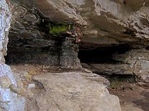
The Ozone Falls State Natural Area consists of Ozone Falls and the gorge immediately downstream. The gorge area around the waterfall's plungepool slopes inward from the top edge, creating a half-dome shape along the gorge's walls. Short hiking trails allow access to the waterfall's overhang and plungepool, as well as the cliffs above the gorge. The trailhead is located along US-70.History
Cumberland Plateau
The Cumberland Plateau is the southern part of the Appalachian Plateau. It includes much of eastern Kentucky and western West Virginia, part of Tennessee, and a small portion of northern Alabama and northwest Georgia . The terms "Allegheny Plateau" and the "Cumberland Plateau" both refer to the...
en route to the Nashville
Nashville, Tennessee
Nashville is the capital of the U.S. state of Tennessee and the county seat of Davidson County. It is located on the Cumberland River in Davidson County, in the north-central part of the state. The city is a center for the health care, publishing, banking and transportation industries, and is home...
area in the early 19th century wrote of Ozone Falls
Ozone Falls
Ozone Falls is the name of two waterfalls in the United States:*Ozone Falls in Tennessee*One of 24 named waterfalls in Ricketts Glen State Park in Pennsylvania...
in journals and letters sent to relatives back home. The waterfall was located adjacent to the Walton Road, which was part of the stage
Stagecoach
A stagecoach is a type of covered wagon for passengers and goods, strongly sprung and drawn by four horses, usually four-in-hand. Widely used before the introduction of railway transport, it made regular trips between stages or stations, which were places of rest provided for stagecoach travelers...
route connecting East and Middle Tennessee (the road closely paralleled what is now US-70). One traveler along this road, Elijah Haley, died while passing through the area in 1806. His widow established a tavern at what is now the community of Ozone shortly thereafter, and later helped operate the Crab Orchard Inn at Crab Orchard
Crab Orchard, Tennessee
Crab Orchard is a city in Cumberland County, Tennessee, United States. The population was 838 at the 2000 census.-Geography:Crab Orchard is located at . The town is situated atop the Cumberland Plateau in a gap amidst the Crab Orchard Mountains, a sub-range of the Cumberland Mountains...
, a few miles to the west.
The waterfall was known as McNair Falls throughout the 19th century, named after a local miller who operated a grist mill
Gristmill
The terms gristmill or grist mill can refer either to a building in which grain is ground into flour, or to the grinding mechanism itself.- Early history :...
at the waterfall in the 1860s. In 1896, the community of Mammy, which had grown up around the Haley tavern, changed its name to "Ozone", and the name was subsequently applied to the waterfall. The name reflected the high quality of air in the community, which may have been enhanced by the waterfall's mists.
The Ozone Falls State Natural Area was established in 1973, and originally consisted of 14 acres (56,656 m²). In 1996, it was expanded to 43 acres (174,015 m²).
External links
- Ozone Falls State Natural Area — official site