

Torridonian
Encyclopedia

Geology
Geology is the science comprising the study of solid Earth, the rocks of which it is composed, and the processes by which it evolves. Geology gives insight into the history of the Earth, as it provides the primary evidence for plate tectonics, the evolutionary history of life, and past climates...
, Torridonian describes a series of Neoproterozoic
Neoproterozoic
The Neoproterozoic Era is the unit of geologic time from 1,000 to 542.0 ± 1.0 million years ago. The terminal Era of the formal Proterozoic Eon , it is further subdivided into the Tonian, Cryogenian, and Ediacaran Periods...
arenaceous sedimentary rock
Sedimentary rock
Sedimentary rock are types of rock that are formed by the deposition of material at the Earth's surface and within bodies of water. Sedimentation is the collective name for processes that cause mineral and/or organic particles to settle and accumulate or minerals to precipitate from a solution....
s, extensively developed in the Northwest Highlands
Northwest Highlands
The Northwest Highlands are the northern third of Scotland that is separated from the Grampian Mountains by the Great Glen . The region comprises , Assynt, Caithness and Sutherland. The Caledonian Canal, which extends from Loch Linnhe in the west, via Loch Ness to the Moray Firth in the north...
of Scotland
Scotland
Scotland is a country that is part of the United Kingdom. Occupying the northern third of the island of Great Britain, it shares a border with England to the south and is bounded by the North Sea to the east, the Atlantic Ocean to the north and west, and the North Channel and Irish Sea to the...
, and particularly in the district of upper Loch Torridon
Loch Torridon
Loch Torridon is a sea loch on the west coast of Scotland in the Northwest Highlands. The loch was created by glacial processes and is in total around 15 miles long. It has two sections: Upper Loch Torridon to landward, east of Rubha na h-Airde Ghlaise, at which point it joins Loch Sheildaig;...
, a circumstance which suggested the name Torridon Sandstone, first applied to these rocks by James Nicol
James Nicol
James Nicol , Scottish geologist, was born at Traquair, near Innerleithen, in Peeblesshire.His father, the Rev. James Nicol , was minister of Traquair, and acquired some celebrity as a poet. Educated at Edinburgh University , James Nicol attended the lectures of Robert Jameson, gaining a keen...
. They lie unconformably on gneiss
Gneiss
Gneiss is a common and widely distributed type of rock formed by high-grade regional metamorphic processes from pre-existing formations that were originally either igneous or sedimentary rocks.-Etymology:...
es of the Lewisian complex
Lewisian complex
The Lewisian complex or Lewisian Gneiss is a suite of Precambrian metamorphic rocks that outcrop in the northwestern part of Scotland, forming part of the Hebridean Terrane. These rocks are of Archaean and Paleoproterozoic age, ranging from 3.0–1.7 Ga. They form the basement on which the...
and their outcrop is restricted to the Hebridean Terrane
Hebridean Terrane
The Hebridean Terrane is one of the terranes that form part of the Caledonian orogenic belt in northwest Scotland. Its boundary with the neighbouring Northern Highland Terrane is formed by the Moine Thrust Belt...
.
Rock type
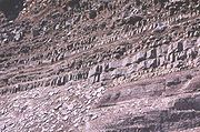
The rocks are mainly red and chocolate sandstoneSandstone
Sandstone is a sedimentary rock composed mainly of sand-sized minerals or rock grains.Most sandstone is composed of quartz and/or feldspar because these are the most common minerals in the Earth's crust. Like sand, sandstone may be any colour, but the most common colours are tan, brown, yellow,...
s, arkose
Arkose
Arkose is a detrital sedimentary rock, specifically a type of sandstone containing at least 25% feldspar. Arkosic sand is sand that is similarly rich in feldspar, and thus the potential precursor of arkose....
s and shale
Shale
Shale is a fine-grained, clastic sedimentary rock composed of mud that is a mix of flakes of clay minerals and tiny fragments of other minerals, especially quartz and calcite. The ratio of clay to other minerals is variable. Shale is characterized by breaks along thin laminae or parallel layering...
s with coarse conglomerate
Conglomerate (geology)
A conglomerate is a rock consisting of individual clasts within a finer-grained matrix that have become cemented together. Conglomerates are sedimentary rocks consisting of rounded fragments and are thus differentiated from breccias, which consist of angular clasts...
s locally at the base. Some of the materials of these rocks were derived from the underlying Lewisian gneiss
Lewisian complex
The Lewisian complex or Lewisian Gneiss is a suite of Precambrian metamorphic rocks that outcrop in the northwestern part of Scotland, forming part of the Hebridean Terrane. These rocks are of Archaean and Paleoproterozoic age, ranging from 3.0–1.7 Ga. They form the basement on which the...
, upon the uneven surface of which they rest, but the bulk of the material was obtained from rocks that are nowhere now exposed. Upon this ancient denuded land surface the Torridonian strata rest horizontally or with gentle inclination
Inclination
Inclination in general is the angle between a reference plane and another plane or axis of direction.-Orbits:The inclination is one of the six orbital parameters describing the shape and orientation of a celestial orbit...
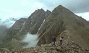
. Some of the peaks, such as Beinn Eighe
Beinn Eighe
Beinn Eighe is a complex mountain massif in the Torridon area of the Highlands of Scotland. It forms a long ridge with many spurs and summits, two of which are classified as Munros. The name Beinn Eighe comes from the Scottish Gaelic meaning File Mountain...
, are capped with white Cambrian
Cambrian
The Cambrian is the first geological period of the Paleozoic Era, lasting from Mya ; it is succeeded by the Ordovician. Its subdivisions, and indeed its base, are somewhat in flux. The period was established by Adam Sedgwick, who named it after Cambria, the Latin name for Wales, where Britain's...
quartzite
Quartzite
Quartzite is a hard metamorphic rock which was originally sandstone. Sandstone is converted into quartzite through heating and pressure usually related to tectonic compression within orogenic belts. Pure quartzite is usually white to gray, though quartzites often occur in various shades of pink...
, giving them a distinctive appearance when seen from afar. Some of the quartzite contains fossilized worm burrows and is known as pipe rock. It is circa 500 million years old. The Torridon landscape
Landscape
Landscape comprises the visible features of an area of land, including the physical elements of landforms such as mountains, hills, water bodies such as rivers, lakes, ponds and the sea, living elements of land cover including indigenous vegetation, human elements including different forms of...
is itself highly denuded by glacial and alluvial action, and represents the remnants of an ancient peneplain
Peneplain
A peneplain is a low-relief plain representing the final stage of fluvial erosion during times of extended tectonic stability. The existence of peneplains, and peneplanation as a geomorphological process, is not without controversy, due to a lack of contemporary examples and uncertainty in...
.
Occurrence
Their outcrop extends in a belt of variable breadth from Cape WrathCape Wrath
Cape Wrath is a cape in Sutherland, Highland, in northern Scotland. It is the most northwesterly point on the island of Great Britain. The land between the Kyle of Durness and the lighthouse that is situated right at the tip, is known as the Parph, two hundred and seven square kilometers of...
to the Point of the peninsula of Sleat
Sleat
Sleat is a peninsula on the island of Skye in the Highland council area of Scotland, known as "the garden of Skye". It is the home of the clan MacDonald of Sleat...
in Skye, running in a N.N.E.-S.S.W. direction through Caithness
Caithness
Caithness is a registration county, lieutenancy area and historic local government area of Scotland. The name was used also for the earldom of Caithness and the Caithness constituency of the Parliament of the United Kingdom . Boundaries are not identical in all contexts, but the Caithness area is...
, Sutherland
Sutherland
Sutherland is a registration county, lieutenancy area and historic administrative county of Scotland. It is now within the Highland local government area. In Gaelic the area is referred to according to its traditional areas: Dùthaich 'IcAoidh , Asainte , and Cataibh...
, Ross and Cromarty
Ross and Cromarty
Ross and Cromarty is a variously defined area in the Highlands and Islands of Scotland. There is a registration county and a lieutenancy area in current use...
, and Skye and Lochalsh
Skye and Lochalsh
Skye and Lochalsh is one of eight former local government districts of the two-tier Highland region of Scotland. The main offices of the Skye and Lochalsh district council were in Portree, on the Isle of Skye.-History:...
. They form the isolated mountain peaks of Canisp
Canisp
Canisp is a mountain in the far north west of Scotland. It is situated in the parish of Assynt, in the county of Sutherland, 25 kilometres north of the town of Ullapool. Canisp reaches a height of 847 metres and qualifies as a Corbett and Marilyn hill...
, Quinag
Quinag
The mountain Quinag in Sutherland, in the Scottish Highlands, is in fact a mountain range with an undulating series of peaks along its Y-shaped crest...
and Suilven
Suilven
Suilven is one of the most distinctive mountains in Scotland. Lying in a remote area in the west of Sutherland, it rises almost vertically from a wilderness landscape of moorland, bogs and lochans known as Inverpolly National Nature Reserve....
in the area of Loch Assynt
Loch Assynt
Loch Assynt is a freshwater loch in Sutherland, Scotland, 8 km ENE of Lochinver.Situated in a spectacular setting between the heights of Canisp, Quinag and Beinn Uidhe, it receives the outflow from Lochs Awe, Maol a' Choire, and Leitir Easaich. It discharges into the sea at Loch Inver, via the...
, of Slioch
Slioch
Slioch is a mountain in the Scottish Highlands situated in Wester Ross, eight kilometres north of the village of Kinlochewe. Slioch reaches a height of 981 metres and towers above the south east end of Loch Maree to give one of the best known and most photographed sights in the Highlands...
near Loch Maree
Loch Maree
Loch Maree is a loch in Wester Ross in the Northwest Highlands of Scotland. At long and with a maximum width of , it is the fourth largest freshwater loch in Scotland; it is the largest north of Loch Ness. Its surface area is ....
, and other hills. They attain their maximum development in the Applecross
Applecross
The Applecross peninsula is a peninsula in Wester Ross, Highland, on the west coast of Scotland. The name Applecross is at least 1300 years old and is not used locally to refer to the 19th century village with the pub and post office, lying on the small Applecross Bay, facing the Inner Sound, on...
, Gairloch
Gairloch
Gairloch is a village, civil parish and community on the shores of Loch Gairloch on the northwest coast of Scotland. A popular tourist destination in the summer months, Gairloch has a golf course, a small museum, several hotels, a community centre, a leisure centre with sports facilities, a local...
and Torridon
Torridon
Torridon is a small village in the Northwest Highlands of Scotland. However the name is also applied to the area surrounding the village, particularly the Torridon Hills, mountains to the north of Glen Torridon. It lies on the shore of Loch Torridon.Torridon is on the west coast of Scotland, ...
districts, form the greater part of Scalpay
Scalpay, Inner Hebrides
Scalpay is an island in the Inner Hebrides of Scotland.Separated from the east coast of Skye by Loch na Cairidh, Scalpay rises to at Mullach na Càrn. It has an area of almost ten sq. miles....
, and occur also in Rùm
Rùm
Rùm , a Scottish Gaelic name often anglicised to Rum) is one of the Small Isles of the Inner Hebrides, in the district of Lochaber, Scotland...
, Raasay
Raasay
Raasay is an island between the Isle of Skye and the mainland of Scotland. It is separated from Skye by the Sound of Raasay and from Applecross by the Inner Sound. It is most famous for being the birthplace of the poet Sorley MacLean, an important figure in the Scottish literary renaissance...
, Soay and the Crowlin Islands
Crowlin Islands
The Crowlin Islands are a group of uninhabited islands in the Inner Hebrides of Scotland. They lie between Skye and the Applecross peninsula on the mainland.The individual islands are:*Eilean Mòr *Eilean Meadhonach...
. They are also found beneath much of the Sea of the Hebrides
Sea of the Hebrides
The Sea of the Hebrides is a portion of the North Atlantic Ocean, located off the coast of western Scotland, separating the mainland and the northern Inner Hebrides islands from the southern Outer Hebrides islands...
overlying the Lewisian gneiss.
Sub-divisions
The Torridonian is divided into the older Stoer Group and the younger Sleat and Torridon Groups separated by an angular unconformity. Paleomagnetic dataPaleomagnetism
Paleomagnetism is the study of the record of the Earth's magnetic field in rocks. Certain minerals in rocks lock-in a record of the direction and intensity of the magnetic field when they form. This record provides information on the past behavior of Earth's magnetic field and the past location of...
suggest that this unconformity represents a major time break. These sediments are interpreted to have been deposited during a period of rift
Rift
In geology, a rift or chasm is a place where the Earth's crust and lithosphere are being pulled apart and is an example of extensional tectonics....
ing.
Stoer Group
The Stoer Group outcrops on the peninsula of StoerStoer
Stoer is a crofting township in the parish of Assynt, Sutherland, in the Highlands of Scotland and in the council area of Highland. It is located about five miles north of the village of Lochinver....
, near Assynt
Assynt
Assynt is a civil parish in west Sutherland, Highland, Scotland – north of Ullapool.It is famous for its landscape and its remarkable mountains...
, Sutherland
Sutherland
Sutherland is a registration county, lieutenancy area and historic administrative county of Scotland. It is now within the Highland local government area. In Gaelic the area is referred to according to its traditional areas: Dùthaich 'IcAoidh , Asainte , and Cataibh...
. It is subdivided into three formations.
Clachtoll Formation
A basal brecciaBreccia
Breccia is a rock composed of broken fragments of minerals or rock cemented together by a fine-grained matrix, that can be either similar to or different from the composition of the fragments....
is present in many areas with large clasts derived form the underlying Lewisian. There is local evidence of weathering of the gneiss beneath the unconformity. Away from the unconformity the breccia becomes crudely stratified within an overall fining upwards sequence passing up into pebbly sandstones, the deposits of small alluvial fans. This breccia facies passes vertically and laterally in most places into muddy massive sandstones, true greywacke
Greywacke
Greywacke or Graywacke is a variety of sandstone generally characterized by its hardness, dark color, and poorly sorted angular grains of quartz, feldspar, and small rock fragments or lithic fragments set in a compact, clay-fine matrix. It is a texturally immature sedimentary rock generally found...
s. The lower part of these sandstones are almost unbedded being replaced upwards by half metre thick beds capped by siltstones often with well-preserved desiccation structures. In parts of the outcrop, the muddy sandstones are succeeded by the deposits of a braided river
Braided river
A braided river is one of a number of channel types and has a channel that consists of a network of small channels separated by small and often temporary islands called braid bars or, in British usage, aits or eyots. Braided streams occur in rivers with high slope and/or large sediment load...
system, trough cross-bedded sandstones and conglomerates
Conglomerate (geology)
A conglomerate is a rock consisting of individual clasts within a finer-grained matrix that have become cemented together. Conglomerates are sedimentary rocks consisting of rounded fragments and are thus differentiated from breccias, which consist of angular clasts...
.
Bay of Stoer Formation
The Bay of Stoer Formation consists of a lower section formed of red trough cross-bedded sandstones with some pebbles, interpreted to be the deposits of a braided river system. The uppermost 100 m of the formation, the Stac Fada and Poll a' Mhuilt members, form a distinctive marker layer within the Stoer Group succession with a strikeStrike and dip
Strike and dip refer to the orientation or attitude of a geologic feature. The strike line of a bed, fault, or other planar feature is a line representing the intersection of that feature with a horizontal plane. On a geologic map, this is represented with a short straight line segment oriented...
extent of 50 km. The Stac Fada member is generally about 10 m thick and consists of muddy sandstone facies with abundant clasts of vesicular
Vesicular texture
Vesicular texture is a volcanic rock texture characterised by a rock being pitted with many cavities at its surface and inside. The texture is often found in extrusive aphanitic, or glassy, igneous rock...
volcanic glass
Volcanic glass
Volcanic glass is the amorphous product of rapidly cooling magma. Like all types of glass, it is a state of matter intermediate between the close-packed, highly ordered array of a crystal and the highly disordered array of gas...
, locally with accretionary lapilli
Lapilli
Lapilli is a size classification term for tephra, which is material that falls out of the air during a volcanic eruption or during some meteorite impacts. Lapilli means "little stones" in Latin. They are in some senses similar to ooids or pisoids in calcareous sediments.By definition lapilli range...
. The matrix for these volcanic clasts is always non-volcanic suggesting transport from the area where they were erupted. The member also includes large rafts of gneiss and sandstone, up to 15 m in length. The Stac Fada member has been traditionally interpreted to be a mudflow. An alternative suggestion has been that the member represents part of the proximal ejecta blanket from an impact crater
Impact crater
In the broadest sense, the term impact crater can be applied to any depression, natural or manmade, resulting from the high velocity impact of a projectile with a larger body...
. This interpretation is supported by the presence of shocked quartz
Shocked quartz
Shocked quartz is a form of quartz that has a microscopic structure that is different from normal quartz. Under intense pressure , the crystalline structure of quartz will be deformed along planes inside the crystal...
and biotite
Biotite
Biotite is a common phyllosilicate mineral within the mica group, with the approximate chemical formula . More generally, it refers to the dark mica series, primarily a solid-solution series between the iron-endmember annite, and the magnesium-endmember phlogopite; more aluminous endmembers...
. The overlying Poll a' Mhuilt member consists of a thin sequence of siltstones and fine sandstones alternating with muddy sandstones, suggesting deposition in a lacustrine
Lacustrine
Lacustrine means "of a lake" or "relating to a lake".Specifically, it may refer to:*Lacustrine plain*Lacustrine delta-Fish:*Lacustrine goby , a type of small fish found in Philippine waters belonging to the Gobiidae family, known in Tagalog as dulong-See also:*Fluvial - of or relating a...
environment.
Meall Deag Formation
The uppermost part of the sequence consists of trough cross-bedded sandstones thought to have been deposited by braided rivers, similar to the lower part of the Bay of Stoer Formation, possibly with wider channels and a lower paleoslope.Sleat Group
The Sleat Group, which outcrops on the SleatSleat
Sleat is a peninsula on the island of Skye in the Highland council area of Scotland, known as "the garden of Skye". It is the home of the clan MacDonald of Sleat...
peninsula on Skye
Skye
Skye or the Isle of Skye is the largest and most northerly island in the Inner Hebrides of Scotland. The island's peninsulas radiate out from a mountainous centre dominated by the Cuillin hills...
, underlies the Torridon Group conformably, but the relationship with the Stoer Group is nowhere exposed. It is presumed to have been in deposited later that the Stoer Group, but possibly in a separate sub-basin. It is metamorphosed to greenschist facies and sits within the Kishorn Nappe, part of the Caledonian
Caledonian orogeny
The Caledonian orogeny is a mountain building era recorded in the northern parts of the British Isles, the Scandinavian Mountains, Svalbard, eastern Greenland and parts of north-central Europe. The Caledonian orogeny encompasses events that occurred from the Ordovician to Early Devonian, roughly...
thrust belt
Thrust fault
A thrust fault is a type of fault, or break in the Earth's crust across which there has been relative movement, in which rocks of lower stratigraphic position are pushed up and over higher strata. They are often recognized because they place older rocks above younger...
, making its exact relationship to the other outcrops difficult to assess. The sequence consists of mainly coarse feldspathic
Feldspar
Feldspars are a group of rock-forming tectosilicate minerals which make up as much as 60% of the Earth's crust....
sandstones deposited in a fluvial environment with some less common grey shale
Shale
Shale is a fine-grained, clastic sedimentary rock composed of mud that is a mix of flakes of clay minerals and tiny fragments of other minerals, especially quartz and calcite. The ratio of clay to other minerals is variable. Shale is characterized by breaks along thin laminae or parallel layering...
s, probably deposited in a lacustrine environment.
Rubha Guail Formation
The unconformityUnconformity
An unconformity is a buried erosion surface separating two rock masses or strata of different ages, indicating that sediment deposition was not continuous. In general, the older layer was exposed to erosion for an interval of time before deposition of the younger, but the term is used to describe...
at the base of the Sleat Group is not exposed on Skye, but at Kyle of Lochalsh
Kyle of Lochalsh
Kyle of Lochalsh is a village on the northwest coast of Scotland, 63 miles west of Inverness. It is located at the entrance to Loch Alsh, opposite the village of Kyleakin on the Isle of Skye...
, the basal part of the sequence is seen to consist of breccias, with clasts derived from the underlying gneiss. Topographic relief
Topography
Topography is the study of Earth's surface shape and features or those ofplanets, moons, and asteroids...
on the unconformity reaches several hundred metres.
Most of the remaining part of the formation consists of coarse green trough cross-bedded sandstones, the colour coming from its content of epidote
Epidote
Epidote is a calcium aluminium iron sorosilicate mineral, Ca2Al2O, crystallizing in the monoclinic system. Well-developed crystals are of frequent occurrence: they are commonly prismatic in habit, the direction of elongation being perpendicular to the single plane of symmetry. The faces are often...
and chlorite
Chlorite group
The chlorites are a group of phyllosilicate minerals. Chlorites can be described by the following four endmembers based on their chemistry via substitution of the following four elements in the silicate lattice; Mg, Fe, Ni, and Mn....
. The coarse sandstone beds are interbedded with fine-grained sandstones and siltstones, which become more common towards the top of the formation. The siltstones show desiccation features. The formation shows an overall upward-fining trend, which continued with the overlying Loch na Dal Formation siltstones.
Loch na Dal Formation
The basal part of this formation is formed of laminated dark-grey siltstones. This 200 m thick unit is often phosphaticPhosphorite
Phosphorite, phosphate rock or rock phosphate is a non-detrital sedimentary rock which contains high amounts of phosphate bearing minerals. The phosphate content of phosphorite is at least 15 to 20% which is a large enrichment over the typical sedimentary rock content of less than 0.2%...
and contains occasional coarse to very coarse sandstone laminae. It is interpreted to represent the maximum expansion of a lake. The upper part of the formation is composed mainly of coarse, occasionally pebbly, trough cross-bedded sandstones, interpreted to record the building out of a series of delta
River delta
A delta is a landform that is formed at the mouth of a river where that river flows into an ocean, sea, estuary, lake, reservoir, flat arid area, or another river. Deltas are formed from the deposition of the sediment carried by the river as the flow leaves the mouth of the river...
s into the earlier lake.
Beinn na Seamraig Formation
This formation consist of coarse-grained cross-bedded sandstones, typically showing contorted bedding.Kinloch Formation
This formation is similar to the underlying Beinn na Seamraig Formation. The main difference is that the sandstones are generally finer-grained than those below and have better developed ripple-drift lamination. The sediments show marked cyclicity, with fining upward cycles, 25–35 m thick, with shales developed at the top. The uppermost boundary of this group with the overlying Torridon Group has been interpreted to be conformable, with evidence of interfingering between the Kinloch Formation shales and Applecross Formation sandstones. In support of this observation, there are no sandstone clasts above the boundary and no change in magnetisationPaleomagnetism
Paleomagnetism is the study of the record of the Earth's magnetic field in rocks. Certain minerals in rocks lock-in a record of the direction and intensity of the magnetic field when they form. This record provides information on the past behavior of Earth's magnetic field and the past location of...
between the formations. The main difference is in the degree of albitisation
Albite
Albite is a plagioclase feldspar mineral. It is the sodium endmember of the plagioclase solid solution series. As such it represents a plagioclase with less than 10% anorthite content. The pure albite endmember has the formula NaAlSi3O8. It is a tectosilicate. Its color is usually pure white, hence...
of the feldspars; those in the Sleat Group are only partially affect while those in the Applecross Formation are completely albitised. There is also some evidence for a change in bedding orientation across the boundary, which is nowhere well-exposed, suggesting that it may represent some sort of disconformity.
Torridon Group
The Torridon Group infills an irregular land surface with up to 600 m of topography locally, cutting down through the previously deposited Stoer group sediments, resting in many areas directly on the Lewisian. It has been suggested that there is significant unconformity within this group, between the Diabaig and Applecross Formations.Diabaig Formation
The lowest part of this formation consists of a basal breccia containing clasts derived from the underlying Lewisian complex with the thickest developments in the paleovalleys. The breccias passing vertically and laterally into tabular sandstones. Theses are locally channelised and interfinger with grey shales containing thin beds of fine-grained sandstone with wave rippled surfaces. The shales show the effects of desiccation with mudcracks preserved by being filled by overlying sandstone layers. In the upper part of the formation, beds of massive sandstone with sharp bases appear, becoming more common and thicker bedded towards the top. Ripple-drift lamination at the top of the sandstone layers indicates deposition from easterly-flowing currents. This sequence is interpreted to be to represent the progressive infill of the topography by alluvial fanAlluvial fan
An alluvial fan is a fan-shaped deposit formed where a fast flowing stream flattens, slows, and spreads typically at the exit of a canyon onto a flatter plain. A convergence of neighboring alluvial fans into a single apron of deposits against a slope is called a bajada, or compound alluvial...
s building out into ephemeral lakes. The more massive beds are interpreted to be lake turbidite
Turbidite
Turbidite geological formations have their origins in turbidity current deposits, which are deposits from a form of underwater avalanche that are responsible for distributing vast amounts of clastic sediment into the deep ocean.-The ideal turbidite sequence:...
s.
Applecross Formation
This formation consists of coarse sandstones, both trough and planar cross-bedded. The orientation of the troughs suggest a paleocurrent flowing from the Northwest. The sandstones carry a distinctive set of pebbles, including jasperJasper
Jasper, a form of chalcedony, is an opaque, impure variety of silica, usually red, yellow, brown or green in color; and rarely blue. This mineral breaks with a smooth surface, and is used for ornamentation or as a gemstone. It can be highly polished and is used for vases, seals, and at one time for...
and porphyry
Porphyry (geology)
Porphyry is a variety of igneous rock consisting of large-grained crystals, such as feldspar or quartz, dispersed in a fine-grained feldspathic matrix or groundmass. The larger crystals are called phenocrysts...
. Most of the sandstone beds are affected by soft-sediment deformation structures suggesting liquefaction
Soil liquefaction
Soil liquefaction describes a phenomenon whereby a saturated soil substantially loses strength and stiffness in response to an applied stress, usually earthquake shaking or other sudden change in stress condition, causing it to behave like a liquid....
, possibly as a result of seismic activity
Earthquake
An earthquake is the result of a sudden release of energy in the Earth's crust that creates seismic waves. The seismicity, seismism or seismic activity of an area refers to the frequency, type and size of earthquakes experienced over a period of time...
. The uppermost part of the formation consists of finer-grained sandstones, transitional to those of the overlying Aultbea Formation. At Cape Wrath
Cape Wrath
Cape Wrath is a cape in Sutherland, Highland, in northern Scotland. It is the most northwesterly point on the island of Great Britain. The land between the Kyle of Durness and the lighthouse that is situated right at the tip, is known as the Parph, two hundred and seven square kilometers of...
the basal part of the formation shows a fanning of paleocurrent directions consistent with deposition from a large alluvial fan (~40 km radius) with its apex near the Minch Fault. The source area for this fan has been calculated as about 10,000 km2.
Aultbea Formation
The Applecross and Aultbea Formations together consist of an overall fining-upward sequence of sandstones. Only the outcrops at Cape Wrath
Cape Wrath
Cape Wrath is a cape in Sutherland, Highland, in northern Scotland. It is the most northwesterly point on the island of Great Britain. The land between the Kyle of Durness and the lighthouse that is situated right at the tip, is known as the Parph, two hundred and seven square kilometers of...
described above have a consistent radial pattern suggesting that the sequence was deposited in a bajada
Bajada
Bajada may refer to:*Bajada a festival common to the Canary islands* Bajada, a compound Alluvial fan* La Bajada, an escarpment of the Caja del Rio, New Mexico, USA* Clint Bajada , Maltese TV and radio personality...
environment, by a series of smaller fans merging together to form a braided river system.
Cailleach Head Formation
This formation is similar to the underlying Aultbea Formation, the main difference being in grain size, with this formation being noticeably finer-grained. The sequence is made up of 22 m thick cycles, each with a basal erosion surface followed by dark grey shales with desiccation cracks, planar cross-bedded sandstones with wave rippled tops, overlain by trough cross-bedded micaMica
The mica group of sheet silicate minerals includes several closely related materials having highly perfect basal cleavage. All are monoclinic, with a tendency towards pseudohexagonal crystals, and are similar in chemical composition...
ceous sandstones. These cycles are thought to represent repeated progradation of deltas into a lake. A lack of evaporite
Evaporite
Evaporite is a name for a water-soluble mineral sediment that result from concentration and crystallization by evaporation from an aqueous solution. There are two types of evaporate deposits, marine which can also be described as ocean deposits, and non-marine which are found in standing bodies of...
minerals suggest that the lakes had through drainage. Acritarch
Acritarch
Acritarchs are small organic fossils, present from approximately to the present. Their diversity reflects major ecological events such as the appearance of predation and the Cambrian explosion.-Definition:In general, any small, non-acid soluble Acritarchs are small organic fossils, present from...
microfossils
Micropaleontology
Micropaleontology is the branch of paleontology that studies microfossils.-Microfossils:...
were described from here by Teall in 1907, the first Precambrian
Precambrian
The Precambrian is the name which describes the large span of time in Earth's history before the current Phanerozoic Eon, and is a Supereon divided into several eons of the geologic time scale...
fossils described in Britain.
Age
The upper age limit for the deposition of this sequence is constrained by the age of the last tectonic and metamorphic event to affect the Lewisian complex on which it was deposited, for which ages cluster between about 1200–1100 Ma. The lower limit is provided by the age of the lower Cambrian quartzite that lies above it, about 544 Ma. Radiometric agesRadiometric dating
Radiometric dating is a technique used to date materials such as rocks, usually based on a comparison between the observed abundance of a naturally occurring radioactive isotope and its decay products, using known decay rates...
from the Torridonian sequence itself give ages of about 1200 Ma for the Stoer Group and 1000–950 for the basal part of the Torridon Group. This implies an age gap of at least 200 Ma between the deposition of these two groups, consistent with the paleomagnetic evidence. Ages of detrital zircon
Zircon
Zircon is a mineral belonging to the group of nesosilicates. Its chemical name is zirconium silicate and its corresponding chemical formula is ZrSiO4. A common empirical formula showing some of the range of substitution in zircon is 1–x4x–y...
s also provide some constraints on the sequence age. The Stoer group and the lower part of the Sleat Group show ages conistent with derivation from Scourian and to a lesser extent Laxfordian rocks, with no dates after 1700 Ma. The upper part of the Sleat Group includes a large component of broadly Laxfordian age with almost no Archaean ages, with a lower limit of about 1200 Ma. In contrast the Diabaig Formation shows a small group clustered around 1100 Ma, the age of the Grenville Orogeny
Grenville orogeny
The Grenville Orogeny was a long-lived Mesoproterozoic mountain-building event associated with the assembly of the supercontinent Rodinia. Its record is a prominent orogenic belt which spans a significant portion of the North American continent, from Labrador to Mexico, as well as to Scotland...
. In the Applecross and Aultbea Formations there are many more zircons giving ages around 1100 Ma and even below 1000 Ma. This evidence suggest that the Stour and Sleat Groups were deposited before the Grenvillian event, pre-1200 Ma, while the Diabaig Formation was deposited after the orogeny, after about 1090 Ma, and the remaining parts of the Torridon Group after about 1060 Ma. A more precise age has been obtained for authigenic
Authigenic
An authigenic mineral or sedimentary rock deposit is one that was generated where it is found or observed. Authigenic sedimentary minerals form during sedimentation by precipitation or recrystallization instead of being transported from elsewhere by water or wind. Authigenic sediments are the main...
feldspars in the Stac Fada Member of the Stoer Group at 1177±5 Ma interpreted to have formed immediately after emplacement of the ejecta blanket.
Tectonic setting
Variations in thickness and lithologyLithology
The lithology of a rock unit is a description of its physical characteristics visible at outcrop, in hand or core samples or with low magnification microscopy, such as colour, texture, grain size, or composition. It may be either a detailed description of these characteristics or be a summary of...
are consistent with both the Stoer and Sleat/Torridon Groups being deposited in a rift setting. Evidence from seismic reflection
Reflection seismology
Reflection seismology is a method of exploration geophysics that uses the principles of seismology to estimate the properties of the Earth's subsurface from reflected seismic waves. The method requires a controlled seismic source of energy, such as dynamite/Tovex, a specialized air gun or a...
data in the Minch suggests that the Minch Fault was active throughout the deposition of the Torridon Group. This is consistent with the generally westerly derived pebbly material throughout the thickness of the Applecross Formation, suggesting a constantly rejuvenated sediment source in that direction. More recent work has suggested that although the Stoer and Sleat Groups were probably deposited in a rift setting, the scale and continuity of the Torridon Group, particularly the Applecross and Aultbea Formations, is more consistent with a molasse
Molasse
The term "molasse" refers to the sandstones, shales and conglomerates formed as terrestrial or shallow marine deposits in front of rising mountain chains. The molasse is deposited in a foreland basin, especially on top of flysch, for example that left from the rising Alps, or erosion in the Himalaya...
type setting possibly related to the Grenvillian Orogeny.