
Suilven
Encyclopedia
Suilven is one of the most distinctive mountain
s in Scotland
. Lying in a remote area in the west of Sutherland
, it rises almost vertically from a wilderness
landscape of moorland
, bog
s and loch
ans known as Inverpolly National Nature Reserve.
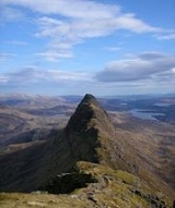
The mountain
forms a steep-sided ridge some 2 km in length. The highest point, known as Caisteal Liath (the Grey Castle in Scottish Gaelic
), lies at the northwest end of this ridge. There are two other summits: Meall Meadhonach (Round Middle Hill) at the central point of the ridge is 723 m high, whilst Meall Beag (Round Little Hill) lies at the southeastern end.
Geologically
, Suilven is formed of Torridonian sandstone, sitting on a landscape of Lewis
ian Gneiss
. As the softer rocks eroded Suilven was left as an Inselberg
, an "island-mountain", hence the prominence of the peak.
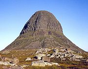
From the coast to the west Suilven looks like a large grey pillar, hence the name which it was given by sea-borne Viking
s. From the inland side the mountain has more of the appearance of a pyramid.
In 2005 Glencanisp estate, of which Suilven forms part and the neighbouring Drumrunie estate, were bought by the local community with the help of the John Muir Trust
. The Assynt
Foundation aims to create local employment and safeguard the natural and cultural heritage for the benefit of the community and future generations, and for the enjoyment of the wider public.
that leads to Glencanisp Lodge, about 1.5 km from Lochinver
to the west of the summit. From here a path leads across undulating moorland toward the mountain, which will be seen clearly ahead. About 6 km after leaving the road, and shortly after crossing Abhainn na Clach Àirigh (a river), a cairn marks the spot where one should leave the path. A boggy path leads towards Suilven, reaching Bealach Mòr (the Great Bealach
) after a little over 2 km. The final pull up to the bealach is steep, and the path is much eroded, but from here the summit is easily attained. The summit itself is broad and grassy, though it is almost totally surrounded by vertical cliffs.
Another route starts from Inverkirkaig, some 4 km south of Lochinver: this route reaches the bealach from the south, passing Kirkaig Falls on the way. One may also start from Elphin, on the eastern side. It is possible to reach the ridge without first climbing to Bealach Mòr from this direction, though very exposed scrambling
is required, particularly between Meall Meadhonach and Meall Beag.
By Scottish standards all routes to Suilven are long days; all are around 25 km in length over rough terrain.
Mountain
Image:Himalaya_annotated.jpg|thumb|right|The Himalayan mountain range with Mount Everestrect 58 14 160 49 Chomo Lonzorect 200 28 335 52 Makalurect 378 24 566 45 Mount Everestrect 188 581 920 656 Tibetan Plateaurect 250 406 340 427 Rong River...
s in Scotland
Scotland
Scotland is a country that is part of the United Kingdom. Occupying the northern third of the island of Great Britain, it shares a border with England to the south and is bounded by the North Sea to the east, the Atlantic Ocean to the north and west, and the North Channel and Irish Sea to the...
. Lying in a remote area in the west of Sutherland
Sutherland
Sutherland is a registration county, lieutenancy area and historic administrative county of Scotland. It is now within the Highland local government area. In Gaelic the area is referred to according to its traditional areas: Dùthaich 'IcAoidh , Asainte , and Cataibh...
, it rises almost vertically from a wilderness
Wilderness
Wilderness or wildland is a natural environment on Earth that has not been significantly modified by human activity. It may also be defined as: "The most intact, undisturbed wild natural areas left on our planet—those last truly wild places that humans do not control and have not developed with...
landscape of moorland
Moorland
Moorland or moor is a type of habitat, in the temperate grasslands, savannas, and shrublands biome, found in upland areas, characterised by low-growing vegetation on acidic soils and heavy fog...
, bog
Bog
A bog, quagmire or mire is a wetland that accumulates acidic peat, a deposit of dead plant material—often mosses or, in Arctic climates, lichens....
s and loch
Loch
Loch is the Irish and Scottish Gaelic word for a lake or a sea inlet. It has been anglicised as lough, although this is pronounced the same way as loch. Some lochs could also be called a firth, fjord, estuary, strait or bay...
ans known as Inverpolly National Nature Reserve.
The mountain
Mountain
Image:Himalaya_annotated.jpg|thumb|right|The Himalayan mountain range with Mount Everestrect 58 14 160 49 Chomo Lonzorect 200 28 335 52 Makalurect 378 24 566 45 Mount Everestrect 188 581 920 656 Tibetan Plateaurect 250 406 340 427 Rong River...
forms a steep-sided ridge some 2 km in length. The highest point, known as Caisteal Liath (the Grey Castle in Scottish Gaelic
Scottish Gaelic language
Scottish Gaelic is a Celtic language native to Scotland. A member of the Goidelic branch of the Celtic languages, Scottish Gaelic, like Modern Irish and Manx, developed out of Middle Irish, and thus descends ultimately from Primitive Irish....
), lies at the northwest end of this ridge. There are two other summits: Meall Meadhonach (Round Middle Hill) at the central point of the ridge is 723 m high, whilst Meall Beag (Round Little Hill) lies at the southeastern end.
Geologically
Geology of the British Isles
Great Britain shows a rich variety of landscape across the constituent countries of England, Wales and Scotland. Landforms and rocks of all geological ages are represented, from Precambrian onwards.- Seismographical results :...
, Suilven is formed of Torridonian sandstone, sitting on a landscape of Lewis
Lewis
Lewis is the northern part of Lewis and Harris, the largest island of the Western Isles or Outer Hebrides of Scotland. The total area of Lewis is ....
ian Gneiss
Gneiss
Gneiss is a common and widely distributed type of rock formed by high-grade regional metamorphic processes from pre-existing formations that were originally either igneous or sedimentary rocks.-Etymology:...
. As the softer rocks eroded Suilven was left as an Inselberg
Monadnock
A monadnock or inselberg is an isolated rock hill, knob, ridge, or small mountain that rises abruptly from a gently sloping or virtually level surrounding plain...
, an "island-mountain", hence the prominence of the peak.
From the coast to the west Suilven looks like a large grey pillar, hence the name which it was given by sea-borne Viking
Viking
The term Viking is customarily used to refer to the Norse explorers, warriors, merchants, and pirates who raided, traded, explored and settled in wide areas of Europe, Asia and the North Atlantic islands from the late 8th to the mid-11th century.These Norsemen used their famed longships to...
s. From the inland side the mountain has more of the appearance of a pyramid.
In 2005 Glencanisp estate, of which Suilven forms part and the neighbouring Drumrunie estate, were bought by the local community with the help of the John Muir Trust
John Muir Trust
The John Muir Trust is a Scottish charity established as a membership organisation in 1983 to conserve wild land and wild places for the benefit of all...
. The Assynt
Assynt
Assynt is a civil parish in west Sutherland, Highland, Scotland – north of Ullapool.It is famous for its landscape and its remarkable mountains...
Foundation aims to create local employment and safeguard the natural and cultural heritage for the benefit of the community and future generations, and for the enjoyment of the wider public.
Ascent
The most common route of ascent starts from the end of the public roadRoad
A road is a thoroughfare, route, or way on land between two places, which typically has been paved or otherwise improved to allow travel by some conveyance, including a horse, cart, or motor vehicle. Roads consist of one, or sometimes two, roadways each with one or more lanes and also any...
that leads to Glencanisp Lodge, about 1.5 km from Lochinver
Lochinver
Lochinver is a village on the coast in the Assynt district of Sutherland, Highland, Scotland. A few miles northeast is Loch Assynt which is the source of the River Inver which flows into Loch Inver at the village. There are 200 or so lochans in the area which makes the place very popular with...
to the west of the summit. From here a path leads across undulating moorland toward the mountain, which will be seen clearly ahead. About 6 km after leaving the road, and shortly after crossing Abhainn na Clach Àirigh (a river), a cairn marks the spot where one should leave the path. A boggy path leads towards Suilven, reaching Bealach Mòr (the Great Bealach
Mountain pass
A mountain pass is a route through a mountain range or over a ridge. If following the lowest possible route, a pass is locally the highest point on that route...
) after a little over 2 km. The final pull up to the bealach is steep, and the path is much eroded, but from here the summit is easily attained. The summit itself is broad and grassy, though it is almost totally surrounded by vertical cliffs.
Another route starts from Inverkirkaig, some 4 km south of Lochinver: this route reaches the bealach from the south, passing Kirkaig Falls on the way. One may also start from Elphin, on the eastern side. It is possible to reach the ridge without first climbing to Bealach Mòr from this direction, though very exposed scrambling
Scrambling
Scrambling is a method of ascending rocky faces and ridges. It is an ambiguous term that lies somewhere between hillwalking and rock climbing. It is often distinguished from hillwalking by defining a scramble as a route where hands must be used in the ascent...
is required, particularly between Meall Meadhonach and Meall Beag.
By Scottish standards all routes to Suilven are long days; all are around 25 km in length over rough terrain.
Gallery
 |
External links
- Computer generated summit panoramas North South index
- Assynt Foundation