
Baleshare
Encyclopedia

Tidal island
A tidal island is a piece of land that is connected to the mainland by a natural or man-made causeway that is exposed at low tide and submerged at high tide. Because of the mystique surrounding tidal islands many of them have been sites of religious worship, such as Mont Saint Michel with its...
in the Outer Hebrides
Outer Hebrides
The Outer Hebrides also known as the Western Isles and the Long Island, is an island chain off the west coast of Scotland. The islands are geographically contiguous with Comhairle nan Eilean Siar, one of the 32 unitary council areas of Scotland...
of Scotland
Scotland
Scotland is a country that is part of the United Kingdom. Occupying the northern third of the island of Great Britain, it shares a border with England to the south and is bounded by the North Sea to the east, the Atlantic Ocean to the north and west, and the North Channel and Irish Sea to the...
.
Baleshare lies to the south-west of North Uist
North Uist
North Uist is an island and community in the Outer Hebrides of Scotland.-Geography:North Uist is the tenth largest Scottish island and the thirteenth largest island surrounding Great Britain. It has an area of , slightly smaller than South Uist. North Uist is connected by causeways to Benbecula...
. Its economics
Economics
Economics is the social science that analyzes the production, distribution, and consumption of goods and services. The term economics comes from the Ancient Greek from + , hence "rules of the house"...
and community were boosted by the building of a causeway
Causeway
In modern usage, a causeway is a road or railway elevated, usually across a broad body of water or wetland.- Etymology :When first used, the word appeared in a form such as “causey way” making clear its derivation from the earlier form “causey”. This word seems to have come from the same source by...
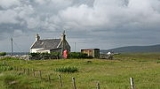
in 1962. The 350m (382 yard) causeway was built by William Tawse Ltd. The island is extremely flat by Hebridean standards, rising to only 12 metres above sea level and known for its long sandy beach
Beach
A beach is a geological landform along the shoreline of an ocean, sea, lake or river. It usually consists of loose particles which are often composed of rock, such as sand, gravel, shingle, pebbles or cobblestones...
. It has a population of 49 living in two settlements: Samhla and Teananachar.
The name means 'east farm' or 'east town'. The 'west town' may have been on land that was said to exist to the west of Baleshare, washed away in the sixteenth century, over which it was possible to walk to the Monach Islands
Monach Islands
Not to be confused with Heysker/Hyskeir or HaskeirThe Monach Islands, also known as Heisker , are an island group west of North Uist in the Outer Hebrides of Scotland...
at low tide. The Monachs are some 15 kilometres to the west. Another story suggests there was once a land bridge to Kirkibost
Kirkibost
Kirkibost is a low-lying island west of North Uist in the Outer Hebrides of Scotland.-Geography:Kirkibost, along with neighbouring Baleshare, is covered by a machair system of coastal plains covered with shell sand, part covered by grass, with some sand dunes, fens and peat. Together with...
, 100 metres to the north. The basis for this seems to be a reference in the Exchequer Rolls for 1542 that the valued rental had been decreased due to encroachment by the sea at some unspecified (presumably recent) date.
Two prehistoric settlements have been uncovered, which contain the remains of a circular stone house and pieces of pottery, bone and metal. In common with other sites in the area, they are threatened by coastal erosion.
Notable people from Baleshare
- John FergussonJohn FergussonJohn Fergusson was a Scottish-born political figure in Nova Scotia. He represented Cape Breton County in the Nova Scotia House of Assembly from 1867 to 1874 as a Liberal member....
, Nova Scotia politician. - Cailean MacQuarrie, Cadet featuring in ITV documentary 'The Merchant Navy'.