
Texas Education Agency
Encyclopedia
Texas
Texas is the second largest U.S. state by both area and population, and the largest state by area in the contiguous United States.The name, based on the Caddo word "Tejas" meaning "friends" or "allies", was applied by the Spanish to the Caddo themselves and to the region of their settlement in...
in the United States
United States
The United States of America is a federal constitutional republic comprising fifty states and a federal district...
responsible for public education
Public education
State schools, also known in the United States and Canada as public schools,In much of the Commonwealth, including Australia, New Zealand, South Africa, and the United Kingdom, the terms 'public education', 'public school' and 'independent school' are used for private schools, that is, schools...
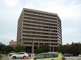
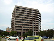
. The agency is headquartered in the William B. Travis State Office Building in Downtown Austin
Downtown Austin
Downtown Austin is the central business district of Austin, Texas. Downtown is located on the north bank of the Colorado River. The approximate borders of Downtown include Lamar Boulevard to the west, 11th Street and sometimes Martin Luther King, Jr...
.
History
Prior to the late 1940s, Texas had many "dormant" school districtSchool district
School districts are a form of special-purpose district which serves to operate the local public primary and secondary schools.-United States:...
s which did not operate schools, but spent money to send children to schools operated by other districts. In the late 1940s state lawmakers passed a bill abolishing those districts, prompting a wave of mass school district consolidation.
Duties
TEA is responsible for the oversight of public primary and secondary education in the state of Texas, involving both the over 1,000 individual school districtSchool district
School districts are a form of special-purpose district which serves to operate the local public primary and secondary schools.-United States:...
s in the state as well as charter school
Charter school
Charter schools are primary or secondary schools that receive public money but are not subject to some of the rules, regulations, and statutes that apply to other public schools in exchange for some type of accountability for producing certain results, which are set forth in each school's charter...
s. However, it does not have any jurisdiction over private
Private school
Private schools, also known as independent schools or nonstate schools, are not administered by local, state or national governments; thus, they retain the right to select their students and are funded in whole or in part by charging their students' tuition, rather than relying on mandatory...
or parochial school
Parochial school
A parochial school is a school that provides religious education in addition to conventional education. In a narrower sense, a parochial school is a Christian grammar school or high school which is part of, and run by, a parish.-United Kingdom:...
s (whether or not accredited) nor over home schools.
Although school districts are independent governmental entities, TEA has the authority to oversee a district's operations (either involving an individual school or the entire district) if serious issues arise (such as poor standardized test performance, financial distress, or reported mismanagement). This can be in the form of requiring the district to submit corrective action plans and regular status reports, assigning monitors to oversee operations (including the authority to assign a management board, which essentially replaces and performs the duties of the elected school board), and in extreme cases closure of a school campus or even the entire school district.
The University Interscholastic League
University Interscholastic League
The University Interscholastic League is an organization that creates rules for and administers almost all athletic, music, and academic contests for public primary and secondary schools in the American state of Texas....
, which oversees academic and athletic interscholastic competition, is a separate entity not under TEA oversight.
In addition to primary and secondary education, TEA has oversight duties with respect to driver's education courses (initial permits) and defensive driving
Defensive driving
The standard Safe Practices for Motor Vehicle Operations, ANSI/ASSE Z15.1, defines defensive driving as "driving to save lives, time, and money, in spite of the conditions around you and the actions of others." This definition is taken from the National Safety Council's Defensive Driving Course...
courses (used to have a ticket dismissed and/or for lower insurance premiums).
Curriculum controversies
On November 7, 2007, Christine ComerChristine Comer
Christine Castillo Comer is the former Director of Science in the curriculum division of the Texas Education Agency . Comer spent nine years as the Director of Science until she resigned on November 7, 2007...
resigned as the director of the science curriculum after more than nine years. Comer said that her resignation was a result of pressure from officials who claimed that she had given the appearance of criticizing the teaching of intelligent design
Intelligent design
Intelligent design is the proposition that "certain features of the universe and of living things are best explained by an intelligent cause, not an undirected process such as natural selection." It is a form of creationism and a contemporary adaptation of the traditional teleological argument for...
.
In 2009, the Board received criticism from more than fifty scientific organizations over an attempt to weaken science standards on evolution
Evolution
Evolution is any change across successive generations in the heritable characteristics of biological populations. Evolutionary processes give rise to diversity at every level of biological organisation, including species, individual organisms and molecules such as DNA and proteins.Life on Earth...
.
In 2010, a group of historians, including Jean A. Stuntz
Jean A. Stuntz
Jean Allison Stuntz is a professor at West Texas A&M University in Canyon, Texas, where she specializes in women's studies and the history of Texas, the Spanish Borderlands, and the American West. She holds the rank of associate professor...
of West Texas A&M University
West Texas A&M University
West Texas A&M University , part of the Texas A&M University System, is a public university located in Canyon, Texas, a small city south of Amarillo. West Texas A&M opened on September 20, 1910...
in Canyon
Canyon, Texas
Canyon is a city in Randall County, Texas, United States. The population was 12,875 at the 2000 census. It is the county seat of Randall County. It is the home of West Texas A&M University and Panhandle-Plains Historical Museum. Palo Duro Canyon State Park is some twelve miles east of Canyon...
, Texas, signed a petition to oppose the revisions in the social studies curricula approved by the state Board, changes which require the inclusion of conservative topics in public school instruction. For instance, Jefferson's name must be restored to a list of Enlightenment
Age of Enlightenment
The Age of Enlightenment was an elite cultural movement of intellectuals in 18th century Europe that sought to mobilize the power of reason in order to reform society and advance knowledge. It promoted intellectual interchange and opposed intolerance and abuses in church and state...
thinkers. There must be emphasis on the Fifth Amendment to the Constitution of the United States in regard to property rights. Students must be taught that new documents, the Venona project
Venona project
The VENONA project was a long-running secret collaboration of the United States and United Kingdom intelligence agencies involving cryptanalysis of messages sent by intelligence agencies of the Soviet Union, the majority during World War II...
, verify U.S. Senator Joseph R. McCarthy's suspicions of communist infiltration of the U.S. government during the post-World War II
World War II
World War II, or the Second World War , was a global conflict lasting from 1939 to 1945, involving most of the world's nations—including all of the great powers—eventually forming two opposing military alliances: the Allies and the Axis...
era. Stuntz told the Amarillo Globe-News
Amarillo Globe-News
Amarillo Globe-News is a newspaper in Amarillo, Texas, owned by the Morris Communications Company.The current-day Globe-News is a combination of several newspapers published in Amarillo. One began on November 4, 1909, as a prohibition publication by the Baptist deacon Dr. Joseph Elbert Nunn...
that the SBOE is "micromanaging. They don't know what they're doing."
Texas House Speaker Joe Straus
Joe Straus
Joseph R. Straus, III, known as Joe Straus , is the current Speaker of the Texas House of Representatives. He represents District 121, which comprises northeastern Bexar County, including part of San Antonio, Texas, and several surrounding communities...
of San Antonio
San Antonio, Texas
San Antonio is the seventh-largest city in the United States of America and the second-largest city within the state of Texas, with a population of 1.33 million. Located in the American Southwest and the south–central part of Texas, the city serves as the seat of Bexar County. In 2011,...
said that the government should "take a look" at the structure of the Board and consider a nonpartisan
Nonpartisan
In political science, nonpartisan denotes an election, event, organization or person in which there is no formally declared association with a political party affiliation....
or appointed board if the elected members are "not getting their job done and they're not pleasing the Legislature or the citizens, then we ought to take a thorough look at what they are doing." In 2010, it was said to be "drafting its own version of American history", including altering school textbooks to remove what it said was a "left leaning bias" and making changes that are said to have "religious and racial overtones".
For example, the proposed curriculum would downplay Thomas Jefferson
Thomas Jefferson
Thomas Jefferson was the principal author of the United States Declaration of Independence and the Statute of Virginia for Religious Freedom , the third President of the United States and founder of the University of Virginia...
's emphasis on the separation of church and state
Separation of church and state
The concept of the separation of church and state refers to the distance in the relationship between organized religion and the nation state....
(outlined in his Letter to Danbury Baptists), and would include a greater emphasis on the importance of religion to the founding fathers. Other changes include downplaying Abraham Lincoln
Abraham Lincoln
Abraham Lincoln was the 16th President of the United States, serving from March 1861 until his assassination in April 1865. He successfully led his country through a great constitutional, military and moral crisis – the American Civil War – preserving the Union, while ending slavery, and...
's role in the civil war and putting more emphasis on the Confederate
Confederate States of America
The Confederate States of America was a government set up from 1861 to 1865 by 11 Southern slave states of the United States of America that had declared their secession from the U.S...
leader Jefferson Davis
Jefferson Davis
Jefferson Finis Davis , also known as Jeff Davis, was an American statesman and leader of the Confederacy during the American Civil War, serving as President for its entire history. He was born in Kentucky to Samuel and Jane Davis...
, questioning the African American Civil Rights Movement in addition to downplaying Martin Luther King Jr.'s legacy, removing such instances and points of history such as downplaying slavery, putting more emphasis on the states rights cause during the Civil War. Critics of the proposed changes believe that such a focus on the religious elements of the founding period could cause teachers to omit lessons on history more pertinent to national standards. Proponents of the new changes argue that the religious elements are often downplayed to the point of obscurity due the left-leaning nature of public education.
State Board of Education
TEA is overseen by a 15-member State Board of Education, elected from single-member districts for four years. TEA is managed by a Commissioner of Education (as of 2007, Robert Scott) who is appointed by the Governor of Texas. The board devises policies and sets academic standards for Texas public schools as well as oversees the $17.5 billion Permanent School Fund and selects textbooks for Texas' 4.7 million schoolchildren.| District | Name | Role | Political Party | Committee | Committee Role |
|---|---|---|---|---|---|
| 1 | Charlie Garza | Republican | School Initiatives | Vice Chair | |
| 2 | Mary Helen Berlanga | Secretary | Democrat | Instruction | |
| 3 | Michael Soto | Democrat | School Initiatives | ||
| 4 | Lawrence A. Allen Jr. | Democrat | School Finance/Permanent School Fund | ||
| 5 | Ken Mercer | Republican | School Initiatives | Chair | |
| 6 | Terri Leo | Republican | Instruction | Vice Chair | |
| 7 | David Bradley | Republican | School Finance/Permanent School Fund | ||
| 8 | Barbara Cargill | Republican | Instruction | Chair | |
| 9 | Thomas Ratliff | Republican | School Finance/Permanent School Fund | ||
| 10 | Marsha Farney | Republican | Instruction | ||
| 11 | Patricia Hardy | Republican | School Finance/Permanent School Fund | Chair | |
| 12 | George Clayton | Republican | Instruction | ||
| 13 | Mavis Knight | Democrat | School Initiatives | ||
| 14 | Gail Lowe | Chair | Republican | School Initiatives | |
| 15 | Bob Craig | Vice Chair | Republican | School Finance/Permanent School Fund |
Regions
In order to serve the large number of individual school districts and charter schools in Texas, TEA is divided into 20 regions, each containing an Educational Service Center (ESC, sometimes called Regional Service Center or RSC). Below are the districts, the cities in which the ESC office is located, and the counties served (districts which overlap counties are served by the ESC for the county in which the district's administrative office is located):- Region 1, EdinburgEdinburg, TexasEdinburg is a city in and the county seat of Hidalgo County, Texas, United States. The population was 77,100 at the 2010 census. The University of Texas–Pan American, the only fully accredited four-year university in the Rio Grande Valley, is located in Edinburg.Edinburg is part of the...
--CameronCameron County, TexasCameron County is the southernmost county located in the U.S. state of Texas. In 2010, its population was 406,220. Its county seat is Brownsville. Cameron was founded in 1848...
, HidalgoHidalgo County, TexasHidalgo County is a county located in the U.S. state of Texas. Located in the Rio Grande Valley of South Texas, Hidalgo County is one of the fastest-growing counties in the United States, and is the seventh most-populous county in Texas. Its population in 2010 was 774,769, a 35% increase from 2000...
, Jim Hogg, StarrStarr County, TexasStarr County is a county located in the U.S. state of Texas. In 2010, its population was 60,968. Its county seat is Rio Grande City. The county is named for James Harper Starr, who served as Secretary of the Treasury of the Republic of Texas. It is part of the Rio Grande City-Roma, TX,...
, WebbWebb County, TexasWebb County is a county located in the U.S. state of Texas. The official 2010 population for the county is 250,304. In 2000, its population was 193,117, and in 2006 its population had been estimated to have reached to 231,470. Its county seat is Laredo...
, Willacy, and Zapata - Region 2, Corpus ChristiCorpus Christi, TexasCorpus Christi is a coastal city in the South Texas region of the U.S. state of Texas. The county seat of Nueces County, it also extends into Aransas, Kleberg, and San Patricio counties. The MSA population in 2008 was 416,376. The population was 305,215 at the 2010 census making it the...
--AransasAransas County, TexasAransas County is a county located in the U.S. state of Texas. It is part of the Corpus Christi Metropolitan Statistical Area. As of 2000, the population was 22,499. Its county seat is Rockport. Aransas County was formed in 1871 from Refugio County.-Geography:According to the U.S...
, BeeBee County, TexasBee County is a county located in the U.S. state of Texas. Bee County was founded December 8, 1857. As of 2010, the population was 31,861. Its county seat is Beeville. Bee County is named for Barnard E...
, Brooks, Duval, Jim WellsJim Wells County, TexasAt the 2000 census, there were 39,326 people, 12,961 households and 10,096 families residing in the county. The population density was 46 per square mile . There were 14,819 housing units at an average density of 17 per square mile...
, Kenedy, Kleberg, Live Oak, McMullen, Nueces, and San Patricio - Region 3, VictoriaVictoria, TexasVictoria is a city in and the seat of Victoria County, Texas, United States. The population was 60,603 at the 2000 census. The three counties of the Victoria Metropolitan Statistical Area had a population of 111,163 at the 2000 census,...
--CalhounCalhoun County, TexasCalhoun County is a county located in the U.S. state of Texas. In 2000, the population was 20,647. Its county seat is Port Lavaca. It is a part of the Victoria Metropolitan Statistical Area...
, Colorado, DeWittDeWitt County, TexasDeWitt County is a county located in the U.S. state of Texas. In 2000, its population was 20,013. DeWitt County is named for Green DeWitt, who founded an early colony in Texas. The seat of the county is Cuero. It was founded in 1846.-Geography:...
, Goliad, Jackson, KarnesKarnes County, TexasKarnes County is a county located in the U.S. state of Texas. As of 2000, the population was 15,446. Its county seat is Karnes City. Karnes County is named for Henry Karnes, a soldier in the Texas Revolution.-Geography:...
, Lavaca, Matagorda, Refugio, VictoriaVictoria County, TexasVictoria County is a county located in the U.S. state of Texas. In 2000, its population was 84,088. Its county seat is Victoria. It is included in the Victoria, Texas Metropolitan Statistical Area.-Geography:According to the U.S...
, and Wharton - Region 4, HoustonHouston, TexasHouston is the fourth-largest city in the United States, and the largest city in the state of Texas. According to the 2010 U.S. Census, the city had a population of 2.1 million people within an area of . Houston is the seat of Harris County and the economic center of , which is the ...
--BrazoriaBrazoria County, TexasBrazoria County[p] is a county in the U.S. state of Texas, located on the Gulf Coast within the Houston–Sugar Land–Baytown metropolitan area. Regionally, parts of the county are within the extreme southern-most fringe of the regions locally known as Southeast Texas. Brazoria County is among a...
, Chambers, Fort BendFort Bend County, TexasFort Bend County is a county located along the Gulf Coast region in the U.S. state of Texas within the Houston–Sugar Land–Baytown metropolitan area. In 2000 its population was 354,452, while the 2010 U.S...
, GalvestonGalveston County, TexasGalveston County is a county located in the U.S. state of Texas within the Houston–Sugar Land–Baytown metropolitan area. As of the 2010 U.S. Census, the population was 291,309. Its county seat is Galveston. League City is the largest city in Galveston County in terms of population; between...
(excluding High IslandHigh Island Independent School DistrictHigh Island Independent School District is a public school district based in unincorporated Galveston County, Texas, United States.HIISD serves the communities of Caplen, High Island, and Gilchrist. The school district lost approximately 15% of its students in 2008 due homes and residences...
, which is served by Region 5), HarrisHarris County, TexasAs of the 2010 Census, the population of the county was 4,092,459, White Americans made up 56.6% of Harris County's population; non-Hispanic whites represented 33.0% of the population. Black Americans made up 18.9% of the population. Native Americans made up 0.7% of Harris County's population...
, LibertyLiberty County, TexasLiberty County is a county located in Texas within the Houston–Sugar Land–Baytown metropolitan area. As of the 2010 United States Census, the population was 75,643. Its county seat is Liberty.-Geography:According to the U.S...
, and Waller - Region 5, BeaumontBeaumont, TexasBeaumont is a city in and county seat of Jefferson County, Texas, United States, within the Beaumont–Port Arthur Metropolitan Statistical Area. The city's population was 118,296 at the 2010 census. With Port Arthur and Orange, it forms the Golden Triangle, a major industrial area on the...
--Galveston (High Island district only; all others are served by Region 4), Hardin, Jasper, JeffersonJefferson County, TexasJefferson County is a county located in the state of Texas, United States. As of 2000, the population was 252,051. Its county seat is Beaumont, and it is named for the former U.S...
, NewtonNewton County, TexasNewton County is the easternmost county in the U.S. state of Texas. In of 2000, its population was 15,072. Its county seat is Newton. Newton county is named for John Newton, a veteran of the American Revolutionary War...
, OrangeOrange County, TexasOrange County is one of 254 counties of the State of Texas and its county seat is the city of Orange, Texas. In the year 2000, the population of Orange County was about 85,000. Orange County is the county in the very southeastern corner of Texas, with a boundary with Louisiana and a seacoast on the...
, and Tyler - Region 6, HuntsvilleHuntsville, TexasHuntsville is a city in and the county seat of Walker County, Texas, United States. The population was 35,508 at the 2010 census. It is the center of the Huntsville micropolitan area....
--AustinAustin County, TexasAustin County is a county located in the U.S. state of Texas adjacent to the Houston–Sugar Land–Baytown metropolitan area. The population was 28,417 at the 2010 census. Its county seat is Bellville. Austin County is named for Stephen F...
, BrazosBrazos County, TexasBrazos County is a county located in the U.S. state of Texas in the Central Texas region. In 2010, its population was 194,851. The county seat is Bryan and it is part of the Bryan-College Station metropolitan area. Brazos is named for the Brazos River, along with Brazoria...
, Burleson, Grimes, HoustonHouston County, TexasHouston County is a county located in the U.S. state of Texas. As of 2000, the population was 23,185. Its county seat is Crockett. Houston County is named for Samuel Houston, a president of the Republic of Texas and Governor of Texas...
, Leon, Madison, Milam, MontgomeryMontgomery County, TexasMontgomery County is a county located in the U.S. state of Texas within the Houston–Sugar Land–Baytown metropolitan area. The county was created by an act of the Congress of the Republic of Texas on December 14, 1837. The county was named for the town of Montgomery, Texas. In 2000, its...
, Polk, Robertson, San Jacinto, Trinity, WalkerWalker County, TexasWalker County is a county located in the U.S. state of Texas. In 2010, its population was 67,861. Its county seat is Huntsville.Initially, Walker County was named for Robert J. Walker, a legislator from Mississippi who introduced into the United States Congress the resolution to annex Texas...
, and Washington - Region 7, KilgoreKilgore, TexasKilgore is a city in Gregg and Rusk Counties in the eastern part of the U.S. state of Texas. It is the home of Kilgore College, and was also the childhood home of famous classical pianist Van Cliburn...
--AndersonAnderson County, TexasAnderson County is a county located in the U.S. state of Texas. As of 2000, the population was 55,109. Its county seat is Palestine. Anderson county was organized in 1846, and is named in honor of Kenneth L. Anderson who had been Vice President of the Republic of Texas.-Geography:According to the...
, AngelinaAngelina County, TexasAngelina County is a county located in the U.S. state of Texas. Angelina County was formed in 1846 from Nacogdoches County. As of 2000, the population was 80,130. Its county seat is Lufkin. Angelina is named for a Hainai Native American woman who assisted early Spanish missionaries and was named...
, CherokeeCherokee County, TexasAs of the census of 2000, there were 46,659 people, 16,651 households, and 12,105 families residing in the county. The population density was 44 people per square mile . There were 19,173 housing units at an average density of 18 per square mile...
, GreggGregg County, TexasThere were 42,687 households out of which 33.50% had children under the age of 18 living with them, 52.00% were married couples living together, 13.50% had a female householder with no husband present, and 30.50% were non-families. 26.10% of all households were made up of individuals and 10.50% had...
, HarrisonHarrison County, TexasHarrison County is a county of the U.S. state of Texas. In 2000, its population was 62,110. It is named for Jonas Harrison, a lawyer and Texas revolutionary. It is located in the Ark-La-Tex region...
, HendersonHenderson County, TexasAs of the census of 2000, there were 73,277 people, 28,804 households, and 20,969 families residing in the county. The population density was 84 people per square mile . There were 35,935 housing units at an average density of 41 per square mile...
, NacogdochesNacogdoches County, TexasAs of the census of 2000, there were 59,203 people, 22,006 households, and 14,039 families residing in the county. The population density was 62 people per square mile . There were 25,051 housing units at an average density of 26 per square mile...
, PanolaPanola County, TexasAs of the census of 2000, there were 22,756 people, 8,821 households, and 6,395 families residing in the county. The population density was 28 people per square mile . There were 10,524 housing units at an average density of 13 per square mile...
, RainsRains County, Texas*Alba*East Tawakoni*Emory*Point*Dougherty-See also:*National Register of Historic Places listings in Rains County, Texas-External links:*...
, RuskRusk County, TexasAs of the census of 2000, there were 47,372 people, 17,364 households, and 12,727 families residing in the county. The population density was 51 people per square mile . There were 19,867 housing units at an average density of 22 per square mile...
, Sabine, San AugustineSan Augustine County, TexasAs of the census of 2000, there were 8,946 people, 3,575 households, and 2,520 families residing in the county. The population density was 17 people per square mile . There were 5,356 housing units at an average density of 10 per square mile...
, ShelbyShelby County, Texas*Arcadia*Brooklyn*Center*Dreka *Huxley*Joaquin*Possum Trot*Shelbyville *Tenaha*Timpson*Weaver-Education:The following school districts serve Shelby County:*Center ISD*Excelsior ISD...
, SmithSmith County, TexasAs of the census of 2000, there were 174,706 people, 65,692 households, and 46,904 families residing in the county. The population density was 188 people per square mile . There were 71,701 housing units at an average density of 77 per square mile...
, UpshurUpshur County, TexasAs of the census of 2000, there were 35,291 people, 13,290 households, and 10,033 families residing in the county. The population density was 60 people per square mile . There were 14,930 housing units at an average density of 25 per square mile...
, Van ZandtVan Zandt County, TexasAs of the census of 2000, there were 48,140 people, 18,195 households, and 13,664 families residing in the county. The population density was 57 people per square mile . There were 20,896 housing units at an average density of 25 per square mile...
(excluding CantonCanton Independent School DistrictCanton Independent School District is a public school district based in Canton, Texas .There are four campuses in Canton ISD - Canton High , Canton Middle , Canton Intermediate , and Canton Elementary ....
and Wills PointWills Point Independent School DistrictWills Point Independent School District is a school district based in Wills Point, Texas and covering all of the city of Wills Point as well as the communities of Hiram, Myrtle Springs, Scott, Elwood, Cobb, Frog, Elmo, and the surrounding unincorporated areas in both Van Zandt and Kaufman...
districts, which are served by Region 10), and WoodWood County, TexasAs of the census of 2000, there were 36,752 people, 14,583 households, and 10,645 families residing in the county. The population density was 56 people per square mile . There were 17,939 housing units at an average density of 28 per square mile... - Region 8, Mount PleasantMount Pleasant, TexasMount Pleasant is the county seat and largest city of Titus County in the U.S. state of Texas. As of the 2000 census, Mount Pleasant's population was 13,935. It is the county seat of Titus County, and is situated in Northeast Texas. This town, by city ordinance, is dry to sell alcoholic beverages....
--BowieBowie County, TexasBowie County is a county located in the U.S. state of Texas. It is part of the Texarkana, Texas - Texarkana, Arkansas, Metropolitan Statistical Area. As of 2000, the population was 89,306. Its legal county seat is Boston, though its courthouse is located in New Boston...
, CampCamp County, TexasAs of the census of 2000, there were 11,549 people, 4,336 households, and 3,156 families residing in the county. The population density was 58 people per square mile . There were 5,228 housing units at an average density of 26 per square mile...
, CassCass County, TexasAs of the census of 2000, there were 30,438 people, 12,190 households, and 8,654 families residing in the county. The population density was 32 people per square mile . There were 13,890 housing units at an average density of 15 per square mile...
, Delta, FranklinFranklin County, TexasAs of the census of 2000, there were 9,458 people, 3,754 households, and 2,732 families residing in the county. The population density was 33 people per square mile . There were 5,132 housing units at an average density of 18 per square mile...
, HopkinsHopkins County, Texas*Brashear*Dike*Como*Cumby*Gafford*Pickton*Saltillo*Sulphur Bluff*Sulphur Springs*Tira-See also:*National Register of Historic Places listings in Hopkins County, Texas-External links:*...
, Lamar, MarionMarion County, TexasAs of the census of 2000, there were 10,941 people, 4,610 households, and 3,120 families residing in the county. The population density was 29 people per square mile . There were 6,384 housing units at an average density of 17 per square mile...
, MorrisMorris County, TexasAs of the census of 2000, there were 13,048 people, 5,215 households, and 3,749 families residing in the county. The population density was 51 people per square mile . There were 6,017 housing units at an average density of 24 per square mile...
, Red River, and TitusTitus County, TexasAs of the census of 2000, there were 28,118 people, 9,552 households, and 7,154 families residing in the county. The population density was 68 people per square mile . There were 10,675 housing units at an average density of 26 per square mile... - Region 9, Wichita FallsWichita Falls, TexasWichita Falls is a city in and the county seat of Wichita County, Texas, United States, United States. Wichita Falls is the principal city of the Wichita Falls Metropolitan Statistical Area, which encompasses all of Archer, Clay and Wichita counties. According to the U.S. Census estimate of 2010,...
--ArcherArcher County, TexasArcher County is a county located in the US state of Texas, and was formed in 1858 from Fannin County. It is part of the Wichita Falls, Texas, Metropolitan Statistical Area. As of 2005, the population estimate is 9,095, up from 8,854 in 2000. Its county seat is Archer City. Archer is named for...
, BaylorBaylor County, TexasAs of the census of 2000, there were 4,093 people, 1,791 households, and 1,156 families residing in the county. The population density was 5 people per square mile . There were 2,820 housing units at an average density of 3 per square mile...
, ClayClay County, TexasAs of the census of 2000, there were 11,006 people, 4,323 households, and 3,181 families residing in the county. The population density was 10 people per square mile . There were 4,992 housing units at an average density of 4 per square mile...
, FoardFoard County, TexasAs of the census of 2000, there were 1,622 people, 664 households, and 438 families residing in the county. The population density was 2 people per square mile . There were 850 housing units at an average density of 1 per square mile...
, HardemanHardeman County, TexasAs of the census of 2000, there were 4,724 people, 1,943 households, and 1,319 families residing in the county. The population density was 7 people per square mile . There were 2,358 housing units at an average density of 3 per square mile...
, JackJack County, Texas*Bryson*Jacksboro*Jermyn *Joplin *Perrin *Gibtown-See also:*National Register of Historic Places listings in Jack County, Texas-External links:*...
, KnoxKnox County, TexasAs of the census of 2000, there were 4,253 people, 1,690 households, and 1,166 families residing in the county. The population density was 5 people per square mile . There were 2,129 housing units at an average density of 2 per square mile...
, MontagueMontague County, TexasAs of the census of 2000, there were 19,117 people, 7,770 households, and 5,485 families residing in the county. The population density was 20 people per square mile . There were 9,862 housing units at an average density of 11 per square mile...
, ThrockmortonThrockmorton County, Texas-2010 census:As of the census of 2010, there were 1,641 people. There were 1,079 housing units, 358 of which were vacant. The racial makeup of the county was 94.8% White , 0.1% Black or African American , 0.7% Native American , 0.4% Asian , 2.6% from other races , and 0.8% from two or more races...
, WichitaWichita County, TexasAs of the census of 2000, there were 131,664 people, 48,441 households, and 32,891 families residing in the county. The population density was 210 people per square mile . There were 53,304 housing units at an average density of 85 per square mile...
, WilbargerWilbarger County, Texas*Harrold *Odell *Oklaunion *Vernon-Notable natives and residents:*Jack English Hightower, Memphis, Texas, native; former member of both houses of the Texas State Legislature, and former U.S...
, and YoungYoung County, TexasAs of the census of 2000, there were 17,943 people, 7,167 households, and 5,081 families residing in the county. The population density was 20 people per square mile . There were 8,504 housing units at an average density of 9 per square mile... - Region 10, RichardsonRichardson, TexasRichardson is a city in Dallas and Collin Counties in the U.S. state of Texas. As of the 2010 census, the city had a total population of 99,223. In 2011 the population was estimated to be 107,684. Richardson is an affluent inner suburb of Dallas and home of the Telecom Corridor with a high...
--CollinCollin County, TexasAs of the census of 2000, there were 491,675 people, 181,970 households, and 132,292 families residing in the county. The population density was 580 people per square mile . There were 194,892 housing units at an average density of 230 per square mile...
, DallasDallas County, TexasAs of the census of 2000, there were 2,218,899 people, 807,621 households, and 533,837 families residing in the county. The population density was 2,523 people per square mile . There were 854,119 housing units at an average density of 971/sq mi...
, EllisEllis County, TexasAs of the census of 2000, there were 111,360 people, 37,020 households, and 29,653 families residing in the county. The population density was 118 people per square mile . There were 39,071 housing units at an average density of 42 per square mile...
, FanninFannin County, TexasAs of the census of 2000, there were 31,242 people, 11,105 households, and 7,984 families residing in the county. The population density was 35 people per square mile . There were 12,887 housing units at an average density of 14 per square mile...
, GraysonGrayson County, TexasAs of the census of 2000, there were 110,595 people, 42,849 households, and 30,208 families residing in the county. The population density was 118 people per square mile . There were 48,315 housing units at an average density of 52 per square mile...
, HuntHunt County, TexasAs of the census of 2000, there were 76,596 people, 28,742 households, and 20,521 families residing in the county. The population density was 91 people per square mile . There were 32,490 housing units at an average density of 39 per square mile...
, KaufmanKaufman County, TexasAs of the census of 2000, there were 71,313 people, 24,367 households, and 19,225 families residing in the county. The population density was 91/sq mi . There were 26,133 housing units at an average density of 33/sq mi...
, RockwallRockwall County, TexasAs of the census of 2000, there were 43,080 people, 14,530 households, and 11,972 families residing in the county. The population density was 334 people per square mile . There were 15,351 housing units at an average density of 119 per square mile...
, and Van ZandtVan Zandt County, TexasAs of the census of 2000, there were 48,140 people, 18,195 households, and 13,664 families residing in the county. The population density was 57 people per square mile . There were 20,896 housing units at an average density of 25 per square mile...
(Canton and Wills Point districts only; all others are served by Region 7) - Region 11, Fort WorthFort Worth, TexasFort Worth is the 16th-largest city in the United States of America and the fifth-largest city in the state of Texas. Located in North Central Texas, just southeast of the Texas Panhandle, the city is a cultural gateway into the American West and covers nearly in Tarrant, Parker, Denton, and...
--CookeCooke County, TexasAs of the census of 2000, there were 36,363 people, 13,643 households, and 10,000 families residing in the county. The population density was 42 people per square mile . There were 15,061 housing units at an average density of 17 per square mile...
, DentonDenton County, TexasDenton County is a county located in the U.S. state of Texas. In 2000, its population was 432,976; in 2009 the estimated population had reached 628,300. Part of the Dallas – Fort Worth Metroplex, it is one of the fastest-growing counties in the United States. The county seat is Denton. The county...
, ErathErath County, TexasErath County is a county located on the Edwards Plateau in the U.S. state of Texas. In 2000, its population was 33,001. It is named for George Bernard Erath, an early surveyor and a soldier at the Battle of San Jacinto. The seat of the county is Stephenville....
, Hood, JohnsonJohnson County, TexasAs of the census of 2000, there were 126,811 people, 43,636 households, and 34,428 families residing in the county. The population density was 174 people per square mile . There were 46,269 housing units at an average density of 63 per square mile...
, ParkerParker County, TexasAs of the census of 2003, there were 98,495 people, 31,131 households, and 24,313 families residing in the county. The population density was 98 people per square mile . There were 34,084 housing units at an average density of 38 per square mile...
, Palo PintoPalo Pinto County, TexasAs of the census of 2000, there were 27,026 people, 10,594 households, and 7,447 families residing in the county. The population density was 28 people per square mile . There were 14,102 housing units at an average density of 15 per square mile...
, SomervellSomervell County, TexasThere were 2,438 households out of which 37.40% had children under the age of 18 living with them, 61.70% were married couples living together, 9.60% had a female householder with no husband present, and 24.50% were non-families. 21.30% of all households were made up of individuals and 9.20% had...
, TarrantTarrant County, TexasTarrant County is a county located in the U.S. state of Texas. As of the 2010 U.S. Census, it had a population of 1,809,034. Its county seat is Fort Worth. Tarrant County is the sixteenth most populous county in the United States and the third most populous in Texas. The county is named in honor...
, and WiseWise County, TexasAs of the census of 2000, there were 48,793 people, 17,178 households, and 13,467 families residing in the county. The population density was 54 people per square mile . There were 19,242 housing units at an average density of 21 per square mile... - Region 12, WacoWaco, TexasWaco is a city in and the county seat of McLennan County, Texas. Situated along the Brazos River and on the I-35 corridor, halfway between Dallas and Austin, it is the economic, cultural, and academic center of the 'Heart of Texas' region....
--BellBell County, TexasBell County is a county located in the U.S. state of Texas. Bell County was founded in 1850. It is part of the Killeen–Temple–Fort Hood Metropolitan Statistical Area. In 2000, the county's population was 237,974; in 2010 the U.S. Census Bureau reported that its population had reached...
, BosqueBosque County, TexasBosque County is a county located on the Edwards Plateau in the U.S. state of Texas. As of 2000, the population is 17,204. Its county seat is Meridian. Clifton, however, is the largest city and the cultural/financial center of the county. Bosque is named for the Bosque River, which runs through...
, CoryellCoryell County, TexasCoryell County is a county located on the Edwards Plateau in the U.S. state of Texas. In 2000, its population was 74,978. The county seat is Gatesville. Coryell County forms part of the Killeen–Temple–Fort Hood Metropolitan Statistical Area...
, FallsFalls County, TexasFalls County is a county located in the U.S. state of Texas. In 2000, its population was 18,576. In 2003, the population of the county was estimated to be 17,926. It is named for the waterfalls on the Brazos River, which can be found at the Falls On The Brazos Park, a campsite located only a few...
, FreestoneFreestone County, TexasFreestone County is a county located in the U.S. state of Texas. As of 2000, the population was 17,867. Its county seat is Fairfield.-Geography:...
, Hamilton, Hill, LampasasLampasas County, TexasLampasas County is a county located on the Edwards Plateau in the U.S. state of Texas. In 2000, its population was 17,762. Its seat is Lampasas. The county is named for the Lampasas River....
, LimestoneLimestone County, TexasLimestone County is a county located in the U.S. state of Texas. As of 2000, the population was 22,051. Its county seat is Groesbeck.-Geography:According to the U.S. Census Bureau, the county has a total area of , of which is land and is water....
, McLennanMcLennan County, TexasMcLennan County is a county located on the Edwards Plateau in Central Texas. In 2000, its population was 213,517; in 2008 the U.S. Census Bureau estimated its population to be 230,213. Its seat is Waco. The county is named for Neil McLennan, an early settler....
, MillsMills County, TexasMills County is a county located on the Edwards Plateau in Central Texas. In 2000, its population was 5,151. Mills County is named for John T. Mills, a justice of the Texas Supreme Court...
, and Navarro - Region 13, AustinAustin, TexasAustin is the capital city of the U.S. state of :Texas and the seat of Travis County. Located in Central Texas on the eastern edge of the American Southwest, it is the fourth-largest city in Texas and the 14th most populous city in the United States. It was the third-fastest-growing large city in...
--BastropBastrop County, TexasBastrop County is a county located in the U.S. state of Texas. As of 2006, the population was 71,700. Its county seat is Bastrop. Bastrop County is named for Felipe Enrique Neri, Baron de Bastrop , an early Dutch settler who assisted Stephen F...
, BlancoBlanco County, TexasBlanco County is a county located on the Edwards Plateau in the U.S. state of Texas. As of 2010, the population is 10,497. Its county seat is Johnson City. Blanco is named for the Blanco River which traverses the county. The State of Texas formed Blanco County in 1858 from portions of Burnet,...
, BurnetBurnet County, TexasBurnet County is a county located on the Edwards Plateau in the U.S. state of Texas. As of 2000, the population was 34,147. The 2008 Census Bureau Estimate was 44,488. Its county seat is Burnet. Burnet is named for David Gouverneur Burnet, the first president of the Republic of Texas...
, CaldwellCaldwell County, TexasCaldwell County is a county located in the U.S. state of Texas. It is part of the Austin-Round Rock metropolitan area. In 2000, the population was 32,194. Its county seat is Lockhart...
, ComalComal County, TexasComal County is a county located on the Edwards Plateau in the U.S. state of Texas. In 2010, its population was 108,472. Its seat is New Braunfels.Comal County is part of the San Antonio Metropolitan Statistical Area.-History Timeline:...
, FayetteFayette County, TexasFayette County is a county located in the U.S. state of Texas. As of 2000, the population was 21,804. Its county seat is La Grange. Fayette is named for the Marquis de la Fayette, a French nobleman who became an American Revolutionary War hero...
, GillespieGillespie County, TexasGillespie County is a county located on the Edwards Plateau in the U.S. state of Texas. In 2010, its population was 24,837. It is located in the heart of the Texas Hill Country. Gillespie is named for Robert Addison Gillespie, who came to Texas in 1837. He was a Texas Ranger, an Indian fighter, a...
, GonzalesGonzales County, TexasGonzales County is a county located in the U.S. state of Texas. In 2000, its population was 18,628. It is named for its seat, the city of Gonzales.-History Timeline:* Paleo-Indians Hunter-gatherers, and later Coahuiltecan, Tonkawa, Karankawa...
, GuadalupeGuadalupe County, TexasGuadalupe County is a county located in the U.S. state of Texas. In 2000, its population was 89,023. It is named for the Guadalupe River. The seat of the county is Seguin. It was founded in 1846....
, HaysHays County, TexasHays County is a county located on the Edwards Plateau in the U.S. state of Texas. In 2010, its official population had reached 157,107. It is named for John Coffee Hays, a Texas Ranger and Mexican-American War officer. The seat of the county is San Marcos....
, KendallKendall County, TexasKendall County is a county located on the Edwards Plateau in the U.S. state of Texas. In 2008 census, its population was 32,886. Its seat is Boerne....
, Lee, LlanoLlano County, TexasLlano County is a county located on the Edwards Plateau in the U.S. state of Texas. In 2010, its population was 19, 301. Its county seat is Llano, and the county is named for the Llano River....
, Milam, TravisTravis County, TexasAs of 2009, the U.S. census estimates there were 1,026,158 people, 320,766 households, and 183,798 families residing in the county. The population density was 821 people per square mile . There were 335,881 housing units at an average density of 340 per square mile...
, and WilliamsonWilliamson County, TexasWilliamson County is a county located on both the Edwards Plateau to the west, consisting of rocky terrain and hills, and Blackland Prairies in the east consising of rich, fertile farming land, The two areas are roughly bisected by Interstate 35... - Region 14, AbileneAbilene, TexasAbilene is a city in Taylor and Jones counties in west central Texas. The population was 117,063 at the 2010 census. It is the principal city of the Abilene Metropolitan Statistical Area, which had a 2006 estimated population of 158,063. It is the county seat of Taylor County...
--CallahanCallahan County, Texas*Baird*Belle Plain*Callahan City*Clyde*Cottonwood*Cross Plains*Eula*Putnam-See also:*National Register of Historic Places listings in Callahan County, Texas-External links:* at the University of Texas*...
, ComancheComanche County, TexasComanche County is a county located on the Edwards Plateau in Central Texas. In 2000, its population was 14,026. Comanche was founded in 1856. Comanche is named for the Comanche Native American tribe...
, EastlandEastland County, Texas*Carbon*Cisco*Desdemona, a ghost town*Eastland*Gorman*Mangum*Olden*Ranger*Rising Star*Romney-See also:*National Register of Historic Places listings in Eastland County, Texas*Santa Claus Bank Robbery-External links:** at the University of Texas*...
, Fisher, HaskellHaskell County, TexasAs of the census of 2000, 6,093 people, 2,569 households, and 1,775 families resided in the county. The population density was 7 people per square mile . There were 3,555 housing units at an average density of 4 per square mile...
, JonesJones County, TexasAs of the census of 2000, there were 20,785 people, 6,140 households, and 4,525 families residing in the county. The population density was 22 people per square mile . There were 7,236 housing units at an average density of 8 per square mile...
, Mitchell, Nolan, Scurry, ShackelfordShackelford County, TexasAs of the census of 2000, there were 3,302 people, 1,300 households, and 941 families residing in the county. The population density was 4 people per square mile . There were 1,613 housing units at an average density of 2 per square mile...
, StephensStephens County, TexasAs of the census of 2000, there were 9,674 people, 3,661 households, and 2,591 families residing in the county. The population density was 11 people per square mile . There were 4,893 housing units at an average density of 6 per square mile...
, Stonewall, and TaylorTaylor County, TexasAs of the census of 2000, there were 126,555 people, 47,274 households, and 32,524 families residing in the county. The population density was 138 people per square mile . There were 52,056 housing units at an average density of 57 per square mile... - Region 15, San AngeloSan Angelo, TexasSan Angelo is a city in the state of Texas. Located in West Central Texas it is the county seat of Tom Green County. As of 2010 according to the United States Census Bureau, the city had a total population of 93,200...
--BrownBrown County, TexasBrown County is a county in West Central Texas. As of 2000, the population was 37,674. Its county seat is Brownwood. Brown is named for Henry Stevenson Brown, a commander at the Battle of Velasco...
, Coke, Coleman, Concho, Crockett, Edwards, Irion, KimbleKimble County, TexasKimble County is a county located on the Edwards Plateau in the U.S. state of Texas. In 2000, its population was 4,468. Its county seat is Junction. Kimble is named for George C. Kimble, who died at the Battle of the Alamo.-Geography:...
, MasonMason County, TexasMason County is a county located on the Edwards Plateau in the U.S. state of Texas. In 2010, its population was 4, 012. Its county seat is Mason...
, McCullochMcCulloch County, TexasMcCulloch County is a county located on the Edwards Plateau in the U.S. state of Texas. The geographical center of Texas lies within the county. In 2000, its population was 8,205. Its county seat is Brady. McCulloch is named for Benjamin McCulloch, a famous Texas Ranger and Confederate...
, Menard, Runnels, San SabaSan Saba County, TexasSan Saba County is a county located on the Edwards Plateau in Western Central Texas. In 2010, its population was 6,131. Its county seat is San Saba. It is named for the San Saba River, which flows through the county.-History:...
, Schleicher, SterlingSterling County, TexasSterling County is a county located on the Edwards Plateau in the U.S. state of Texas. In 2000, its population was 1,393. Its county seat is Sterling City. The county is named for W. S. Sterling, an early settler in the area. Sterling County is one of 30 prohibition, or entirely dry, counties in...
, Sutton, Tom Green, and Val VerdeVal Verde County, TexasVal Verde County is a county located on the Edwards Plateau in the U.S. state of Texas. In 2008, estimated population was 55,000. Its county seat is Del Rio. In 1936, Val Verde County received Recorded Texas Historic Landmark number 5625 to commemorate its founding.Val Verde, which means "green... - Region 16, AmarilloAmarillo, TexasAmarillo is the 14th-largest city, by population, in the state of Texas, the largest in the Texas Panhandle, and the seat of Potter County. A portion of the city extends into Randall County. The population was 190,695 at the 2010 census...
--ArmstrongArmstrong County, TexasArmstrong County is a county located in the U.S. state of Texas, and was formed in 1876 from Bexar County. It is part of the Amarillo metropolitan area. As of 2000, the population is 2,148. Its county seat is Claude. Armstrong is named for one of several Texas pioneer families named Armstrong...
, Briscoe, CarsonCarson County, TexasCarson County is a county located in the U.S. state of Texas. It is part of the Amarillo metropolitan area. In 2000, its population was 6,516. Carson is named for Samuel Price Carson, the first secretary of state of the Republic of Texas. The seat of the county is Panhandle. It was founded in...
, Castro, Childress, Collingsworth, Dallam, Deaf Smith, DonleyDonley County, TexasDonley County is a county located in the U.S. state of Texas. In 2000, its population was 3,828. It is named for Stockton P. Donley, a frontier lawyer. Its county seat is Clarendon....
, Gray, Hall, HansfordHansford County, TexasHansford County is a county located in the U.S. state of Texas. In 2010, its population was 5,613. The county is named for John M. Hansford, a Texas state congressman and judge. Hansford County is one of 30 prohibition, or entirely dry, counties in the state of Texas. Its seat is...
, Hartley, Hemphill, HutchinsonHutchinson County, TexasHutchinson County is a county located in the U.S. state of Texas in the northern portion of the Texas Panhandle. In 2000, its population was 23,857. Its seat is Stinnett . Hutchinson County is named for Andrew Hutchinson, an early Texas attorney....
, Lipscomb, Moore, Ochiltree, Oldham, Parmer, Potter, Randall, Roberts, Sherman, SwisherSwisher County, TexasSwisher County is a county located in the U.S. state of Texas. In 2000, its population was 8,378. Its seat is Tulia. The county is named for James G. Swisher, a soldier of the Texas Revolution and signer of the Texas Declaration of Independence...
, and Wheeler - Region 17, LubbockLubbock, TexasLubbock is a city in and the county seat of Lubbock County, Texas, United States. The city is located in the northwestern part of the state, a region known historically as the Llano Estacado, and the home of Texas Tech University and Lubbock Christian University...
--BaileyBailey County, TexasBailey County is a county located in the U.S. state of Texas. As of 2010, the population is 7,165. Its county seat is Muleshoe. Bailey is named for Peter James Bailey, a defender of the Alamo...
, BordenBorden County, TexasBorden County is a rural county located in the U.S. state of Texas. In 2000, its population was 729. Its county seat is Gail. Gail and Borden County are named for Gail Borden, Jr., businessman, publisher, surveyor, and inventor of condensed milk...
, Cochran, Cottle, Crosby, Dawson, Dickens, Floyd, Gaines, GarzaGarza County, TexasGarza County is a county located in the U.S. state of Texas southeast of Lubbock. In 2000, its population was 4,872. Its county seat is Post. Garza is named for a pioneer Bexar County family, as it was once a part of that county....
, HaleHale County, TexasHale County is a county located in the U.S. state of Texas. In 2000, its population was 36,602. It was organized in 1888, and is named for Lt. John C. Hale, a hero of the Battle of San Jacinto. The seat of the county is Plainview. It is home of the noted former Hale County Judge, Judge Bill...
, Hockley, Kent, King, Lamb, Lubbock, Lynn, Motley, Terry, and Yoakum. - Region 18, MidlandMidland, TexasMidland is a city in and the county seat of Midland County, Texas, United States, on the Southern Plains of the state's western area. A small portion of the city extends into Martin County. As of 2010, the population of Midland was 111,147. It is the principal city of the Midland, Texas...
--Andrews, BrewsterBrewster County, TexasBrewster County is a county located in western part of the US state of Texas, along the border with Mexico. It is one of the nine counties that comprise the Trans-Pecos region of West Texas. As of the 2000 census, the population is 8,866. In 2009, the population was estimated to be 9,481. Its...
, Crane, CulbersonCulberson County, TexasCulberson County is a county located in the U.S. state of Texas. It is one of the nine counties that comprise the Trans-Pecos region of West Texas. In 2000, its population was 2,975. Culberson was founded in 1911. It is named for David B. Culberson, a lawyer and Confederate soldier in the American...
, Ector, Glasscock, Howard, Jeff DavisJeff Davis County, TexasJeff Davis County is a county in the U.S. state of Texas. It is named for Jefferson Davis, the president of the Confederate States of America. It is one of the nine counties that comprise the Trans-Pecos region of West Texas. In 2000, its population was 2,207, and 2,258 by 2009...
, LovingLoving County, TexasUS Census 2000Of the 67 residents, 60 were White, 6 of "some other race", and 1 person of two or more races. There were 7 residents who were Hispanic or Latino of any race...
, Martin, Midland, PecosPecos County, TexasPecos County is a county located in Texas which is named for the Pecos River. It is one of the nine counties that comprise the Trans-Pecos region of West Texas. In 2000, its population was 16,809. The county seat is Fort Stockton....
, PresidioPresidio County, TexasPresidio County is a county located in the U.S. state of Texas. In 2000, its population was 7,304. Its county seat is Marfa. Presidio County is in the Trans-Pecos region of West Texas and is named for the ancient border settlement of Presidio del Norte.-Geography:Presidio County is triangular in...
, ReaganReagan County, TexasReagan County is a county located on the Edwards Plateau in the U.S. state of Texas. In 2000, its population was 3,326. The seat of the county is Big Lake. It is named in honor of John Henninger Reagan , who served as postmaster general of the Confederate States of America and also as a U.S....
, ReevesReeves County, TexasReeves County is a county located in the US state of Texas. It is one of the nine counties that comprise the Trans-Pecos region of West Texas. In 2000, its population was 13,137. Its seat is Pecos. Reeves County is named for George R. Reeves, a Texas state legislator and colonel in the...
, TerrellTerrell County, TexasTerrell County is a county located in the U.S. state of Texas. It is one of the nine counties that comprise the Trans-Pecos region of West Texas. In 2000, its population was 1,081. Its county seat is Sanderson. The county was named for Alexander W. Terrell, a Texas state senator...
, UptonUpton County, TexasUpton County is a county located on the Edwards Plateau in the U.S. state of Texas. In 2000, its population was 3,404. Its county seat is Rankin. The county is named for two brothers: John C. and William F. Upton, both Colonels in the Confederate army....
, Ward, and WinklerWinkler County, TexasWinkler County is a county located in the U.S. state of Texas. In 2000, its population was 7,173. Its county seat is Kermit. The county is named for Clinton M. Winkler, a Colonel in the Confederate Army.... - Region 19, El PasoEl Paso, TexasEl Paso, is a city in and the county seat of El Paso County, Texas, United States, and lies in far West Texas. In the 2010 census, the city had a population of 649,121. It is the sixth largest city in Texas and the 19th largest city in the United States...
--El Paso and HudspethHudspeth County, TexasHudspeth County is a county located in the U.S. state of Texas. It is one of the nine counties that comprise the Trans-Pecos region of West Texas. As of 2000, the population was 3,344. By 2010, the population had increased to 3,476. Its county seat is Sierra Blanca. The largest city is Fort Hancock... - Region 20, San AntonioSan Antonio, TexasSan Antonio is the seventh-largest city in the United States of America and the second-largest city within the state of Texas, with a population of 1.33 million. Located in the American Southwest and the south–central part of Texas, the city serves as the seat of Bexar County. In 2011,...
--Atascosa, BanderaBandera County, TexasBandera County, formed in 1856 from Bexar and Uvalde counties, is a county located on the Edwards Plateau in the U.S. state of Texas. As of 2000, the population is 17,645. Its county seat is Bandera. Bandera is named for the Spanish word for flag...
, BexarBexar County, TexasAs of the census of 2000, there were 1,392,931 people, 488,942 households, and 345,681 families residing in the county. The population density was 1,117 people per square mile . There were 521,359 housing units at an average density of 418 per square mile...
, DimmitDimmit County, TexasDimmit County is a county located in the U.S. state of Texas. In 2000, its population was 10,248. It is named for Philip Dimmitt, a major figure in the Texas Revolution. The reason the county name differs is because the bill creating the county misspelled Dimmitt's name...
, Frio, KendallKendall County, TexasKendall County is a county located on the Edwards Plateau in the U.S. state of Texas. In 2008 census, its population was 32,886. Its seat is Boerne....
, KerrKerr County, TexasKerr County is a county located on the Edwards Plateau in the U.S. state of Texas. In 2010, its population was 49,625. Its county seat is Kerrville. Kerr County was named by Joshua D. Brown for his fellow Kentucky native, James Kerr, a congressman of the Republic of Texas...
, KinneyKinney County, TexasKinney County is a county located in the U.S. state of Texas. In 2000, its population was 3,379. Its seat is Brackettville. Kinney County is named for Henry Lawrence Kinney, an early settler.-Geography:...
, La Salle, MaverickMaverick County, TexasMaverick County is a county located in the U.S. state of Texas. In 2000, its population was 47,297. Its county seat is Eagle Pass. Maverick County is named for Samuel Maverick, cattleman and state legislator....
, Medina, Real, UvaldeUvalde County, TexasUvalde County is a county located in the U.S. state of Texas. In 2000, its population was 25,926. Its county seat is Uvalde. The county is named for Juan de Ugalde, the Spanish governor of Coahuila. Uvalde County was founded by Reading Wood Black who also founded the city of Uvalde,...
, WilsonWilson County, TexasWilson County is a county located in the U.S. state of Texas. In 2000, its population was 32,408. Its county seat is Floresville. The county is named after James Charles Wilson....
, and ZavalaZavala County, TexasZavala County is a county located in the U.S. state of Texas. As of 2000, the population was 11,600. Its county seat is Crystal City. Zavala is named for Lorenzo de Zavala, Mexican politician, signer of the Texas Declaration of Independence, and first vice president of the Republic of...
The ESC's serve as a liaison between the districts and TEA headquarters, providing support to the districts such as conducting workshops and technical assistance. The ESC's do not have any regulatory authority to monitor the districts (this is reserved for TEA headquarters).