
San Saba County, Texas
Encyclopedia
San Saba County is a county located on the Edwards Plateau
in Western Central Texas
. In 2010, its population was 6,131. Its county seat
is San Saba
. It is named for the San Saba River
, which flows through the county.
organized a chapter known as the "William P. Rogers Camp" in San Saba County after the death in 1889 of Confederate
President Jefferson Davis
. Rogers, a hero of the Battle of Corinth
in Mississippi
, was a native of Georgia
. He did not live in San Saba, but his daughter, Fannie, married one of Rogers' officers, George Harris, who moved there in 1880. A former county judge, Harris served as a commander of Rogers Camp, named for his father-in-law. The veterans' organization lasted until the early 1930s.
During the 1880s, a vigilante
mob, organized like a fraternal lodge, killed a number of San Saba County settlers. In 1896, the Texas Rangers
began an investigation. Uluth M. Sanderson, editor of the San Saba County News, ran editorials against the mob. Ultimately, the mob was broken by the Ranger Captain Bill McDonald and District Attorney
W.C. Linder.
 According to the U.S. Census Bureau
, the county has a total area of 1138 square miles (2,947.4 km²), of which 1134 square miles (2,937 km²) is land and 4 square miles (10.4 km²) (0.33%) is water.
of 2010, there were 6,131 people, 2,289 households, and 1,616 families residing in the county. The population density
was 6 people per square mile (2/km²). There were 2,951 housing units at an average density of 3 per square mile (1/km²). The racial makeup of the county was 84.50% White
, 2.73% Black
or African American
, 1.07% Native American
, 0.11% Asian
, 10.52% from other races
, and 1.07% from two or more races. 21.55% of the population were Hispanic
or Latino
of any race.
There were 2,289 households out of which 29.10% had children under the age of 18 living with them, 58.90% were married couples
living together, 8.40% had a female householder with no husband present, and 29.40% were non-families. 27.50% of all households were made up of individuals and 15.90% had someone living alone who was 65 years of age or older. The average household size was 2.45 and the average family size was 2.97.
In the county, the population was spread out with 27.90% under the age of 18, 8.20% from 18 to 24, 20.80% from 25 to 44, 22.80% from 45 to 64, and 20.30% who were 65 years of age or older. The median age was 39 years. For every 100 females there were 107.40 males. For every 100 females age 18 and over, there were 97.10 males.
The median income for a household in the county was $30,104, and the median income for a family was $35,255. Males had a median income of $25,334 versus $20,111 for females. The per capita income
for the county was $15,309. About 13.30% of families and 16.60% of the population were below the poverty line, including 24.50% of those under age 18 and 11.60% of those age 65 or over.
, located off FM 500 in the northern part of the county, was built in 1939.
The Beveridge Bridge, built in 1896 spanning the San Saba River
, was the only other suspension bridge in Texas open to traffic until 2004 when it was replaced by a concrete bridge. The Beveridge Bridge has been restored and is open as a pedestrian bridge. The bridge is located on the northwest edge of the city of San Saba, on China Creek Road, just north of the Wedding Oak.
Edwards Plateau
The Edwards Plateau is a region of west-central Texas which is bounded by the Balcones Fault to the south and east, the Llano Uplift and the Llano Estacado to the north, and the Pecos River and Chihuahuan Desert to the west. San Angelo, Austin, San Antonio and Del Rio roughly outline the area...
in Western Central Texas
Central Texas
Central Texas , is a region in the U.S. state of Texas. It is roughly bordered by San Marcos to Fredericksburg to Waco, and to Brenham, and includes the Austin–Round Rock, Killeen-Temple-Fort Hood, Bryan-College Station, and Waco metropolitan areas...
. In 2010, its population was 6,131. Its county seat
County seat
A county seat is an administrative center, or seat of government, for a county or civil parish. The term is primarily used in the United States....
is San Saba
San Saba, Texas
San Saba is a town located in Central Texas. It was settled in 1854 and named for its location on the San Saba River. The population was at the 2000 census. It is the county seat of San Saba County...
. It is named for the San Saba River
San Saba River
The San Saba River is a river in the U.S. state of Texas. It is an undeveloped and scenic waterway located on the northern boundary of the Edwards Plateau.-Course:...
, which flows through the county.
History
United Confederate VeteransUnited Confederate Veterans
The United Confederate Veterans, also known as the UCV, was a veteran's organization for former Confederate soldiers of the American Civil War, and was equivalent to the Grand Army of the Republic which was the organization for Union veterans....
organized a chapter known as the "William P. Rogers Camp" in San Saba County after the death in 1889 of Confederate
Confederate States of America
The Confederate States of America was a government set up from 1861 to 1865 by 11 Southern slave states of the United States of America that had declared their secession from the U.S...
President Jefferson Davis
Jefferson Davis
Jefferson Finis Davis , also known as Jeff Davis, was an American statesman and leader of the Confederacy during the American Civil War, serving as President for its entire history. He was born in Kentucky to Samuel and Jane Davis...
. Rogers, a hero of the Battle of Corinth
Second Battle of Corinth
The Second Battle of Corinth was fought October 3–4, 1862, in Corinth, Mississippi. For the second time in the Iuka-Corinth Campaign, Union Maj. Gen. William S...
in Mississippi
Mississippi
Mississippi is a U.S. state located in the Southern United States. Jackson is the state capital and largest city. The name of the state derives from the Mississippi River, which flows along its western boundary, whose name comes from the Ojibwe word misi-ziibi...
, was a native of Georgia
Georgia (U.S. state)
Georgia is a state located in the southeastern United States. It was established in 1732, the last of the original Thirteen Colonies. The state is named after King George II of Great Britain. Georgia was the fourth state to ratify the United States Constitution, on January 2, 1788...
. He did not live in San Saba, but his daughter, Fannie, married one of Rogers' officers, George Harris, who moved there in 1880. A former county judge, Harris served as a commander of Rogers Camp, named for his father-in-law. The veterans' organization lasted until the early 1930s.
During the 1880s, a vigilante
Vigilante
A vigilante is a private individual who legally or illegally punishes an alleged lawbreaker, or participates in a group which metes out extralegal punishment to an alleged lawbreaker....
mob, organized like a fraternal lodge, killed a number of San Saba County settlers. In 1896, the Texas Rangers
Texas Ranger Division
The Texas Ranger Division, commonly called the Texas Rangers, is a law enforcement agency with statewide jurisdiction in Texas, and is based in Austin, Texas...
began an investigation. Uluth M. Sanderson, editor of the San Saba County News, ran editorials against the mob. Ultimately, the mob was broken by the Ranger Captain Bill McDonald and District Attorney
District attorney
In many jurisdictions in the United States, a District Attorney is an elected or appointed government official who represents the government in the prosecution of criminal offenses. The district attorney is the highest officeholder in the jurisdiction's legal department and supervises a staff of...
W.C. Linder.
Timeline
- Early native American inhabitants include TonkawaTonkawaThe Tickanwa•tic Tribe , better known as the Tonkawa , are a Native American people indigenous to present-day Oklahoma and Texas. They once spoke the now-extinct Tonkawa language believed to have been a language isolate not related to any other indigenous tongues...
, CaddoCaddoThe Caddo Nation is a confederacy of several Southeastern Native American tribes, who traditionally inhabited much of what is now East Texas, northern Louisiana and portions of southern Arkansas and Oklahoma. Today the Caddo Nation of Oklahoma is a cohesive tribe with its capital at Binger, Oklahoma...
, ApacheApacheApache is the collective term for several culturally related groups of Native Americans in the United States originally from the Southwest United States. These indigenous peoples of North America speak a Southern Athabaskan language, which is related linguistically to the languages of Athabaskan...
and ComancheComancheThe Comanche are a Native American ethnic group whose historic range consisted of present-day eastern New Mexico, southern Colorado, northeastern Arizona, southern Kansas, all of Oklahoma, and most of northwest Texas. Historically, the Comanches were hunter-gatherers, with a typical Plains Indian...
. - 1732 Governor of Spanish TexasSpanish TexasSpanish Texas was one of the interior provinces of New Spain from 1690 until 1821. Although Spain claimed ownership of the territory, which comprised part of modern-day Texas, including the land north of the Medina and Nueces Rivers, the Spanish did not attempt to colonize the area until after...
, Juan Antonio Bustillo y Ceballos, arriving on feast day of 6th Century monk St. SabbasSabbas the SanctifiedSaint Sabbas the Sanctified , a Cappadocian-Greek monk, priest and saint, lived mainly in Palaestina Prima. He was the founder of several monasteries, most notably the one known as Mar Saba...
, names the San Saba RiverSan Saba RiverThe San Saba River is a river in the U.S. state of Texas. It is an undeveloped and scenic waterway located on the northern boundary of the Edwards Plateau.-Course:...
the Río de San Sabá de las Nueces. - 1757 Santa Cruz de San Sabá Mission established.
- 1788 José Mares expedition from San Antonio to Santa Fe.
- 1828 Twenty-eight people from Stephen F. AustinStephen F. AustinStephen Fuller Austin was born in Virginia and raised in southeastern Missouri. He was known as the Father of Texas, led the second, but first legal and ultimately successful colonization of the region by bringing 300 families from the United States. The capital of Texas, Austin in Travis County,...
group pass through. A portion of the county is included in Austin’s grants from the Mexican government. - 1842 Fisher-Miller Land GrantFisher-Miller Land GrantThe Fisher-Miller Land Grant was part of an early colonization effort of the Republic of Texas. Its 3,878,000 acres covered between the Llano River and Colorado River. Originally granted to Henry Francis Fisher and Burchard Miller, the grant was sold to the German colonization company of Adelsverein...
contains most of later land deeds. - 1847 Meusebach–Comanche Treaty is signed in San Saba, County.
- 1854 Harkey family settle at Wallace and Richland creeks. David Matsler family move from Burnet CountyBurnet County, TexasBurnet County is a county located on the Edwards Plateau in the U.S. state of Texas. As of 2000, the population was 34,147. The 2008 Census Bureau Estimate was 44,488. Its county seat is Burnet. Burnet is named for David Gouverneur Burnet, the first president of the Republic of Texas...
to Cherokee Creek. - 1856 San Saba County is organized from Bexar CountyBexar County, TexasAs of the census of 2000, there were 1,392,931 people, 488,942 households, and 345,681 families residing in the county. The population density was 1,117 people per square mile . There were 521,359 housing units at an average density of 418 per square mile...
and named for the San Saba River. San SabaSan Saba, TexasSan Saba is a town located in Central Texas. It was settled in 1854 and named for its location on the San Saba River. The population was at the 2000 census. It is the county seat of San Saba County...
selected as county seat. - 1858 Seventh Texas Legislature confirms boundaries of the county.
- 1860 Population 913, which includes 98 slaves.
- 1867 County is divided into ten school districts.
- 1874 Edmund E. Risen devotes his work to improving local nuts, in particular the pecanPecanThe pecan , Carya illinoinensis, is a species of hickory, native to south-central North America, in Mexico from Coahuila south to Jalisco and Veracruz, in the United States from southern Iowa, Illinois, Missouri, and Indiana east to western Kentucky, southwestern Ohio, North Carolina, South...
. San Saba eventually bills itself as the Pecan Capital of the World. - 1880’s-1896 Mob rule and local feuding in the county results in the Texas Rangers restoring order.
- 1882 San Saba Male and Female Academy is founded.
- 1889 United Confederate Veterans William P. Rogers Camp No. 322 is established, named for Col. William P. Rogers.
- 1895 West Texas Normal and Business College is organized by Francis Marion Behrns.
- 1896 Parallel wire suspension Beveridge Bridge built across the San Saba River by Flinn, Moyer Bridge Co.
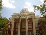
- 1911 Lometa-Eden branch of the Gulf, Colorado and Santa Fe Railway comes through San Saba County. San Saba County brick and sandstone courthouse is erected. Architect Chamberlin & Co.
- 1930 Half of the county farms are Tenant farmingTenant farmerA tenant farmer is one who resides on and farms land owned by a landlord. Tenant farming is an agricultural production system in which landowners contribute their land and often a measure of operating capital and management; while tenant farmers contribute their labor along with at times varying...
. Uncle Billy Gibbons gives the Boy Scouts of AmericaBoy Scouts of AmericaThe Boy Scouts of America is one of the largest youth organizations in the United States, with over 4.5 million youth members in its age-related divisions...
a 99-year lease to campgrounds along Brady CreekBrady Creek (San Saba River)-References:**USGS Hydrologic Unit Map - State of Texas...
on his ranch. - 1938 San Saba River floods causing county-wide devastation. One-third of the town of San Saba is under water.
- 1940 Town of San Saba is incorporated.
- 1953-56 Prolonged drought brings hardship to the county agricultural economy.
- 1960 San Saba County News merges with the San Saba Star.
- 1965 Historical marker honors pioneer doctor Edward D. Doss.
Geography
United States Census Bureau
The United States Census Bureau is the government agency that is responsible for the United States Census. It also gathers other national demographic and economic data...
, the county has a total area of 1138 square miles (2,947.4 km²), of which 1134 square miles (2,937 km²) is land and 4 square miles (10.4 km²) (0.33%) is water.
Major highways
 U.S. Highway 190
 State Highway 16State Highway 16 (Texas)State Highway 16, or SH 16, is a north–south state highway that runs from U.S. Highway 281 24 miles south of Wichita Falls to Zapata on the Texas-Mexico boundary...
 Farm to Market Road 45Farm to Market Road 45Farm to Market Road 45, or FM 45, is a state highway in the U.S. state of Texas that runs from US 190 in Richland Springs north to US 377 about 5 miles south of Brownwood...
Adjacent counties
- Mills CountyMills County, TexasMills County is a county located on the Edwards Plateau in Central Texas. In 2000, its population was 5,151. Mills County is named for John T. Mills, a justice of the Texas Supreme Court...
(north) - Lampasas CountyLampasas County, TexasLampasas County is a county located on the Edwards Plateau in the U.S. state of Texas. In 2000, its population was 17,762. Its seat is Lampasas. The county is named for the Lampasas River....
(east) - Burnet CountyBurnet County, TexasBurnet County is a county located on the Edwards Plateau in the U.S. state of Texas. As of 2000, the population was 34,147. The 2008 Census Bureau Estimate was 44,488. Its county seat is Burnet. Burnet is named for David Gouverneur Burnet, the first president of the Republic of Texas...
(southeast) - Llano CountyLlano County, TexasLlano County is a county located on the Edwards Plateau in the U.S. state of Texas. In 2010, its population was 19, 301. Its county seat is Llano, and the county is named for the Llano River....
(south) - Mason CountyMason County, TexasMason County is a county located on the Edwards Plateau in the U.S. state of Texas. In 2010, its population was 4, 012. Its county seat is Mason...
(southwest) - McCulloch CountyMcCulloch County, TexasMcCulloch County is a county located on the Edwards Plateau in the U.S. state of Texas. The geographical center of Texas lies within the county. In 2000, its population was 8,205. Its county seat is Brady. McCulloch is named for Benjamin McCulloch, a famous Texas Ranger and Confederate...
(west) - Brown CountyBrown County, TexasBrown County is a county in West Central Texas. As of 2000, the population was 37,674. Its county seat is Brownwood. Brown is named for Henry Stevenson Brown, a commander at the Battle of Velasco...
(northwest)
Demographics
As of the censusCensus
A census is the procedure of systematically acquiring and recording information about the members of a given population. It is a regularly occurring and official count of a particular population. The term is used mostly in connection with national population and housing censuses; other common...
of 2010, there were 6,131 people, 2,289 households, and 1,616 families residing in the county. The population density
Population density
Population density is a measurement of population per unit area or unit volume. It is frequently applied to living organisms, and particularly to humans...
was 6 people per square mile (2/km²). There were 2,951 housing units at an average density of 3 per square mile (1/km²). The racial makeup of the county was 84.50% White
Race (United States Census)
Race and ethnicity in the United States Census, as defined by the Federal Office of Management and Budget and the United States Census Bureau, are self-identification data items in which residents choose the race or races with which they most closely identify, and indicate whether or not they are...
, 2.73% Black
Race (United States Census)
Race and ethnicity in the United States Census, as defined by the Federal Office of Management and Budget and the United States Census Bureau, are self-identification data items in which residents choose the race or races with which they most closely identify, and indicate whether or not they are...
or African American
Race (United States Census)
Race and ethnicity in the United States Census, as defined by the Federal Office of Management and Budget and the United States Census Bureau, are self-identification data items in which residents choose the race or races with which they most closely identify, and indicate whether or not they are...
, 1.07% Native American
Race (United States Census)
Race and ethnicity in the United States Census, as defined by the Federal Office of Management and Budget and the United States Census Bureau, are self-identification data items in which residents choose the race or races with which they most closely identify, and indicate whether or not they are...
, 0.11% Asian
Race (United States Census)
Race and ethnicity in the United States Census, as defined by the Federal Office of Management and Budget and the United States Census Bureau, are self-identification data items in which residents choose the race or races with which they most closely identify, and indicate whether or not they are...
, 10.52% from other races
Race (United States Census)
Race and ethnicity in the United States Census, as defined by the Federal Office of Management and Budget and the United States Census Bureau, are self-identification data items in which residents choose the race or races with which they most closely identify, and indicate whether or not they are...
, and 1.07% from two or more races. 21.55% of the population were Hispanic
Race (United States Census)
Race and ethnicity in the United States Census, as defined by the Federal Office of Management and Budget and the United States Census Bureau, are self-identification data items in which residents choose the race or races with which they most closely identify, and indicate whether or not they are...
or Latino
Race (United States Census)
Race and ethnicity in the United States Census, as defined by the Federal Office of Management and Budget and the United States Census Bureau, are self-identification data items in which residents choose the race or races with which they most closely identify, and indicate whether or not they are...
of any race.
There were 2,289 households out of which 29.10% had children under the age of 18 living with them, 58.90% were married couples
Marriage
Marriage is a social union or legal contract between people that creates kinship. It is an institution in which interpersonal relationships, usually intimate and sexual, are acknowledged in a variety of ways, depending on the culture or subculture in which it is found...
living together, 8.40% had a female householder with no husband present, and 29.40% were non-families. 27.50% of all households were made up of individuals and 15.90% had someone living alone who was 65 years of age or older. The average household size was 2.45 and the average family size was 2.97.
In the county, the population was spread out with 27.90% under the age of 18, 8.20% from 18 to 24, 20.80% from 25 to 44, 22.80% from 45 to 64, and 20.30% who were 65 years of age or older. The median age was 39 years. For every 100 females there were 107.40 males. For every 100 females age 18 and over, there were 97.10 males.
The median income for a household in the county was $30,104, and the median income for a family was $35,255. Males had a median income of $25,334 versus $20,111 for females. The per capita income
Per capita income
Per capita income or income per person is a measure of mean income within an economic aggregate, such as a country or city. It is calculated by taking a measure of all sources of income in the aggregate and dividing it by the total population...
for the county was $15,309. About 13.30% of families and 16.60% of the population were below the poverty line, including 24.50% of those under age 18 and 11.60% of those age 65 or over.
Local Attractions
San Saba County is home to the only suspension bridge open to traffic in the state of Texas, The Regency Bridge spanning the Colorado RiverColorado River (Texas)
The Colorado River is a river that runs through the U.S. state of Texas; it should not be confused with the much longer Colorado River which flows from Colorado into the Gulf of California....
, located off FM 500 in the northern part of the county, was built in 1939.
The Beveridge Bridge, built in 1896 spanning the San Saba River
San Saba River
The San Saba River is a river in the U.S. state of Texas. It is an undeveloped and scenic waterway located on the northern boundary of the Edwards Plateau.-Course:...
, was the only other suspension bridge in Texas open to traffic until 2004 when it was replaced by a concrete bridge. The Beveridge Bridge has been restored and is open as a pedestrian bridge. The bridge is located on the northwest edge of the city of San Saba, on China Creek Road, just north of the Wedding Oak.
Towns
- San SabaSan Saba, TexasSan Saba is a town located in Central Texas. It was settled in 1854 and named for its location on the San Saba River. The population was at the 2000 census. It is the county seat of San Saba County...
- Richland SpringsRichland Springs, TexasRichland Springs is a town in San Saba County in Western Central Texas. The population was 350 at the 2000 census.-Geography:Richland Springs is located at ....
- CherokeeCherokee, TexasCherokee is an unincorporated community in San Saba County in Western Central Texas. According to the Handbook of Texas, the community had an estimated population of 175 in 2000.-Geography:Cherokee is located at...
Notable people
- Abraham Lincoln Galloway (March 3, 1901—August 17, 1961) was a rancher in San Saba County. An historical marker at the courthouse in San Saba describes him as: "One of the greatest San Saba cowboyCowboyA cowboy is an animal herder who tends cattle on ranches in North America, traditionally on horseback, and often performs a multitude of other ranch-related tasks. The historic American cowboy of the late 19th century arose from the vaquero traditions of northern Mexico and became a figure of...
s ever to grace the back of a horseHorseThe horse is one of two extant subspecies of Equus ferus, or the wild horse. It is a single-hooved mammal belonging to the taxonomic family Equidae. The horse has evolved over the past 45 to 55 million years from a small multi-toed creature into the large, single-toed animal of today...
. He enjoyed deep and lasting friendships with many. Abe was truly a good man with a heart as big as the cowboy's loop he was known for throwing. His integrity and his word were accepted by all who knew him, a handshake was his bond." Galloway, a son of Mr. and Mrs. Henry C. Galloway, is interred at Hillcrest Cemetery.
- Another San Saba County historical marker honors the Texas state District Judge Jack B. Miller (October 21, 1921—February 15, 1991).
See also
- AdelsvereinAdelsvereinSociety for the Protection of German Immigrants in Texas, better known as Adelsverein , organized on April 20, 1842, was a colonial attempt to establish a new Germany within the borders of Texas.-History:...
- German TexanGerman TexanGerman Texan is an ethnic category that includes residents of the state of Texas with German ancestry who identify with the term. This identification may include cultural agreements—German language, German cuisine, feasts, music, hard work, frugality, and close family ties. From their first...
- National Register of Historic Places listings in San Saba County, Texas