
Erath County, Texas
Encyclopedia
Erath County is a county located on the Edwards Plateau
in the U.S. state
of Texas
. In 2000, its population was 33,001. It is named for George Bernard Erath, an early surveyor and a soldier at the Battle of San Jacinto
. The seat
of the county is Stephenville
.
Erath County is also home to two of North America's largest renewable natural gas
plants. The largest being operated at Huckabay Ridge, near Stephenville. The second largest being located outside of Dublin at Rio Leche Estates. On November 4, 2008, Erath County voters elected to allow the sale of beer and wine in the county for off-premise consumption.
, the county has a total area of 1090 square miles (2,823.1 km²), of which 1086 square miles (2,812.7 km²) is land and 3 square miles (7.8 km²) (0.32%) is water.
of 2000, there were 33,001 people, 12,568 households, and 8,106 families residing in the county. The population density
was 30 people per square mile (12/km²). There were 14,422 housing units at an average density of 13 per square mile (5/km²). The racial makeup of the county was 89.72% White
, 0.82% Black
or African American
, 0.66% Native American
, 0.36% Asian
, 0.03% Pacific Islander
, 6.78% from other races
, and 1.63% from two or more races. 15.03% of the population were Hispanic
or Latino
of any race.
There were 12,568 households out of which 31.00% had children under the age of 18 living with them, 53.70% were married couples
living together, 7.20% had a female householder with no husband present, and 35.50% were non-families. 27.70% of all households were made up of individuals and 10.10% had someone living alone who was 65 years of age or older. The average household size was 2.48 and the average family size was 3.08.
In the county, the population was spread out with 24.60% under the age of 18, 17.00% from 18 to 24, 25.90% from 25 to 44, 19.10% from 45 to 64, and 13.40% who were 65 years of age or older. The median age was 31 years. For every 100 females there were 97.80 males. For every 100 females age 18 and over, there were 95.90 males.
The median income for a household in the county was $30,708, and the median income for a family was $39,491. Males had a median income of $27,972 versus $20,765 for females. The per capita income
for the county was $16,655. About 10.30% of families and 16.00% of the population were below the poverty line, including 15.70% of those under age 18 and 7.80% of those age 65 or over.
tribe Anadarko
villages were scattered along Trinity
and Brazos
Rivers. French
explorer Jean-Baptiste Bénard de la Harpe
developed camaraderie among the Anadarko in 1719 when he established Fort Saint Louis de los Cadodaquious. The Anadarko became entangled with the French battles with the Spanish
and later the Anglos and suffered the consequences, including diseases for which they had no immunity. By 1860, these tribes moved to Oklahoma
. Erath County falls into Comancheria
and found itself raided by Comanches until their removal to Oklahoma after 1875.
and Coryell
counties in 1856 and named for George Bernard Erath, one of the original surveyors of the area. In 1856 John M. Stephen offered to donate land for a townsite which was named Stephenville
after him and became the county seat.
A. H. Dobkins founded the community of Dublin
in 1854. Other early settlers in Dublin were Will and Tom Holland. Dublin later became famous as the early boyhood home of PGA
, U.S. Open
and Masters golf champion Ben Hogan
.
In 1855, thirty pioneers settled in the county, led by surveyors George Erath and Neil McLennan
.
Included in the group were brothers William F. and John M. Stephen, and a black family whose name and destiny seems to have been lost to history.
Vienna, Austria immigrant Erath (1813–1891) was a Texas Ranger and member of Billingsley’s Company C, 1st Regiment of Texas Volunteers, under the command of Col. Charles Burleson at the Battle of San Jacinto
, and a member of the Confederate Home Guard
. As a Freemason, he was a charter member and secretary of Bosque Lodge #92, 1852 through 1855.
Cotton became the major crop 1875-1915, with the largest crop being in 1906. The industry was helped in 1879 when the Texas Central Railroad reached Dublin, and in 1889 when the Fort Worth and Rio Grande was completed through Stephenville. This opened eastern markets for the county's cotton crops. By 1910, soil erosion and the boll weevil
caused diversity planning that led to dairy farms, fruit orchards, nurseries, peanuts, feed crops, and poultry.
The community of Thurber
was created by the Johnson Coal Company. During the period from 1888 to 1921 the Texas Pacific Coal Company mined coal near Thurber, making it a leading coal producer in the state. Fifty-two percent of the miners were of Italian
ancestry, creating the “Italian Hill” community just outside of Thurber. The United Mine Workers
in 1903 send Joe Fenoglio to organize the Italian workers, thus beginning the Thurber Coal Miners Strike. In the 1970s, the area began bituminous coal production for fuel in the cement industry.
Tarleton State University
was founded in 1893 as Stephenville College but was renamed in 1899 after local rancher John Tarleton rescued the institution from financial difficulties.
and D. E. Laub designed the present three-story showcase Victorian structure. In addition to Erath, Gordon designed the Arizona
State Capitol, and courthouses in Aransas
, Bexar
, Brazoria
, Comal
, Ellis
, Fayette
, Gonzales
, Harrison
, Hopkins
, Lee, McLennan
, Victoria
and Wise
counties. The building was completed in 1893, with limestone from the Leon River
and red sandstone from Pecos County
. The building’s centralized 95-foot tower has a bell tower and creates a chandeliered atrium from the first floor to the third. The interior is east Texas pine, with cast and wrought-iron stairways, and tessellated imported marble floors. It was renovated in 1988.
/Fort Worth
and Waco
/Temple
/Killeen
metropolitan areas.
Five radio stations have their main studios and offices in Erath County:
KEQX
89.7, KTRL-FM
90.5, KSTV-FM
93.1, KURT-LP FM 100.7 and KSTV (AM)
1510. Two of these (KTRL-FM
and KURT-LP FM) are operated by Tarleton State University
.
Edwards Plateau
The Edwards Plateau is a region of west-central Texas which is bounded by the Balcones Fault to the south and east, the Llano Uplift and the Llano Estacado to the north, and the Pecos River and Chihuahuan Desert to the west. San Angelo, Austin, San Antonio and Del Rio roughly outline the area...
in the U.S. state
U.S. state
A U.S. state is any one of the 50 federated states of the United States of America that share sovereignty with the federal government. Because of this shared sovereignty, an American is a citizen both of the federal entity and of his or her state of domicile. Four states use the official title of...
of Texas
Texas
Texas is the second largest U.S. state by both area and population, and the largest state by area in the contiguous United States.The name, based on the Caddo word "Tejas" meaning "friends" or "allies", was applied by the Spanish to the Caddo themselves and to the region of their settlement in...
. In 2000, its population was 33,001. It is named for George Bernard Erath, an early surveyor and a soldier at the Battle of San Jacinto
Battle of San Jacinto
The Battle of San Jacinto, fought on April 21, 1836, in present-day Harris County, Texas, was the decisive battle of the Texas Revolution. Led by General Sam Houston, the Texian Army engaged and defeated General Antonio López de Santa Anna's Mexican forces in a fight that lasted just eighteen...
. The seat
County seat
A county seat is an administrative center, or seat of government, for a county or civil parish. The term is primarily used in the United States....
of the county is Stephenville
Stephenville, Texas
Stephenville is a city in and the county seat of Erath County, Texas, United States. The population was 14,921 at the 2000 census. Founded in 1856, it is home to Tarleton State University. Stephenville is among several communities that calls itself the "Cowboy Capital of the...
.
Erath County is also home to two of North America's largest renewable natural gas
Renewable natural gas
Renewable natural gas, also known as sustainable natural gas, is a biogas which has been upgraded to a quality similar to fossil natural gas. A biogas is a gas methane obtained from biomass. By upgrading the quality to that of natural gas, it becomes possible to distribute the gas to customers via...
plants. The largest being operated at Huckabay Ridge, near Stephenville. The second largest being located outside of Dublin at Rio Leche Estates. On November 4, 2008, Erath County voters elected to allow the sale of beer and wine in the county for off-premise consumption.
Geography
According to the U.S. Census BureauUnited States Census Bureau
The United States Census Bureau is the government agency that is responsible for the United States Census. It also gathers other national demographic and economic data...
, the county has a total area of 1090 square miles (2,823.1 km²), of which 1086 square miles (2,812.7 km²) is land and 3 square miles (7.8 km²) (0.32%) is water.
Major highways
 Interstate 20
 U.S. Highway 67
 U.S. Highway 281
 U.S. Highway 377
 State Highway 6State Highway 6 (Texas)State Highway 6 runs from the Red River, the Texas–Oklahoma boundary, to northwest of Galveston. In the Houston area, it runs north to FM 1960, then northwest along US Highway 290 to Hempstead, and south to Westheimer Road and Addicks, and is known as Addicks Satsuma Road. In the...
 State Highway 108State Highway 108 (Texas)State Highway 108 or SH 108 is a state highway that runs from Strawn to Stephenville. The route was proposed in 1926 as a renumbering of SH 10A.-Route description:...
Adjacent counties
- Palo Pinto CountyPalo Pinto County, TexasAs of the census of 2000, there were 27,026 people, 10,594 households, and 7,447 families residing in the county. The population density was 28 people per square mile . There were 14,102 housing units at an average density of 15 per square mile...
(north) - Hood County (northeast)
- Somervell CountySomervell County, TexasThere were 2,438 households out of which 37.40% had children under the age of 18 living with them, 61.70% were married couples living together, 9.60% had a female householder with no husband present, and 24.50% were non-families. 21.30% of all households were made up of individuals and 9.20% had...
(east) - Bosque CountyBosque County, TexasBosque County is a county located on the Edwards Plateau in the U.S. state of Texas. As of 2000, the population is 17,204. Its county seat is Meridian. Clifton, however, is the largest city and the cultural/financial center of the county. Bosque is named for the Bosque River, which runs through...
(southeast) - Hamilton County (south)
- Comanche CountyComanche County, TexasComanche County is a county located on the Edwards Plateau in Central Texas. In 2000, its population was 14,026. Comanche was founded in 1856. Comanche is named for the Comanche Native American tribe...
(southwest) - Eastland CountyEastland County, Texas*Carbon*Cisco*Desdemona, a ghost town*Eastland*Gorman*Mangum*Olden*Ranger*Rising Star*Romney-See also:*National Register of Historic Places listings in Eastland County, Texas*Santa Claus Bank Robbery-External links:** at the University of Texas*...
(west)
Demographics
As of the censusCensus
A census is the procedure of systematically acquiring and recording information about the members of a given population. It is a regularly occurring and official count of a particular population. The term is used mostly in connection with national population and housing censuses; other common...
of 2000, there were 33,001 people, 12,568 households, and 8,106 families residing in the county. The population density
Population density
Population density is a measurement of population per unit area or unit volume. It is frequently applied to living organisms, and particularly to humans...
was 30 people per square mile (12/km²). There were 14,422 housing units at an average density of 13 per square mile (5/km²). The racial makeup of the county was 89.72% White
Race (United States Census)
Race and ethnicity in the United States Census, as defined by the Federal Office of Management and Budget and the United States Census Bureau, are self-identification data items in which residents choose the race or races with which they most closely identify, and indicate whether or not they are...
, 0.82% Black
Race (United States Census)
Race and ethnicity in the United States Census, as defined by the Federal Office of Management and Budget and the United States Census Bureau, are self-identification data items in which residents choose the race or races with which they most closely identify, and indicate whether or not they are...
or African American
Race (United States Census)
Race and ethnicity in the United States Census, as defined by the Federal Office of Management and Budget and the United States Census Bureau, are self-identification data items in which residents choose the race or races with which they most closely identify, and indicate whether or not they are...
, 0.66% Native American
Race (United States Census)
Race and ethnicity in the United States Census, as defined by the Federal Office of Management and Budget and the United States Census Bureau, are self-identification data items in which residents choose the race or races with which they most closely identify, and indicate whether or not they are...
, 0.36% Asian
Race (United States Census)
Race and ethnicity in the United States Census, as defined by the Federal Office of Management and Budget and the United States Census Bureau, are self-identification data items in which residents choose the race or races with which they most closely identify, and indicate whether or not they are...
, 0.03% Pacific Islander
Race (United States Census)
Race and ethnicity in the United States Census, as defined by the Federal Office of Management and Budget and the United States Census Bureau, are self-identification data items in which residents choose the race or races with which they most closely identify, and indicate whether or not they are...
, 6.78% from other races
Race (United States Census)
Race and ethnicity in the United States Census, as defined by the Federal Office of Management and Budget and the United States Census Bureau, are self-identification data items in which residents choose the race or races with which they most closely identify, and indicate whether or not they are...
, and 1.63% from two or more races. 15.03% of the population were Hispanic
Race (United States Census)
Race and ethnicity in the United States Census, as defined by the Federal Office of Management and Budget and the United States Census Bureau, are self-identification data items in which residents choose the race or races with which they most closely identify, and indicate whether or not they are...
or Latino
Race (United States Census)
Race and ethnicity in the United States Census, as defined by the Federal Office of Management and Budget and the United States Census Bureau, are self-identification data items in which residents choose the race or races with which they most closely identify, and indicate whether or not they are...
of any race.
There were 12,568 households out of which 31.00% had children under the age of 18 living with them, 53.70% were married couples
Marriage
Marriage is a social union or legal contract between people that creates kinship. It is an institution in which interpersonal relationships, usually intimate and sexual, are acknowledged in a variety of ways, depending on the culture or subculture in which it is found...
living together, 7.20% had a female householder with no husband present, and 35.50% were non-families. 27.70% of all households were made up of individuals and 10.10% had someone living alone who was 65 years of age or older. The average household size was 2.48 and the average family size was 3.08.
In the county, the population was spread out with 24.60% under the age of 18, 17.00% from 18 to 24, 25.90% from 25 to 44, 19.10% from 45 to 64, and 13.40% who were 65 years of age or older. The median age was 31 years. For every 100 females there were 97.80 males. For every 100 females age 18 and over, there were 95.90 males.
The median income for a household in the county was $30,708, and the median income for a family was $39,491. Males had a median income of $27,972 versus $20,765 for females. The per capita income
Per capita income
Per capita income or income per person is a measure of mean income within an economic aggregate, such as a country or city. It is calculated by taking a measure of all sources of income in the aggregate and dividing it by the total population...
for the county was $16,655. About 10.30% of families and 16.00% of the population were below the poverty line, including 15.70% of those under age 18 and 7.80% of those age 65 or over.
Native Americans
CaddoCaddo
The Caddo Nation is a confederacy of several Southeastern Native American tribes, who traditionally inhabited much of what is now East Texas, northern Louisiana and portions of southern Arkansas and Oklahoma. Today the Caddo Nation of Oklahoma is a cohesive tribe with its capital at Binger, Oklahoma...
tribe Anadarko
Nadaco
The Nadaco, also commonly known as the Anadarko, are a Native American tribe from eastern Texas. Their name, Nadá-kuh, means "bumblebee place."-History:The Nadaco were part of the Hasinai branch of the Caddo Confederacy....
villages were scattered along Trinity
Trinity River (Texas)
The Trinity River is a long river that flows entirely within the U.S. state of Texas. It rises in extreme north Texas, a few miles south of the Red River. The headwaters are separated by the high bluffs on the south side of the Red River....
and Brazos
Brazos River
The Brazos River, called the Rio de los Brazos de Dios by early Spanish explorers , is the longest river in Texas and the 11th longest river in the United States at from its source at the head of Blackwater Draw, Curry County, New Mexico to its mouth at the Gulf of Mexico with a drainage...
Rivers. French
French people
The French are a nation that share a common French culture and speak the French language as a mother tongue. Historically, the French population are descended from peoples of Celtic, Latin and Germanic origin, and are today a mixture of several ethnic groups...
explorer Jean-Baptiste Bénard de la Harpe
Bernard de la Harpe
Bernard de la Harpe or Jean-Baptiste Bénard de la Harpe was a French explorer who is credited with the discovery of Little Rock, Arkansas. In 1722, la Harpe found two distinct rock formations on the Arkansas River, the smaller one the South bank he named La Petite Roche and the larger on the North...
developed camaraderie among the Anadarko in 1719 when he established Fort Saint Louis de los Cadodaquious. The Anadarko became entangled with the French battles with the Spanish
Spanish people
The Spanish are citizens of the Kingdom of Spain. Within Spain, there are also a number of vigorous nationalisms and regionalisms, reflecting the country's complex history....
and later the Anglos and suffered the consequences, including diseases for which they had no immunity. By 1860, these tribes moved to Oklahoma
Oklahoma
Oklahoma is a state located in the South Central region of the United States of America. With an estimated 3,751,351 residents as of the 2010 census and a land area of 68,667 square miles , Oklahoma is the 28th most populous and 20th-largest state...
. Erath County falls into Comancheria
Comancheria
The Comancheria is the name commonly given to the region of New Mexico, west Texas and nearby areas occupied by the Comanche before the 1860s.-Geography:...
and found itself raided by Comanches until their removal to Oklahoma after 1875.
County established and growth
Erath County was formed from BosqueBosque County, Texas
Bosque County is a county located on the Edwards Plateau in the U.S. state of Texas. As of 2000, the population is 17,204. Its county seat is Meridian. Clifton, however, is the largest city and the cultural/financial center of the county. Bosque is named for the Bosque River, which runs through...
and Coryell
Coryell County, Texas
Coryell County is a county located on the Edwards Plateau in the U.S. state of Texas. In 2000, its population was 74,978. The county seat is Gatesville. Coryell County forms part of the Killeen–Temple–Fort Hood Metropolitan Statistical Area...
counties in 1856 and named for George Bernard Erath, one of the original surveyors of the area. In 1856 John M. Stephen offered to donate land for a townsite which was named Stephenville
Stephenville, Texas
Stephenville is a city in and the county seat of Erath County, Texas, United States. The population was 14,921 at the 2000 census. Founded in 1856, it is home to Tarleton State University. Stephenville is among several communities that calls itself the "Cowboy Capital of the...
after him and became the county seat.
A. H. Dobkins founded the community of Dublin
Dublin, Texas
Dublin is a city located in southwestern Erath County in Central Texas. The population was 3,754 at the time of the 2000 census.The town is the home of the world's oldest Dr Pepper bottling plant...
in 1854. Other early settlers in Dublin were Will and Tom Holland. Dublin later became famous as the early boyhood home of PGA
PGA Championship
The PGA Championship is an annual golf tournament conducted by the PGA of America as part of the PGA Tour. It is one of the four major championships in men's professional golf, and is the golf season's final major, usually played in mid-August, customarily four weeks after The Open Championship...
, U.S. Open
U.S. Open (golf)
The United States Open Championship, commonly known as the U.S. Open, is the annual open golf tournament of the United States. It is the second of the four major championships in golf, and is on the official schedule of both the PGA Tour and the European Tour...
and Masters golf champion Ben Hogan
Ben Hogan
William Ben Hogan was an American golfer, generally considered one of the greatest players in the history of the game...
.
In 1855, thirty pioneers settled in the county, led by surveyors George Erath and Neil McLennan
Neil McLennan
Neil McLennan, an early Scottish-American settler of Texas, was born on the Isle of Skye in Scotland on September 2, 1777, 1778 or 1787, and died in Texas in 1867. McLennan County, Texas was named for him....
.
Included in the group were brothers William F. and John M. Stephen, and a black family whose name and destiny seems to have been lost to history.
Vienna, Austria immigrant Erath (1813–1891) was a Texas Ranger and member of Billingsley’s Company C, 1st Regiment of Texas Volunteers, under the command of Col. Charles Burleson at the Battle of San Jacinto
Battle of San Jacinto
The Battle of San Jacinto, fought on April 21, 1836, in present-day Harris County, Texas, was the decisive battle of the Texas Revolution. Led by General Sam Houston, the Texian Army engaged and defeated General Antonio López de Santa Anna's Mexican forces in a fight that lasted just eighteen...
, and a member of the Confederate Home Guard
Confederate Home Guard
The Confederate Home Guard was a somewhat loosely organized militia that was under the direction and authority of the Confederate States of America, working in coordination with the Confederate Army, and was tasked with both the defense of the Confederate home front during the American Civil War,...
. As a Freemason, he was a charter member and secretary of Bosque Lodge #92, 1852 through 1855.
Cotton became the major crop 1875-1915, with the largest crop being in 1906. The industry was helped in 1879 when the Texas Central Railroad reached Dublin, and in 1889 when the Fort Worth and Rio Grande was completed through Stephenville. This opened eastern markets for the county's cotton crops. By 1910, soil erosion and the boll weevil
Boll weevil
The boll weevil is a beetle measuring an average length of six millimeters, which feeds on cotton buds and flowers. Thought to be native to Central America, it migrated into the United States from Mexico in the late 19th century and had infested all U.S. cotton-growing areas by the 1920s,...
caused diversity planning that led to dairy farms, fruit orchards, nurseries, peanuts, feed crops, and poultry.
The community of Thurber
Thurber, Texas
Thurber is a coal-mining ghost town in Erath County, Texas, United States, located 75 miles west of Fort Worth. It currently has an overall population of about twenty five.-History:...
was created by the Johnson Coal Company. During the period from 1888 to 1921 the Texas Pacific Coal Company mined coal near Thurber, making it a leading coal producer in the state. Fifty-two percent of the miners were of Italian
Italian people
The Italian people are an ethnic group that share a common Italian culture, ancestry and speak the Italian language as a mother tongue. Within Italy, Italians are defined by citizenship, regardless of ancestry or country of residence , and are distinguished from people...
ancestry, creating the “Italian Hill” community just outside of Thurber. The United Mine Workers
United Mine Workers
The United Mine Workers of America is a North American labor union best known for representing coal miners and coal technicians. Today, the Union also represents health care workers, truck drivers, manufacturing workers and public employees in the United States and Canada...
in 1903 send Joe Fenoglio to organize the Italian workers, thus beginning the Thurber Coal Miners Strike. In the 1970s, the area began bituminous coal production for fuel in the cement industry.
Tarleton State University
Tarleton State University
Tarleton State University is a public, coeducational, state university located in Stephenville, Texas. It is the largest non-land-grant university primarily devoted to agriculture in the United States....
was founded in 1893 as Stephenville College but was renamed in 1899 after local rancher John Tarleton rescued the institution from financial difficulties.
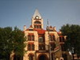
Courthouse
Erath’s original 1866 wooden courthouse burned to the ground, destroying county documents along with it. A second stone courthouse was built in 1877 but eventually razed. The cornerstone for the current courthouse was laid in 1891. Architects James Riely GordonJames Riely Gordon
James Riely Gordon was an architect of courthouses throughout the United States and the state of Texas in particular. Gordon's specialty was constructing public buildings mainly in the Romanesque Revival style. His most successful plan was that of a Greek cross with a square central stairwell and...
and D. E. Laub designed the present three-story showcase Victorian structure. In addition to Erath, Gordon designed the Arizona
Arizona
Arizona ; is a state located in the southwestern region of the United States. It is also part of the western United States and the mountain west. The capital and largest city is Phoenix...
State Capitol, and courthouses in Aransas
Aransas County, Texas
Aransas County is a county located in the U.S. state of Texas. It is part of the Corpus Christi Metropolitan Statistical Area. As of 2000, the population was 22,499. Its county seat is Rockport. Aransas County was formed in 1871 from Refugio County.-Geography:According to the U.S...
, Bexar
Bexar County, Texas
As of the census of 2000, there were 1,392,931 people, 488,942 households, and 345,681 families residing in the county. The population density was 1,117 people per square mile . There were 521,359 housing units at an average density of 418 per square mile...
, Brazoria
Brazoria County, Texas
Brazoria County[p] is a county in the U.S. state of Texas, located on the Gulf Coast within the Houston–Sugar Land–Baytown metropolitan area. Regionally, parts of the county are within the extreme southern-most fringe of the regions locally known as Southeast Texas. Brazoria County is among a...
, Comal
Comal County, Texas
Comal County is a county located on the Edwards Plateau in the U.S. state of Texas. In 2010, its population was 108,472. Its seat is New Braunfels.Comal County is part of the San Antonio Metropolitan Statistical Area.-History Timeline:...
, Ellis
Ellis County, Texas
As of the census of 2000, there were 111,360 people, 37,020 households, and 29,653 families residing in the county. The population density was 118 people per square mile . There were 39,071 housing units at an average density of 42 per square mile...
, Fayette
Fayette County, Texas
Fayette County is a county located in the U.S. state of Texas. As of 2000, the population was 21,804. Its county seat is La Grange. Fayette is named for the Marquis de la Fayette, a French nobleman who became an American Revolutionary War hero...
, Gonzales
Gonzales County, Texas
Gonzales County is a county located in the U.S. state of Texas. In 2000, its population was 18,628. It is named for its seat, the city of Gonzales.-History Timeline:* Paleo-Indians Hunter-gatherers, and later Coahuiltecan, Tonkawa, Karankawa...
, Harrison
Harrison County, Texas
Harrison County is a county of the U.S. state of Texas. In 2000, its population was 62,110. It is named for Jonas Harrison, a lawyer and Texas revolutionary. It is located in the Ark-La-Tex region...
, Hopkins
Hopkins County, Texas
*Brashear*Dike*Como*Cumby*Gafford*Pickton*Saltillo*Sulphur Bluff*Sulphur Springs*Tira-See also:*National Register of Historic Places listings in Hopkins County, Texas-External links:*...
, Lee, McLennan
McLennan County, Texas
McLennan County is a county located on the Edwards Plateau in Central Texas. In 2000, its population was 213,517; in 2008 the U.S. Census Bureau estimated its population to be 230,213. Its seat is Waco. The county is named for Neil McLennan, an early settler....
, Victoria
Victoria County, Texas
Victoria County is a county located in the U.S. state of Texas. In 2000, its population was 84,088. Its county seat is Victoria. It is included in the Victoria, Texas Metropolitan Statistical Area.-Geography:According to the U.S...
and Wise
Wise County, Texas
As of the census of 2000, there were 48,793 people, 17,178 households, and 13,467 families residing in the county. The population density was 54 people per square mile . There were 19,242 housing units at an average density of 21 per square mile...
counties. The building was completed in 1893, with limestone from the Leon River
Leon River
The Leon River is a river in the U.S. state of Texas. It has three primary forks; the North, Middle, and South Leon rivers which meet near Eastland and then run for around 185 miles until it meets up with the Lampasas River and the Salado Creek to form the Little River near Belton....
and red sandstone from Pecos County
Pecos County, Texas
Pecos County is a county located in Texas which is named for the Pecos River. It is one of the nine counties that comprise the Trans-Pecos region of West Texas. In 2000, its population was 16,809. The county seat is Fort Stockton....
. The building’s centralized 95-foot tower has a bell tower and creates a chandeliered atrium from the first floor to the third. The interior is east Texas pine, with cast and wrought-iron stairways, and tessellated imported marble floors. It was renovated in 1988.
Local media
Two newspapers have offices located in Erath County: The Stephenville Empire-Tribune and The Dublin Citizen. Local television stations that provide coverage for Erath County and surrounding areas come from the DallasDallas, Texas
Dallas is the third-largest city in Texas and the ninth-largest in the United States. The Dallas-Fort Worth Metroplex is the largest metropolitan area in the South and fourth-largest metropolitan area in the United States...
/Fort Worth
Fort Worth, Texas
Fort Worth is the 16th-largest city in the United States of America and the fifth-largest city in the state of Texas. Located in North Central Texas, just southeast of the Texas Panhandle, the city is a cultural gateway into the American West and covers nearly in Tarrant, Parker, Denton, and...
and Waco
Waco, Texas
Waco is a city in and the county seat of McLennan County, Texas. Situated along the Brazos River and on the I-35 corridor, halfway between Dallas and Austin, it is the economic, cultural, and academic center of the 'Heart of Texas' region....
/Temple
Temple, Texas
Temple is a city in Bell County, Texas, United States. Located near the county seat of Belton, Temple lies in the region referred to as Central Texas. Located off Interstate 35, Temple is 65 miles north of Austin and 34 miles south of Waco. In the 2010 Census, Temple's population was 66,102, an...
/Killeen
Killeen, Texas
Killeen is a city in Bell County, Texas, The United States. The population was 86,911 at the 2000 census. As of 2009, Killeen had 119,510 people. In 2010 Killeen's population shot to 127,921...
metropolitan areas.
Five radio stations have their main studios and offices in Erath County:
KEQX
KEQX
KEQX is a noncommercial radio station licensed to Stephenville, Texas, USA broadcasting a classic country music format. The station is currently owned by CSSI Non-Profit Educational Broadcasting Corporation. The station is one of the seven stations in the "QXFM" GROUP of stations. KMQX KYQX KSWQX...
89.7, KTRL-FM
KTRL-FM
KTRL–FM 90.5 is a noncommercial public radio station licensed to Tarleton State University in Stephenville, Texas. KTRL broadcasts to a 10–county area of the Cross Timbers just southwest of Fort Worth, Texas, covering a population of about 200,000 people...
90.5, KSTV-FM
KSTV-FM
KSTV-FM is a radio station broadcasting a country music music format. Licensed to Dublin, Texas, USA, the station serves the Stephenville and Cross Timbers area. The station is currently owned by Ccr-Stephenville Iii, LLC and features programing from Citadel Broadcasting.-External links:...
93.1, KURT-LP FM 100.7 and KSTV (AM)
KSTV (AM)
KSTV is a radio station broadcasting a Spanish Variety music format. Licensed to Stephenville, Texas, USA, the station serves the Brownwood area. The station is currently owned by Ccr-Stephenville Iii, LLC....
1510. Two of these (KTRL-FM
KTRL-FM
KTRL–FM 90.5 is a noncommercial public radio station licensed to Tarleton State University in Stephenville, Texas. KTRL broadcasts to a 10–county area of the Cross Timbers just southwest of Fort Worth, Texas, covering a population of about 200,000 people...
and KURT-LP FM) are operated by Tarleton State University
Tarleton State University
Tarleton State University is a public, coeducational, state university located in Stephenville, Texas. It is the largest non-land-grant university primarily devoted to agriculture in the United States....
.
Cities & towns
- AlexanderAlexander, TexasAlexander is an unincorporated community in Erath County, Texas, United States located in the Southern part of the county along Texas State Highway 6 and Fm-914. The town was originally called: "Harper's Mill" when the Post Office was approved for operation around the 1870s...
(unincorporated) - Bluff DaleBluff Dale, TexasBluff Dale is an unincorporated community in Erath County, Texas, United States.The Bluff Dale Independent School District serves area students.- History :BLUFF DALE, Texas is on U.S. Highway 377 and the North Paluxy River in northeastern Erath County...
(unincorporated) - Chalk MountainChalk Mountain, TexasChalk Mountain is a small unincorporated community in Erath County, Texas, United States. It lies along U.S. Route 67 near the Somervell County line, about 25 miles southwest of Glen Rose.-Bengal Kitten:...
(unincorporated) - ClairetteClairette, TexasClairette is an unincorporated community in Erath County, Texas, United States located in the Southern part of the county along Texas State Highway 6 and the Bosque River 6 miles Northwest of Hico, 15 miles South of Stephenville, and 16 miles East of Dublin. The town was founded during the 1880s...
(unincorporated) - DublinDublin, TexasDublin is a city located in southwestern Erath County in Central Texas. The population was 3,754 at the time of the 2000 census.The town is the home of the world's oldest Dr Pepper bottling plant...
- Duffau (unincorporated)
- Edna HillEdna Hill, TexasEdna Hill is an unincorporated community in Erath County, Texas, United States located in the extreme southwestern corner of the county along Fm-1702 around nine miles south of the City of Dublin in Central Texas. The first settlers of the area arrived around the 1850s...
(unincorporated) - Hannibal (unincorporated)
- HarbinHarbin, TexasHarbin is an unincorporated community in Erath County, Texas, United States located in the Southwestern part of the county at the intersections of Fm-847 and the Fort Worth and Western Railroad 4 miles east-northeast of the City of Dublin. The community was settled during the 1860s and was named...
(unincorporated) - HuckabayHuckabay, TexasHuckabay is an unincorporated community located on State Highway 108, ten miles north of Stephenville in Erath County, Texas, United States. It had a population of approximately 150 in 1990.The Huckabay Independent School District serves area students....
(unincorporated) - Johnsville (now known as Three Way)
- LinglevilleLingleville, TexasLingleville is an unincorporated community in Erath County, Texas, United States.The Lingleville Independent School District serves area students.-External links:...
(unincorporated) - LoneOak (unincorporated)
- Morgan MillMorgan Mill, TexasMorgan Mill is an unincorporated community on U.S. Route 281 in northeastern Erath County, Texas, United States. It had a population of approximately 206 in 1990.Now home of 4 time World Champion Bull Rider Tuff Hedeman...
(unincorporated) - Mount Airy (unincorporated)
- OakDaleOakDale, TexasOakDale is an unincorporated community in north central Erath County, Texas, United States. OakDale is located along Texas State Highway 108, between the intersections of Fm-3205 and County Road 456. OakDale formerly had two churches, one of which relocated to nearby Stephenville and is still known...
(unincorporated) - PurvesPurves, TexasPurves is an unincorporated community in Erath County, Texas, United States. Purves is located in the southwestern part of the county, along Fm-219 South, around seven miles southeast of the City of Dublin. The community was named for two local men named Purves who started the Post Office and a...
(unincorporated) - SeldenSelden, TexasSelden is an unincorporated community in south central Erath County, Texas, United States. Selden is located along Fm-913 between US Highway 281 and US Highway 67 around south-southeast of Stephenville. The community was named after a man who owned a ranch nearby during the 1850s. A post office...
(unincorporated) - StephenvilleStephenville, TexasStephenville is a city in and the county seat of Erath County, Texas, United States. The population was 14,921 at the 2000 census. Founded in 1856, it is home to Tarleton State University. Stephenville is among several communities that calls itself the "Cowboy Capital of the...
- Three Way (unincorporated)
- ThurberThurber, TexasThurber is a coal-mining ghost town in Erath County, Texas, United States, located 75 miles west of Fort Worth. It currently has an overall population of about twenty five.-History:...
(unincorporated)
See also
- National Register of Historic Places listings in Erath County, Texas
- Three Way Independent School DistrictThree Way Independent School DistrictThree Way Independent School District is a public school district in Erath County, Texas. A small portion of the district extends into Somervell County....
External links
- Erath County
- Erath County in Handbook of Texas Online at the University of TexasUniversity of Texas at AustinThe University of Texas at Austin is a state research university located in Austin, Texas, USA, and is the flagship institution of the The University of Texas System. Founded in 1883, its campus is located approximately from the Texas State Capitol in Austin...
- Entry for George B. Erath from the Biographical Encyclopedia of Texas published 1880, hosted by the Portal to Texas History.