

Tameside
Encyclopedia
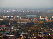
The Metropolitan Borough of Tameside is a metropolitan borough
of Greater Manchester
in North West England
. It is named after the River Tame
which flows through the borough and spans the towns of Ashton-under-Lyne
, Audenshaw
, Denton
, Droylsden
, Dukinfield
, Hyde
, Mossley
and Stalybridge
. Its western border is approximately 4 miles (6.4 km) east of Manchester city centre
. It borders Derbyshire
to the east, the Metropolitan Borough of Oldham
to the north, the Metropolitan Borough of Stockport
to the south, and the City of Manchester
to the west. Tameside has a population of 214,400.
The history of the area extends back to the Stone Age
. There are over 300 listed buildings in Tameside and three Scheduled Ancient Monument
s, which includes a castle
of national importance. The settlements in Tameside were small townships centred around agriculture until the advent of the Industrial Revolution
. The towns of the borough grew and became involved in the cotton industry, which dominated the local economy. The current borough was created in 1974 as part of the provisions of the Local Government Act 1972
. Since then the area has been administered by Tameside Borough Council, which has been judged by the Audit Commission
to be "performing strongly".
sites in Tameside, the oldest dating to around 8,000 BC; 21 of the 22 sites are in the hilly uplands in the north east of the borough. Evidence of Neolithic
and Bronze Age
activity is more limited in the borough, although the Bronze Age Stalybridge Cairn is the most complete prehistoric funerary monument in the borough. The people in the area changed from hunter-gatherers to farmers around 2500 BC–1500 BC due to climate change. Werneth Low is the most likely Iron Age
farmstead site in the borough, probably dating to the late 1st millennium BC. Before the Roman conquest of Britain in the 1st century AD, the area was probably part of the territory of the Brigantes
, the Celtic tribe controlling most of what is now north west England.
The area came under control of the Roman Empire
in the second half of the 1st century. Roads through the area were established from Ardotalia
fort
in Derbyshire
to Mamucium (Manchester) west of Tameside and Castleshaw Roman fort
in the north. Romano-British finds in the borough include a bog body
in Ashton Moss, occupation sites at Werneth Low, Harridge Pike, Roe Cross, and Mottram. A 4th century coin hoard was found in Denton and is one of only four hoards from the 4th century in the Mersey basin. A Byzantine coin from the 6th or 7th centuries, also found in Denton, indicates continued or renewed occupation once the Romans left Britain in the early 5th century.
Nico Ditch, an earthwork stretching from Stretford to Ashton-under-Lyne, is evidence of Anglo-Saxon
activity in Tameside. It was probably dug between the 7th and 9th centuries and may have been used as a boundary between the kingdoms of Mercia
and Northumbria
. Further evidence of Anglo-Saxon era activity in Tameside comes from the derivation of settlement names from Old English such as -tun, meaning farmstead, and leah meaning clearing.
According to the Domesday Survey of 1086, Tameside was divided into four manors
, those of Tintwistle, Hollingworth, Werneth, and Mottram. The land east or the River Tame was in the Hundred of Hamestan
in Cheshire and held by the Earl of Chester
while to the west of the river was in the Hundred of Salford
under Roger de Poitevin
. These manors were divided to create further manors, so that by the 13th century. Most of them were owned by local families and remained in the hands of the same families until the 16th century. Manorialism continued as the main for of administration and governance until the mid-19th century.
The Industrial Revolution had a significant impact on Tameside; the area, whose main towns had previously been Ashton-under-Lyne and Mottram-in-Longdendale, was transformed from a collection of the rural, farming communities into mill town
s. The towns of Ashton-under-Lyne, Dukinfield, Hyde, Mossley and Stalybridge have been described as "amongst the most famous mills towns in the North West". With only a brief interruption for the Lancashire Cotton Famine of 1861 to 1865, factories producing and processing textiles were the main industry in Tameside from the late-18th century until the mid-20th century.
In 1964, Dukinfield Borough Council convened a meeting of neighbouring local authorities with the aim of formulating a policy of cross-authority social improvement for the districts in the Tame Valley. Following deindustrialisation, the area had suffered "gross-neglect" and had large areas of housing unsuitable for human habitation. This joint enterprise comprised the nine districts that would become Tameside ten years later, plus the County Borough of Stockport
. This collective agreed on creating "a linear park in the valley [of the River Tame] for the use of the townspeople and as a major recreational resource within the Manchester metropolis".
Tameside was created on 1 April 1974, by the Local Government Act 1972
as one of the ten metropolitan districts of Greater Manchester. It took over the local government functions of nine districts which were formerly in the administrative counties
of Lancashire
and of Cheshire
. In 1986 Tameside effectively became a unitary authority
with the abolition of the Greater Manchester County Council
.
A name for the metropolitan borough proved problematic. The Redcliffe-Maud Report
had used the name Ashton-Hyde, but double-barrelled names were prohibited for the new districts. Had Ashton-under-Lyne been a county borough
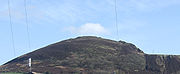
, or had had a less common name, "it might have been chosen as the new name" for the new district. The eight other towns objected, adamant that "a new name should be found". Thirty suggestions were put forward, including Brigantia, Clarendon, Hartshead, Kayborough, Tame, Ninetowns, and West Pennine, with Hartshead (with reference to Hartshead Pike
) being the most popular throughout most of the consultation period. However, the name Tameside (with reference to the River Tame) won 15 votes to Hartshead's 10 in a final stage of voting.
The borough underwent a boundary review in 2002. The review altered the areas covered by some wards to ensure councillors represented roughly equal numbers. Between 12 October 2006–8 January 2007, a dispersal order was enforced in the Dukinfield and Newton Hyde areas of the borough. The move was designed to reduce anti-social behaviour. A representative of Stalybridge police post said "Due to the serious nature of recent incidents in Dukinfield and Newton Hyde involving a number of confrontations between large groups of youths, the decision has been made to introduce a Dispersal Order".
 Tameside is bordered by the metropolitan borough
s of Stockport
and Oldham
to the south and north respectively, the city of Manchester to the west and the borough
of High Peak in Derbyshire
to the east. Tameside features flat lowlands in the west and highlands in the east where the western edge of the Pennines
encroaches on the borough. The hills in the east include Hartshead Pike
and Werneth Low
which is also a country park. As well as coal measures running north-south through the centre of the borough, there are areas of peat in the north east and there are large areas of boulder clay
all over Tameside. Ashton Moss is a peat bog covering about 107 hectares (264.4 acre) and Denton Moor is an area of about 81 hectares (200.2 acre) of peat.
 Waterways in Tameside include the rivers Medlock
and Etherow
, which form parts of Tameside's western and eastern boundaries respectively, and the River Tame crosses the borough north to south, giving Tameside its name. The Ashton Canal
, the Hollinwood Branch Canal
, the Huddersfield Narrow Canal
, and the Peak Forest Canal all run through the borough. There are also several reservoir
s, including the Audenshaw Reservoirs
. Greenspace
accounts for 63.5% of the Tameside's total area, domestic buildings and gardens comprise 17.4%, and the rest is made up of roads and non-domestic buildings.
Localities within the boundaries of Tameside include: Ashton-under-Lyne
, Audenshaw
, Broadbottom
, Carrbrook
, Copley
, Denton
, Droylsden
, Dukinfield
, Flowery Field
, Gee Cross
, Godley, Godley Green, Guide Bridge
, Hartshead Green, Hattersley
, Haughton Green
, Hazelhurst, Heyrod
, Hollingworth
, Hyde
, Landslow Green, Luzley, Millbrook
, Mossley
, Mottram in Longdendale
, Newton, Park Bridge
, Roe Cross, Stalybridge
, Warhill, and Woolley Bridge
.
, which also includes parts of the Metropolitan Borough of Oldham
, is represented by Mr. David Heyes
MP (Labour
). Denton and Reddish, which also covers parts of the Metropolitan Borough of Stockport
, is represented by Mr. Andrew Gwynne
MP (Labour). Stalybridge and Hyde, which is entirely within Tameside, is represented by Mr. Jonathan Reynolds
MP (Labour). Tameside is part of the North West England
constituency in the European Parliament
. North West England elects eight MEPs, as at 2009 made up of three Conservatives, two from the Labour Party, one member of the United Kingdom Independence Party
, one Liberal Democrat
, and one member of the BNP.
, Tameside Council is controlled by Labour
with the majority of 44 seats, second is the Conservative party
with 10 seats, third is taken by 3 independents
in Mossley. The Leader of the Council is Councillor Kieran Quinn.
Tameside Borough Council was assessed by the Audit Commission
and judged to be "improving strongly" in providing services for local people. Overall the council was awarded "four star" status meaning it was "performing strongly" and "well above minimum requirements", putting it in the top 38% of all local authorities.
Civil parish
es form the bottom tier of local government; the parish councils are involved in planning, management of town and parish centres, and promoting tourism. Mossley
is the only civil parish in Tameside, in 2001 9,856 people lived there, 4.6% of the borough's population. Prior to becoming a civil parish, it was a Municipal Borough
. The unparished areas are: Ashton-under-Lyne
(Municipal Borough), Audenshaw
(Urban District
), Denton
(Urban District), Droylsden
(Urban District), Dukinfield
(Municipal Borough), Hyde
(Municipal Borough), Longdendale
(Urban District), and Stalybridge
(Municipal Borough). The status of each area prior to 1974 is shown in brackets. An urban district was a type of local government district which covered an urbanised area. Ashton-under-Lyne, Audenshaw, Denton, Droylsden, and Mossley were previously in Lancashire and Dukinfield, Hyde, Longdendale, and Stalybridge were in Cheshire.
As of the 2001 UK census
, the Metropolitan Borough of Tameside had a total population of 213,043.
Of the 89,981 households in Tameside, 35.7% were married couples living together, 31.0% were one-person households, 7.8% were co-habiting
couples and 9.3% were lone parents, following a similar trend to the rest of England.
The population density was 2065 /km2 and for every 100 females, there were 94.2 males. Of those aged 16–74 in Tameside, 35.2% had no academic qualifications, significantly higher than 28.9% in all of England. 4.8% of Tameside's residents were born outside the United Kingdom, significantly lower than the national average of 9.2%. The largest minority group was Asian, at 4.0% of the population.
In 1841, 8.5% of Tameside's population was middle class
compared to 14% in England and Wales; this increased to 13.1% in 1931 (15% nationally) and 37.0% in 2001 (48% nationally). From 1841 to 1991, the working class
population of Tameside and across the country was in decline, falling steadily from 58.0% (36% nationally) to 22.8% in 1991 (21% nationally). It has since increased slightly, up to 32.9% (26% nation-wide). The rest of the population was made up of clerical workers and skilled manual workers.
As of the 2001 UK census, 75.5% of Tameside's residents reported themselves as being Christian, 2.5% Muslim, 1.4% Hindu, and 0.1% Buddhist. 12.1% had no religion, 0.2% had an alternative religion and 8.1% did not state their religion. Tameside is covered by the Catholic Dioceses of Shrewsbury and Salford, and the Church of England Diocese of Manchester
.
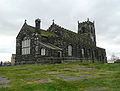
There are two Grade I listed churches in Tameside, St Anne's Church
, in Haughton, was built in 1881 in the Gothic Revival
style by J Medland Taylor. St Michael and All Angels' Church
in Ashton-under-Lyne
is a 15th century parish church which was virtually rebuilt in the 19th century. A church on the site dates back to at least 1262. St Lawrence's Church
, in Denton, is a Grade II* listed building and a timber framed church. It was remodelled by J Medland Taylor in 1872.
 The Ashton Arcades
shopping centre opened in 1995. The centre covers 13000 square metres (139,930.8 sq ft) on two floors with over 40 shops. In 2006, after failing twice to gain permission to develop a site in the neighbouring borough of Stockport
, IKEA
announced plans to build its first town centre-store in Ashton-under-Lyne. The store is expected to create 500 new jobs as well as attract other businesses to the area. The store opened on 19 October 2006 and covers 27500 square metres (296,007.5 sq ft) At the time of its creation, the store was the tallest in Britain. Life science industries have been identified as growth industries in Greater Manchester and are concentrated in Oldham and Tameside. Average house prices in Tameside are the 7th highest out of the ten metropolitan boroughs in Greater Manchester, 11.9% below the average for the county.
As of the 2001 UK census, Tameside had 152,313 residents aged 16 to 74. 2.0% of these people were students with jobs, 5.7% looking after home or family, 7.9% permanently sick or disabled and 3.2% economically inactive for other reasons.
In 2001, of 96,255 residents of Tameside in employment, the industry of employment was 21.7% manufacturing, 10.4% health and social work, 18.2% retail and wholesale, 10.2% property and business services, 7.2% construction, 6.8% transport and communications, 6.4% education, 5.3% public administration and defence, 4.2% finance, 4.0% hotels and restaurants, 0.9% energy and water supply, 0.5% agriculture, and 4.0% other. This was roughly in line with national figures, except for the proportion of jobs in agriculture which is less than half the national average, and property which was also below the national average. Manufacturing was 50% more than the national average.
 In February 2001, Tameside had one Grade I listed buildings
, 19 Grade II*, and 289 Grade II. The number of Grade I listed buildings in Tameside has increased to three, these are St Anne's Church
in Haughton; St Michael and All Angels' Church
in Ashton-under-Lyne
; and Fairbottom Farm Barn, a 17th century farm building. In Tameside are three of Greater Manchester's Sites of Special Scientific Interest, Boar Flat, part of Dark Peak
, the Hollinwood Branch Canal
and the Huddersfield Narrow Canal
. The Huddersfield Narrow Canal runs for from Huddersfield
to Ashton-under-Lyne
; it is protected for its biological interest, and is "the best example of a flowing eutrophic water system in Greater Manchester".
There are three Scheduled Ancient Monuments
in the borough, a Bronze Age
cairn
in Stalybridge, Buckton Castle
, and Nico Ditch
. Buckton Castle is a 12th century ringwork near Carrbrook
. It was probably built for William de Neville and was the centre of lordship of Longdendale
. The castle lay ruinous by 1360, and has been described as "one of England's most important castles". Nico Ditch is an earthwork
running from Ashton-under-Lyne
in the east to Stretford
in the west, in the borough of Trafford
. It survives to a depth of 1.5 metres (4.9 ft) in some places and is up to 4 metres (13.1 ft) wide. Tameside also has nine conservation areas: Ashton and Stalybridge town centres; Carrbrook, Copley St.Paul's, and Millbrook in Stalybridge; Fairfield in Droylsden; Mottram-in-Longdendale; Portland Basin
; and St.Anne's in Haughton.
The Museum of the Manchester Regiment is housed in Ashton-under-Lyne's town hall. The museum displays relics related to the Manchester Regiment including five Victoria Cross
es awarded to members of the regiment. Park Bridge Heritage Centre in the Medlock Valley is a museum dedicated to the history of the settlement of Park Bridge and its industry. Broad Mills Heritage Site, in Broadbottom, preserves the remains of an early 19th century textile works. Art galleries in the borough include Astley Cheetham Art Gallery in Stalybridge and Central Art Gallery in Ashton-under-Lyne.
Tameside has eight designated Local Nature Reserve
s which are Knott Hill, Hollinwood Branch Canal, Great Wood, Haughton Dale, Hulmes and Hardy Woods, Castle Clough and Cowbury Dale, Hurst Clough and Rocher Vale. Four more are to be designated.
in SATs performance – and 5th in Greater Manchester. Authorised absences from and unauthorised absences from Tameside secondary schools in 2006–07 were 6.0% and 0.4%, lower than the national average (7.8% and 1.4%). In 2007, the Tameside LEA was ranked 100th out of 148 in the country – and 6th in Greater Manchester – based on the percentage of pupils attaining at least 5 A*-C grades at GCSE including maths and English (41.8% compared with the national average of 46.7%). In 2007, Audenshaw School
was the most successful school in Tameside at both GCSE and A–level; 64% of the pupils gaining five or more GCSEs at A*-C grade including maths and English. The secondary schools in Tameside are Alder Community High School
, All Saints Catholic College
, Astley Sports College, Audenshaw School, Copley High School, Denton Community College
, Droylsden Academy, Fairfield High School for Girls
, Hyde Technology School, Longdendale Community Language College
, Mossley Hollins High School
, New Charter Academy, St Damian's RC Science College, St Thomas More RC High School and West Hill School
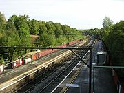 Tameside is served by 13 train stations. Denton railway station
is on the Stockport to Stalybridge Line
. Fairfield railway station, Guide Bridge railway station
, Hyde Central railway station
, and Hyde North railway station
are all on the Hope Valley Line
between Sheffield
and Manchester. Broadbottom railway station
, Flowery Field railway station
, Godley railway station
, Guide Bridge railway station, Hattersley railway station
, and Newton for Hyde railway station
are served by the Glossop Line between Glossop and Manchester. Ashton-under-Lyne railway station
, Mossley railway station
, and Stalybridge railway station
are on the Huddersfield Line
.
Work on an extension of the Manchester Metrolink
costing £260M is expected to begin in 2008. The original plan was to extend the metrolink to Ashton-under-Lyne, but due to reduced funding from the government, the plans were scaled back and it was planned that the extension would go only as far as Droylsden. However, work has started to bring the Metrolink to Ashton centre; currently work has extended to Lord Sheldon Way.
Tameside council is responsible for maintaining the public rights of way in the borough, including 145 mi (233.4 km) of footpaths. In 2003, the government passed a scheme to create a bypass between the M67 and the A628. The Longdendale Bypass
is expected to cost between £240M and £315M and although it received support from the communities effected by the bypass in the form of a petition with 9,000 signatures, the scheme ran into opposition. A enquiry was launched in 2007, costing £15M, however the fate of the bypass remains undecided.
The arrangement with Mutare
in Zimbabwe has been suspended due to the political unrest in that country. Some localities were originally twinned with a place within the Metropolitan Borough prior to its creation in 1974.
Metropolitan borough
A metropolitan borough is a type of local government district in England, and is a subdivision of a metropolitan county. Created in 1974 by the Local Government Act 1972, metropolitan boroughs are defined in English law as metropolitan districts, however all of them have been granted or regranted...
of Greater Manchester
Greater Manchester
Greater Manchester is a metropolitan county in North West England, with a population of 2.6 million. It encompasses one of the largest metropolitan areas in the United Kingdom and comprises ten metropolitan boroughs: Bolton, Bury, Oldham, Rochdale, Stockport, Tameside, Trafford, Wigan, and the...
in North West England
North West England
North West England, informally known as The North West, is one of the nine official regions of England.North West England had a 2006 estimated population of 6,853,201 the third most populated region after London and the South East...
. It is named after the River Tame
River Tame, Greater Manchester
The River Tame flows through Greater Manchester, England.-Source:The Tame rises on Denshaw Moor in Greater Manchester, close to the border with West Yorkshire but within the historic West Riding of Yorkshire.-Course:...
which flows through the borough and spans the towns of Ashton-under-Lyne
Ashton-under-Lyne
Ashton-under-Lyne is a market town in the Metropolitan Borough of Tameside, Greater Manchester, England. Historically a part of Lancashire, it lies on the north bank of the River Tame, on undulating land at the foothills of the Pennines...
, Audenshaw
Audenshaw
Audenshaw is a town within the Metropolitan Borough of Tameside, in Greater Manchester, England. It is located on the east side of the River Tame, along the course of both the M60 motorway and the Ashton Canal, southwest of Ashton-under-Lyne and east of the city of Manchester...
, Denton
Denton, Greater Manchester
Denton is a town within the Metropolitan Borough of Tameside, in Greater Manchester, England. It is five miles to the east of Manchester city centre, and has a population of 26,866....
, Droylsden
Droylsden
Droylsden is a town within the Metropolitan Borough of Tameside, in Greater Manchester, England. It is to the east of Manchester city centre, and west-southwest of Ashton-under-Lyne, it has a population of 23,172....
, Dukinfield
Dukinfield
Dukinfield is a small town within the Metropolitan Borough of Tameside, in Greater Manchester, England. It lies in central Tameside on the south bank of the River Tame, opposite Ashton-under-Lyne, and is east of the city of Manchester...
, Hyde
Hyde, Greater Manchester
Hyde is a town in the Metropolitan Borough of Tameside, Greater Manchester, England. As of the 2001 census, the town had a population of 31,253. Historically part of Cheshire, it is northeast of Stockport, west of Glossop and east of Manchester....
, Mossley
Mossley
Mossley is a small town and civil parish within the Metropolitan Borough of Tameside, in Greater Manchester, England. The town is located in the upper section of the Tame valley in the foothills of the Pennines, northeast of Ashton-under-Lyne and east of Manchester.Mossley has the distinction of...
and Stalybridge
Stalybridge
Stalybridge is a town in the Metropolitan Borough of Tameside in Greater Manchester, England, with a population of 22,568. Historically a part of Cheshire, it is east of Manchester city centre and northwest of Glossop. With the construction of a cotton mill in 1776, Stalybridge became one of...
. Its western border is approximately 4 miles (6.4 km) east of Manchester city centre
Manchester City Centre
Manchester city centre is the central business district of Manchester, England. It lies within the Manchester Inner Ring Road, next to the River Irwell...
. It borders Derbyshire
Derbyshire
Derbyshire is a county in the East Midlands of England. A substantial portion of the Peak District National Park lies within Derbyshire. The northern part of Derbyshire overlaps with the Pennines, a famous chain of hills and mountains. The county contains within its boundary of approx...
to the east, the Metropolitan Borough of Oldham
Metropolitan Borough of Oldham
The Metropolitan Borough of Oldham is a metropolitan borough of Greater Manchester, England. It has a population of 219,600, and spans . The borough is named after its largest town, Oldham, but also includes the outlying towns of Chadderton, Failsworth, Royton and Shaw and Crompton, the village of...
to the north, the Metropolitan Borough of Stockport
Metropolitan Borough of Stockport
The Metropolitan Borough of Stockport is a metropolitan borough of Greater Manchester, in north west England, centred around the town of Stockport. It has a population of about 280,600 and includes the outyling areas of Cheadle and Cheadle Hulme, Marple, Bredbury, Reddish and Romiley...
to the south, and the City of Manchester
Manchester
Manchester is a city and metropolitan borough in Greater Manchester, England. According to the Office for National Statistics, the 2010 mid-year population estimate for Manchester was 498,800. Manchester lies within one of the UK's largest metropolitan areas, the metropolitan county of Greater...
to the west. Tameside has a population of 214,400.
The history of the area extends back to the Stone Age
Stone Age
The Stone Age is a broad prehistoric period, lasting about 2.5 million years , during which humans and their predecessor species in the genus Homo, as well as the earlier partly contemporary genera Australopithecus and Paranthropus, widely used exclusively stone as their hard material in the...
. There are over 300 listed buildings in Tameside and three Scheduled Ancient Monument
Scheduled Ancient Monument
In the United Kingdom, a scheduled monument is a 'nationally important' archaeological site or historic building, given protection against unauthorized change. The various pieces of legislation used for legally protecting heritage assets from damage and destruction are grouped under the term...
s, which includes a castle
Buckton Castle
Buckton Castle is a medieval ringwork near Carrbrook, Stalybridge, England. It is listed as a Scheduled Ancient Monument due to its proximity to the Buckton Vale Quarry. The castle is oval, with a stone curtain wall wide, surrounded by a ditch wide and deep. Buckton Castle was probably...
of national importance. The settlements in Tameside were small townships centred around agriculture until the advent of the Industrial Revolution
Industrial Revolution
The Industrial Revolution was a period from the 18th to the 19th century where major changes in agriculture, manufacturing, mining, transportation, and technology had a profound effect on the social, economic and cultural conditions of the times...
. The towns of the borough grew and became involved in the cotton industry, which dominated the local economy. The current borough was created in 1974 as part of the provisions of the Local Government Act 1972
Local Government Act 1972
The Local Government Act 1972 is an Act of Parliament in the United Kingdom that reformed local government in England and Wales on 1 April 1974....
. Since then the area has been administered by Tameside Borough Council, which has been judged by the Audit Commission
Audit Commission
The Audit Commission is a public corporation in the United Kingdom.The Commission’s primary objective is to improve economy, efficiency and effectiveness in local government, housing and the health service, directly through the audit and inspection process and also through value for money...
to be "performing strongly".
History
The history of the area stretches back up to 10,000 years; there are 22 MesolithicMesolithic
The Mesolithic is an archaeological concept used to refer to certain groups of archaeological cultures defined as falling between the Paleolithic and the Neolithic....
sites in Tameside, the oldest dating to around 8,000 BC; 21 of the 22 sites are in the hilly uplands in the north east of the borough. Evidence of Neolithic
Neolithic
The Neolithic Age, Era, or Period, or New Stone Age, was a period in the development of human technology, beginning about 9500 BC in some parts of the Middle East, and later in other parts of the world. It is traditionally considered as the last part of the Stone Age...
and Bronze Age
Bronze Age
The Bronze Age is a period characterized by the use of copper and its alloy bronze as the chief hard materials in the manufacture of some implements and weapons. Chronologically, it stands between the Stone Age and Iron Age...
activity is more limited in the borough, although the Bronze Age Stalybridge Cairn is the most complete prehistoric funerary monument in the borough. The people in the area changed from hunter-gatherers to farmers around 2500 BC–1500 BC due to climate change. Werneth Low is the most likely Iron Age
Iron Age
The Iron Age is the archaeological period generally occurring after the Bronze Age, marked by the prevalent use of iron. The early period of the age is characterized by the widespread use of iron or steel. The adoption of such material coincided with other changes in society, including differing...
farmstead site in the borough, probably dating to the late 1st millennium BC. Before the Roman conquest of Britain in the 1st century AD, the area was probably part of the territory of the Brigantes
Brigantes
The Brigantes were a Celtic tribe who in pre-Roman times controlled the largest section of what would become Northern England, and a significant part of the Midlands. Their kingdom is sometimes called Brigantia, and it was centred in what was later known as Yorkshire...
, the Celtic tribe controlling most of what is now north west England.
The area came under control of the Roman Empire
Roman Empire
The Roman Empire was the post-Republican period of the ancient Roman civilization, characterised by an autocratic form of government and large territorial holdings in Europe and around the Mediterranean....
in the second half of the 1st century. Roads through the area were established from Ardotalia
Ardotalia
Ardotalia is a Roman fort in Gamesley, near Glossop in Derbyshire, England .Ardotalia was constructed by Cohors Primae Frisiavonum—The First Cohort of Frisiavones. Evidence for the existence of this unit exists not only from the building stone found at the site but also from various diplomas and...
fort
Castra
The Latin word castra, with its singular castrum, was used by the ancient Romans to mean buildings or plots of land reserved to or constructed for use as a military defensive position. The word appears in both Oscan and Umbrian as well as in Latin. It may have descended from Indo-European to Italic...
in Derbyshire
Derbyshire
Derbyshire is a county in the East Midlands of England. A substantial portion of the Peak District National Park lies within Derbyshire. The northern part of Derbyshire overlaps with the Pennines, a famous chain of hills and mountains. The county contains within its boundary of approx...
to Mamucium (Manchester) west of Tameside and Castleshaw Roman fort
Castleshaw Roman fort
Castleshaw Roman fort was a fort in the Roman province of Britannia. Although there is no evidence to substantiate the claim, it has been suggested that Castleshaw Roman fort is the site of Rigodunum, a Brigantian settlement. The remains of the fort are located on Castle Hill on the eastern side of...
in the north. Romano-British finds in the borough include a bog body
Bog body
Bog bodies, which are also known as bog people, are the naturally preserved human corpses found in the sphagnum bogs in Northern Europe. Unlike most ancient human remains, bog bodies have retained their skin and internal organs due to the unusual conditions of the surrounding area...
in Ashton Moss, occupation sites at Werneth Low, Harridge Pike, Roe Cross, and Mottram. A 4th century coin hoard was found in Denton and is one of only four hoards from the 4th century in the Mersey basin. A Byzantine coin from the 6th or 7th centuries, also found in Denton, indicates continued or renewed occupation once the Romans left Britain in the early 5th century.
Nico Ditch, an earthwork stretching from Stretford to Ashton-under-Lyne, is evidence of Anglo-Saxon
Anglo-Saxon
Anglo-Saxon may refer to:* Anglo-Saxons, a group that invaded Britain** Old English, their language** Anglo-Saxon England, their history, one of various ships* White Anglo-Saxon Protestant, an ethnicity* Anglo-Saxon economy, modern macroeconomic term...
activity in Tameside. It was probably dug between the 7th and 9th centuries and may have been used as a boundary between the kingdoms of Mercia
Mercia
Mercia was one of the kingdoms of the Anglo-Saxon Heptarchy. It was centred on the valley of the River Trent and its tributaries in the region now known as the English Midlands...
and Northumbria
Northumbria
Northumbria was a medieval kingdom of the Angles, in what is now Northern England and South-East Scotland, becoming subsequently an earldom in a united Anglo-Saxon kingdom of England. The name reflects the approximate southern limit to the kingdom's territory, the Humber Estuary.Northumbria was...
. Further evidence of Anglo-Saxon era activity in Tameside comes from the derivation of settlement names from Old English such as -tun, meaning farmstead, and leah meaning clearing.
According to the Domesday Survey of 1086, Tameside was divided into four manors
Manorialism
Manorialism, an essential element of feudal society, was the organizing principle of rural economy that originated in the villa system of the Late Roman Empire, was widely practiced in medieval western and parts of central Europe, and was slowly replaced by the advent of a money-based market...
, those of Tintwistle, Hollingworth, Werneth, and Mottram. The land east or the River Tame was in the Hundred of Hamestan
Hundreds of Cheshire
The Hundreds of Cheshire, as with other Hundreds in England were the geographic divisions of Cheshire for administrative, military and judicial purposes. They were introduced in Cheshire some time before the Norman conquest...
in Cheshire and held by the Earl of Chester
Earl of Chester
The Earldom of Chester was one of the most powerful earldoms in medieval England. Since 1301 the title has generally been granted to heirs-apparent to the English throne, and from the late 14th century it has been given only in conjunction with that of Prince of Wales.- Honour of Chester :The...
while to the west of the river was in the Hundred of Salford
Salford (hundred)
The hundred of Salford was an ancient division of the historic county of Lancashire, in Northern England. It was sometimes known as Salfordshire, the name alluding to its judicial centre being the township of Salford...
under Roger de Poitevin
Roger the Poitevin
Roger the Poitevin was born in Normandy in the mid-1060s and died before 1140 . He was an Anglo-Norman aristocrat, who possessed large holdings in both England and through his marriage in France....
. These manors were divided to create further manors, so that by the 13th century. Most of them were owned by local families and remained in the hands of the same families until the 16th century. Manorialism continued as the main for of administration and governance until the mid-19th century.
The Industrial Revolution had a significant impact on Tameside; the area, whose main towns had previously been Ashton-under-Lyne and Mottram-in-Longdendale, was transformed from a collection of the rural, farming communities into mill town
Mill town
A mill town, also known as factory town or mill village, is typically a settlement that developed around one or more mills or factories .- United Kingdom:...
s. The towns of Ashton-under-Lyne, Dukinfield, Hyde, Mossley and Stalybridge have been described as "amongst the most famous mills towns in the North West". With only a brief interruption for the Lancashire Cotton Famine of 1861 to 1865, factories producing and processing textiles were the main industry in Tameside from the late-18th century until the mid-20th century.
In 1964, Dukinfield Borough Council convened a meeting of neighbouring local authorities with the aim of formulating a policy of cross-authority social improvement for the districts in the Tame Valley. Following deindustrialisation, the area had suffered "gross-neglect" and had large areas of housing unsuitable for human habitation. This joint enterprise comprised the nine districts that would become Tameside ten years later, plus the County Borough of Stockport
County Borough of Stockport
Stockport was a local government district centred on Stockport in the northwest of England from 1835 to 1974.The district was created by the Municipal Corporations Act 1835 when the existing Borough of Stockport was reformed as a municipal borough. Until 1835 the town was governed by a charter...
. This collective agreed on creating "a linear park in the valley [of the River Tame] for the use of the townspeople and as a major recreational resource within the Manchester metropolis".
Tameside was created on 1 April 1974, by the Local Government Act 1972
Local Government Act 1972
The Local Government Act 1972 is an Act of Parliament in the United Kingdom that reformed local government in England and Wales on 1 April 1974....
as one of the ten metropolitan districts of Greater Manchester. It took over the local government functions of nine districts which were formerly in the administrative counties
Administrative counties of England
Administrative counties were a level of subnational division of England used for the purposes of local government from 1889 to 1974. They were created by the Local Government Act 1888 as the areas for which county councils were elected. Some large counties were divided into several administrative...
of Lancashire
Lancashire
Lancashire is a non-metropolitan county of historic origin in the North West of England. It takes its name from the city of Lancaster, and is sometimes known as the County of Lancaster. Although Lancaster is still considered to be the county town, Lancashire County Council is based in Preston...
and of Cheshire
Cheshire
Cheshire is a ceremonial county in North West England. Cheshire's county town is the city of Chester, although its largest town is Warrington. Other major towns include Widnes, Congleton, Crewe, Ellesmere Port, Runcorn, Macclesfield, Winsford, Northwich, and Wilmslow...
. In 1986 Tameside effectively became a unitary authority
Unitary authority
A unitary authority is a type of local authority that has a single tier and is responsible for all local government functions within its area or performs additional functions which elsewhere in the relevant country are usually performed by national government or a higher level of sub-national...
with the abolition of the Greater Manchester County Council
Greater Manchester County Council
The Greater Manchester County Council — also known as the Greater Manchester Council — was the top-tier local government administrative body for Greater Manchester from 1974 to 1986...
.
A name for the metropolitan borough proved problematic. The Redcliffe-Maud Report
Redcliffe-Maud Report
The Redcliffe–Maud Report is the name generally given to the report published by the Royal Commission on Local Government in England 1966–1969 under the chairmanship of Lord Redcliffe-Maud.-Terms of reference and membership:...
had used the name Ashton-Hyde, but double-barrelled names were prohibited for the new districts. Had Ashton-under-Lyne been a county borough
County borough
County borough is a term introduced in 1889 in the United Kingdom of Great Britain and Ireland , to refer to a borough or a city independent of county council control. They were abolished by the Local Government Act 1972 in England and Wales, but continue in use for lieutenancy and shrievalty in...
, or had had a less common name, "it might have been chosen as the new name" for the new district. The eight other towns objected, adamant that "a new name should be found". Thirty suggestions were put forward, including Brigantia, Clarendon, Hartshead, Kayborough, Tame, Ninetowns, and West Pennine, with Hartshead (with reference to Hartshead Pike
Hartshead Pike
Hartshead Pike is a hill in Tameside in Greater Manchester, England. The name is however more commonly associated with the monument on its summit. It overlooks Ashton-under-Lyne, Mossley and Oldham.-History:...
) being the most popular throughout most of the consultation period. However, the name Tameside (with reference to the River Tame) won 15 votes to Hartshead's 10 in a final stage of voting.
The borough underwent a boundary review in 2002. The review altered the areas covered by some wards to ensure councillors represented roughly equal numbers. Between 12 October 2006–8 January 2007, a dispersal order was enforced in the Dukinfield and Newton Hyde areas of the borough. The move was designed to reduce anti-social behaviour. A representative of Stalybridge police post said "Due to the serious nature of recent incidents in Dukinfield and Newton Hyde involving a number of confrontations between large groups of youths, the decision has been made to introduce a Dispersal Order".
Geography
Metropolitan borough
A metropolitan borough is a type of local government district in England, and is a subdivision of a metropolitan county. Created in 1974 by the Local Government Act 1972, metropolitan boroughs are defined in English law as metropolitan districts, however all of them have been granted or regranted...
s of Stockport
Metropolitan Borough of Stockport
The Metropolitan Borough of Stockport is a metropolitan borough of Greater Manchester, in north west England, centred around the town of Stockport. It has a population of about 280,600 and includes the outyling areas of Cheadle and Cheadle Hulme, Marple, Bredbury, Reddish and Romiley...
and Oldham
Metropolitan Borough of Oldham
The Metropolitan Borough of Oldham is a metropolitan borough of Greater Manchester, England. It has a population of 219,600, and spans . The borough is named after its largest town, Oldham, but also includes the outlying towns of Chadderton, Failsworth, Royton and Shaw and Crompton, the village of...
to the south and north respectively, the city of Manchester to the west and the borough
Borough
A borough is an administrative division in various countries. In principle, the term borough designates a self-governing township although, in practice, official use of the term varies widely....
of High Peak in Derbyshire
Derbyshire
Derbyshire is a county in the East Midlands of England. A substantial portion of the Peak District National Park lies within Derbyshire. The northern part of Derbyshire overlaps with the Pennines, a famous chain of hills and mountains. The county contains within its boundary of approx...
to the east. Tameside features flat lowlands in the west and highlands in the east where the western edge of the Pennines
Pennines
The Pennines are a low-rising mountain range, separating the North West of England from Yorkshire and the North East.Often described as the "backbone of England", they form a more-or-less continuous range stretching from the Peak District in Derbyshire, around the northern and eastern edges of...
encroaches on the borough. The hills in the east include Hartshead Pike
Hartshead Pike
Hartshead Pike is a hill in Tameside in Greater Manchester, England. The name is however more commonly associated with the monument on its summit. It overlooks Ashton-under-Lyne, Mossley and Oldham.-History:...
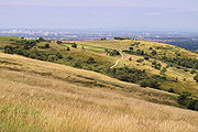
and Werneth Low
Werneth Low
Werneth Low is a hill in Greater Manchester, England, and a part of the Pennines. It is located on the borders of Stockport and Tameside and rises to height of...
which is also a country park. As well as coal measures running north-south through the centre of the borough, there are areas of peat in the north east and there are large areas of boulder clay
Boulder clay
Boulder clay, in geology, is a deposit of clay, often full of boulders, which is formed in and beneath glaciers and ice-sheets wherever they are found, but is in a special sense the typical deposit of the Glacial Period in northern Europe and North America...
all over Tameside. Ashton Moss is a peat bog covering about 107 hectares (264.4 acre) and Denton Moor is an area of about 81 hectares (200.2 acre) of peat.
River Medlock
The River Medlock is a river of Greater Manchester in North West England. It rises near Oldham and flows, south and west, for ten miles to join the River Irwell in the extreme southwest of Manchester city centre.-Source:...
and Etherow
River Etherow
The River Etherow is a river in northern England, and a tributary of the River Goyt. Although now passing through South Yorkshire, Derbyshire and Greater Manchester, it historically formed the ancient county boundary between Cheshire and Derbyshire. The upper valley is known as Longdendale...
, which form parts of Tameside's western and eastern boundaries respectively, and the River Tame crosses the borough north to south, giving Tameside its name. The Ashton Canal
Ashton Canal
The Ashton Canal is a canal built in Greater Manchester in North West England.-Route:The Ashton leaves the Rochdale Canal at Ducie St. Junction in central Manchester, and climbs for through 18 locks, passing through Ancoats, Holt Town, Bradford-with-Beswick, Clayton, Openshaw, Droylsden,...
, the Hollinwood Branch Canal
Hollinwood Branch Canal
The Hollinwood Branch Canal was a canal near Hollinwood, in Oldham, England. It left the main line of the Ashton Canal at Fairfield Junction immediately above lock 18. It was just over long and went through...
, the Huddersfield Narrow Canal
Huddersfield Narrow Canal
The Huddersfield Narrow Canal is an inland waterway in northern England. It runs just under from Lock 1E at the rear of the University of Huddersfield campus, near Aspley Basin at Huddersfield to the junction with the Ashton Canal at Whitelands Basin in Ashton-under-Lyne...
, and the Peak Forest Canal all run through the borough. There are also several reservoir
Reservoir
A reservoir , artificial lake or dam is used to store water.Reservoirs may be created in river valleys by the construction of a dam or may be built by excavation in the ground or by conventional construction techniques such as brickwork or cast concrete.The term reservoir may also be used to...
s, including the Audenshaw Reservoirs
Audenshaw Reservoirs
The Audenshaw Reservoirs were constructed between 1877 and 1882 by Manchester Corporation. They are located in the townships of Audenshaw and Denton, Greater Manchester, in northern England. Their construction was overseen by John Frederick Bateman. Part of the original village of Audenshaw was...
. Greenspace
Green belt
A green belt or greenbelt is a policy and land use designation used in land use planning to retain areas of largely undeveloped, wild, or agricultural land surrounding or neighbouring urban areas. Similar concepts are greenways or green wedges which have a linear character and may run through an...
accounts for 63.5% of the Tameside's total area, domestic buildings and gardens comprise 17.4%, and the rest is made up of roads and non-domestic buildings.
Localities within the boundaries of Tameside include: Ashton-under-Lyne
Ashton-under-Lyne
Ashton-under-Lyne is a market town in the Metropolitan Borough of Tameside, Greater Manchester, England. Historically a part of Lancashire, it lies on the north bank of the River Tame, on undulating land at the foothills of the Pennines...
, Audenshaw
Audenshaw
Audenshaw is a town within the Metropolitan Borough of Tameside, in Greater Manchester, England. It is located on the east side of the River Tame, along the course of both the M60 motorway and the Ashton Canal, southwest of Ashton-under-Lyne and east of the city of Manchester...
, Broadbottom
Broadbottom
Broadbottom is a suburban village within the Metropolitan Borough of Tameside in Greater Manchester, England. It lies within the ancient county boundaries of Cheshire, by the River Etherow, on Greater Manchester's border with Derbyshire.-Description:...
, Carrbrook
Carrbrook
Carrbrook is an area in the east of Stalybridge, in Greater Manchester, England. The area still has many seventeenth and eighteenth century buildings. Much of the late-nineteenth and early-twentieth century village was built during the industrial boom brought by the printworks. Modern Housing...
, Copley
Copley, Greater Manchester
Copley is an area of the town of Stalybridge, which lies at the foot of the Pennines, 8 miles east of Manchester in Greater Manchester, England. The area has a local secondary school which is attached to a local recreational centre and swimming pool....
, Denton
Denton, Greater Manchester
Denton is a town within the Metropolitan Borough of Tameside, in Greater Manchester, England. It is five miles to the east of Manchester city centre, and has a population of 26,866....
, Droylsden
Droylsden
Droylsden is a town within the Metropolitan Borough of Tameside, in Greater Manchester, England. It is to the east of Manchester city centre, and west-southwest of Ashton-under-Lyne, it has a population of 23,172....
, Dukinfield
Dukinfield
Dukinfield is a small town within the Metropolitan Borough of Tameside, in Greater Manchester, England. It lies in central Tameside on the south bank of the River Tame, opposite Ashton-under-Lyne, and is east of the city of Manchester...
, Flowery Field
Flowery Field
Flowery Field is an area of Hyde, Greater Manchester, North West England.It is a mainly residential area once dominated by Ashton Brothers Textile Mill.-Cricket:...
, Gee Cross
Gee Cross
Gee Cross is a suburban village within the Metropolitan Borough of Tameside, in Greater Manchester, England. It lies at the edge of the town of Hyde and borders onto Woodley in the Metropolitan Borough of Stockport...
, Godley, Godley Green, Guide Bridge
Guide Bridge
Guide Bridge is an area of Audenshaw, in the Metropolitan Borough of Tameside, Greater Manchester, England. Historically a part of Lancashire, Guide Bridge formed as a village built around an eponymous bridge over the Ashton Canal and lies west of the town of Ashton-under-Lyne.-History:Industries...
, Hartshead Green, Hattersley
Hattersley
Hattersley is a residential area within the Metropolitan Borough of Tameside, in Greater Manchester, England. It is to the east of Hyde and 6 miles west of the Peak District National Park....
, Haughton Green
Haughton Green
Haughton Green is a large village in Tameside, Greater Manchester, England. It formed part of the ancient township of Haughton, Lancashire, along with Haughton Dale, Higher Haughton, Lower Haughton, Haughton Hall and Haughton itself....
, Hazelhurst, Heyrod
Heyrod
Heyrod is a suburban village in the Metropolitan Borough of Tameside, Greater Manchester, England. It is between Stalybridge and Mossley.In contrast to the rest of Stalybridge, which was anciently a part of Cheshire, Heyrod was formerly a part of Lancashire...
, Hollingworth
Hollingworth
Hollingworth is a village within the Metropolitan Borough of Tameside, in Greater Manchester, England. It is about twelve miles east of Manchester on the Derbyshire border at Glossop...
, Hyde
Hyde, Greater Manchester
Hyde is a town in the Metropolitan Borough of Tameside, Greater Manchester, England. As of the 2001 census, the town had a population of 31,253. Historically part of Cheshire, it is northeast of Stockport, west of Glossop and east of Manchester....
, Landslow Green, Luzley, Millbrook
Millbrook, Greater Manchester
Millbrook is a village near Stalybridge, northwest England. It is part of the Stalybridge South ward of Tameside metropolitan borough.-History:...
, Mossley
Mossley
Mossley is a small town and civil parish within the Metropolitan Borough of Tameside, in Greater Manchester, England. The town is located in the upper section of the Tame valley in the foothills of the Pennines, northeast of Ashton-under-Lyne and east of Manchester.Mossley has the distinction of...
, Mottram in Longdendale
Mottram in Longdendale
Mottram in Longdendale is an unparished village within the Metropolitan Borough of Tameside, in Greater Manchester, England. It lies in the valley of Longdendale, on the border with Derbyshire and close to the Peak District neighbouring Broadbottom and Hattersley. Mottram in Longdendale Parish was...
, Newton, Park Bridge
Park Bridge
Park Bridge is an area of Ashton-under-Lyne, in the Metropolitan Borough of Tameside, in Greater Manchester, England. It is situated in the Medlock Valley, by Ashton-under-Lyne's border with Oldham. Park Bridge anciently lay within medieval manor of Ashton, however there is no record of Park Bridge...
, Roe Cross, Stalybridge
Stalybridge
Stalybridge is a town in the Metropolitan Borough of Tameside in Greater Manchester, England, with a population of 22,568. Historically a part of Cheshire, it is east of Manchester city centre and northwest of Glossop. With the construction of a cotton mill in 1776, Stalybridge became one of...
, Warhill, and Woolley Bridge
Woolley Bridge
Woolley Bridge is a village in Glossopdale,On the border with Greater Manchester and Derbyshire. It lies 10 miles from Manchester city center. England on the River Etherow.Nearby places include Hollingworth, Dinting Vale, Gamesley, Glossop and Mottram....
.
Parliamentary constituencies
The residents of the Tameside are represented in the United Kingdom Parliament by Members of Parliament (MPs) for three separate parliamentary constituencies. Ashton-under-LyneAshton-under-Lyne (UK Parliament constituency)
Ashton-under-Lyne is a constituency centred on the town of Ashton-under-Lyne that is represented in the House of Commons of the Parliament of the United Kingdom. It elects one Member of Parliament by the first past the post system of election...
, which also includes parts of the Metropolitan Borough of Oldham
Metropolitan Borough of Oldham
The Metropolitan Borough of Oldham is a metropolitan borough of Greater Manchester, England. It has a population of 219,600, and spans . The borough is named after its largest town, Oldham, but also includes the outlying towns of Chadderton, Failsworth, Royton and Shaw and Crompton, the village of...
, is represented by Mr. David Heyes
David Heyes
David Alan Heyes is a British Labour Party politician who has been the Member of Parliament for Ashton under Lyne since 2001.-Early life:...
MP (Labour
Labour Party (UK)
The Labour Party is a centre-left democratic socialist party in the United Kingdom. It surpassed the Liberal Party in general elections during the early 1920s, forming minority governments under Ramsay MacDonald in 1924 and 1929-1931. The party was in a wartime coalition from 1940 to 1945, after...
). Denton and Reddish, which also covers parts of the Metropolitan Borough of Stockport
Metropolitan Borough of Stockport
The Metropolitan Borough of Stockport is a metropolitan borough of Greater Manchester, in north west England, centred around the town of Stockport. It has a population of about 280,600 and includes the outyling areas of Cheadle and Cheadle Hulme, Marple, Bredbury, Reddish and Romiley...
, is represented by Mr. Andrew Gwynne
Andrew Gwynne
Andrew John Gwynne is a British Labour Party politician and has been the Member of Parliament for Denton and Reddish since 2005, replacing the retiring Andrew Bennett.-Early life:...
MP (Labour). Stalybridge and Hyde, which is entirely within Tameside, is represented by Mr. Jonathan Reynolds
Jonathan Reynolds
Jonathan Neil Reynolds is a British Labour Co-operative politician, who has been the Member of Parliament for Stalybridge and Hyde since 2010....
MP (Labour). Tameside is part of the North West England
North West England (European Parliament constituency)
North West England is a constituency of the European Parliament. For the 2009 elections it elects 8 MEPs using the d'Hondt method of party-list proportional representation.-Boundaries:...
constituency in the European Parliament
European Parliament
The European Parliament is the directly elected parliamentary institution of the European Union . Together with the Council of the European Union and the Commission, it exercises the legislative function of the EU and it has been described as one of the most powerful legislatures in the world...
. North West England elects eight MEPs, as at 2009 made up of three Conservatives, two from the Labour Party, one member of the United Kingdom Independence Party
United Kingdom Independence Party
The United Kingdom Independence Party is a eurosceptic and right-wing populist political party in the United Kingdom. Whilst its primary goal is the UK's withdrawal from the European Union, the party has expanded beyond its single-issue image to develop a more comprehensive party platform.UKIP...
, one Liberal Democrat
Liberal Democrats
The Liberal Democrats are a social liberal political party in the United Kingdom which supports constitutional and electoral reform, progressive taxation, wealth taxation, human rights laws, cultural liberalism, banking reform and civil liberties .The party was formed in 1988 by a merger of the...
, and one member of the BNP.
Council
As of the 2008 local electionsTameside Council election, 2008
Elections to Tameside Council were held on 1 May 2008. One third of the council was up for election and the Labour Party stayed in overall control of the council.After the election the composition of the council was*Labour 44*Conservative 10*Independent 3...
, Tameside Council is controlled by Labour
Labour Party (UK)
The Labour Party is a centre-left democratic socialist party in the United Kingdom. It surpassed the Liberal Party in general elections during the early 1920s, forming minority governments under Ramsay MacDonald in 1924 and 1929-1931. The party was in a wartime coalition from 1940 to 1945, after...
with the majority of 44 seats, second is the Conservative party
Conservative Party (UK)
The Conservative Party, formally the Conservative and Unionist Party, is a centre-right political party in the United Kingdom that adheres to the philosophies of conservatism and British unionism. It is the largest political party in the UK, and is currently the largest single party in the House...
with 10 seats, third is taken by 3 independents
Independent (politician)
In politics, an independent or non-party politician is an individual not affiliated to any political party. Independents may hold a centrist viewpoint between those of major political parties, a viewpoint more extreme than any major party, or they may have a viewpoint based on issues that they do...
in Mossley. The Leader of the Council is Councillor Kieran Quinn.
Tameside Borough Council was assessed by the Audit Commission
Audit Commission
The Audit Commission is a public corporation in the United Kingdom.The Commission’s primary objective is to improve economy, efficiency and effectiveness in local government, housing and the health service, directly through the audit and inspection process and also through value for money...
and judged to be "improving strongly" in providing services for local people. Overall the council was awarded "four star" status meaning it was "performing strongly" and "well above minimum requirements", putting it in the top 38% of all local authorities.
Civil parish
Civil parish
In England, a civil parish is a territorial designation and, where they are found, the lowest tier of local government below districts and counties...
es form the bottom tier of local government; the parish councils are involved in planning, management of town and parish centres, and promoting tourism. Mossley
Mossley
Mossley is a small town and civil parish within the Metropolitan Borough of Tameside, in Greater Manchester, England. The town is located in the upper section of the Tame valley in the foothills of the Pennines, northeast of Ashton-under-Lyne and east of Manchester.Mossley has the distinction of...
is the only civil parish in Tameside, in 2001 9,856 people lived there, 4.6% of the borough's population. Prior to becoming a civil parish, it was a Municipal Borough
Municipal borough
Municipal boroughs were a type of local government district which existed in England and Wales between 1835 and 1974, in Northern Ireland from 1840 to 1973 and in the Republic of Ireland from 1840 to 2002...
. The unparished areas are: Ashton-under-Lyne
Ashton-under-Lyne
Ashton-under-Lyne is a market town in the Metropolitan Borough of Tameside, Greater Manchester, England. Historically a part of Lancashire, it lies on the north bank of the River Tame, on undulating land at the foothills of the Pennines...
(Municipal Borough), Audenshaw
Audenshaw
Audenshaw is a town within the Metropolitan Borough of Tameside, in Greater Manchester, England. It is located on the east side of the River Tame, along the course of both the M60 motorway and the Ashton Canal, southwest of Ashton-under-Lyne and east of the city of Manchester...
(Urban District
Urban district
In the England, Wales and Ireland, an urban district was a type of local government district that covered an urbanised area. Urban districts had an elected Urban District Council , which shared local government responsibilities with a county council....
), Denton
Denton, Greater Manchester
Denton is a town within the Metropolitan Borough of Tameside, in Greater Manchester, England. It is five miles to the east of Manchester city centre, and has a population of 26,866....
(Urban District), Droylsden
Droylsden
Droylsden is a town within the Metropolitan Borough of Tameside, in Greater Manchester, England. It is to the east of Manchester city centre, and west-southwest of Ashton-under-Lyne, it has a population of 23,172....
(Urban District), Dukinfield
Dukinfield
Dukinfield is a small town within the Metropolitan Borough of Tameside, in Greater Manchester, England. It lies in central Tameside on the south bank of the River Tame, opposite Ashton-under-Lyne, and is east of the city of Manchester...
(Municipal Borough), Hyde
Hyde, Greater Manchester
Hyde is a town in the Metropolitan Borough of Tameside, Greater Manchester, England. As of the 2001 census, the town had a population of 31,253. Historically part of Cheshire, it is northeast of Stockport, west of Glossop and east of Manchester....
(Municipal Borough), Longdendale
Longdendale
Longdendale is a valley in the north of England, north of Glossop and south east of Holmfirth. The name means "long wooded valley".- Geography :...
(Urban District), and Stalybridge
Stalybridge
Stalybridge is a town in the Metropolitan Borough of Tameside in Greater Manchester, England, with a population of 22,568. Historically a part of Cheshire, it is east of Manchester city centre and northwest of Glossop. With the construction of a cotton mill in 1776, Stalybridge became one of...
(Municipal Borough). The status of each area prior to 1974 is shown in brackets. An urban district was a type of local government district which covered an urbanised area. Ashton-under-Lyne, Audenshaw, Denton, Droylsden, and Mossley were previously in Lancashire and Dukinfield, Hyde, Longdendale, and Stalybridge were in Cheshire.
| Party | Seats | Current Council (2010–11) | |||||||||||||||||||||||||||||||||||||||||||||||||||||||||||
|---|---|---|---|---|---|---|---|---|---|---|---|---|---|---|---|---|---|---|---|---|---|---|---|---|---|---|---|---|---|---|---|---|---|---|---|---|---|---|---|---|---|---|---|---|---|---|---|---|---|---|---|---|---|---|---|---|---|---|---|---|---|
| 2007 | 2008 | 2010 | |||||||||||||||||||||||||||||||||||||||||||||||||||||||||||
| Labour Labour Party (UK) The Labour Party is a centre-left democratic socialist party in the United Kingdom. It surpassed the Liberal Party in general elections during the early 1920s, forming minority governments under Ramsay MacDonald in 1924 and 1929-1931. The party was in a wartime coalition from 1940 to 1945, after... |
45 | 44 | 46 | ||||||||||||||||||||||||||||||||||||||||||||||||||||||||||
| Conservative Conservative Party (UK) The Conservative Party, formally the Conservative and Unionist Party, is a centre-right political party in the United Kingdom that adheres to the philosophies of conservatism and British unionism. It is the largest political party in the UK, and is currently the largest single party in the House... |
8 | 10 | 9 | ||||||||||||||||||||||||||||||||||||||||||||||||||||||||||
| Independent Independent (politician) In politics, an independent or non-party politician is an individual not affiliated to any political party. Independents may hold a centrist viewpoint between those of major political parties, a viewpoint more extreme than any major party, or they may have a viewpoint based on issues that they do... |
3 | 3 | 2 | ||||||||||||||||||||||||||||||||||||||||||||||||||||||||||
| Lib Dems | 1 | 0 | 0 |
Demography
| Tameside Compared | |||
|---|---|---|---|
| 2001 UK Census United Kingdom Census 2001 A nationwide census, known as Census 2001, was conducted in the United Kingdom on Sunday, 29 April 2001. This was the 20th UK Census and recorded a resident population of 58,789,194.... |
Tameside | Greater Manchester | England |
| Total population | 213,043 | 2,514,757 | 49,138,831 |
| White | 94.6% | 91.2% | 90.9% |
| Asian | 4.0% | 5.6% | 4.6% |
| Black | 0.3% | 1.2% | 2.3% |
As of the 2001 UK census
United Kingdom Census 2001
A nationwide census, known as Census 2001, was conducted in the United Kingdom on Sunday, 29 April 2001. This was the 20th UK Census and recorded a resident population of 58,789,194....
, the Metropolitan Borough of Tameside had a total population of 213,043.
Of the 89,981 households in Tameside, 35.7% were married couples living together, 31.0% were one-person households, 7.8% were co-habiting
Cohabitation
Cohabitation usually refers to an arrangement whereby two people decide to live together on a long-term or permanent basis in an emotionally and/or sexually intimate relationship. The term is most frequently applied to couples who are not married...
couples and 9.3% were lone parents, following a similar trend to the rest of England.
The population density was 2065 /km2 and for every 100 females, there were 94.2 males. Of those aged 16–74 in Tameside, 35.2% had no academic qualifications, significantly higher than 28.9% in all of England. 4.8% of Tameside's residents were born outside the United Kingdom, significantly lower than the national average of 9.2%. The largest minority group was Asian, at 4.0% of the population.
In 1841, 8.5% of Tameside's population was middle class
Middle class
The middle class is any class of people in the middle of a societal hierarchy. In Weberian socio-economic terms, the middle class is the broad group of people in contemporary society who fall socio-economically between the working class and upper class....
compared to 14% in England and Wales; this increased to 13.1% in 1931 (15% nationally) and 37.0% in 2001 (48% nationally). From 1841 to 1991, the working class
Working class
Working class is a term used in the social sciences and in ordinary conversation to describe those employed in lower tier jobs , often extending to those in unemployment or otherwise possessing below-average incomes...
population of Tameside and across the country was in decline, falling steadily from 58.0% (36% nationally) to 22.8% in 1991 (21% nationally). It has since increased slightly, up to 32.9% (26% nation-wide). The rest of the population was made up of clerical workers and skilled manual workers.
Population change
Although Tameside has only existed as a Metropolitan Borough since 1974, the table below details the population change – including the percentage change since the last census 10 years earlier – in the area since 1801 using figures from the towns, villages, and civil parishes that would later become constituent parts of Tameside.| Population growth Population growth Population growth is the change in a population over time, and can be quantified as the change in the number of individuals of any species in a population using "per unit time" for measurement.... in Tameside since 1801 |
|||||||||||||||||||||
|---|---|---|---|---|---|---|---|---|---|---|---|---|---|---|---|---|---|---|---|---|---|
| Year | 1801 | 1811 | 1821 | 1831 | 1841 | 1851 | 1861 | 1871 | 1881 | 1891 | 1901 | 1911 | 1921 | 1931 | 1941 | 1951 | 1961 | 1971 | 1981 | 1991 | 2001 |
| Population | 20,716 | 27,219 | 45,440 | 64,044 | 103,928 | 120,183 | 129,346 | 138,509 | 147,672 | 158,343 | 175,877 | 195,353 | 192,764 | 190,210 | 198,492 | 207,137 | 213,973 | 221,067 | 217,050 | 219,769 | 213,043 |
| % change | – | +31.4 | +66.8 | +40.9 | +62.3 | +15.6 | +7.6 | +7.1 | +6.6 | +7.2 | +11.1 | +11.1 | -1.3 | -1.3 | +4.4 | +4.4 | +3.3 | +3.3 | -1.8 | +1.3 | -3.1 |
| Source: A Vision of Britain through Time | |||||||||||||||||||||
Religion
| Religion in Tameside | |||
|---|---|---|---|
| 2001 UK Census United Kingdom Census 2001 A nationwide census, known as Census 2001, was conducted in the United Kingdom on Sunday, 29 April 2001. This was the 20th UK Census and recorded a resident population of 58,789,194.... |
Tameside | North West England North West England North West England, informally known as The North West, is one of the nine official regions of England.North West England had a 2006 estimated population of 6,853,201 the third most populated region after London and the South East... |
England |
| Population | 213,043 | 6,729,764 | 49,138,831 |
| Christian | 75.5% | 78.0% | 71.7% |
| Muslim | 2.5% | 3.0% | 3.1% |
| Hindu | 1.4% | 0.4% | 1.1% |
| No religion | 12.1% | 10.5% | 14.6% |
As of the 2001 UK census, 75.5% of Tameside's residents reported themselves as being Christian, 2.5% Muslim, 1.4% Hindu, and 0.1% Buddhist. 12.1% had no religion, 0.2% had an alternative religion and 8.1% did not state their religion. Tameside is covered by the Catholic Dioceses of Shrewsbury and Salford, and the Church of England Diocese of Manchester
Anglican Diocese of Manchester
The Diocese of Manchester is a Church of England diocese in the Province of York, England. Based in the city of Manchester, the diocese covers much of the county of Greater Manchester and small areas of the counties of Lancashire and Cheshire.-History:...
.
There are two Grade I listed churches in Tameside, St Anne's Church
St Anne's Church, Haughton Green
St Anne's Church in Haughton, Denton is a Grade I Listed Building. The church was built in 1881 and designed by J. Medland Taylor. The construction was funded by E. Joseph Sidebotham, a member of the Sidebotham mill-owning family of Hyde...
, in Haughton, was built in 1881 in the Gothic Revival
Gothic Revival architecture
The Gothic Revival is an architectural movement that began in the 1740s in England...
style by J Medland Taylor. St Michael and All Angels' Church
St Michael and All Angels' Church, Ashton-under-Lyne
St. Michael's Church in Ashton-under-Lyne is a Grade I Listed Building. It is one of 116 surviving medieval parish churches in the North West. The church dates back to at least 1262, and a church on the site was mentioned in the Domesday Book...
in Ashton-under-Lyne
Ashton-under-Lyne
Ashton-under-Lyne is a market town in the Metropolitan Borough of Tameside, Greater Manchester, England. Historically a part of Lancashire, it lies on the north bank of the River Tame, on undulating land at the foothills of the Pennines...
is a 15th century parish church which was virtually rebuilt in the 19th century. A church on the site dates back to at least 1262. St Lawrence's Church
St Lawrence's Church, Denton
St Lawrence's Church in Denton is a timber framed church and a Grade II* listed building; it is one of only 29 surviving timber framed churches and chapels in England...
, in Denton, is a Grade II* listed building and a timber framed church. It was remodelled by J Medland Taylor in 1872.
Economy
Ashton Arcades
The Ashton Arcades, also known locally as just Arcades, is a medium sized shopping centre located in Ashton-under-Lyne, Greater Manchester, England.It currently has over 40 stores over two floors and a multi-storey car park for customers...
shopping centre opened in 1995. The centre covers 13000 square metres (139,930.8 sq ft) on two floors with over 40 shops. In 2006, after failing twice to gain permission to develop a site in the neighbouring borough of Stockport
Metropolitan Borough of Stockport
The Metropolitan Borough of Stockport is a metropolitan borough of Greater Manchester, in north west England, centred around the town of Stockport. It has a population of about 280,600 and includes the outyling areas of Cheadle and Cheadle Hulme, Marple, Bredbury, Reddish and Romiley...
, IKEA
IKEA
IKEA is a privately held, international home products company that designs and sells ready-to-assemble furniture such as beds and desks, appliances and home accessories. The company is the world's largest furniture retailer...
announced plans to build its first town centre-store in Ashton-under-Lyne. The store is expected to create 500 new jobs as well as attract other businesses to the area. The store opened on 19 October 2006 and covers 27500 square metres (296,007.5 sq ft) At the time of its creation, the store was the tallest in Britain. Life science industries have been identified as growth industries in Greater Manchester and are concentrated in Oldham and Tameside. Average house prices in Tameside are the 7th highest out of the ten metropolitan boroughs in Greater Manchester, 11.9% below the average for the county.
| Tameside Compared | |||
|---|---|---|---|
| 2001 UK Census United Kingdom Census 2001 A nationwide census, known as Census 2001, was conducted in the United Kingdom on Sunday, 29 April 2001. This was the 20th UK Census and recorded a resident population of 58,789,194.... |
Tameside | North West England North West England North West England, informally known as The North West, is one of the nine official regions of England.North West England had a 2006 estimated population of 6,853,201 the third most populated region after London and the South East... |
England |
| Population of working age | 152,313 | 4,839,669 | 35,532,091 |
| Full time employment | 43.5% | 38.8% | 40.8% |
| Part time employment | 11.5% | 11.9% | 11.8% |
| Self employed | 6.5% | 7.1% | 8.3% |
| Unemployed | 3.3% | 3.6% | 3.3% |
| Retired | 13.3% | 14.3% | 13.5% |
As of the 2001 UK census, Tameside had 152,313 residents aged 16 to 74. 2.0% of these people were students with jobs, 5.7% looking after home or family, 7.9% permanently sick or disabled and 3.2% economically inactive for other reasons.
In 2001, of 96,255 residents of Tameside in employment, the industry of employment was 21.7% manufacturing, 10.4% health and social work, 18.2% retail and wholesale, 10.2% property and business services, 7.2% construction, 6.8% transport and communications, 6.4% education, 5.3% public administration and defence, 4.2% finance, 4.0% hotels and restaurants, 0.9% energy and water supply, 0.5% agriculture, and 4.0% other. This was roughly in line with national figures, except for the proportion of jobs in agriculture which is less than half the national average, and property which was also below the national average. Manufacturing was 50% more than the national average.
Landmarks
Grade I listed buildings in Greater Manchester
-See also:*Architecture of Manchester*Conservation in the United Kingdom*Grade II* listed buildings in Greater Manchester*List of tallest buildings in Manchester*Scheduled Monuments in Greater Manchester-Bibliography:...
, 19 Grade II*, and 289 Grade II. The number of Grade I listed buildings in Tameside has increased to three, these are St Anne's Church
St Anne's Church, Haughton Green
St Anne's Church in Haughton, Denton is a Grade I Listed Building. The church was built in 1881 and designed by J. Medland Taylor. The construction was funded by E. Joseph Sidebotham, a member of the Sidebotham mill-owning family of Hyde...
in Haughton; St Michael and All Angels' Church
St Michael and All Angels' Church, Ashton-under-Lyne
St. Michael's Church in Ashton-under-Lyne is a Grade I Listed Building. It is one of 116 surviving medieval parish churches in the North West. The church dates back to at least 1262, and a church on the site was mentioned in the Domesday Book...
in Ashton-under-Lyne
Ashton-under-Lyne
Ashton-under-Lyne is a market town in the Metropolitan Borough of Tameside, Greater Manchester, England. Historically a part of Lancashire, it lies on the north bank of the River Tame, on undulating land at the foothills of the Pennines...
; and Fairbottom Farm Barn, a 17th century farm building. In Tameside are three of Greater Manchester's Sites of Special Scientific Interest, Boar Flat, part of Dark Peak
Dark Peak
The Dark Peak is the higher, wilder northern part of the Peak District in England.It gets its name because , the underlying limestone is covered by a cap of Millstone Grit which means that in winter the soil is almost always saturated with water...
, the Hollinwood Branch Canal
Hollinwood Branch Canal
The Hollinwood Branch Canal was a canal near Hollinwood, in Oldham, England. It left the main line of the Ashton Canal at Fairfield Junction immediately above lock 18. It was just over long and went through...
and the Huddersfield Narrow Canal
Huddersfield Narrow Canal
The Huddersfield Narrow Canal is an inland waterway in northern England. It runs just under from Lock 1E at the rear of the University of Huddersfield campus, near Aspley Basin at Huddersfield to the junction with the Ashton Canal at Whitelands Basin in Ashton-under-Lyne...
. The Huddersfield Narrow Canal runs for from Huddersfield
Huddersfield
Huddersfield is a large market town within the Metropolitan Borough of Kirklees, in West Yorkshire, England, situated halfway between Leeds and Manchester. It lies north of London, and south of Bradford, the nearest city....
to Ashton-under-Lyne
Ashton-under-Lyne
Ashton-under-Lyne is a market town in the Metropolitan Borough of Tameside, Greater Manchester, England. Historically a part of Lancashire, it lies on the north bank of the River Tame, on undulating land at the foothills of the Pennines...
; it is protected for its biological interest, and is "the best example of a flowing eutrophic water system in Greater Manchester".
There are three Scheduled Ancient Monuments
Scheduled Monuments in Greater Manchester
There are 37 Scheduled Monuments in Greater Manchester, a metropolitan county in North West England. In the United Kingdom, a Scheduled Monument is a "nationally important" archaeological site or historic building that has been given protection against unauthorised change...
in the borough, a Bronze Age
Bronze Age
The Bronze Age is a period characterized by the use of copper and its alloy bronze as the chief hard materials in the manufacture of some implements and weapons. Chronologically, it stands between the Stone Age and Iron Age...
cairn
Cairn
Cairn is a term used mainly in the English-speaking world for a man-made pile of stones. It comes from the or . Cairns are found all over the world in uplands, on moorland, on mountaintops, near waterways and on sea cliffs, and also in barren desert and tundra areas...
in Stalybridge, Buckton Castle
Buckton Castle
Buckton Castle is a medieval ringwork near Carrbrook, Stalybridge, England. It is listed as a Scheduled Ancient Monument due to its proximity to the Buckton Vale Quarry. The castle is oval, with a stone curtain wall wide, surrounded by a ditch wide and deep. Buckton Castle was probably...
, and Nico Ditch
Nico Ditch
Nico Ditch is a six mile long linear earthwork running between Ashton-under-Lyne and Stretford in Greater Manchester, England. It may have been dug as a defensive fortification, but more likely it was intended to be a boundary marker...
. Buckton Castle is a 12th century ringwork near Carrbrook
Carrbrook
Carrbrook is an area in the east of Stalybridge, in Greater Manchester, England. The area still has many seventeenth and eighteenth century buildings. Much of the late-nineteenth and early-twentieth century village was built during the industrial boom brought by the printworks. Modern Housing...
. It was probably built for William de Neville and was the centre of lordship of Longdendale
Longdendale
Longdendale is a valley in the north of England, north of Glossop and south east of Holmfirth. The name means "long wooded valley".- Geography :...
. The castle lay ruinous by 1360, and has been described as "one of England's most important castles". Nico Ditch is an earthwork
Earthworks (engineering)
Earthworks are engineering works created through the moving or processing of quantities of soil or unformed rock.- Civil engineering use :Typical earthworks include roads, railway beds, causeways, dams, levees, canals, and berms...
running from Ashton-under-Lyne
Ashton-under-Lyne
Ashton-under-Lyne is a market town in the Metropolitan Borough of Tameside, Greater Manchester, England. Historically a part of Lancashire, it lies on the north bank of the River Tame, on undulating land at the foothills of the Pennines...
in the east to Stretford
Stretford
Stretford is a town within the Metropolitan Borough of Trafford, in Greater Manchester, England. Lying on flat ground between the River Mersey and the Manchester Ship Canal, it is to the southwest of Manchester city centre, south-southwest of Salford and northeast of Altrincham...
in the west, in the borough of Trafford
Trafford
The Metropolitan Borough of Trafford is a metropolitan borough of Greater Manchester, England. It has a population of 211,800, covers , and includes the towns of Altrincham, Partington, Sale, Stretford, and Urmston...
. It survives to a depth of 1.5 metres (4.9 ft) in some places and is up to 4 metres (13.1 ft) wide. Tameside also has nine conservation areas: Ashton and Stalybridge town centres; Carrbrook, Copley St.Paul's, and Millbrook in Stalybridge; Fairfield in Droylsden; Mottram-in-Longdendale; Portland Basin
Portland Basin
The Portland Basin is a roughly topographic and structural depression in the central Puget-Willamette Lowland. The Portland Basin isapproximately long and wide, with its long axis oriented northwest. Studies indicate that as much as of late Miocene and younger sediments have accumulated in the...
; and St.Anne's in Haughton.
The Museum of the Manchester Regiment is housed in Ashton-under-Lyne's town hall. The museum displays relics related to the Manchester Regiment including five Victoria Cross
Victoria Cross
The Victoria Cross is the highest military decoration awarded for valour "in the face of the enemy" to members of the armed forces of various Commonwealth countries, and previous British Empire territories....
es awarded to members of the regiment. Park Bridge Heritage Centre in the Medlock Valley is a museum dedicated to the history of the settlement of Park Bridge and its industry. Broad Mills Heritage Site, in Broadbottom, preserves the remains of an early 19th century textile works. Art galleries in the borough include Astley Cheetham Art Gallery in Stalybridge and Central Art Gallery in Ashton-under-Lyne.
Tameside has eight designated Local Nature Reserve
Local Nature Reserve
Local nature reserve or LNR is a designation for nature reserves in the United Kingdom. The designation has its origin in the recommendations of the Wild Life Conservation Special Committee which established the framework for nature conservation in the United Kingdom and suggested a national suite...
s which are Knott Hill, Hollinwood Branch Canal, Great Wood, Haughton Dale, Hulmes and Hardy Woods, Castle Clough and Cowbury Dale, Hurst Clough and Rocher Vale. Four more are to be designated.
Education
Tameside council announced in 2007 a £180M plan to refurbish the borough's schools. The plan involves closing six schools and building six new ones. Overall the number of places available in schools will decrease as the number of school children is expected to decline. In 2007 Tameside was ranked 61st out of the all the local education authoritiesLocal Education Authority
A local education authority is a local authority in England and Wales that has responsibility for education within its jurisdiction...
in SATs performance – and 5th in Greater Manchester. Authorised absences from and unauthorised absences from Tameside secondary schools in 2006–07 were 6.0% and 0.4%, lower than the national average (7.8% and 1.4%). In 2007, the Tameside LEA was ranked 100th out of 148 in the country – and 6th in Greater Manchester – based on the percentage of pupils attaining at least 5 A*-C grades at GCSE including maths and English (41.8% compared with the national average of 46.7%). In 2007, Audenshaw School
Audenshaw School
Audenshaw School is a male-only secondary school in Audenshaw, Greater Manchester, England, established in 1932 as Audenshaw Grammar School. An adjoining co-educational sixth form college was opened in 1997, the same year the school was granted foundation school status...
was the most successful school in Tameside at both GCSE and A–level; 64% of the pupils gaining five or more GCSEs at A*-C grade including maths and English. The secondary schools in Tameside are Alder Community High School
Alder Community High School
Alder Community High School is a state funded secondary school in Hyde, Greater Manchester which has specialist status as Mathematics and Computing College...
, All Saints Catholic College
All Saints Catholic College
All Saints Catholic College is a Roman Catholic comprehensive school situated in Bradley Bar, Huddersfield, West Yorkshire, HD2 2JT, England-Admissions:All Saints is a feederschool to both Greenhead College and Huddersfield New College...
, Astley Sports College, Audenshaw School, Copley High School, Denton Community College
Denton Community College
Denton Community College is a comprehensive, inclusive 1,350 place school in the UK for boys and girls between the ages of 11 and 16. It specialises in Performing Arts and Sports...
, Droylsden Academy, Fairfield High School for Girls
Fairfield High School for Girls
Fairfield High School for Girls, is an all-girls' secondary school in Droylsden, Greater Manchester.-Admissions:There are around 950 girls and over 50 teachers....
, Hyde Technology School, Longdendale Community Language College
Longdendale Community Language College
Longdendale Community Language College is a 11–16 mixed comprehensive school for 880 pupils, with specialist Language College status. The school's Headteacher is Matthew Bowler, who arrived from Wellacre Academy in Trafford in September 2010...
, Mossley Hollins High School
Mossley Hollins High School
Mossley Hollins High School is a secondary school located in Mossley, in the borough of Tameside, Greater Manchester. The school's current building was built in the 1960s. The school suffered a bad reputation and poor results for a long period, although they gradually caught up with other local...
, New Charter Academy, St Damian's RC Science College, St Thomas More RC High School and West Hill School
Transport
Denton railway station
Denton railway station is a station in Denton, Greater Manchester, on the Stockport-Stalybridge line, famous for having one train a week in one direction only , christened the "Denton Flyer"...
is on the Stockport to Stalybridge Line
Stockport to Stalybridge Line
The Stockport to Stalybridge Line is a short railway line in Greater Manchester, running from Stockport north east to Stalybridge. Although it once received a frequent service, for the past few years it has been served by a single train run by Northern Rail, once a week in one direction.This...
. Fairfield railway station, Guide Bridge railway station
Guide Bridge railway station
Guide Bridge railway station serves Guide Bridge, a part of Audenshaw, Tameside in Greater Manchester, England and is operated by Northern Rail. The station is 4¾ miles east of Manchester Piccadilly on the Glossop Line.-History:...
, Hyde Central railway station
Hyde Central railway station
Hyde Central railway station is the main station serving Hyde, Greater Manchester, England.Originally simply Hyde, it was built by the Manchester, Sheffield and Lincolnshire Railway, opening in 1858 as a branch from its main line through Penistone to Sheffield. From 1862 the branch was extended to...
, and Hyde North railway station
Hyde North railway station
Hyde North railway station lies north of Hyde, Greater Manchester, England. Hyde North is operated by Northern Rail.Originally "Hyde Junction" when opened in 1862, it was at the junction between the Manchester, Sheffield and Lincolnshire Railway extension to New Mills, , and the...
are all on the Hope Valley Line
Hope Valley Line
The Hope Valley Line is a railway line in England linking Sheffield with Manchester. It was completed in 1894.From Sheffield, trains head down the Midland Main Line to Dore, where the Hope Valley Line branches off to run through the Totley Tunnel .It emerges in the stunning scenery of the Hope...
between Sheffield
Sheffield
Sheffield is a city and metropolitan borough of South Yorkshire, England. Its name derives from the River Sheaf, which runs through the city. Historically a part of the West Riding of Yorkshire, and with some of its southern suburbs annexed from Derbyshire, the city has grown from its largely...
and Manchester. Broadbottom railway station
Broadbottom railway station
Broadbottom railway station serves the village of Broadbottom in Greater Manchester, England. It is on the Manchester-Glossop Line, east of Manchester Piccadilly. It was opened by the Sheffield, Ashton-Under-Lyne and Manchester Railway in 1842...
, Flowery Field railway station
Flowery Field railway station
Flowery Field railway station serves the Flowery Field area of Hyde, Greater Manchester. It is east of Manchester Piccadilly on the Manchester-Glossop Line...
, Godley railway station
Godley railway station
Godley railway station serves the Godley area of Hyde, Tameside, Greater Manchester. It is 14 km east of Manchester Piccadilly on the Manchester-Glossop Line....
, Guide Bridge railway station, Hattersley railway station
Hattersley railway station
Hattersley railway station serves the Hattersley housing estate in Tameside, Greater Manchester, England. The station is east of Manchester Piccadilly on the Manchester-Glossop Line....
, and Newton for Hyde railway station
Newton for Hyde railway station
Newton for Hyde railway station, serves the Newton area of Hyde, Greater Manchester in Greater Manchester. Newton for Hyde is east of Manchester Piccadilly station and managed by Northern Rail. The station unusually features both a covered subway underneath the platforms and a larger viaduct...
are served by the Glossop Line between Glossop and Manchester. Ashton-under-Lyne railway station
Ashton-under-Lyne railway station
Ashton-under-Lyne railway station serves Ashton-under-Lyne, in Greater Manchester, England. It lies on the Huddersfield Line 10 km east of Manchester Victoria and is operated by Northern Rail.- History :...
, Mossley railway station
Mossley railway station
Mossley railway station serves the town of Mossley, Greater Manchester, England. It lies on the Huddersfield Line north-east of Manchester Victoria and is managed by Northern Rail....
, and Stalybridge railway station
Stalybridge railway station
Stalybridge railway station serves Stalybridge, Greater Manchester. It lies on the Huddersfield Line 12 km east of Manchester Piccadilly and 13 km east of Manchester Victoria. The station is managed by First TransPennine Express....
are on the Huddersfield Line
Huddersfield Line
The Huddersfield Line is the name given to one of the busiest rail services on the West Yorkshire MetroTrain network in northern England. Local services are operated by Northern Rail with longer distance services operated by TransPennine Express...
.
Work on an extension of the Manchester Metrolink
Manchester Metrolink
Metrolink is a light rail system in Greater Manchester, England. It consists of four lines which converge in Manchester city centre and terminate in Bury, Altrincham, Eccles and Chorlton-cum-Hardy. The system is owned by Transport for Greater Manchester and operated under contract by RATP Group...
costing £260M is expected to begin in 2008. The original plan was to extend the metrolink to Ashton-under-Lyne, but due to reduced funding from the government, the plans were scaled back and it was planned that the extension would go only as far as Droylsden. However, work has started to bring the Metrolink to Ashton centre; currently work has extended to Lord Sheldon Way.
Tameside council is responsible for maintaining the public rights of way in the borough, including 145 mi (233.4 km) of footpaths. In 2003, the government passed a scheme to create a bypass between the M67 and the A628. The Longdendale Bypass
Longdendale Bypass
The Longdendale Bypass was a controversial road scheme in England by the Highways Agency. The aim was to alleviate traffic congestion on the A57 road/A628 road/A616 road routes that presently pass through the villages...
is expected to cost between £240M and £315M and although it received support from the communities effected by the bypass in the form of a petition with 9,000 signatures, the scheme ran into opposition. A enquiry was launched in 2007, costing £15M, however the fate of the bypass remains undecided.
Twin towns
The Metropolitan Borough of Tameside has formal twinning links with places in China, France, Germany and Zimbabwe.The arrangement with Mutare
Mutare
Mutare is the fourth largest city in Zimbabwe, with a population of around 170,000. It is the capital of Manicaland province.-History:...
in Zimbabwe has been suspended due to the political unrest in that country. Some localities were originally twinned with a place within the Metropolitan Borough prior to its creation in 1974.
| Country | Place | County / District / Region / State | Originally twinned with | Date | |||
|---|---|---|---|---|---|---|---|
| ! style="background: #FFFFCF; color: >000000" ! | | Bengbu Bengbu Bengbu , formerly known as P'engpu and Peng-pu, is a prefecture-level city with a population of 3,164,467 at the last census in northern Anhui Province, People's Republic of China... ! style="background: #FFF>EF; color: #000000" ! | |
Anhui Anhui Anhui is a province in the People's Republic of China. Located in eastern China across the basins of the Yangtze River and the Huai River, it borders Jiangsu to the east, Zhejiang to the southeast, Jiangxi to the south, Hubei to the southwest, Henan to the northwest, and Shandong for a tiny... |
Metropolitan Borough of Tameside | 1995 | |||
| ! style="background: #FFFFCF; color:>#000000" ! | | Colmar Colmar Colmar is a commune in the Haut-Rhin department in Alsace in north-eastern France.It is the capital of the department. Colmar is also the seat of the highest jurisdiction in Alsace, the appellate court.... ! style="background: #FFF>EF; color: #000000" ! |  |
Alsace Alsace Alsace is the fifth-smallest of the 27 regions of France in land area , and the smallest in metropolitan France. It is also the seventh-most densely populated region in France and third most densely populated region in metropolitan France, with ca. 220 inhabitants per km²... |
Municipal Borough of Hyde Hyde, Greater Manchester Hyde is a town in the Metropolitan Borough of Tameside, Greater Manchester, England. As of the 2001 census, the town had a population of 31,253. Historically part of Cheshire, it is northeast of Stockport, west of Glossop and east of Manchester.... |
1963 | |||
| ! style="background: #FFFFCF; color:>#000000" ! | | Champagnole Champagnole Champagnole is a commune in the Jura department in Franche-Comté in eastern France.-Geography:Champagnole has the publicity tag of "Pearl of the Jura" and is a small town at the geographical centre of Jura tourism. It stands on the right bank of the young River Ain at the foot of Mont Rivel... ! style="background:>#FFFFEF; color: #000000" ! |  |
Franche-Comté Franche-Comté Franche-Comté the former "Free County" of Burgundy, as distinct from the neighbouring Duchy, is an administrative region and a traditional province of eastern France... |
Municipal Borough of Dukinfield Dukinfield Dukinfield is a small town within the Metropolitan Borough of Tameside, in Greater Manchester, England. It lies in central Tameside on the south bank of the River Tame, opposite Ashton-under-Lyne, and is east of the city of Manchester... |
1958 | |||
| ! style="background: #FFFFCF; color:>#000000" ! | | Chaumont Chaumont, Haute-Marne Chaumont is a commune of France, and the capital of the Haute-Marne department. , it has a of 24,039.The city stands on the Marne River and is situated on the railway linking Paris and Basel, which runs over a 52 m tall and 600 m long viaduct built in 1856.- History :Historically the... !>style="background: #FFFFEF; color: #000000" ! |  |
Champagne-Ardenne Champagne-Ardenne Champagne-Ardenne is one of the 27 regions of France. It is located in the northeast of the country, bordering Belgium, and consists of four departments: Aube, Ardennes, Haute-Marne, and Marne. The region is famous for its sparkling white wine . Its rivers, most of which flow west, include the... |
Municipal Borough of Ashton-under-Lyne Ashton-under-Lyne Ashton-under-Lyne is a market town in the Metropolitan Borough of Tameside, Greater Manchester, England. Historically a part of Lancashire, it lies on the north bank of the River Tame, on undulating land at the foothills of the Pennines... |
1956 | |||
| ! style="background: #FFFFCF; color:>#000000" ! | | Montigny-le-Bretonneux Montigny-le-Bretonneux Montigny-le-Bretonneux is a commune in the Yvelines department in the Île-de-France region in north-central France. It is located in the south-western suburbs of Paris from the center, in the "new town" of Saint-Quentin-en-Yvelines, of which it is the central and most populated... ! style=">ackground: #FFFFEF; color: #000000" ! |  |
Île-de-France Île-de-France (région) Île-de-France is the wealthiest and most populated of the twenty-two administrative regions of France, composed mostly of the Paris metropolitan area.... |
Denton Town Twinning Association Denton, Greater Manchester Denton is a town within the Metropolitan Borough of Tameside, in Greater Manchester, England. It is five miles to the east of Manchester city centre, and has a population of 26,866.... |
1991 | |||
| ! style="background: #FFFFCF; color:>#000000" ! | | Villemomble Villemomble Villemomble is a commune in the eastern suburbs of Paris, France. It is located from the center of Paris.-Heraldry:-Transport:Villemomble is served by Le Raincy – Villemomble – Montfermeil station on Paris RER line E.-Demography:... ! style="background:>#FFFFEF; color: #000000" ! | |
Île-de-France Île-de-France (région) Île-de-France is the wealthiest and most populated of the twenty-two administrative regions of France, composed mostly of the Paris metropolitan area.... |
Droylsden Town Twinning Association Droylsden Droylsden is a town within the Metropolitan Borough of Tameside, in Greater Manchester, England. It is to the east of Manchester city centre, and west-southwest of Ashton-under-Lyne, it has a population of 23,172.... |
1983 | |||
| ! style="background: #FFFFCF; color:>#000000" ! | | Armentières Armentières Armentières is a commune in the Nord department in the Nord-Pas-de-Calais region in northern France. It is part of the Urban Community of Lille Métropole, and lies on the Belgian border, northwest of the city of Lille, on the right bank of the river Lys.... ! style="background:>#FFFFEF; color: #000000" ! | |
Nord-Pas de Calais Nord-Pas de Calais Nord-Pas de Calais , Nord for short, is one of the 27 regions of France. It consists of the departments of Nord and Pas-de-Calais, in the north and has a border with Belgium. Most of the region was once part of the Southern Netherlands, within the Low Countries, and gradually became part of France... |
Municipal Borough of Stalybridge Stalybridge Stalybridge is a town in the Metropolitan Borough of Tameside in Greater Manchester, England, with a population of 22,568. Historically a part of Cheshire, it is east of Manchester city centre and northwest of Glossop. With the construction of a cotton mill in 1776, Stalybridge became one of... |
1955 | |||
| ! style="background: #FFFFCF; color:>#000000" ! | | Hem Hem, Nord Hem is a commune in the Nord department in northern France.It is located near the city of Roubaix.Hem is one of the oldest communes in the North of France. Originally known as ‘Ham’, it became ‘Hem’ during the 14th century... ! style="backgroun>: #FFFFEF; color: #000000" ! | |
Nord-Pas de Calais Nord-Pas de Calais Nord-Pas de Calais , Nord for short, is one of the 27 regions of France. It consists of the departments of Nord and Pas-de-Calais, in the north and has a border with Belgium. Most of the region was once part of the Southern Netherlands, within the Low Countries, and gradually became part of France... |
Municipal Borough of Mossley Mossley Mossley is a small town and civil parish within the Metropolitan Borough of Tameside, in Greater Manchester, England. The town is located in the upper section of the Tame valley in the foothills of the Pennines, northeast of Ashton-under-Lyne and east of Manchester.Mossley has the distinction of... |
1972 | |||
| ! style="background: #FFFFCF; color> #000000" ! | | Ruppichteroth Ruppichteroth Ruppichteroth is a municipality in the Rhein-Sieg district, in the southern part of North Rhine-Westphalia, Germany. It is located approx. 30 kilometers east of Bonn.-Districts:In 1969, the old municipality of Winterscheid became part of Ruppichteroth... ! style="backgroun>: #FFFFEF; color: #000000" ! |  |
Nordrhein-Westfalen North Rhine-Westphalia North Rhine-Westphalia is the most populous state of Germany, with four of the country's ten largest cities. The state was formed in 1946 as a merger of the northern Rhineland and Westphalia, both formerly part of Prussia. Its capital is Düsseldorf. The state is currently run by a coalition of the... |
Longdendale Urban District Longdendale Longdendale is a valley in the north of England, north of Glossop and south east of Holmfirth. The name means "long wooded valley".- Geography :... |
1974 | |||
| ! style="background: #FFFFCF; colo>: #000000" ! | | Mutare Mutare Mutare is the fourth largest city in Zimbabwe, with a population of around 170,000. It is the capital of Manicaland province.-History:... ! style="background: #FFF>EF; color: #000000" ! | |
Manicaland Manicaland Manicaland is a province of Zimbabwe. It has an area of and a population of approximately 1.6 million . Mutare is the capital of the province. -Background:... |
Metropolitan Borough of Tameside | 1989 |


.svg.png)


See also
- Tameside Council election, 2007Tameside Council election, 2007Elections to Tameside Council were held on 4 May 2007. One third of the council was up for election and the Labour Party kept overall control of the council.After the election, the composition of the council was*Labour 45*Conservative 8*Liberal Democrat 1...
- Tameside local electionsTameside local electionsOne third of Tameside Metropolitan Borough Council in Greater Manchester, England is elected each year, followed by one year without election. Since the last boundary changes in 2004, 57 councillors have been elected from 19 wards.-Political control:...
External links
- Tameside Council
- TamesideWeb The Online Interactive Community for Tameside
- TamesideConnect Connecting People To Tameside