Bolton
| Name |
Remains |
Date |
Location |
Description |
Ref(s) |
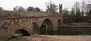
| Ringley Old Bridge Ringley Old Bridge is a stone bridge in Bolton, England, crossing the River Irwell.It has two large semi-circular arches, and a third smaller arch, for the tow path. It is a Grade II structure, listed on 19 August 1986....
|
Stone bridge |
021677 |
StonecloughStoneclough is a suburban area of Kearsley, in the Metropolitan Borough of Bolton, Greater Manchester, England. It is located on the banks of the River Irwell to the southeast of Bolton....
, KearsleyKearsley is a town within the Metropolitan Borough of Bolton, in Greater Manchester, England. Historically within Lancashire, it lies about 7½ miles northwest of Manchester,5.5 miles south-west of Bury, and about 3¾ miles south of Bolton.It is bounded on the west by Walkden, the east by...
53.543697°N 2.357316°W |
The current bridge over the River IrwellThe River Irwell is a long river which flows through the Irwell Valley in the counties of Lancashire and Greater Manchester in North West England. The river's source is at Irwell Springs on Deerplay Moor, approximately north of Bacup, in the parish of Cliviger, Lancashire...
was built in 1677 to replace one washed away in 1673. It is still used today, having been pedestrianised, and is a Grade II* listed building. |
|
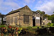
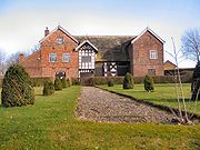
| Smithills Hall Smithills Hall is a Grade I listed manor house, and a Scheduled Monument in the township of Halliwell, now in Bolton, Greater Manchester, England. it stands on the slopes of the moors above Bolton at a height of 500 feet, two miles north west of the town centre. It occupies a defensive site near...
|
Standing building |
0114th century |
BoltonBolton is a town in Greater Manchester, in the North West of England. Close to the West Pennine Moors, it is north west of the city of Manchester. Bolton is surrounded by several smaller towns and villages which together form the Metropolitan Borough of Bolton, of which Bolton is the...
53.602339°N 2.454235°W |
Smithills Hall was originally built in the early 14th century, but was extended in the 15th and 16th centuries. The oldest surviving part is the great hall A great hall is the main room of a royal palace, nobleman's castle or a large manor house in the Middle Ages, and in the country houses of the 16th and early 17th centuries. At that time the word great simply meant big, and had not acquired its modern connotations of excellence...
, which dates from the early 15th century. The site was originally moatA moat is a deep, broad ditch, either dry or filled with water, that surrounds a castle, other building or town, historically to provide it with a preliminary line of defence. In some places moats evolved into more extensive water defences, including natural or artificial lakes, dams and sluices...
ed, however no trace of the moat survives. Smithills Hall is now a Grade I listed building and open to the public as a museum. |
|
Bury
| Name |
Remains |
Date |
Location |
Description |
Ref(s) |
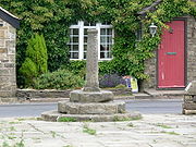
| Affetside Cross |
Stone pillar |
0417th or 18th century |
Affetside Affetside is an upland village located in the West Pennine Moors area, in the Metropolitan Borough of Bury, in Greater Manchester, bordering Bolton in North West England. Historically, it was part of Lancashire. It is also in the Local Council Ward of Tottington, and is situated in the Bury North...
53.618987°N 2.370955°W |
The pillar was originally a cross and replaced a medieval waymarker in the 17th or 18th centuries. The pillar stands on three circular steps, which probably date from 1890 when the cross was taken down for repairs and re-erected. |
|
| Bury Castle Bury Castle is an early medieval moated manor house in Bury, Greater Manchester . It is listed as a Scheduled Ancient Monument. The manor house was built by Sir Thomas Pilkington – lord of the manors of Bury and Pilkington, and an influential member of Lancashire's gentry – in 1469...
|
Below ground remains |
031469 |
BuryBury is a town in Greater Manchester, England. It lies on the River Irwell, east of Bolton, west-southwest of Rochdale, and north-northwest of the city of Manchester...
53.593663°N 2.296994°W |
Bury Castle is a manor house built in 1469, replacing an earlier building on the same site from the late 14th century. It was built by Sir Thomas Pilkington, Lord of the Manor The Lordship of a Manor is recognised today in England and Wales as a form of property and one of three elements of a manor that may exist separately or be combined and may be held in moieties...
s of Bury and Pilkington, and fortified with permission of the king; it was razed to the ground when Sir Thomas had his lands confiscated for supporting the losing side in the War of the Roses. Some of the castle remains have been excavated and are on display to the public. |
|
| Castlesteads Castlesteads is an Iron Age promontory fort, situated on the east bank of the River Irwell on a natural promontory in Bury, Greater Manchester . It is listed as a Scheduled Ancient Monument. Excavated pottery indicates the site was occupied between 200BC and 250AD....
|
Earthworks |
00200 BC–250 AD |
BuryBury is a town in Greater Manchester, England. It lies on the River Irwell, east of Bolton, west-southwest of Rochdale, and north-northwest of the city of Manchester...
53.612875°N 2.306955°W |
Castlesteads is a promontory fort A promontory fort is a defensive structure located above a steep cliff, often only connected to the mainland by a small neck of land, thus utilizing the topography to reduce the ramparts needed. Although their dating is problematic, most seem to date to the Iron Age...
on the banks of the River IrwellThe River Irwell is a long river which flows through the Irwell Valley in the counties of Lancashire and Greater Manchester in North West England. The river's source is at Irwell Springs on Deerplay Moor, approximately north of Bacup, in the parish of Cliviger, Lancashire...
. The site is defended by a 120 m (393.7 ft) long and 6 m (19.7 ft) wide ditch, and a silted up channel of the river. The interior is triangular shaped. Pottery finds indicate the site was occupied from 200 BC to 250 AD. |
|
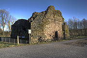
Radcliffe TowerRadcliffe Tower is the only surviving part of a manor house in Radcliffe, Greater Manchester . It is a Grade I listed building and a Scheduled Monument. The house was rebuilt in 1403 by James de Radcliffe, who was lord of the manor of Radcliffe, and consisted of a stone-built hall and one or two...
|
Ruins |
011403 |
RadcliffeRadcliffe is a town within the Metropolitan Borough of Bury, in Greater Manchester, England. It lies on undulating ground in the Irwell Valley, along the course of the River Irwell, south-west of Bury and north-northwest of Manchester. Radcliffe is contiguous with the town of Whitefield to the...
53.56361°N 2.308259°W |
Radcliffe Tower is the only part of a medieval manor houseA manor house is a country house that historically formed the administrative centre of a manor, the lowest unit of territorial organisation in the feudal system in Europe. The term is applied to country houses that belonged to the gentry and other grand stately homes...
that belonged to James de Radliffe, the Lord of the ManorThe Lordship of a Manor is recognised today in England and Wales as a form of property and one of three elements of a manor that may exist separately or be combined and may be held in moieties...
of Radcliffe, still standing. It was a stone-built hall with two towers, and was surrounded by a moat. The site was fortified with the addition of crenellations and battlements with permission from the king. The manor house was demolished in the 19th century. The tower is now a Grade I listed building. |
|
Manchester
| Name |
Remains |
Date |
Location |
Description |
Ref(s) |
Baguley HallBaguley Hall is a 14th century timber framed hall in Baguley, Greater Manchester . It is listed as a Grade I listed building and a Scheduled Ancient Monument....
|
Standing building |
0214th century |
BaguleyBaguley is a locality in Wythenshawe, and an electoral ward of the city of Manchester in North West England.Historically within Cheshire, the town is mentioned as Bagelei in the Domesday Book of 1086.-History:...
53.394955°N 2.276358°W |
The original building was possibly from the 11th or 12th centuries, but the current timber framed house dates from the 14th century. The medieval north wing was refaced in brick. In the 18th century the brick south wing was added. Baguley Hall is considered one of the "finest surviving medieval halls in the northwest of England". It is a Grade I listed building, and is on the Buildings at Risk Register; its condition is rated as "fair" and it is owned by English HeritageEnglish Heritage . is an executive non-departmental public body of the British Government sponsored by the Department for Culture, Media and Sport...
. |
|
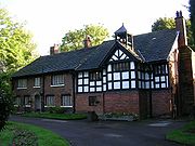
Clayton HallClayton Hall is on Ashton New Road, in Clayton, Manchester, hidden behind trees in a small park. The Hall is a Grade II* listed building, a scheduled ancient monument, and is a rare example of a medieval moated site ....
|
Standing building |
0415th century |
ClaytonClayton is a suburb of the city of Manchester, in North West England. It is situated about 3 miles east of the city centre, on Ashton New Road. Clayton takes its name from the Clayton family who owned large parts of land around the area, including Clayton Vale, through which the River Medlock flows...
53.483419°N 2.178669°W |
The hall, which probably dates back to the 15th century, was probably originally either a quadrangle or consisted of three wings. Much of the hall was demolished in the 17th century and replaced by a new house. Clayton Hall underwent further changes and restoration in the 18th century and in 1900. The hall is on a rectangular island surrounded by a moat and is a Grade II* listed building. |
|
Hanging BridgeHanging Bridge is a medieval bridge spanning the Hanging Ditch, which connected the rivers Irk and Irwell in Manchester, England. The first reference to the bridge was in 1343, when it was called Hengand Brigge, but the present structure was built in 1421, replacing an earlier bridge. Material...
|
Ruins |
051421 |
Cateaton Street, ManchesterManchester is a city and metropolitan borough in Greater Manchester, England. According to the Office for National Statistics, the 2010 mid-year population estimate for Manchester was 498,800. Manchester lies within one of the UK's largest metropolitan areas, the metropolitan county of Greater...
53.484473°N 2.24333°W |
The current structure was built in 1421; however the first reference to the bridge was in 1343. The bridge, which is 33 m (108.3 ft) long and 2.7 m (8.9 ft) wide, spanned Hanging Ditch and was part of medieval Manchester's defences. Hanging Bridge was probably obscured by housing in the 1770s as a result of Manchester's expansion. It was uncovered in 1880s, and again in the late 20th century, and is now on display in Manchester Cathedral's visitor centre. |
|
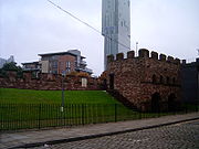
| Mamucium |
Below ground remains |
0079 |
CastlefieldCastlefield is an inner city area of Manchester, in North West England. The conservation area which bears its name is bounded by the River Irwell, Quay Street, Deansgate and the Chester Road. It was the site of the Roman era fort of Mamucium or Mancunium which gave its name to Manchester...
, ManchesterManchester is a city and metropolitan borough in Greater Manchester, England. According to the Office for National Statistics, the 2010 mid-year population estimate for Manchester was 498,800. Manchester lies within one of the UK's largest metropolitan areas, the metropolitan county of Greater...
53.474744°N 2.253219°W |
A Roman fortThe Latin word castra, with its singular castrum, was used by the ancient Romans to mean buildings or plots of land reserved to or constructed for use as a military defensive position. The word appears in both Oscan and Umbrian as well as in Latin. It may have descended from Indo-European to Italic...
was established on a sandstone bluff near a crossing over the River MedlockThe River Medlock is a river of Greater Manchester in North West England. It rises near Oldham and flows, south and west, for ten miles to join the River Irwell in the extreme southwest of Manchester city centre.-Source:...
, along the line of the Roman roadThe Roman roads were a vital part of the development of the Roman state, from about 500 BC through the expansion during the Roman Republic and the Roman Empire. Roman roads enabled the Romans to move armies and trade goods and to communicate. The Roman road system spanned more than 400,000 km...
between ChesterChester is a city in Cheshire, England. Lying on the River Dee, close to the border with Wales, it is home to 77,040 inhabitants, and is the largest and most populous settlement of the wider unitary authority area of Cheshire West and Chester, which had a population of 328,100 according to the...
(Deva VictrixDeva Victrix, or simply Deva, was a legionary fortress and town in the Roman province of Britannia. The settlement evolved into Chester, the county town of Cheshire, England...
) and YorkYork is a walled city, situated at the confluence of the Rivers Ouse and Foss in North Yorkshire, England. The city has a rich heritage and has provided the backdrop to major political events throughout much of its two millennia of existence...
(EboracumEboracum was a fort and city in Roman Britain. The settlement evolved into York, located in North Yorkshire, England.-Etymology:The first known recorded mention of Eboracum by name is dated circa 95-104 AD and is an address containing the Latin form of the settlement's name, "Eburaci", on a wooden...
); it was designed to garrison a cohortA cohort was the basic tactical unit of a Roman legion following the reforms of Gaius Marius in 107 BC.-Legionary cohort:...
of 500 auxiliaryAuxiliaries formed the standing non-citizen corps of the Roman army of the Principate , alongside the citizen legions...
soldiers. A civilian settlement (vicusIn ancient Rome, the vicus was a neighborhood. During the Republican era, the four regiones of the city of Rome were subdivided into vici. In the 1st century BC, Augustus reorganized the city for administrative purposes into 14 regions, comprising 265 vici. Each vicus had its own board of...
) of traders and families grew up around the fort. In around 140, the fort was demolished and the civilian settlement was abandoned around the same time. The fort was rebuilt in 160 and the settlement was re-inhabited. It was abandoned by the mid-3rd century, although the fort was in use into the early 4th century. A partial reconstruction of the fort on the site is open to the public. |
|
| Nico Ditch Nico Ditch is a six mile long linear earthwork running between Ashton-under-Lyne and Stretford in Greater Manchester, England. It may have been dug as a defensive fortification, but more likely it was intended to be a boundary marker...
|
Earthwork |
017th–9th centuries |
Ashton-under-Lyne Ashton-under-Lyne is a market town in the Metropolitan Borough of Tameside, Greater Manchester, England. Historically a part of Lancashire, it lies on the north bank of the River Tame, on undulating land at the foothills of the Pennines...
and DentonDenton is a town within the Metropolitan Borough of Tameside, in Greater Manchester, England. It is five miles to the east of Manchester city centre, and has a population of 26,866....
53.453083°N 2.399854°W |
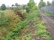
Nico Ditch is an earthwork stretching from Ashton Moss in the east to Hough Moss in the west. According to legend, the ditch was dug in a single night as a defence against Viking invaders in 869–870. However, the U-shaped profile of the ditch indicates it was not defensive as it would most likely be V-shaped. It was probably used as an administrative boundary. The ditch is visible in sections, and in places is about 1.5 m (4.9 ft) deep and up to 4 m (13.1 ft) wide. |
|
| Peel Hall |
Waterlogged moat |
0314th century |
Ashton New Road, ManchesterManchester is a city and metropolitan borough in Greater Manchester, England. According to the Office for National Statistics, the 2010 mid-year population estimate for Manchester was 498,800. Manchester lies within one of the UK's largest metropolitan areas, the metropolitan county of Greater...
53.377989°N 2.244301°W |
In the mid 14th century, Sir John de Arderne built Peel Hall. The site is surrounded by a moat which is between 8 and 14 m (26.2 and 45.9 ft) wide and 1.2 m (3.9 ft) deep. Peel Hall was demolished in 1809 and replaced by a farmhouse on the same site, which was demolished in 1975. |
|
Oldham
| Name |
Remains |
Date |
Location |
Description |
Ref(s) |
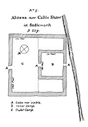
Castleshaw Roman fortCastleshaw Roman fort was a fort in the Roman province of Britannia. Although there is no evidence to substantiate the claim, it has been suggested that Castleshaw Roman fort is the site of Rigodunum, a Brigantian settlement. The remains of the fort are located on Castle Hill on the eastern side of...
|
Below ground remains |
0179 |
Castleshaw Castleshaw is a hamlet in the Saddleworth parish of the Metropolitan Borough of Oldham in Greater Manchester, England. It lies amid the Pennines, north of Uppermill, west-southwest of Marsden, and east-northeast of Oldham....
, SaddleworthSaddleworth is a civil parish of the Metropolitan Borough of Oldham in Greater Manchester, England. It comprises several villages and hamlets amongst the west side of the Pennine hills: Uppermill, Greenfield, Dobcross, Delph, Diggle and others...
53.583244°N 2.001737°W |
In 79, a fortThe Latin word castra, with its singular castrum, was used by the ancient Romans to mean buildings or plots of land reserved to or constructed for use as a military defensive position. The word appears in both Oscan and Umbrian as well as in Latin. It may have descended from Indo-European to Italic...
was established at Castleshaw by the Romans, for a garrison of 500 auxiliary soldiers, as part of the frontier defences along the road between Chester (Deva Victrix) and York (Eboracum). It was slightedA slighting is the deliberate destruction, partial or complete, of a fortification without opposition. During the English Civil War this was to render it unusable as a fort.-Middle Ages:...
in 90, but a smaller fort – or fortlet – was built on the site in 105, designed for a garrison of less than 100. A civilian settlement (vicus), made up of traders and hangers on of the soldiers, grew around the fort in the 2nd century. The fortlet was abandoned in the mid 120s when it was superseded by the neighbouring forts at Manchester and Slack. About the same time, the civilian settlement was abandoned. A series of ditches and earthworks was built to mark the site. |
|
| Saddleworth Bowl Barrow |
Earthworks |
00Bronze Age The Bronze Age is a period characterized by the use of copper and its alloy bronze as the chief hard materials in the manufacture of some implements and weapons. Chronologically, it stands between the Stone Age and Iron Age...
|
SaddleworthSaddleworth is a civil parish of the Metropolitan Borough of Oldham in Greater Manchester, England. It comprises several villages and hamlets amongst the west side of the Pennine hills: Uppermill, Greenfield, Dobcross, Delph, Diggle and others...
53.563554°N 2.029973°W |
The barrow is oval shaped and measures 17 m (18.6 yd) by 18 m (19.7 yd) and is 0.5 m (1.6 ft) high. The barrow has been excavated archaeologically, but has not revealed any signs of grave good or human remains. The site is in good condition. |
|
Salford
| Name |
Remains |
Date |
Location |
Description |
Ref(s) |
| Iron Age promontory fort |
Below ground remains |
00500BC–200AD |
SalfordThe City of Salford is a city and metropolitan borough of Greater Manchester, England. It is named after its largest settlement, Salford, but covers a far larger area which includes the towns of Eccles, Swinton-Pendlebury, Walkden and Irlam which apart from Irlam each have a population of over...
53.437609°N 2.465123°W |
The promontory fort A promontory fort is a defensive structure located above a steep cliff, often only connected to the mainland by a small neck of land, thus utilizing the topography to reduce the ramparts needed. Although their dating is problematic, most seem to date to the Iron Age...
is surrounded by two ditches. Inside the fort are four circular structures that are probably industrial areas and livestock enclosures. The Cheshire Very Coarse Pottery (VCP) found on the site is the only evidence of a late prehistoric pottery industry in Greater Manchester. |
|
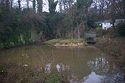
| Worsley Delph |
Brick structure |
011759 |
SwintonSwinton is a town within the City of Salford, in Greater Manchester, England. Located on the A6 road it stands on gently sloping ground on the southwest side of the River Irwell, and within the bounds of the orbital M60 motorway. It is west-northwest of Salford, and west-northwest of Manchester...
53.500795°N 2.379195°W |
In 1759, construction began on a system of underground canals; they provided a route between Worsley Colliery and the Bridgewater CanalThe Bridgewater Canal connects Runcorn, Manchester and Leigh, in North West England. It was commissioned by Francis Egerton, 3rd Duke of Bridgewater, to transport coal from his mines in Worsley to Manchester...
for the coal the colliery produced. The canals were used for this purpose until 1887 and closed shortly after the last coal pit in the area in 1968. |
|
Stockport
| Name |
Remains |
Date |
Location |
Description |
Ref(s) |
| Brown Low Brown Low is a bowl barrow most likely dating to the Bronze Age. An earth and stone mound survives east of Marple, Greater Manchester . It is listed as a Scheduled Ancient Monument. Excavations have discovered fragments of burnt stones and cremated bones. It is located in private land, just to one...
|
Earthworks |
00Bronze Age The Bronze Age is a period characterized by the use of copper and its alloy bronze as the chief hard materials in the manufacture of some implements and weapons. Chronologically, it stands between the Stone Age and Iron Age...
|
Ludworth Ludworth is an area of Marple, Greater Manchester in Greater Manchester. Ludworth Civil Parish was created in 1896; it was part of Glossop Dale Rural District until 1934 when it was transferred to Chapel-en-le-Frith Rural District. In 1936 it was transferred, along with Mellor to Marple Urban...
, Hazel Grove-Education:Hazel Grove has a number of primary schools and Hazel Grove High School, the local high school. Some do decide to go to other local high schools, such as local Marple Hall, in neighbouring village Marple. The main primary schools in the area are, Hazel Grove Primary School, Torkington...
53.414871°N 2.01768°W |
Brown Low is a bowl barrowBowl Barrow is the name for a type of burial mound or tumulus. A barrow is a mound of earth used to cover a tomb. The bowl barrow gets its name from the fact that it looks like an upturned bowl...
, 25.5 m (83.7 ft) in diameter and 2 m (6.6 ft) high. The site is covered in turf, and two hollows on the barrow are from an 1809 excavation. |
|
| Cairn |
Mound of stones |
01Bronze Age The Bronze Age is a period characterized by the use of copper and its alloy bronze as the chief hard materials in the manufacture of some implements and weapons. Chronologically, it stands between the Stone Age and Iron Age...
|
Ludworth Ludworth is an area of Marple, Greater Manchester in Greater Manchester. Ludworth Civil Parish was created in 1896; it was part of Glossop Dale Rural District until 1934 when it was transferred to Chapel-en-le-Frith Rural District. In 1936 it was transferred, along with Mellor to Marple Urban...
, Hazel Grove-Education:Hazel Grove has a number of primary schools and Hazel Grove High School, the local high school. Some do decide to go to other local high schools, such as local Marple Hall, in neighbouring village Marple. The main primary schools in the area are, Hazel Grove Primary School, Torkington...
53.381878°N 2.020223°W |
The late Bronze Age cairn is 12 m (39.4 ft) in diameter and 0.4 m (1.3 ft) high. There is a series of chambers and cremation cists. Due to its position on a knoll on Mellor Moor, it is highly visible. |
|
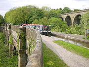
Marple AqueductMarple Aqueduct, also known as the Grand Aqueduct, carries the lower level of the Peak Forest Canal across the River Goyt at Marple, Greater Manchester, in north-west England....
|
AqueductAn aqueduct is a water supply or navigable channel constructed to convey water. In modern engineering, the term is used for any system of pipes, ditches, canals, tunnels, and other structures used for this purpose....
|
051801 The year 1801 in architecture involved some significant events.-Births:* May 11 - Henri Labrouste * June 4 - James Pennethorne...
|
MarpleMarple is a small town within the Metropolitan Borough of Stockport, in Greater Manchester, England. It lies on the River Goyt southeast of Stockport.Historically part of Cheshire, Marple has a population of 23,480 .-Toponymy:...
53.407032°N 2.067323°W |
The Marple Aqueduct was built between 1794 and 1801 to carry the Peak Forest CanalThe Peak Forest Canal, is a narrow locked artificial waterway in northern England. It is long and forms part of the connected English/Welsh inland waterway network.-General description:...
over the River Goyt. The aqueduct is still in use for pleasure craft. |
|
| Oldknows Limekilns |
Lime kilns |
041797 |
MarpleMarple is a small town within the Metropolitan Borough of Stockport, in Greater Manchester, England. It lies on the River Goyt southeast of Stockport.Historically part of Cheshire, Marple has a population of 23,480 .-Toponymy:...
53.392655°N 2.05572°W |
Between 1797 and 1800, Samuel Oldknow built three lime kilns on the east side of the Peak Forest CanalThe Peak Forest Canal, is a narrow locked artificial waterway in northern England. It is long and forms part of the connected English/Welsh inland waterway network.-General description:...
. The kilns are 11 m (36.1 ft) deep and were built into the hillside. The site operated into the 20th century, and the remaining walling of the kilns is protected as a Grade II listed building. |
|
| Peel Moat |
Dry moat |
02Medieval |
Heaton MoorHeaton Moor is a suburb located in Stockport, Greater Manchester, in North West England. It is one of the Four Heatons and borders onto Heaton Chapel, Heaton Norris and Heaton Mersey...
, StockportStockport is a town in Greater Manchester, England. It lies on elevated ground southeast of Manchester city centre, at the point where the rivers Goyt and Tame join and create the River Mersey. Stockport is the largest settlement in the metropolitan borough of the same name...
53.428747°N 2.188373°W |
The dried-up, rectangular moat surrounds the site of a square-shaped fortified tower. There are no above ground remains of the tower, but it was situated on an area of land 29 m (95.1 ft) square, with the surrounding moat measuring between 5.5 m (18 ft) and 10 m (32.8 ft) wide. |
|
| Torkington Moat |
Water-logged moat |
03Medieval |
Torkington Torkington is a place in Greater Manchester, England. It forms part of the Metropolitan Borough of Stockport-History:In 1875 Torkington was one of eight civil parishes of Cheshire to be included in the Stockport rural sanitary district...
, StockportThe Metropolitan Borough of Stockport is a metropolitan borough of Greater Manchester, in north west England, centred around the town of Stockport. It has a population of about 280,600 and includes the outyling areas of Cheadle and Cheadle Hulme, Marple, Bredbury, Reddish and Romiley...
53.384902°N 2.091045°W |
The moat in Torkington surrounds the site of the manor house that was first built in 1350. The 1.6 m (5.2 ft) deep moat is between 8 and 20 m (26.2 and 65.6 ft) wide, and forms the perimeter of a 46 m (150.9 ft) by 43 m (141.1 ft) island. Torkington Hall replaced the medieval manor house in the early 17th century. |
|
Tameside
| Name |
Remains |
Date |
Location |
Description |
Ref(s) |
Buckton CastleBuckton Castle is a medieval ringwork near Carrbrook, Stalybridge, England. It is listed as a Scheduled Ancient Monument due to its proximity to the Buckton Vale Quarry. The castle is oval, with a stone curtain wall wide, surrounded by a ditch wide and deep. Buckton Castle was probably...
|
Below ground remains |
011180s |
CarrbrookCarrbrook is an area in the east of Stalybridge, in Greater Manchester, England. The area still has many seventeenth and eighteenth century buildings. Much of the late-nineteenth and early-twentieth century village was built during the industrial boom brought by the printworks. Modern Housing...
53.511059°N 2.016212°W |
Buckton Castle is a ringwork A ringwork is a form of fortified defensive structure, usually circular or oval in shape. Ringworks are essentially motte-and-bailey castles minus the motte...
castle and was built in the late 12th century for William de Neville. It may have been constructed to guard the Longdendale ValleyLongdendale is a valley in the north of England, north of Glossop and south east of Holmfirth. The name means "long wooded valley".- Geography :...
. The castle was first referred to in 1360, when it was in a ruinous state. The castle is circular, measuring 35 m (114.8 ft) and 45 m (147.6 ft) along the axes, and is surrounded by a 10 m (32.8 ft) wide and 6 m (19.7 ft) deep ditch. Buckton Castle has been damaged by 18th century treasure hunters and later 19th and 20th century quarrying. |
|
| Cairn |
Mound of stones |
00Bronze Age The Bronze Age is a period characterized by the use of copper and its alloy bronze as the chief hard materials in the manufacture of some implements and weapons. Chronologically, it stands between the Stone Age and Iron Age...
|
Stalybridge Stalybridge is a town in the Metropolitan Borough of Tameside in Greater Manchester, England, with a population of 22,568. Historically a part of Cheshire, it is east of Manchester city centre and northwest of Glossop. With the construction of a cotton mill in 1776, Stalybridge became one of...
53.478768°N 2.018419°W |
The turf covered round cairn is situated on top of a hill, and consists of a mound of stones with a flat top. It is 1 m (3.3 ft) high and 16 m (52.5 ft) in diameter, although the southern edge has been destroyed. The site has been altered in modern period by the addition of a dry stone Dry stone is a building method by which structures are constructed from stones without any mortar to bind them together. Dry stone structures are stable because of their unique construction method, which is characterized by the presence of a load-bearing facade of carefully selected interlocking...
wall and a trigonometrical pillarA triangulation station, also known as a triangulation pillar, trigonometrical station, trigonometrical point, trig station, trig beacon or trig point, and sometimes informally as a trig, is a fixed surveying station, used in geodetic surveying and other surveying projects in its vicinity...
. |
|
Trafford
| Name |
Remains |
Date |
Location |
Description |
Ref(s) |
| Watch Hill Castle Watch Hill Castle is an early medieval motte-and-bailey on the border of Bowdon and Dunham Massey, England. It is the only Scheduled Ancient Monument in Trafford, and so is arguably the most important archaeological site in the borough...
|
Earthworks |
Probable 12th century |
Bowdon Bowdon is a suburban village and electoral ward in the Altrincham area of the Metropolitan Borough of Trafford, in Greater Manchester, England.-History:...
53.369862°N 2.378858°W |
The castle is a motte-and-bailey A motte-and-bailey is a form of castle, with a wooden or stone keep situated on a raised earthwork called a motte, accompanied by an enclosed courtyard, or bailey, surrounded by a protective ditch and palisade...
, consisting of a conical mound (motte) 40 m (131.2 ft) in diameter and 17 m (55.8 ft) high, surrounded by a triangular lower enclosure (bailey) covering 2400 square metre (0.593052391236663 acre). It probably belonged to Hamon de MasseyThe first Hamon de Massey was the owner of the manors of Agden, Baguley, Bowdon, Dunham, Hale and Little Bollington after the Norman conquest of England in 1066, taking over from the Saxon thegn Aelfward according to the Domesday Book....
, a baron who owned several manorsManorialism, an essential element of feudal society, was the organizing principle of rural economy that originated in the villa system of the Late Roman Empire, was widely practiced in medieval western and parts of central Europe, and was slowly replaced by the advent of a money-based market...
locally, inlcluding those of BaguleyBaguley is a locality in Wythenshawe, and an electoral ward of the city of Manchester in North West England.Historically within Cheshire, the town is mentioned as Bagelei in the Domesday Book of 1086.-History:...
, BowdonBowdon is a suburban village and electoral ward in the Altrincham area of the Metropolitan Borough of Trafford, in Greater Manchester, England.-History:...
, DunhamDunham Massey is a civil parish in the Metropolitan Borough of Trafford, Greater Manchester, England. The parish includes the villages of Sinderland Green, Dunham Woodhouse and Dunham Town, along with Dunham Massey Park, formerly the home of the last Earl of Stamford and owned by the National Trust...
, and HaleHale is a village and electoral ward within the Metropolitan Borough of Trafford, in Greater Manchester, England. It is contiguous with the southeast of Altrincham, approximately southwest of the city of Manchester....
. The structure had fallen into disuse by the 13th century. |
|
Wigan
| Name |
Remains |
Date |
Location |
Description |
Ref(s) |
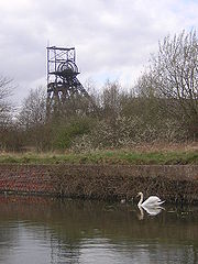
| Astley Green Colliery The Astley Green Colliery Museum is a museum run by the Red Rose Steam Society in Astley near Tyldesley in Greater Manchester, England. Before becoming a museum, the site was a working colliery that produced coal from 1912 to 1970; it is now protected as a Scheduled Monument...
|
Mining site |
k1908 |
Astley Astley is a settlement within the Metropolitan Borough of Wigan in Greater Manchester, England, variously described as a suburb or a village. Astley lies on flat land to the northwest of the city of Manchester, and is crossed by the Bridgewater Canal and the A580 "East Lancashire Road"...
53.495311°N 2.444649°W |
The Pilkington Colliery Company began construction of the colliery in 1908, and the site opened for coal production in 1912. The colliery was closed in 1970 and is now Astley Green Colliery Museum The Astley Green Colliery Museum is a museum run by the Red Rose Steam Society in Astley near Tyldesley in Greater Manchester, England. Before becoming a museum, the site was a working colliery that produced coal from 1912 to 1970; it is now protected as a Scheduled Monument...
. Most of the buildings associated with the colliery have been destroyed as has one of the mine shafts. |
|
| Cross base |
Cross base |
aMedieval |
Junction of Green Lane, Standish Wood Lane and Beech Walk, Standish Standish is a village within the Metropolitan Borough of Wigan, in Greater Manchester, England. It is located on the A49 road between the towns of Chorley and Wigan, a short distance from Junction 27 of the M6 motorway....
53.580335°N 2.662006°W |
The stone cross was one of four known crosses that marked the medieval route from Wigan to ChorleyChorley is a market town in Lancashire, in North West England. It is the largest settlement in the Borough of Chorley. The town's wealth came principally from the cotton industry...
. The cross base is no longer in its original place, having been moved when the road was widened. |
|
| Cross base |
Cross base |
bMedieval |
Green Lane, Standish Standish is a village within the Metropolitan Borough of Wigan, in Greater Manchester, England. It is located on the A49 road between the towns of Chorley and Wigan, a short distance from Junction 27 of the M6 motorway....
53.581062°N 2.660506°W |
The stone cross was one of four known crosses that marked the medieval route from Wigan to Chorley. It is protected as a Grade II listed building. |
|
| Cross base |
Cross base |
cMedieval |
Standish Wood Lane, Standish Standish is a village within the Metropolitan Borough of Wigan, in Greater Manchester, England. It is located on the A49 road between the towns of Chorley and Wigan, a short distance from Junction 27 of the M6 motorway....
53.573511°N 2.66054°W |
The stone cross was one of four known crosses that marked the medieval route from Wigan to Chorley. |
|
| Gidlow Hall Gidlow Hall is a scheduled ancient monument dating from 1574 in Aspull village, in Wigan, Greater Manchester. The great hall was the residence of the Gidlow family, whose members included Robert de Gidlow, freeholder of Aspull in 1291. Members of the family were recorded in the village until the...
|
Standing building |
h1574 |
Aspull 53.558532°N 2.566397°W |
The present structure dates from around 1574, although it is thought to have replaced an earlier building. In 1840, the hall was rebuilt in the Gothic Revival styleThe Gothic Revival is an architectural movement that began in the 1740s in England...
. Gidlow Hall is protected as a Grade II listed building. |
|
| The Great Haigh Sough The Great Haigh Sough is a tunnel or adit driven under Sir Roger Bradshaigh's estate in Haigh, then in the historic county of Lancashire. Coal had been dug on the estate since Tudor times. The sough drained Bradshaigh's coal pits, which produced coal and cannel, and extended the life of the shallow...
Portal |
Brick drainage |
i1653 |
HaighHaigh is a village and civil parish of the Metropolitan Borough of Wigan in Greater Manchester, England. Historically a part of Lancashire, it is located next to the village of Aspull. The western boundary is the River Douglas which separates the township from Wigan. To the north a small brook...
53.559088°N 2.617436°W |
Between 1653 and 1670, the Haigh Sough drainage system was under construction; its purpose was to drain to drain the local collieries. The system extends for 936 m (3,070.9 ft) and has only one entrance. It was in use until 1929 and the entrance is now covered by a steel grille to prevent access. |
|
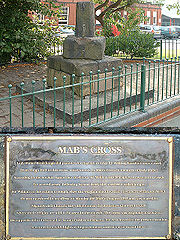
Mab's CrossMab's Cross, in Wigan, Greater Manchester, is a stone cross probably dating from the 13th century . The remains of the cross are a one metre square dressed gritstone block high on top of a stone plinth and are protected as a Scheduled Ancient Monument and a Grade II* listed building...
|
Stub of stone cross |
f13th century |
Standishgate, Wigan Wigan is a town in Greater Manchester, England. It stands on the River Douglas, south-west of Bolton, north of Warrington and west-northwest of Manchester. Wigan is the largest settlement in the Metropolitan Borough of Wigan and is its administrative centre. The town of Wigan had a total...
53.551132°N 2.626076°W |
Mab's Cross was one of four known crosses that marked the medieval route from Wigan to Chorley. In 1922, the cross was moved from its original position when the road was widened and is protected as a Grade II* listed building. |
|
| Standish Market Cross |
Stone cross |
dMedieval |
Market place, Standish Standish is a village within the Metropolitan Borough of Wigan, in Greater Manchester, England. It is located on the A49 road between the towns of Chorley and Wigan, a short distance from Junction 27 of the M6 motorway....
53.586545°N 2.660592°W |
The base of the stone cross is medieval, but the cross shaft is modern. It is protected as a Grade II listed building. |
|
| Moat of Moat House |
Dried-up moat |
j18th century |
HaighHaigh is a village and civil parish of the Metropolitan Borough of Wigan in Greater Manchester, England. Historically a part of Lancashire, it is located next to the village of Aspull. The western boundary is the River Douglas which separates the township from Wigan. To the north a small brook...
53.576598°N 2.603644°W |
All that remains is a dried-up square moat surrounding the 18th-century Moat House. |
|
| Morleys Hall Morleys Hall, a moated hall converted to two houses, is situated at on Morleys Lane, on the edge of Astley Moss in Astley, Greater Manchester, England. It was largely rebuilt in the 19th century on the site of a medieval timber house. The hall is a Grade II* listed building and the moat a...
|
Standing building |
eMedieval |
Astley Astley is a settlement within the Metropolitan Borough of Wigan in Greater Manchester, England, variously described as a suburb or a village. Astley lies on flat land to the northwest of the city of Manchester, and is crossed by the Bridgewater Canal and the A580 "East Lancashire Road"...
53.489019°N 2.467796°W |
The current hall was built in the 19th century, however some 16th and 17th century timber framingTimber framing , or half-timbering, also called in North America "post-and-beam" construction, is the method of creating structures using heavy squared off and carefully fitted and joined timbers with joints secured by large wooden pegs . It is commonplace in large barns...
is incorporated into the structure. In 1641, it was the home of Ambrose BarlowAmbrose Edward Barlow, O.S.B., was an English Benedictine monk who is venerated as a saint in the Catholic Church. He is one of a group of saints canonized by Pope Paul VI who became known as the Forty Martyrs of England and Wales....
. The site is surrounded by a 12–15 m (39.4–49.2 ft) wide and 3 m (9.8 ft) deep waterlogged medieval moat, and Morleys Hall is a Grade II* listed building. |
|
| New Hall |
Moat |
g16th century |
Astley Astley is a settlement within the Metropolitan Borough of Wigan in Greater Manchester, England, variously described as a suburb or a village. Astley lies on flat land to the northwest of the city of Manchester, and is crossed by the Bridgewater Canal and the A580 "East Lancashire Road"...
, TyldesleyTyldesley is a town within the Metropolitan Borough of Wigan, in Greater Manchester, England. It occupies an area north of Chat Moss near the foothills of the West Pennine Moors, east-southeast of Wigan and west-northwest of the city of Manchester...
53.505706°N 2.453352°W |
The moat surrounds the site of the original medieval building, which was replaced a by a post-medieval farmhouse. The moat is filled with water, however the ruined farmhouse is not part of the Scheduled Monument. |
|
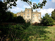
Winstanley HallWinstanley Hall is a late 16th century house in Winstanley, in the Metropolitan Borough of Wigan . It is listed as a Scheduled Ancient Monument and a Grade II* listed building...
|
Standing building |
h1560s -Buildings:* 1560 - Construction of Mexico City Cathedral, begins.* 1561 - Postnik Yakovlev complete the Saint Basil's Cathedral, Moscow.* 1563 - Construction of El Escorial , designed by Juan de Herrera, begins....
|
WinstanleyWinstanley is a area of the Metropolitan Borough of Wigan, in Greater Manchester, England. The area serves primarily as a residential suburb, and has a total population of 15,849.-Transport:...
53.522389°N 2.68735°W |
Winstanley hall was built in the 1560s for the Winstanley family of Wigan, who were Lords of the Manor. It is linked with the neighbouring halls of Bispham Hall (built in 1573), Birchley Hall (1594), and Hacking Hall (1607). Winstanley Hall was extended in the 17th and 18th centuries, and further work was done in the 19th century including work by architect Lewis Wyatt Lewis William Wyatt was a British architect, a nephew of both Samuel and James Wyatt of the Wyatt family of architects, who articled with each of his uncles and began practice on his own about 1805....
in the Jacobean styleThe Jacobean style is the second phase of Renaissance architecture in England, following the Elizabethan style. It is named after King James I of England, with whose reign it is associated.-Characteristics:...
. The building is currently in a decayed state, and lies unoccupied. It is also a Grade II* listed building. |
|
|
|