

River Etherow
Encyclopedia
The River Etherow is a river
in northern England
, and a tributary
of the River Goyt. Although now passing through South Yorkshire
, Derbyshire
and Greater Manchester
, it historically formed the ancient county boundary between Cheshire
and Derbyshire. The upper valley is known as Longdendale
. The river has a watershed of approximately 30 square miles (77.7 km²), and the area an annual rainfall of 52.5 inches (1,333.5 mm).
 Rising at Featherbed Moss in the Sheffield
district of South Yorkshire, the river broadens into the Longdendale Chain
of reservoirs in the Peak District National Park
. It emerges again in Tintwistle
, Derbyshire, at the foot of Bottoms Reservoir
dam
and passes Melandra Castle
in Gamesley
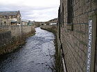
, where it is joined by Glossop Brook. The Etherow enters the borough of Tameside
at Hollingworth
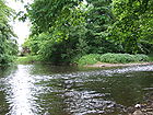
in Greater Manchester, passing into Stockport where it passes through Etherow Country Park
. It flows into the River Goyt at Brabyns Park near Marple
. The River Tame
joins the Goyt 4 miles (6 km) downstream, forming the River Mersey
.
 The upper reaches of the River Etherow pass through peat
moorland
, inhabited by Fox
es, Vole
s and an introduced population of Mountain Hare
. Red Grouse
, Ring Ouzel
, Wheatear
and Golden Plover
may be seen. Kestrel
s, Merlin
s and Short-eared Owl
s nest here. The reservoirs attract Mallard
s, and also Teal
, Pochard
, Common Sandpiper
s, Black-headed Gull
s and Canada Geese. The woodlands are home to Redstart
, Great Spotted Woodpecker
, and Spotted Flycatcher
. Water Rail
have been recorded at Etherow Country Park.
 Longdendale is a steep-sided V-shaped valley that is glacial
in origin. Longdendale is in the Dark Peak
, where a thick blanket of peat overlies the Millstone Grit
sandstone, formed on a bed of shale
through which flows the Etherow. Directly beneath the upper valley lie areas of Carboniferous
Millstone Grit, shales and sandstone
. It is on the edge of the Peak District
Dome, at the southern edge of the Pennine anticline
. The Variscan uplift
has caused much faulting and Glossopdale was the product of glacial action in the last glaciation period that exploited the weakened rocks. The steep-sided valleys of the clough
s cause significant erosion
and deposition. The layers of sandstone, mudstones and shale in the bedrock act as an aquifer
to feed the springs. The valley bottoms have a thin deposit of boulder clay
. The brooks are fed by the peaty soils of the moors and are, therefore, acid
ic (pH5.5–7.0).
under Agricola
built the fort of Ardotalia
(later known as Melandra or Melandra Castle) to defend it. The Mercians settled at Hollingworth about 650AD. Many placenames of the area date from this period; for example, Mottram
and Glossop
. By 1086 the river was firmly established as the boundary between Cheshire and Derbyshire.
 A packhorse
route (known as a saltway) was maintained from the Middle Ages
onwards to allow the export of salt from the Cheshire towns of Nantwich
, Northwich
and Middlewich
across the Pennines
. The saltway followed the Etherow to Ladyshaw, and at Salters Brook it forked, with one route leading to Wakefield
and another to Barnsley
.
Water was an important source of power for industry, and the Etherow and its tributaries were fast flowing and constant. Watermill
s were used to grind meal
and to full
woollen cloth (Littlemoor 1781). Wool was transported along the turnpike
road (1731) that ran from Ashton-under-Lyne
, Stalybridge
, Mottram, Woodhead
and Lady's Cross to Sheffield
, to be woven
on hand-looms in the dale.
From 1782 to 1820, water-powered cotton mill
s were built along many brooks feeding the Etherow, including six on the Glossop side of the river. With the adoption of steam to power the ever-larger mills, built closer to the coal fields, the river assumed a new role as a source of water for Manchester
and Salford. In 1844 John Frederick Bateman
advised Manchester Corporation that the River Etherow, which rose at the highest point of the Pennine chain, could provide water, collected in purpose-built reservoirs, "nearly as pure as if it comes from the heavens." This led to the construction of the Longdendale Chain
of reservoirs, the first scheme of its type in the world. Three reservoirs were built on the Etherow to impound drinking water, with another two to provide compensation water for the mills downstream.
, Torside Reservoir
and Rhodeswood Reservoir
, supplying 24000000 gallons (109.1 Ml) of water a day by gravity to Manchester and Salford, and 6600000 gallons (30 Ml) to Hyde
and Denton
through the Mottram tunnel
. Valehouse Reservoir
and Bottoms Reservoir are compensating reservoirs which have a combined holding capacity of 4200000000 gallons (19,093.6 Ml).
to the Woodhead Tunnel
portal, was an important cross-Pennine route built in 1844 by the Sheffield, Ashton-under-Lyne and Manchester Railway
. Three tunnels
of 4840 metres (15,879.3 ft) were dug, connecting Woodhead with Dunford Bridge
on the River Don. Though now closed to railway traffic, one tunnel is used to route electricity cables for the National Grid, with work in progress to use a second tunnel for a new cable, thus preventing the re-establishment of rail traffic.
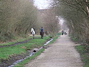 Following the closure of the railway line, the trackbed was taken up and the Longdendale Trail
constructed along its route. This is now part of the Trans-Pennine Trail, Sustrans
National Cycle Route 62. This, in its turn, is part of the 2000 miles (3,218.7 km) European walking route E8
from Liverpool to Istanbul. The Pennine Way
crosses Longdendale, descending from Bleaklow
to the south and ascending Black Hill
to the north. The youth hostel
at Crowden is a traditional stop after the first day's walking, from Edale
.
The circular walk known as 'The Longdendale Edges' takes in the high ground (at about the 1000 feet (304.8 m)-1500 feet (457.2 m) level) on both sides of the valley. It is about 17 miles (27.4 km) long and is 'not recommended in doubtful weather'. The detailed route, clockwise from Crowden Youth Hostel, is given in Peak District Walking Guide No.2, published by the Peak Park Planning Board.
which is situated in Compstall
, close to the mouth of the Etherow, opened in 1968 as one of the UK's first country park
s. Originally it was an industrial area incorporating a mine, a mill and a mill pond. The River Etherow flows through the park and is the source for the mill pond. Etherow Country Park has many local groups associated with it including a small local community group, the Friends of Etherow, anglers, the afore-mentioned sailing club, and a model boat club.
Compstall Nature Reserve is a 12.8 hectare (31.6 acre) region of the park which is designated a Site of Special Scientific Interest (SSSI). The area was given the designation in 1977 for its biological interest, in particular its wide range of habitats, including open water, tall fen
, reed swamp
, carr
and mixed deciduous
woodland
.
, Bleaklow
and Black Hill
. Minor left tributaries are:
Minor right tributaries are:
River
A river is a natural watercourse, usually freshwater, flowing towards an ocean, a lake, a sea, or another river. In a few cases, a river simply flows into the ground or dries up completely before reaching another body of water. Small rivers may also be called by several other names, including...
in northern England
Northern England
Northern England, also known as the North of England, the North or the North Country, is a cultural region of England. It is not an official government region, but rather an informal amalgamation of counties. The southern extent of the region is roughly the River Trent, while the North is bordered...
, and a tributary
Tributary
A tributary or affluent is a stream or river that flows into a main stem river or a lake. A tributary does not flow directly into a sea or ocean...
of the River Goyt. Although now passing through South Yorkshire
South Yorkshire
South Yorkshire is a metropolitan county in the Yorkshire and the Humber region of England. It has a population of 1.29 million. It consists of four metropolitan boroughs: Barnsley, Doncaster, Rotherham, and City of Sheffield...
, Derbyshire
Derbyshire
Derbyshire is a county in the East Midlands of England. A substantial portion of the Peak District National Park lies within Derbyshire. The northern part of Derbyshire overlaps with the Pennines, a famous chain of hills and mountains. The county contains within its boundary of approx...
and Greater Manchester
Greater Manchester
Greater Manchester is a metropolitan county in North West England, with a population of 2.6 million. It encompasses one of the largest metropolitan areas in the United Kingdom and comprises ten metropolitan boroughs: Bolton, Bury, Oldham, Rochdale, Stockport, Tameside, Trafford, Wigan, and the...
, it historically formed the ancient county boundary between Cheshire
Cheshire
Cheshire is a ceremonial county in North West England. Cheshire's county town is the city of Chester, although its largest town is Warrington. Other major towns include Widnes, Congleton, Crewe, Ellesmere Port, Runcorn, Macclesfield, Winsford, Northwich, and Wilmslow...
and Derbyshire. The upper valley is known as Longdendale
Longdendale
Longdendale is a valley in the north of England, north of Glossop and south east of Holmfirth. The name means "long wooded valley".- Geography :...
. The river has a watershed of approximately 30 square miles (77.7 km²), and the area an annual rainfall of 52.5 inches (1,333.5 mm).
Course
Sheffield
Sheffield is a city and metropolitan borough of South Yorkshire, England. Its name derives from the River Sheaf, which runs through the city. Historically a part of the West Riding of Yorkshire, and with some of its southern suburbs annexed from Derbyshire, the city has grown from its largely...
district of South Yorkshire, the river broadens into the Longdendale Chain
Longdendale Chain
The Longdendale Chain is a sequence of six reservoirs on the River Etherow in the valley of Longdendale, in northern Derbyshire. They were constructed between 1848 and 1884 to a design by John Frederick Bateman to supply the growing population of Manchester and Salford with fresh water.The top...
of reservoirs in the Peak District National Park
Peak District
The Peak District is an upland area in central and northern England, lying mainly in northern Derbyshire, but also covering parts of Cheshire, Greater Manchester, Staffordshire, and South and West Yorkshire....
. It emerges again in Tintwistle
Tintwistle
Tintwistle is a village and civil parish in the High Peak district of the non-metropolitan county of Derbyshire, England. According to the 2001 census the parish had a population of 1,401. The village is just north of Glossop at the lower end of Longdendale Valley...
, Derbyshire, at the foot of Bottoms Reservoir
Bottoms Reservoir, Derbyshire
Bottoms Reservoir is a man-made lake in Longdendale in north Derbyshire, England. It was constructed between 1865 and 1877, by John Frederick Bateman as part of the Longdendale chain to supply water from the River Etherow to the urban areas of Greater Manchester...
dam
Dam
A dam is a barrier that impounds water or underground streams. Dams generally serve the primary purpose of retaining water, while other structures such as floodgates or levees are used to manage or prevent water flow into specific land regions. Hydropower and pumped-storage hydroelectricity are...
and passes Melandra Castle
Ardotalia
Ardotalia is a Roman fort in Gamesley, near Glossop in Derbyshire, England .Ardotalia was constructed by Cohors Primae Frisiavonum—The First Cohort of Frisiavones. Evidence for the existence of this unit exists not only from the building stone found at the site but also from various diplomas and...
in Gamesley
Gamesley
Gamesley is a residential area within the Borough of High Peak in Derbyshire, England, west of Glossop and north of New Mills. It lies close to the River Etherow which is the boundary with Tameside in Greater Manchester.-Early:...
, where it is joined by Glossop Brook. The Etherow enters the borough of Tameside
Tameside
The Metropolitan Borough of Tameside is a metropolitan borough of Greater Manchester in North West England. It is named after the River Tame which flows through the borough and spans the towns of Ashton-under-Lyne, Audenshaw, Denton, Droylsden, Dukinfield, Hyde, Mossley and Stalybridge. Its western...
at Hollingworth
Hollingworth
Hollingworth is a village within the Metropolitan Borough of Tameside, in Greater Manchester, England. It is about twelve miles east of Manchester on the Derbyshire border at Glossop...
in Greater Manchester, passing into Stockport where it passes through Etherow Country Park
Etherow Country Park
Etherow Country Park is situated at Compstall, England between Marple Bridge and Romiley, in the Metropolitan Borough of Stockport, Greater Manchester....
. It flows into the River Goyt at Brabyns Park near Marple
Marple, Greater Manchester
Marple is a small town within the Metropolitan Borough of Stockport, in Greater Manchester, England. It lies on the River Goyt southeast of Stockport.Historically part of Cheshire, Marple has a population of 23,480 .-Toponymy:...
. The River Tame
River Tame, Greater Manchester
The River Tame flows through Greater Manchester, England.-Source:The Tame rises on Denshaw Moor in Greater Manchester, close to the border with West Yorkshire but within the historic West Riding of Yorkshire.-Course:...
joins the Goyt 4 miles (6 km) downstream, forming the River Mersey
River Mersey
The River Mersey is a river in North West England. It is around long, stretching from Stockport, Greater Manchester, and ending at Liverpool Bay, Merseyside. For centuries, it formed part of the ancient county divide between Lancashire and Cheshire....
.
Natural history
Peat
Peat is an accumulation of partially decayed vegetation matter or histosol. Peat forms in wetland bogs, moors, muskegs, pocosins, mires, and peat swamp forests. Peat is harvested as an important source of fuel in certain parts of the world...
moorland
Moorland
Moorland or moor is a type of habitat, in the temperate grasslands, savannas, and shrublands biome, found in upland areas, characterised by low-growing vegetation on acidic soils and heavy fog...
, inhabited by Fox
Fox
Fox is a common name for many species of omnivorous mammals belonging to the Canidae family. Foxes are small to medium-sized canids , characterized by possessing a long narrow snout, and a bushy tail .Members of about 37 species are referred to as foxes, of which only 12 species actually belong to...
es, Vole
Vole
A vole is a small rodent resembling a mouse but with a stouter body, a shorter hairy tail, a slightly rounder head, smaller ears and eyes, and differently formed molars . There are approximately 155 species of voles. They are sometimes known as meadow mice or field mice in North America...
s and an introduced population of Mountain Hare
Mountain Hare
The Mountain Hare , also known as Blue Hare, Tundra Hare, Variable Hare, White Hare, Alpine Hare and Irish Hare, is a hare, which is largely adapted to polar and mountainous habitats. It is distributed from Fennoscandia to eastern Siberia; in addition there are isolated populations in the Alps,...
. Red Grouse
Red grouse
The Red Grouse is a medium sized bird of the grouse family which is found in heather moorland in Great Britain and Ireland. It is usually classified as a subspecies of the Willow Grouse but is sometimes considered to be a separate species Lagopus scoticus...
, Ring Ouzel
Ring Ouzel
The Ring Ouzel is a European member of the thrush family Turdidae.It is the mountain equivalent of the closely related Common Blackbird, and breeds in gullies, rocky areas or scree slopes....
, Wheatear
Wheatear
The wheatears are passerine birds of the genus Oenanthe. They were formerly considered to be members of the thrush family Turdidae, but are now more commonly placed in the flycatcher family Muscicapidae...
and Golden Plover
Golden Plover
There are three species of wading birds in the plover family called Golden Plover. They are* Eurasian Golden Plover, Pluvialis apricaria* Pacific Golden Plover, Pluvialis fulva* American Golden Plover, Pluvialis dominica...
may be seen. Kestrel
Kestrel
The name kestrel, is given to several different members of the falcon genus, Falco. Kestrels are most easily distinguished by their typical hunting behaviour which is to hover at a height of around over open country and swoop down on prey, usually small mammals, lizards or large insects...
s, Merlin
Merlin (bird)
The Merlin is a small species of falcon from the Northern Hemisphere. A bird of prey once known colloquially as a pigeon hawk in North America, the Merlin breeds in the northern Holarctic; some migrate to subtropical and northern tropical regions in winter.-European and North American...
s and Short-eared Owl
Short-eared Owl
The Short-eared Owl is a species of typical owl . In Scotland this species of owl is often referred to as a cataface, grass owl or short-horned hootlet. Owls belonging to genus Asio are known as the eared owls, as they have tufts of feathers resembling mammalian ears. These "ear" tufts may or may...
s nest here. The reservoirs attract Mallard
Mallard
The Mallard , or Wild Duck , is a dabbling duck which breeds throughout the temperate and subtropical Americas, Europe, Asia, and North Africa, and has been introduced to New Zealand and Australia....
s, and also Teal
Common Teal
The Eurasian Teal or Common Teal is a common and widespread duck which breeds in temperate Eurasia and migrates south in winter. The Eurasian Teal is often called simply the Teal due to being the only one of these small dabbling ducks in much of its range...
, Pochard
Pochard
The Common Pochard, Aythya ferina, is a medium-sized diving duck.The adult male has a long dark bill with a grey band, a red head and neck, a black breast, red eyes and a grey back. The adult female has a brown head and body and a narrower grey bill band. The triangular head shape is distinctive...
, Common Sandpiper
Common Sandpiper
The Common Sandpiper is a small Palearctic wader. This bird and its American sister species, the Spotted Sandpiper , make up the genus Actitis. They are parapatric and replace each other geographically; stray birds of either species may settle down with breeders of the other and hybridize...
s, Black-headed Gull
Black-headed Gull
The Black-headed Gull is a small gull which breeds in much of Europe and Asia, and also in coastal eastern Canada. Most of the population is migratory, wintering further south, but some birds in the milder westernmost areas of Europe are resident...
s and Canada Geese. The woodlands are home to Redstart
Redstart
Redstarts are a group of small Old World birds. They were formerly classified in the thrush family , but are now known to be part of the Old World flycatcher family Muscicapidae...
, Great Spotted Woodpecker
Great Spotted Woodpecker
The Great Spotted Woodpecker , Dendrocopos major, is a bird species of the woodpecker family . It is distributed throughout Europe and northern Asia, and usually resident year-round except in the colder parts of its range...
, and Spotted Flycatcher
Spotted Flycatcher
The Spotted Flycatcher, Muscicapa striata, is a small passerine bird in the Old World flycatcher family. It breeds in most of Europe and western Asia, and is migratory, wintering in Africa and south western Asia. It is declining in parts of its range....
. Water Rail
Water Rail
The Water Rail is a bird of the rail family which breeds in well-vegetated wetlands across Europe, Asia and North Africa. Northern and eastern populations are migratory, but this species is a permanent resident in the warmer parts of its breeding range...
have been recorded at Etherow Country Park.
Geology
Glacier
A glacier is a large persistent body of ice that forms where the accumulation of snow exceeds its ablation over many years, often centuries. At least 0.1 km² in area and 50 m thick, but often much larger, a glacier slowly deforms and flows due to stresses induced by its weight...
in origin. Longdendale is in the Dark Peak
Dark Peak
The Dark Peak is the higher, wilder northern part of the Peak District in England.It gets its name because , the underlying limestone is covered by a cap of Millstone Grit which means that in winter the soil is almost always saturated with water...
, where a thick blanket of peat overlies the Millstone Grit
Millstone Grit
Millstone Grit is the name given to any of a number of coarse-grained sandstones of Carboniferous age which occur in the Northern England. The name derives from its use in earlier times as a source of millstones for use principally in watermills...
sandstone, formed on a bed of shale
Shale
Shale is a fine-grained, clastic sedimentary rock composed of mud that is a mix of flakes of clay minerals and tiny fragments of other minerals, especially quartz and calcite. The ratio of clay to other minerals is variable. Shale is characterized by breaks along thin laminae or parallel layering...
through which flows the Etherow. Directly beneath the upper valley lie areas of Carboniferous
Carboniferous
The Carboniferous is a geologic period and system that extends from the end of the Devonian Period, about 359.2 ± 2.5 Mya , to the beginning of the Permian Period, about 299.0 ± 0.8 Mya . The name is derived from the Latin word for coal, carbo. Carboniferous means "coal-bearing"...
Millstone Grit, shales and sandstone
Sandstone
Sandstone is a sedimentary rock composed mainly of sand-sized minerals or rock grains.Most sandstone is composed of quartz and/or feldspar because these are the most common minerals in the Earth's crust. Like sand, sandstone may be any colour, but the most common colours are tan, brown, yellow,...
. It is on the edge of the Peak District
Peak District
The Peak District is an upland area in central and northern England, lying mainly in northern Derbyshire, but also covering parts of Cheshire, Greater Manchester, Staffordshire, and South and West Yorkshire....
Dome, at the southern edge of the Pennine anticline
Anticline
In structural geology, an anticline is a fold that is convex up and has its oldest beds at its core. The term is not to be confused with antiform, which is a purely descriptive term for any fold that is convex up. Therefore if age relationships In structural geology, an anticline is a fold that is...
. The Variscan uplift
Variscan orogeny
The Variscan orogeny is a geologic mountain-building event caused by Late Paleozoic continental collision between Euramerica and Gondwana to form the supercontinent of Pangaea.-Naming:...
has caused much faulting and Glossopdale was the product of glacial action in the last glaciation period that exploited the weakened rocks. The steep-sided valleys of the clough
Clough
Clough is a village and townland in County Down, Northern Ireland. It sits about 3 miles from Dundrum on the A2 road between Newcastle and Belfast. It had a population of 255 people in the 2001 Census...
s cause significant erosion
Erosion
Erosion is when materials are removed from the surface and changed into something else. It only works by hydraulic actions and transport of solids in the natural environment, and leads to the deposition of these materials elsewhere...
and deposition. The layers of sandstone, mudstones and shale in the bedrock act as an aquifer
Aquifer
An aquifer is a wet underground layer of water-bearing permeable rock or unconsolidated materials from which groundwater can be usefully extracted using a water well. The study of water flow in aquifers and the characterization of aquifers is called hydrogeology...
to feed the springs. The valley bottoms have a thin deposit of boulder clay
Boulder clay
Boulder clay, in geology, is a deposit of clay, often full of boulders, which is formed in and beneath glaciers and ice-sheets wherever they are found, but is in a special sense the typical deposit of the Glacial Period in northern Europe and North America...
. The brooks are fed by the peaty soils of the moors and are, therefore, acid
Acid
An acid is a substance which reacts with a base. Commonly, acids can be identified as tasting sour, reacting with metals such as calcium, and bases like sodium carbonate. Aqueous acids have a pH of less than 7, where an acid of lower pH is typically stronger, and turn blue litmus paper red...
ic (pH5.5–7.0).
History
The Etherow valley was an important trans-Pennine route, and in AD78 the RomansRoman Empire
The Roman Empire was the post-Republican period of the ancient Roman civilization, characterised by an autocratic form of government and large territorial holdings in Europe and around the Mediterranean....
under Agricola
Gnaeus Julius Agricola
Gnaeus Julius Agricola was a Roman general responsible for much of the Roman conquest of Britain. His biography, the De vita et moribus Iulii Agricolae, was the first published work of his son-in-law, the historian Tacitus, and is the source for most of what is known about him.Born to a noted...
built the fort of Ardotalia
Ardotalia
Ardotalia is a Roman fort in Gamesley, near Glossop in Derbyshire, England .Ardotalia was constructed by Cohors Primae Frisiavonum—The First Cohort of Frisiavones. Evidence for the existence of this unit exists not only from the building stone found at the site but also from various diplomas and...
(later known as Melandra or Melandra Castle) to defend it. The Mercians settled at Hollingworth about 650AD. Many placenames of the area date from this period; for example, Mottram
Mottram in Longdendale
Mottram in Longdendale is an unparished village within the Metropolitan Borough of Tameside, in Greater Manchester, England. It lies in the valley of Longdendale, on the border with Derbyshire and close to the Peak District neighbouring Broadbottom and Hattersley. Mottram in Longdendale Parish was...
and Glossop
Glossop
Glossop is a market town within the Borough of High Peak in Derbyshire, England. It lies on the Glossop Brook, a tributary of the River Etherow, about east of the city of Manchester, west of the city of Sheffield. Glossop is situated near Derbyshire's county borders with Cheshire, Greater...
. By 1086 the river was firmly established as the boundary between Cheshire and Derbyshire.
Packhorse
.A packhorse or pack horse refers generally to an equid such as a horse, mule, donkey or pony used for carrying goods on their backs, usually carried in sidebags or panniers. Typically packhorses are used to cross difficult terrain, where the absence of roads prevents the use of wheeled vehicles. ...
route (known as a saltway) was maintained from the Middle Ages
Middle Ages
The Middle Ages is a periodization of European history from the 5th century to the 15th century. The Middle Ages follows the fall of the Western Roman Empire in 476 and precedes the Early Modern Era. It is the middle period of a three-period division of Western history: Classic, Medieval and Modern...
onwards to allow the export of salt from the Cheshire towns of Nantwich
Nantwich
Nantwich is a market town and civil parish in the Borough of Cheshire East and the ceremonial county of Cheshire, England. The town gives its name to the parliamentary constituency of Crewe and Nantwich...
, Northwich
Northwich
Northwich is a town and civil parish in the unitary authority of Cheshire West and Chester and the ceremonial county of Cheshire, England. It lies in the heart of the Cheshire Plain, at the confluence of the rivers Weaver and Dane...
and Middlewich
Middlewich
Middlewich is a market town in the unitary authority of Cheshire East and the ceremonial county of Cheshire, England. It is east of the city of Chester, east of Winsford, southeast of Northwich and northwest of Sandbach....
across the Pennines
Pennines
The Pennines are a low-rising mountain range, separating the North West of England from Yorkshire and the North East.Often described as the "backbone of England", they form a more-or-less continuous range stretching from the Peak District in Derbyshire, around the northern and eastern edges of...
. The saltway followed the Etherow to Ladyshaw, and at Salters Brook it forked, with one route leading to Wakefield
Wakefield
Wakefield is the main settlement and administrative centre of the City of Wakefield, a metropolitan district of West Yorkshire, England. Located by the River Calder on the eastern edge of the Pennines, the urban area is and had a population of 76,886 in 2001....
and another to Barnsley
Barnsley
Barnsley is a town in South Yorkshire, England. It lies on the River Dearne, north of the city of Sheffield, south of Leeds and west of Doncaster. Barnsley is surrounded by several smaller settlements which together form the Metropolitan Borough of Barnsley, of which Barnsley is the largest and...
.
Water was an important source of power for industry, and the Etherow and its tributaries were fast flowing and constant. Watermill
Watermill
A watermill is a structure that uses a water wheel or turbine to drive a mechanical process such as flour, lumber or textile production, or metal shaping .- History :...
s were used to grind meal
Flour
Flour is a powder which is made by grinding cereal grains, other seeds or roots . It is the main ingredient of bread, which is a staple food for many cultures, making the availability of adequate supplies of flour a major economic and political issue at various times throughout history...
and to full
Fulling
Fulling or tucking or walking is a step in woolen clothmaking which involves the cleansing of cloth to eliminate oils, dirt, and other impurities, and making it thicker. The worker who does the job is a fuller, tucker, or walker...
woollen cloth (Littlemoor 1781). Wool was transported along the turnpike
Turnpike trust
Turnpike trusts in the United Kingdom were bodies set up by individual Acts of Parliament, with powers to collect road tolls for maintaining the principal highways in Britain from the 17th but especially during the 18th and 19th centuries...
road (1731) that ran from Ashton-under-Lyne
Ashton-under-Lyne
Ashton-under-Lyne is a market town in the Metropolitan Borough of Tameside, Greater Manchester, England. Historically a part of Lancashire, it lies on the north bank of the River Tame, on undulating land at the foothills of the Pennines...
, Stalybridge
Stalybridge
Stalybridge is a town in the Metropolitan Borough of Tameside in Greater Manchester, England, with a population of 22,568. Historically a part of Cheshire, it is east of Manchester city centre and northwest of Glossop. With the construction of a cotton mill in 1776, Stalybridge became one of...
, Mottram, Woodhead
Woodhead
Woodhead is a small and scattered settlement at the head of the Longdendale valley in Derbyshire, England, situated 18 miles from Manchester and 17 miles from Barnsley. It lies on the River Etherow and the Trans Pennine Trail...
and Lady's Cross to Sheffield
Sheffield
Sheffield is a city and metropolitan borough of South Yorkshire, England. Its name derives from the River Sheaf, which runs through the city. Historically a part of the West Riding of Yorkshire, and with some of its southern suburbs annexed from Derbyshire, the city has grown from its largely...
, to be woven
Weaving
Weaving is a method of fabric production in which two distinct sets of yarns or threads are interlaced at right angles to form a fabric or cloth. The other methods are knitting, lace making and felting. The longitudinal threads are called the warp and the lateral threads are the weft or filling...
on hand-looms in the dale.
From 1782 to 1820, water-powered cotton mill
Cotton mill
A cotton mill is a factory that houses spinning and weaving machinery. Typically built between 1775 and 1930, mills spun cotton which was an important product during the Industrial Revolution....
s were built along many brooks feeding the Etherow, including six on the Glossop side of the river. With the adoption of steam to power the ever-larger mills, built closer to the coal fields, the river assumed a new role as a source of water for Manchester
Manchester
Manchester is a city and metropolitan borough in Greater Manchester, England. According to the Office for National Statistics, the 2010 mid-year population estimate for Manchester was 498,800. Manchester lies within one of the UK's largest metropolitan areas, the metropolitan county of Greater...
and Salford. In 1844 John Frederick Bateman
John Frederick Bateman
John Frederick Bateman was an English civil engineer whose work formed the basis of the modern United Kingdom water supply industry. For over 50 years from 1835 he designed and constructed reservoirs and waterworks. His largest project was the system that supplied Manchester with much of its...
advised Manchester Corporation that the River Etherow, which rose at the highest point of the Pennine chain, could provide water, collected in purpose-built reservoirs, "nearly as pure as if it comes from the heavens." This led to the construction of the Longdendale Chain
Longdendale Chain
The Longdendale Chain is a sequence of six reservoirs on the River Etherow in the valley of Longdendale, in northern Derbyshire. They were constructed between 1848 and 1884 to a design by John Frederick Bateman to supply the growing population of Manchester and Salford with fresh water.The top...
of reservoirs, the first scheme of its type in the world. Three reservoirs were built on the Etherow to impound drinking water, with another two to provide compensation water for the mills downstream.
Economy
The Longdendale Chain of reservoirs comprises three impounding reservoirs, Woodhead ReservoirWoodhead Reservoir
Woodhead reservoir is a man-made lake near the hamlet of Woodhead in Longdendale in north Derbyshire. It was constructed by John Frederick Bateman between 1847 and June 1877 as part of the Longdendale chain to supply water from the River Etherow to the urban areas of Greater Manchester...
, Torside Reservoir
Torside Reservoir
Torside Reservoir is the largest man-made lake in Longdendale in north Derbyshire. It was constructed by John Frederick Bateman between April 1849 and July 1864 as part of the Longdendale chain to supply water from the River Etherow to the urban areas of Greater Manchester.The Manchester...
and Rhodeswood Reservoir
Rhodeswood Reservoir
Rhodeswood Reservoir is a man-made lake in Longdendale in north Derbyshire. It was constructed by John Frederick Bateman between 1849 and June 1855 as part of the Longdendale chain to supply water from the River Etherow to the urban areas of Greater Manchester...
, supplying 24000000 gallons (109.1 Ml) of water a day by gravity to Manchester and Salford, and 6600000 gallons (30 Ml) to Hyde
Hyde, Greater Manchester
Hyde is a town in the Metropolitan Borough of Tameside, Greater Manchester, England. As of the 2001 census, the town had a population of 31,253. Historically part of Cheshire, it is northeast of Stockport, west of Glossop and east of Manchester....
and Denton
Denton, Greater Manchester
Denton is a town within the Metropolitan Borough of Tameside, in Greater Manchester, England. It is five miles to the east of Manchester city centre, and has a population of 26,866....
through the Mottram tunnel
Mottram Tunnel
The Mottram Tunnel is a tunnel carrying drinking water by gravity from Arnfield Reservoir, Tintwistle, Derbyshire in the valley of the River Etherow, to Godley, Greater Manchester in the valley of the River Tame. It was essential to the construction of the Longdendale Chain of reservoirs...
. Valehouse Reservoir
Valehouse Reservoir
Valehouse Reservoir is a man-made lake in Longdendale in north Derbyshire. It was built between 1865 and 1869 as part of the Longdendale chain, which was built to supply water from the River Etherow to the urban areas of Greater Manchester while maintaining a constant flow into the river...
and Bottoms Reservoir are compensating reservoirs which have a combined holding capacity of 4200000000 gallons (19,093.6 Ml).
Woodhead railway line
The Woodhead Line, which followed the river from HadfieldHadfield, Derbyshire
Hadfield is a parish and small residential town in High Peak, Derbyshire, England. It lies very close to the River Etherow which forms the border between Derbyshire and Greater Manchester...
to the Woodhead Tunnel
Woodhead Tunnel
The Woodhead Tunnels are three parallel trans-Pennine 3-mile long railway tunnels on the Woodhead Line, a former major rail link from Manchester to Sheffield in northern England...
portal, was an important cross-Pennine route built in 1844 by the Sheffield, Ashton-under-Lyne and Manchester Railway
Sheffield, Ashton-Under-Lyne and Manchester Railway
The Sheffield, Ashton-under-Lyne and Manchester Railway was an early British railway company which opened in stages between 1841 and 1845 between Sheffield and Manchester via Ashton-under-Lyne...
. Three tunnels
Woodhead Tunnel
The Woodhead Tunnels are three parallel trans-Pennine 3-mile long railway tunnels on the Woodhead Line, a former major rail link from Manchester to Sheffield in northern England...
of 4840 metres (15,879.3 ft) were dug, connecting Woodhead with Dunford Bridge
Dunford Bridge
Dunford Bridge is a remote hamlet lying northwest of Sheffield in South Yorkshire, England, from the border with West Yorkshire and from the border with Derbyshire. It lies in the Peak District, west of Penistone and south of Holmfirth, within the Metropolitan Borough of Barnsley...
on the River Don. Though now closed to railway traffic, one tunnel is used to route electricity cables for the National Grid, with work in progress to use a second tunnel for a new cable, thus preventing the re-establishment of rail traffic.
Walking and cycling
Longdendale Trail
Longdendale Trail is an English long-distance trail which follows the alignment of the former Woodhead railway line which used to run between Manchester and Sheffield...
constructed along its route. This is now part of the Trans-Pennine Trail, Sustrans
Sustrans
Sustrans is a British charity to promote sustainable transport. The charity is currently working on a number of practical projects to encourage people to walk, cycle and use public transport, to give people the choice of "travelling in ways that benefit their health and the environment"...
National Cycle Route 62. This, in its turn, is part of the 2000 miles (3,218.7 km) European walking route E8
European walking route E8
The E8 European long distance path or E8 path is one of the European long-distance paths, leading 4700km across Europe, from Cork in Ireland to Istanbul in Turkey....
from Liverpool to Istanbul. The Pennine Way
Pennine Way
The Pennine Way is a National Trail in England. The trail runs from Edale, in the northern Derbyshire Peak District, north through the Yorkshire Dales and the Northumberland National Park and ends at Kirk Yetholm, just inside the Scottish border. The path runs along the Pennine hills, sometimes...
crosses Longdendale, descending from Bleaklow
Bleaklow
Bleaklow is a high, largely peat covered, gritstone moorland, just north of Kinder Scout, across the Snake Pass , in the Derbyshire High Peak near the town of Glossop...
to the south and ascending Black Hill
Black Hill (Peak District)
Black Hill is a hill in the Peak District, England.It used to be the highest point in Cheshire, but now lies on the border between the boroughs of Kirklees in West Yorkshire and High Peak in Derbyshire, reaching above sea level....
to the north. The youth hostel
YHA
YHA may refer to:* YHA Australia, a youth hostel association in Australia* Youth Hostels Association , a youth hostel charity in the United Kingdom* Youth Hostel Association of New Zealand, a youth hostel association in New Zealand...
at Crowden is a traditional stop after the first day's walking, from Edale
Edale
Edale is a small Derbyshire village and Civil parish in the Peak District, in the Midlands of England. The Parish of Edale,area ,is in the Borough of High Peak....
.
The circular walk known as 'The Longdendale Edges' takes in the high ground (at about the 1000 feet (304.8 m)-1500 feet (457.2 m) level) on both sides of the valley. It is about 17 miles (27.4 km) long and is 'not recommended in doubtful weather'. The detailed route, clockwise from Crowden Youth Hostel, is given in Peak District Walking Guide No.2, published by the Peak Park Planning Board.
Sailing
Torside Reservoir is home to Glossop & District Sailing Club and Etherow Country Park is the home to Etherow Country Park Sailing Club.Country Park
Etherow Country ParkEtherow Country Park
Etherow Country Park is situated at Compstall, England between Marple Bridge and Romiley, in the Metropolitan Borough of Stockport, Greater Manchester....
which is situated in Compstall
Compstall
Compstall is a suburban village within the Metropolitan Borough of Stockport in Greater Manchester, England, between Marple Bridge and Romiley. It was formerly a mill village, built by George Andrew in the 1820s to house his 800 workers...
, close to the mouth of the Etherow, opened in 1968 as one of the UK's first country park
Country park
A country park is an area designated for people to visit and enjoy recreation in a countryside environment.-History:In the United Kingdom the term 'Country Park' has a special meaning. There are over 400 Country Parks in England alone . Most Country Parks were designated in the 1970s, under the...
s. Originally it was an industrial area incorporating a mine, a mill and a mill pond. The River Etherow flows through the park and is the source for the mill pond. Etherow Country Park has many local groups associated with it including a small local community group, the Friends of Etherow, anglers, the afore-mentioned sailing club, and a model boat club.
Compstall Nature Reserve is a 12.8 hectare (31.6 acre) region of the park which is designated a Site of Special Scientific Interest (SSSI). The area was given the designation in 1977 for its biological interest, in particular its wide range of habitats, including open water, tall fen
Fen
A fen is a type of wetland fed by mineral-rich surface water or groundwater. Fens are characterised by their water chemistry, which is neutral or alkaline, with relatively high dissolved mineral levels but few other plant nutrients...
, reed swamp
Reed bed
Reed beds are natural habitats found in floodplains, waterlogged depressions andestuaries. Reed beds are part of a succession from young reed colonising open water or wet ground through a gradation of increasingly dry ground...
, carr
Carr (topography)
A carr is a type of waterlogged, wooded terrain that, typically, represents a succession stage between the original reedy swamp and the eventual formation of forest in a sub-maritime climate....
and mixed deciduous
Deciduous
Deciduous means "falling off at maturity" or "tending to fall off", and is typically used in reference to trees or shrubs that lose their leaves seasonally, and to the shedding of other plant structures such as petals after flowering or fruit when ripe...
woodland
Woodland
Ecologically, a woodland is a low-density forest forming open habitats with plenty of sunlight and limited shade. Woodlands may support an understory of shrubs and herbaceous plants including grasses. Woodland may form a transition to shrubland under drier conditions or during early stages of...
.
Tributaries
The Etherow has no major tributaries; it is fed by numerous brooks and streams from the cloughs flowing off Kinder ScoutKinder Scout
Kinder Scout is a moorland plateau in the Dark Peak of the Derbyshire Peak District in England. Part of the moor, at 636 m above sea level, is the highest point in the Peak District, the highest point in Derbyshire, and the highest point in the East Midlands. It is accessible from the villages of...
, Bleaklow
Bleaklow
Bleaklow is a high, largely peat covered, gritstone moorland, just north of Kinder Scout, across the Snake Pass , in the Derbyshire High Peak near the town of Glossop...
and Black Hill
Black Hill (Peak District)
Black Hill is a hill in the Peak District, England.It used to be the highest point in Cheshire, but now lies on the border between the boroughs of Kirklees in West Yorkshire and High Peak in Derbyshire, reaching above sea level....
. Minor left tributaries are:
- Black Clough
- Shining Clough
- Wildboar Clough
- Torside Clough
- Glossop Brook
- Shell Brook
- Hurst Brook
- Gnats Hole Brook
- Chisworth Brook
Minor right tributaries are:
- Salters Brook
- Heyden Brook
- Crowden Brook
- Hollingworth Brook
- Arnfield Brook
- Ogden Brook
- Gigg Brook