

Nico Ditch
Encyclopedia
Earthworks (archaeology)
In archaeology, earthwork is a general term to describe artificial changes in land level. Earthworks are often known colloquially as 'lumps and bumps'. Earthworks can themselves be archaeological features or they can show features beneath the surface...
running between Ashton-under-Lyne
Ashton-under-Lyne
Ashton-under-Lyne is a market town in the Metropolitan Borough of Tameside, Greater Manchester, England. Historically a part of Lancashire, it lies on the north bank of the River Tame, on undulating land at the foothills of the Pennines...
and Stretford
Stretford
Stretford is a town within the Metropolitan Borough of Trafford, in Greater Manchester, England. Lying on flat ground between the River Mersey and the Manchester Ship Canal, it is to the southwest of Manchester city centre, south-southwest of Salford and northeast of Altrincham...
in Greater Manchester
Greater Manchester
Greater Manchester is a metropolitan county in North West England, with a population of 2.6 million. It encompasses one of the largest metropolitan areas in the United Kingdom and comprises ten metropolitan boroughs: Bolton, Bury, Oldham, Rochdale, Stockport, Tameside, Trafford, Wigan, and the...
, England
England
England is a country that is part of the United Kingdom. It shares land borders with Scotland to the north and Wales to the west; the Irish Sea is to the north west, the Celtic Sea to the south west, with the North Sea to the east and the English Channel to the south separating it from continental...
. It may have been dug as a defensive fortification, but more likely it was intended to be a boundary marker. It was constructed some time between the 5th and 11th centuries AD.
The ditch is still visible in short sections, such as a 300-metre stretch in Denton
Denton, Greater Manchester
Denton is a town within the Metropolitan Borough of Tameside, in Greater Manchester, England. It is five miles to the east of Manchester city centre, and has a population of 26,866....
golf course. In the parts which survive, the ditch is 3–4 metres wide and up to 1.5 metres deep. Part of the earthwork is protected as a Scheduled Ancient Monument
Scheduled Ancient Monument
In the United Kingdom, a scheduled monument is a 'nationally important' archaeological site or historic building, given protection against unauthorized change. The various pieces of legislation used for legally protecting heritage assets from damage and destruction are grouped under the term...
.
Course
Stretford
Stretford is a town within the Metropolitan Borough of Trafford, in Greater Manchester, England. Lying on flat ground between the River Mersey and the Manchester Ship Canal, it is to the southwest of Manchester city centre, south-southwest of Salford and northeast of Altrincham...
. It passes through Denton
Denton, Greater Manchester
Denton is a town within the Metropolitan Borough of Tameside, in Greater Manchester, England. It is five miles to the east of Manchester city centre, and has a population of 26,866....
, Reddish
Reddish
Reddish is an area of the Metropolitan Borough of Stockport, in Greater Manchester, England. It is north of Stockport and southeast of Manchester...
, Gorton
Gorton
Gorton is an area of the city of Manchester, in North West England. It is located to the southeast of Manchester city centre. Neighbouring areas include Longsight and Levenshulme....
, Levenshulme
Levenshulme
Levenshulme is an urban area of the City of Manchester, in North West England. It borders Longsight, Gorton, Burnage, Heaton Chapel and Reddish, and is approximately halfway between Stockport and Manchester City Centre on the A6 road. The A6 bisects Levenshulme. The Manchester to London railway...
, Burnage
Burnage
Burnage is a neighbourhood of the city of Manchester, England. Historically a part of Lancashire it was included in the county of Greater Manchester in 1974. It is about south of Manchester city centre, bisected by the busy dual carriageway of Kingsway, part of the A34...
, Rusholme
Rusholme
-Etymology:Rusholme, unlike other areas of Manchester which have '-holme' in the place name is not a true '-holme'. Its name came from ryscum, which is the dative plural of Old English rysc "rush": "[at the] rushes"...
, Platt Fields Park
Platt Fields Park
Platt Fields Park is a park off Wilmslow Road in Fallowfield, Manchester, England. It is home to Platt Hall, and was originally known as the Platt Estate or the Platt Hall Estate...
in Fallowfield
Fallowfield
Ladybarn is the part of Fallowfield to the south-east. Chancellors Hotel & Conference Centre is used by the University of Manchester: it was built by Edward Walters for Sir Joseph Whitworth, as were the Firs Botanical Grounds.-Religion:...
, Withington
Withington
Withington is a suburban area of the City of Manchester, in Greater Manchester, England. It lies south of Manchester city centre, about south of Fallowfield, north-east of Didsbury, and east of Chorlton-cum-Hardy, near the centre-to-south edges of the Greater Manchester Urban Area; in the...
, and Chorlton-cum-Hardy
Chorlton-cum-Hardy
Chorlton-cum-Hardy is a suburban area of the city of Manchester, England. It is known locally as Chorlton. It is situated about four miles southwest of Manchester city centre. Pronunciation varies: and are both common....
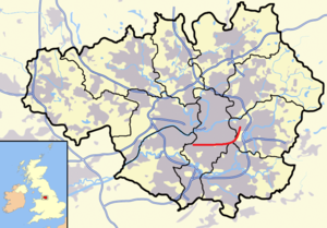
, crossing four metropolitan borough
Metropolitan borough
A metropolitan borough is a type of local government district in England, and is a subdivision of a metropolitan county. Created in 1974 by the Local Government Act 1972, metropolitan boroughs are defined in English law as metropolitan districts, however all of them have been granted or regranted...
s of present-day Greater Manchester
Greater Manchester
Greater Manchester is a metropolitan county in North West England, with a population of 2.6 million. It encompasses one of the largest metropolitan areas in the United Kingdom and comprises ten metropolitan boroughs: Bolton, Bury, Oldham, Rochdale, Stockport, Tameside, Trafford, Wigan, and the...
. The ditch coincides with the boundaries between the boroughs of Stockport
Metropolitan Borough of Stockport
The Metropolitan Borough of Stockport is a metropolitan borough of Greater Manchester, in north west England, centred around the town of Stockport. It has a population of about 280,600 and includes the outyling areas of Cheadle and Cheadle Hulme, Marple, Bredbury, Reddish and Romiley...
and Manchester
Manchester
Manchester is a city and metropolitan borough in Greater Manchester, England. According to the Office for National Statistics, the 2010 mid-year population estimate for Manchester was 498,800. Manchester lies within one of the UK's largest metropolitan areas, the metropolitan county of Greater...
, and between Tameside and Manchester as far as Denton golf course. A section is now beneath the Audenshaw Reservoirs
Audenshaw Reservoirs
The Audenshaw Reservoirs were constructed between 1877 and 1882 by Manchester Corporation. They are located in the townships of Audenshaw and Denton, Greater Manchester, in northern England. Their construction was overseen by John Frederick Bateman. Part of the original village of Audenshaw was...
, which were built towards the end of the 19th century. The ditch may have extended west beyond Stretford, to Urmston
Urmston
Urmston is a town within the Metropolitan Borough of Trafford, in Greater Manchester, England, with a population of around 41,000. Historically a part of Lancashire, it lies about six miles to the southwest of Manchester city centre. The southern boundary is marked by the River Mersey and the...
.
History
Nico Ditch was constructed some time between the end of Roman rule in Britain in the early 5th century and the Norman ConquestNorman conquest of England
The Norman conquest of England began on 28 September 1066 with the invasion of England by William, Duke of Normandy. William became known as William the Conqueror after his victory at the Battle of Hastings on 14 October 1066, defeating King Harold II of England...
in 1066. Its original purpose is unclear, but it may have been used as a defensive fortification or as an administrative boundary. It possibly marked a 7th-century boundary for the expansionist Anglo-Saxons, or it may have been a late 8th or early 9th-century boundary marker between the kingdoms of Mercia
Mercia
Mercia was one of the kingdoms of the Anglo-Saxon Heptarchy. It was centred on the valley of the River Trent and its tributaries in the region now known as the English Midlands...
and Northumbria
Northumbria
Northumbria was a medieval kingdom of the Angles, in what is now Northern England and South-East Scotland, becoming subsequently an earldom in a united Anglo-Saxon kingdom of England. The name reflects the approximate southern limit to the kingdom's territory, the Humber Estuary.Northumbria was...
. In the early medieval period, the kingdoms of Northumbria, Mercia, and Wessex
Wessex
The Kingdom of Wessex or Kingdom of the West Saxons was an Anglo-Saxon kingdom of the West Saxons, in South West England, from the 6th century, until the emergence of a united English state in the 10th century, under the Wessex dynasty. It was to be an earldom after Canute the Great's conquest...
struggled for control over North West England
North West England
North West England, informally known as The North West, is one of the nine official regions of England.North West England had a 2006 estimated population of 6,853,201 the third most populated region after London and the South East...
, as did the Britons
Britons (historical)
The Britons were the Celtic people culturally dominating Great Britain from the Iron Age through the Early Middle Ages. They spoke the Insular Celtic language known as British or Brythonic...
and Danes. Whatever its earlier use, the ditch has been used as a boundary since at least the Middle Ages
Middle Ages
The Middle Ages is a periodization of European history from the 5th century to the 15th century. The Middle Ages follows the fall of the Western Roman Empire in 476 and precedes the Early Modern Era. It is the middle period of a three-period division of Western history: Classic, Medieval and Modern...
.
Legend has it that Nico Ditch was completed in a single night by the inhabitants of Manchester, as a protection against Viking invaders in 869–870; Manchester may have been sacked
Looting
Looting —also referred to as sacking, plundering, despoiling, despoliation, and pillaging—is the indiscriminate taking of goods by force as part of a military or political victory, or during a catastrophe, such as during war, natural disaster, or rioting...
by the Danes in 870. It was said that each man had an allocated area to construct, and was required to dig his section of the ditch and build a bank equal to his own height. According to 19th-century folklore, the ditch was the site of a battle between Saxons and Danes; the battle was supposed to have given the nearby towns of Gorton and Reddish their names, from "Gore Town" and "Red-Ditch", but the idea has been dismissed by historians as a "popular fancy". The names derive from "dirty farmstead" and "reedy ditch" respectively.
Antiquarian
An antiquarian or antiquary is an aficionado or student of antiquities or things of the past. More specifically, the term is used for those who study history with particular attention to ancient objects of art or science, archaeological and historic sites, or historic archives and manuscripts...
s and historians have been interested in the ditch since the 19th century, but much of its course has been built over. Between 1990 and 1997, the University of Manchester Archaeological Unit excavated sections of the ditch in Denton, Reddish, Levenshulme, and Platt Fields, in an attempt to determine its age and purpose. Although no date was established for the ditch's construction, the investigations revealed that the bank to the north of the ditch is of 20th-century origin. Together with the ditch's profile, which is U-shaped rather than the V-shape typically used in military ditches and defences, this suggests that the purpose of the earthwork was to mark a territorial boundary. The conclusion of the project was that the ditch was probably a boundary marker.
Etymology
The earliest documented reference to the ditch is in a charter detailing the granting of land in AudenshawAudenshaw
Audenshaw is a town within the Metropolitan Borough of Tameside, in Greater Manchester, England. It is located on the east side of the River Tame, along the course of both the M60 motorway and the Ashton Canal, southwest of Ashton-under-Lyne and east of the city of Manchester...
to the monks of the Kersal Cell. In the document, dating from 1190 to 1212, the ditch is referred to as "Mykelldiche", and a magnum fossatum, Latin for "large ditch".
The name Nico (sometimes Nikker) for the ditch became established in the 19th and 20th centuries. It may have been derived from the Anglo-Saxon Hnickar
Nickar
Nickar is a demon or spirit in the Dictionnaire Infernal. In Scandinavian, Teutonic and Saxon mythology, Nickar are malevolent water spirits who drown people, torment fisherman, tip over boats and throw them to the tops of shore-side trees...
, a water spirit who seized and drowned unwary travellers, but the modern name is most likely a corruption of the name Mykelldiche and its variations, as the Anglo-Saxon word micel meant "big" or "great", harking back to the early 13th-century description of the ditch as magnum fossatum. An alternative derivation is that Nico comes from nǽcan, an Anglo-Saxon verb meaning "kill".
Current status
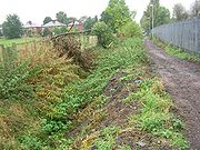
Despite heavy weathering, the ditch is still visible in short sections, which can be 3–4 metres wide and up to 1.5 metres deep. A 300-metre stretch through DentonDenton, Greater Manchester
Denton is a town within the Metropolitan Borough of Tameside, in Greater Manchester, England. It is five miles to the east of Manchester city centre, and has a population of 26,866....
golf course, and a section running through Platt Fields Park
Platt Fields Park
Platt Fields Park is a park off Wilmslow Road in Fallowfield, Manchester, England. It is home to Platt Hall, and was originally known as the Platt Estate or the Platt Hall Estate...
, are considered the best preserved remains. In 1997, a 135-metre long stretch of the ditch in Platt Fields was protected as a Scheduled Ancient Monument
Scheduled Ancient Monument
In the United Kingdom, a scheduled monument is a 'nationally important' archaeological site or historic building, given protection against unauthorized change. The various pieces of legislation used for legally protecting heritage assets from damage and destruction are grouped under the term...
. The rest of the ditch remains unprotected.