

Santiago Creek
Encyclopedia
Santiago Creek is a major watercourse in Orange County
in the U.S. state of California
. About 34 miles (54.7 km) long, it drains most of the northern Santa Ana Mountains
and is a tributary to the Santa Ana River
. It is one of the longest watercourses entirely within the county.
Historically the Santiago Creek provided water for the Tongva Native American group, whose territory extended over much of northern present-day Orange County and into the Los Angeles Basin
. Native Americans have inhabited the Santiago Creek and Santa Ana River watershed for at least 12,000 years. The creek was named by the Spanish Gaspar de Portolá
expedition of 1769, which crossed the Santa Ana River near the Santiago Creek confluence. A tributary of the creek was the subject of a short-lived silver boom in the 1870s. Present-day Santiago Peak
shares its name with the creek. Irvine Lake dam was constructed in 1929, marking the end of the creek's free-flowing state. The creek now contributes a small amount to the municipal water supply of Orange County via pipelines from Irvine Lake.
The Santiago Creek watershed covers about 100.6 mi2 in northern Orange County. Much of the upper course of the creek remains in its natural state, while the lower section is now urbanized and includes parts of the cities of Tustin
, Orange
, and Santa Ana
. The creek above Lake Irvine is perennial, but below the lake, the ephemeral
creek runs in a channelized course. Along the course of Santiago Creek, there are many recreational areas, including the Cleveland National Forest
and Irvine Regional Park.
and Modjeska Peak
, which together form the Saddleback formation. From there, the creek winds west-northwest for the first half of its course and southwest for the remaining half. It receives water from over five major tributaries and is free-flowing for most of the upper half of its course.
From the steep and narrow canyon between Santiago and Modjeska peaks, the creek runs south-southwest then turns sharply west, paralleling a ridge that separates it from the community of Portola Hills. It winds west-northwest, then after leaving the boundary of the national forest, it passes through the city of Modjeska and meets the first major tributary, Harding Canyon, from the right, 22 miles (35.4 km) from the mouth. As it continues bending northwards, Baker and Silverado
creeks merge with Santiago Creek from the right. As the creek passes underneath Santiago Canyon Road, the canyon widens to a broad alluvial valley. The valley walls pull away and decrease in height as the creek begins to sink into the soft deposits and is almost dry by the time it reaches the second Santiago Canyon Road crossing. The creek then empties into Irvine Lake, which is also fed by Limestone Canyon, a left-bank tributary.
Santiago Creek then exits the Santiago Creek Dam
, the dam forming Irvine Lake, 19 miles (30.6 km) from the mouth. The creek below the dam is initially an ephemeral watercourse due to diversions from the reservoir. Directly after leaving the dam the creek meets Fremont Canyon, a right bank tributary, and crosses underneath California State Route 241
. It then flows northwest, bisecting Irvine Regional Park, and receives a tributary from Weir Canyon from the right. It then is dammed by the Villa Park Dam to form a flood control reservoir as it enters the city of the same name
. The creek then flows in a flood control channel
for the remaining 7 miles (11.3 km) of its course.
Flowing roughly southwest between the cities of Orange
and Santa Ana
, and after receiving Handy Creek from the left, the creek then crosses under California State Route 55
and 22
, bisecting Hart Memorial Park and Santiago Creek Park in the process. The creek then crosses under Interstate 5 and continues west into the Santa Ana River. Its confluence is on the river's left bank, inside the Riverview Golf Course. About 10 miles (16.1 km) past the confluence with Santiago Creek, the Santa Ana River enters the Pacific Ocean
.
. It is bounded on the south by the San Diego Creek
, Aliso Creek and Oso Creek
drainage areas, on the southeast by the Trabuco Creek
watershed, and on the north and west by tributaries of the Santa Ana River. At 100.6 mi2 in size, the Santiago Creek watershed makes up about 3.6% of the entire 2400 mi2 Santa Ana River watershed - but makes up about 65.7% of the 153.2 mi2 of Santa Ana River watershed within Orange County, and 10.6% of 948 mi2 Orange County. Most of the watershed is unincorporated, but about a third lies within Anaheim
, Villa Park
, Orange
, and Santa Ana
.
Elevations in the watershed range from 5687 feet (1,733.4 m) at Santiago Peak to 108 feet (32.9 m) at the Santa Ana River confluence. Although only tiny parts of the Santiago Creek watershed do not lie within Orange County, it closely borders Riverside
and San Bernardino counties. The Santa Ana Mountains rise higher on the right bank of the creek (the north bank) than on the left (south) bank, and parts of the northernmost course of the creek run through the Puente Hills
.
The major tributary watersheds, in order of their appearance from southeast to northwest (roughly in downstream order) are: Harding Canyon, Williams Canyon, Silverado Canyon, Ladd Canyon (tributary of Silverado Canyon), Baker Canyon, Black Star Canyon
, Fremont Canyon, Blind Canyon, and Weir Canyon on the right bank; and Limestone Canyon and Handy Creek on the left bank. Of the right bank tributaries, the Silverado Canyon, Ladd Canyon and Fremont Canyon sub-watersheds each extend a little into Riverside County. The Silverado/Ladd Canyon subwatershed is the largest, and Williams Canyon is the smallest.
to the Quaternary
(251–2.6 MYA). These rocks consist primarily of slate
, sandstone
, conglomerate
, limestone
, and other sedimentary rock
s. The uplift of the Santa Ana Mountains began approximately 5.5 million years ago along the Elsinore Fault Zone, which extends north from near its namesake Lake Elsinore
area.
to its confluence with the Santa Ana River. Live oak
s, sycamore
s, alder
s, and other types riparian vegetation lined the banks of the creek and its major tributaries. The canyon supported a wide variety of birds, amphibians, fish and mammals.
s, mention that the Acjachemen lived along the upper Santiago Creek canyon.
The early inhabitants of the Santiago Creek Canyon lived in semi-permanent villages close to running water. The upper canyon belonged to the Acjachemen, while the lower (northwestern) part of the watershed, likely downstream of present-day Irvine Lake, was in Tongva land. They subsisted on a diet of primarily acorn
s, using the acorn powder to form a type of porridge
known as atole. The Native Americans had been drawn to the area by the abundant riparian zone
found along Santiago Creek and some of its perennial tributaries. They ground the acorns in stone mortar
s carved into huge boulders, and some of these mortars remain in the Santiago Creek area today.
expedition crossed the Santa Ana River very near the mouth of Santiago Creek. They named the creek for the Apostle
Saint James the Greater, as that day was July 25, his Feast Day. They named the canyon Cañada de Madera, or Timber Canyon. Santiago Peak
, then called Kalawpa by the Native Americans, was later renamed after the creek. The Spanish left accounts mentioning the Juaneño
, which was the name given to the Acjachemen by the Spanish after the founding of Mission San Juan Capistrano
farther southeast at the confluence of San Juan
and Trabuco
creeks. In the 1780s, a land grant
, the Rancho Santiago de Santa Ana
, was created on 78941 acres (319.5 km²) of land between Santiago Creek and the Santa Ana River, near the present-day sites of Orange
and Anaheim
.
The 25 miles (40.2 km)-long, 2.5 to 6.5 mi (4 to 10.5 km)-wide Rancho Santiago de Santa Ana was one of three adjoining rancho
s in the area, the Rancho San Joaquin and the Rancho Lomas de Santiago. One of the first settlers in the Santiago Creek watershed was Jose Pablo Grijalva, a former Spanish soldier, who arrived in 1784. He and his son-in-law, Jose Antonin Yorba, grazed cattle
in the Santiago Creek Canyon beginning in the 1790s. He built an adobe
house beside Santiago Creek in 1796. Later settlers included the Peraltas and Sepulvedas.
, which was called Cañada de los Indios (Indian Canyon) by the Spanish. This massacre was actually one in a series that involved the Native Americans' theft of horses from the Spanish ranchos. A party of American fur trappers was sent to take back some horses stolen by the Gabrielino. They followed hoofprints into Cañada de los Indios, and when they came upon a Native American village, they drove the people out and took back the remaining horses. Many Indians were killed in the process, but some managed to escape. The village site is now noted as California Historical Landmark
217.
In 1877, two prospectors, Hank Smith and William Curry, discovered silver in present-day Silverado Canyon. Several mines immediately sprang up in the area, the largest of which was known as the Blue Light Mine. During this period, the town of Silverado rose at the confluence of Silverado Creek and Santiago Creek and the boom continued for over three years. Although the height of the mining was in the three or four years following the discovery of silver, smaller-scale mining continued for decades after the initial boom had ended. The last commercial operations at the Blue Light Mine ceased in the 1940s. The mine has continued to issue small amounts of toxic tailings, including arsenic
, cadmium
, lead
, and mercury
, for which the Trabuco Ranger District of the Cleveland National Forest
began cleanup work on September 8, 2008.
In 1883, Helena Modjeska
, a well-known Polish actress, purchased a house in Santiago Canyon near the mouth of Harding Creek, the first large tributary. She hired an architect, Stanford White
, to build her a mansion in what is present-day Modjeska. She left the Santiago Canyon area in 1906, and three years later she died of an unknown reason. Modjeska Peak
, rising 5496 feet (1,675.2 m) above Santiago Creek's headwaters, was named in her honor.
was formed in 1928 and partnered with the Irvine Company
and El Modena
's Carpenter Irrigation District for the construction of Santiago Dam, impounding Lake Irvine
. Construction work begun in 1929 and the dam was completed in 1931. Eventually, the agricultural areas in the lower watershed were replaced by residential and commercial zones, but the city of Villa Park
and some of the city of Orange
still receive their water form Irvine Lake.
The Villa Park Dam, forming the Villa Park Reservoir further downstream on Santiago Creek, was completed in 1963 also by the Serrano Irrigation District, which by that time, had changed its name to the Serrano Water District. The lower course of Santiago Creek ended up being channelized in the mid-20th century after the passage of the Orange County Flood Control Act of 1927. The dam is now owned by the Orange County Flood Control Division.
s, and coyote
s. Today, the upper Santiago Creek remains much in its natural state, while the lower creek is listed as highly disturbed and no longer supports much native vegetation and wildlife.
Historically, the creek is known to have sustained a population of steelhead trout (Oncorhynchus mykiss), but with the construction of Villa Park and Santiago Creek dams, their anadromous spawning runs from the sea have been destroyed. However, 13 specimens of the land-locked form of steelhead, rainbow trout, were fin-sampled recently from Harding Canyon and genetic analysis has shown them to be of native and not hatchery stocks. Historically, at least two tributaries to Santiago Creek, Silverado and Harding Canyons, also supported steelhead. The watershed now primarily supports introduced fish in Lake Irvine.
, catfish
, and panfish
. The lake is still stocked weekly with fish.
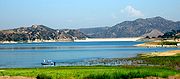 Irvine Regional Park, created in 1897, now occupies much of the lowermost Santiago Creek Canyon, between Santiago Creek Dam and Villa Park Reservoir. The park was created officially on October 5 of that year as "Orange County Park", and originally it consisted of 160 acre (0.6474976 km²) of woodland along the riparian course of Santago Creek. At first, Santiago Creek flowed freely through the park, but with the completion of Santiago Dam in 1931, that was no longer possible. A boating pond constructed in 1913 then had to be filled with water piped in from Lake Irvine. The park was expanded to its current size of 477 acres (1.9 km²) in 1971, and has hiking, fishing, boating, and a small zoo.
The Cleveland National Forest
was created in 1908 and expanded by 1925 to 424000 acres (1,715.9 km²). The upper Santiago Creek watershed now lies within the Trabuco Ranger District of the Cleveland National Forest. Several hiking trails run up the steep canyons in the upper Santiago Creek watershed, leading up tributaries such as Black Star Canyon and Silverado Canyon. The Joplin Trail leads up the canyon above the town of Modjeska to the summit of Modjeska Peak.
Other recreational areas and historic sites within the area include:
Orange County, California
Orange County is a county in the U.S. state of California. Its county seat is Santa Ana. As of the 2010 census, its population was 3,010,232, up from 2,846,293 at the 2000 census, making it the third most populous county in California, behind Los Angeles County and San Diego County...
in the U.S. state of California
California
California is a state located on the West Coast of the United States. It is by far the most populous U.S. state, and the third-largest by land area...
. About 34 miles (54.7 km) long, it drains most of the northern Santa Ana Mountains
Santa Ana Mountains
The Santa Ana Mountains are a short peninsular mountain range along the coast of Southern California in the United States. They extend for approximately 36 mi southeast of the Los Angeles Basin largely along the border between Orange and Riverside counties.- Geography :The range starts in the...
and is a tributary to the Santa Ana River
Santa Ana River
The Santa Ana River is the largest river of Southern California in the United States. Its drainage basin spans four counties. It rises in the San Bernardino Mountains and flows past the cities of San Bernardino and Riverside, before cutting through the northern tip of the Santa Ana Mountains and...
. It is one of the longest watercourses entirely within the county.
Historically the Santiago Creek provided water for the Tongva Native American group, whose territory extended over much of northern present-day Orange County and into the Los Angeles Basin
Los Angeles Basin
The Los Angeles Basin is the coastal sediment-filled plain located between the Peninsular and Transverse ranges in southern California in the United States containing the central part of the city of Los Angeles as well as its southern and southeastern suburbs...
. Native Americans have inhabited the Santiago Creek and Santa Ana River watershed for at least 12,000 years. The creek was named by the Spanish Gaspar de Portolá
Gaspar de Portolà
Gaspar de Portolà i Rovira was a soldier, governor of Baja and Alta California , explorer and founder of San Diego and Monterey. He was born in Os de Balaguer, province of Lleida, in Catalonia, Spain, of Catalan nobility. Don Gaspar served as a soldier in the Spanish army in Italy and Portugal...
expedition of 1769, which crossed the Santa Ana River near the Santiago Creek confluence. A tributary of the creek was the subject of a short-lived silver boom in the 1870s. Present-day Santiago Peak
Santiago Peak
Santiago Peak is the southern mountain of Orange County's Saddleback formation. It is the highest and most prominent peak of both the Santa Ana Mountains and Orange County, and also marks a border point with Riverside County. The top of it is covered with many microwave and telecommunication antennas...
shares its name with the creek. Irvine Lake dam was constructed in 1929, marking the end of the creek's free-flowing state. The creek now contributes a small amount to the municipal water supply of Orange County via pipelines from Irvine Lake.
The Santiago Creek watershed covers about 100.6 mi2 in northern Orange County. Much of the upper course of the creek remains in its natural state, while the lower section is now urbanized and includes parts of the cities of Tustin
Tustin, California
-Top employers:According to the City's 2010 Comprehensive Annual Financial Report, the top employers in the city are:-2010:The 2010 United States Census reported that Tustin had a population of 75,540. The population density was 6,816.7 people per square mile...
, Orange
Orange, California
Southern California is well-known for year-round pleasant weather: - On average, the warmest month is August. - The highest recorded temperature was in 1985. - On average, the coolest month is December. - The lowest recorded temperature was in 1950...
, and Santa Ana
Santa Ana, California
Santa Ana is the county seat and second most populous city in Orange County, California, and with a population of 324,528 at the 2010 census, Santa Ana is the 57th-most populous city in the United States....
. The creek above Lake Irvine is perennial, but below the lake, the ephemeral
Ephemeral
Ephemeral things are transitory, existing only briefly. Typically the term is used to describe objects found in nature, although it can describe a wide range of things....
creek runs in a channelized course. Along the course of Santiago Creek, there are many recreational areas, including the Cleveland National Forest
Cleveland National Forest
Cleveland National Forest encompasses 460,000 acres , mostly of chaparral, with a few riparian areas. A warm dry mediterranean climate prevails over the Forest. It is the southernmost National forest of California. It is administered by the United States Forest Service, a government agency within...
and Irvine Regional Park.
Course
The main stem of Santiago Creek rises in the Cleveland National Forest, between Santiago PeakSantiago Peak
Santiago Peak is the southern mountain of Orange County's Saddleback formation. It is the highest and most prominent peak of both the Santa Ana Mountains and Orange County, and also marks a border point with Riverside County. The top of it is covered with many microwave and telecommunication antennas...
and Modjeska Peak
Modjeska Peak
Modjeska Peak is the northern mountain of Orange County's Saddleback formation. It is the second highest peak of the Santa Ana Mountains.The peak is named for Shakespearean actress Helena Modjeska, who lived in its shadow near the end of her life....
, which together form the Saddleback formation. From there, the creek winds west-northwest for the first half of its course and southwest for the remaining half. It receives water from over five major tributaries and is free-flowing for most of the upper half of its course.
From the steep and narrow canyon between Santiago and Modjeska peaks, the creek runs south-southwest then turns sharply west, paralleling a ridge that separates it from the community of Portola Hills. It winds west-northwest, then after leaving the boundary of the national forest, it passes through the city of Modjeska and meets the first major tributary, Harding Canyon, from the right, 22 miles (35.4 km) from the mouth. As it continues bending northwards, Baker and Silverado
Silverado Canyon (Orange County)
Silverado Canyon is a roughly -deep gorge in the Santa Ana Mountains, in the U.S. state of California. The small stream it is associated with, Silverado Creek, rises on the north slope of Modjeska Peak at the elevation of and flows north and west, past the town of Silverado to join Santiago Creek...
creeks merge with Santiago Creek from the right. As the creek passes underneath Santiago Canyon Road, the canyon widens to a broad alluvial valley. The valley walls pull away and decrease in height as the creek begins to sink into the soft deposits and is almost dry by the time it reaches the second Santiago Canyon Road crossing. The creek then empties into Irvine Lake, which is also fed by Limestone Canyon, a left-bank tributary.
Santiago Creek then exits the Santiago Creek Dam
Santiago Dam
Santiago Dam is an earth/rockfill dam across Santiago Creek in Orange County, in the U.S. state of California, forming Irvine Lake. The earth dam and its reservoir serve for flood control and recreational purposes. It lies upstream from the city of Orange and north of Irvine...
, the dam forming Irvine Lake, 19 miles (30.6 km) from the mouth. The creek below the dam is initially an ephemeral watercourse due to diversions from the reservoir. Directly after leaving the dam the creek meets Fremont Canyon, a right bank tributary, and crosses underneath California State Route 241
California State Route 241
State Route 241 is a state highway in the U.S. state of California. For its entire run, Route 241 is a toll road. Its northern half is part of the Eastern Toll Road while its southern half is part of the Foothill Toll Road....
. It then flows northwest, bisecting Irvine Regional Park, and receives a tributary from Weir Canyon from the right. It then is dammed by the Villa Park Dam to form a flood control reservoir as it enters the city of the same name
Villa Park, California
Villa Park is a city in northern Orange County, California, near and surrounded by the City of Orange, and close to Anaheim Hills, that incorporated in 1962. As of the 2010 Census, the city had a population of 5,812, down from 5,999 at the 2000 census, achieving the status of the smallest city in...
. The creek then flows in a flood control channel
Flood control channel
Flood control channels are a series of large and empty open-air channels that extend a ways below the street levels of some larger cities, so that if and when a flood occurs, the flood will run into the channels, and proceed to be drained to the proper body of water...
for the remaining 7 miles (11.3 km) of its course.
Flowing roughly southwest between the cities of Orange
Orange, California
Southern California is well-known for year-round pleasant weather: - On average, the warmest month is August. - The highest recorded temperature was in 1985. - On average, the coolest month is December. - The lowest recorded temperature was in 1950...
and Santa Ana
Santa Ana, California
Santa Ana is the county seat and second most populous city in Orange County, California, and with a population of 324,528 at the 2010 census, Santa Ana is the 57th-most populous city in the United States....
, and after receiving Handy Creek from the left, the creek then crosses under California State Route 55
California State Route 55
State Route 55 is an 18-mile long north–south highway in the U.S. state of California. The portion of the route built to freeway standards is known as the Costa Mesa Freeway...
and 22
California State Route 22
State Route 22 in the U.S. state of California is an east–west highway in southern Los Angeles County and northern Orange County. It runs between Long Beach and Orange by way of Garden Grove. The westernmost part of it is a surface street, Long Beach's 7th Street. From Long Beach to its...
, bisecting Hart Memorial Park and Santiago Creek Park in the process. The creek then crosses under Interstate 5 and continues west into the Santa Ana River. Its confluence is on the river's left bank, inside the Riverview Golf Course. About 10 miles (16.1 km) past the confluence with Santiago Creek, the Santa Ana River enters the Pacific Ocean
Pacific Ocean
The Pacific Ocean is the largest of the Earth's oceanic divisions. It extends from the Arctic in the north to the Southern Ocean in the south, bounded by Asia and Australia in the west, and the Americas in the east.At 165.2 million square kilometres in area, this largest division of the World...
.
Watershed
The Santiago Creek watershed occupies much of the northwestern end of the Santa Ana Mountains, and is located generally north of the city of IrvineIrvine, California
Irvine is a suburban incorporated city in Orange County, California, United States. It is a planned city, mainly developed by the Irvine Company since the 1960s. Formally incorporated on December 28, 1971, the city has a population of 212,375 as of the 2010 census. However, the California...
. It is bounded on the south by the San Diego Creek
San Diego Creek
San Diego Creek is a waterway flowing into Upper Newport Bay in central Orange County in the U.S. state of California. Its basin covers in parts of eight cities, including Irvine, Tustin, and Costa Mesa. The major tributary of the northeast-flowing stream is Peters Canyon Wash, which joins a few...
, Aliso Creek and Oso Creek
Oso Creek
Oso Creek is an approximately tributary of Trabuco Creek in southern Orange County in the U.S. state of California. Draining about in a region north of the San Joaquin Hills and south of the Santa Ana Mountains, the creek is Trabuco Creek's largest tributary, and is part of the San Juan Creek...
drainage areas, on the southeast by the Trabuco Creek
Trabuco Creek
Trabuco Creek is a small river in the U.S. state of California, flowing from the westernmost extreme of Riverside County through Orange County to join San Juan Creek in the city of San Juan Capistrano. long, its watershed covers in southeastern Orange County, including portions of three...
watershed, and on the north and west by tributaries of the Santa Ana River. At 100.6 mi2 in size, the Santiago Creek watershed makes up about 3.6% of the entire 2400 mi2 Santa Ana River watershed - but makes up about 65.7% of the 153.2 mi2 of Santa Ana River watershed within Orange County, and 10.6% of 948 mi2 Orange County. Most of the watershed is unincorporated, but about a third lies within Anaheim
Anaheim, California
Anaheim is a city in Orange County, California. As of the 2010 United States Census, the city population was about 365,463, making it the most populated city in Orange County, the 10th most-populated city in California, and ranked 54th in the United States...
, Villa Park
Villa Park, California
Villa Park is a city in northern Orange County, California, near and surrounded by the City of Orange, and close to Anaheim Hills, that incorporated in 1962. As of the 2010 Census, the city had a population of 5,812, down from 5,999 at the 2000 census, achieving the status of the smallest city in...
, Orange
Orange, California
Southern California is well-known for year-round pleasant weather: - On average, the warmest month is August. - The highest recorded temperature was in 1985. - On average, the coolest month is December. - The lowest recorded temperature was in 1950...
, and Santa Ana
Santa Ana, California
Santa Ana is the county seat and second most populous city in Orange County, California, and with a population of 324,528 at the 2010 census, Santa Ana is the 57th-most populous city in the United States....
.
Elevations in the watershed range from 5687 feet (1,733.4 m) at Santiago Peak to 108 feet (32.9 m) at the Santa Ana River confluence. Although only tiny parts of the Santiago Creek watershed do not lie within Orange County, it closely borders Riverside
Riverside County, California
Riverside County is a county in the U.S. state of California. One of 58 California counties, it covers in the southern part of the state, and stretches from Orange County to the Colorado River, which forms the state border with Arizona. The county derives its name from the city of Riverside,...
and San Bernardino counties. The Santa Ana Mountains rise higher on the right bank of the creek (the north bank) than on the left (south) bank, and parts of the northernmost course of the creek run through the Puente Hills
Puente Hills
The Puente Hills is a chain of hills, one of the lower Transverse Ranges, in an unincorporated area in eastern Los Angeles County, California.-Geography:...
.
The major tributary watersheds, in order of their appearance from southeast to northwest (roughly in downstream order) are: Harding Canyon, Williams Canyon, Silverado Canyon, Ladd Canyon (tributary of Silverado Canyon), Baker Canyon, Black Star Canyon
Black Star Canyon
Black Star Canyon is a remote mountain canyon in the Santa Ana Mountains, located in eastern Orange County, California. It is a watershed of the Santa Ana River...
, Fremont Canyon, Blind Canyon, and Weir Canyon on the right bank; and Limestone Canyon and Handy Creek on the left bank. Of the right bank tributaries, the Silverado Canyon, Ladd Canyon and Fremont Canyon sub-watersheds each extend a little into Riverside County. The Silverado/Ladd Canyon subwatershed is the largest, and Williams Canyon is the smallest.
Tributaries
Santiago Creek has 10 major tributaries along its course, most of which come in while the creek flows through Santiago Canyon. Fremont Canyon is the largest by length, while Silverado Canyon is largest by size. The largest sub-tributary watershed is Ladd Canyon, a tributary of Silverado Canyon. Many of the upper tributaries are spring-fed and perennial. An uppercase R stands for right bank, and L is for left bank.| Tributary name | Length | Size | |
|---|---|---|---|
| Denomination | Miles | Kilometers | Rank |
| Harding Canyon (R) | 3.5 | 5.6 | 6 |
| Williams Canyon (R) | 1.3 | 2.1 | 10 |
| Silverado Canyon (R) | 10.8 | 17.3 | 1 |
| Ladd Canyon (Silverado Canyon tributary) (R) |
4.2 | 6.7 | 4 |
| Baker Canyon (R) | 5.5 | 8.9 | 8 |
| Black Star Canyon (R) | 8.5 | 13.7 | 3 |
| Lake Irvine Lake Irvine is a reservoir in Orange County, California. The lake is on Santiago Creek, is located northeast of the city of Irvine close to Irvine Regional Park.... |
|||
| Limestone Canyon (L) | 8.7 | 14.0 | 5 |
| Fremont Canyon (R) | 12.0 | 19.3 | 2 |
| Blind Canyon (R) | 2.4 | 3.9 | 11 |
| Weir Canyon (R) | 4.6 | 7.4 | 9 |
| Handy Creek (L) | 6.0 | 9.65 | 7 |
Santa Ana River The Santa Ana River is the largest river of Southern California in the United States. Its drainage basin spans four counties. It rises in the San Bernardino Mountains and flows past the cities of San Bernardino and Riverside, before cutting through the northern tip of the Santa Ana Mountains and... |
|||
Geology
The dominant geological feature in the Santiago Creek watershed are the Santa Ana Mountains. The northern portion of the mountains, which Santiago Creek drains, is composed of rocks from the pre-TriassicTriassic
The Triassic is a geologic period and system that extends from about 250 to 200 Mya . As the first period of the Mesozoic Era, the Triassic follows the Permian and is followed by the Jurassic. Both the start and end of the Triassic are marked by major extinction events...
to the Quaternary
Quaternary
The Quaternary Period is the most recent of the three periods of the Cenozoic Era in the geologic time scale of the ICS. It follows the Neogene Period, spanning 2.588 ± 0.005 million years ago to the present...
(251–2.6 MYA). These rocks consist primarily of slate
Slate
Slate is a fine-grained, foliated, homogeneous metamorphic rock derived from an original shale-type sedimentary rock composed of clay or volcanic ash through low-grade regional metamorphism. The result is a foliated rock in which the foliation may not correspond to the original sedimentary layering...
, sandstone
Sandstone
Sandstone is a sedimentary rock composed mainly of sand-sized minerals or rock grains.Most sandstone is composed of quartz and/or feldspar because these are the most common minerals in the Earth's crust. Like sand, sandstone may be any colour, but the most common colours are tan, brown, yellow,...
, conglomerate
Conglomerate (geology)
A conglomerate is a rock consisting of individual clasts within a finer-grained matrix that have become cemented together. Conglomerates are sedimentary rocks consisting of rounded fragments and are thus differentiated from breccias, which consist of angular clasts...
, limestone
Limestone
Limestone is a sedimentary rock composed largely of the minerals calcite and aragonite, which are different crystal forms of calcium carbonate . Many limestones are composed from skeletal fragments of marine organisms such as coral or foraminifera....
, and other sedimentary rock
Sedimentary rock
Sedimentary rock are types of rock that are formed by the deposition of material at the Earth's surface and within bodies of water. Sedimentation is the collective name for processes that cause mineral and/or organic particles to settle and accumulate or minerals to precipitate from a solution....
s. The uplift of the Santa Ana Mountains began approximately 5.5 million years ago along the Elsinore Fault Zone, which extends north from near its namesake Lake Elsinore
Lake Elsinore
Lake Elsinore, originally named Laguna Grande by the Spanish explorers, renamed for the town Lake Elsinore, California established on its northeastern shore April 9, 1888.-Limnology:...
area.
Setting
Hundreds of years ago, Santiago Creek was a free flowing perennial stream that spilled out of canyons in the Santa Ana Mountains and wound for the rest of its course over a broad, alluvial floodplainFloodplain
A floodplain, or flood plain, is a flat or nearly flat land adjacent a stream or river that stretches from the banks of its channel to the base of the enclosing valley walls and experiences flooding during periods of high discharge...
to its confluence with the Santa Ana River. Live oak
Live oak
Live oak , also known as the southern live oak, is a normally evergreen oak tree native to the southeastern United States...
s, sycamore
Sycamore
Sycamore is a name which is applied at various times and places to three very different types of trees, but with somewhat similar leaf forms....
s, alder
Alder
Alder is the common name of a genus of flowering plants belonging to the birch family . The genus comprises about 30 species of monoecious trees and shrubs, few reaching large size, distributed throughout the North Temperate Zone and in the Americas along the Andes southwards to...
s, and other types riparian vegetation lined the banks of the creek and its major tributaries. The canyon supported a wide variety of birds, amphibians, fish and mammals.
Native people
Most of the creek originally either lay in the territory of the Acjachemen or the Tongva, two large Native American groups of Orange, Los Angeles, and San Diego counties. The Acjachemen lived to the south and the Tongva to the north of Aliso Creek, a southwest-running stream that flows to the Pacific Ocean in an area generally to the southeast of the Santiago Creek watershed. As that part of the Acjachemen-Tongva boundary terminates at the Aliso Creek headwaters, it is uncertain whether Santiago Creek was part of which native group. However, archaeological evidence suggests that the upper portions of the creek were once settled by Native Americans, and some historical accounts, including that of the Spanish conquistadorConquistador
Conquistadors were Spanish soldiers, explorers, and adventurers who brought much of the Americas under the control of Spain in the 15th to 16th centuries, following Europe's discovery of the New World by Christopher Columbus in 1492...
s, mention that the Acjachemen lived along the upper Santiago Creek canyon.
The early inhabitants of the Santiago Creek Canyon lived in semi-permanent villages close to running water. The upper canyon belonged to the Acjachemen, while the lower (northwestern) part of the watershed, likely downstream of present-day Irvine Lake, was in Tongva land. They subsisted on a diet of primarily acorn
Acorn
The acorn, or oak nut, is the nut of the oaks and their close relatives . It usually contains a single seed , enclosed in a tough, leathery shell, and borne in a cup-shaped cupule. Acorns vary from 1–6 cm long and 0.8–4 cm broad...
s, using the acorn powder to form a type of porridge
Porridge
Porridge is a dish made by boiling oats or other cereal meals in water, milk, or both. It is usually served hot in a bowl or dish...
known as atole. The Native Americans had been drawn to the area by the abundant riparian zone
Riparian zone
A riparian zone or riparian area is the interface between land and a river or stream. Riparian is also the proper nomenclature for one of the fifteen terrestrial biomes of the earth. Plant habitats and communities along the river margins and banks are called riparian vegetation, characterized by...
found along Santiago Creek and some of its perennial tributaries. They ground the acorns in stone mortar
Mortar and pestle
A mortar and pestle is a tool used to crush, grind, and mix solid substances . The pestle is a heavy bat-shaped object, the end of which is used for crushing and grinding. The mortar is a bowl, typically made of hard wood, ceramic or stone...
s carved into huge boulders, and some of these mortars remain in the Santiago Creek area today.
Spanish occupancy
In 1769, the Gaspar de PortolaGaspar de Portolà
Gaspar de Portolà i Rovira was a soldier, governor of Baja and Alta California , explorer and founder of San Diego and Monterey. He was born in Os de Balaguer, province of Lleida, in Catalonia, Spain, of Catalan nobility. Don Gaspar served as a soldier in the Spanish army in Italy and Portugal...
expedition crossed the Santa Ana River very near the mouth of Santiago Creek. They named the creek for the Apostle
Apostle (Christian)
The term apostle is derived from Classical Greek ἀπόστολος , meaning one who is sent away, from στέλλω + από . The literal meaning in English is therefore an "emissary", from the Latin mitto + ex...
Saint James the Greater, as that day was July 25, his Feast Day. They named the canyon Cañada de Madera, or Timber Canyon. Santiago Peak
Santiago Peak
Santiago Peak is the southern mountain of Orange County's Saddleback formation. It is the highest and most prominent peak of both the Santa Ana Mountains and Orange County, and also marks a border point with Riverside County. The top of it is covered with many microwave and telecommunication antennas...
, then called Kalawpa by the Native Americans, was later renamed after the creek. The Spanish left accounts mentioning the Juaneño
Juaneño
The Juaneño or Acagchemem are a Native American group from Southern California. The Juaneño lived in what is now part of Orange and San Diego Counties and received their Spanish name from the priests of the California mission chain due to their proximity to Mission San Juan Capistrano...
, which was the name given to the Acjachemen by the Spanish after the founding of Mission San Juan Capistrano
Mission San Juan Capistrano
Mission San Juan Capistrano was a Spanish mission in Southern California, located in present-day San Juan Capistrano. It was founded on All Saints Day November 1, 1776, by Spanish Catholics of the Franciscan Order...
farther southeast at the confluence of San Juan
San Juan Creek
San Juan Creek, also called the San Juan River, is a stream in Orange County, California that consists of a catchment basin encompassing . Its mainstem rises in the Santa Ana Mountains, in the Trabuco Ranger District of the Cleveland National Forest...
and Trabuco
Trabuco Creek
Trabuco Creek is a small river in the U.S. state of California, flowing from the westernmost extreme of Riverside County through Orange County to join San Juan Creek in the city of San Juan Capistrano. long, its watershed covers in southeastern Orange County, including portions of three...
creeks. In the 1780s, a land grant
Land grant
A land grant is a gift of real estate – land or its privileges – made by a government or other authority as a reward for services to an individual, especially in return for military service...
, the Rancho Santiago de Santa Ana
Rancho Santiago de Santa Ana
Rancho Santiago de Santa Ana was a Spanish land concession in present day Orange County, California given by Governor José Joaquín de Arrillaga in 1810 to Jose Antonio Yorba and his nephew Pablo Peralta...
, was created on 78941 acres (319.5 km²) of land between Santiago Creek and the Santa Ana River, near the present-day sites of Orange
Orange, California
Southern California is well-known for year-round pleasant weather: - On average, the warmest month is August. - The highest recorded temperature was in 1985. - On average, the coolest month is December. - The lowest recorded temperature was in 1950...
and Anaheim
Anaheim, California
Anaheim is a city in Orange County, California. As of the 2010 United States Census, the city population was about 365,463, making it the most populated city in Orange County, the 10th most-populated city in California, and ranked 54th in the United States...
.
The 25 miles (40.2 km)-long, 2.5 to 6.5 mi (4 to 10.5 km)-wide Rancho Santiago de Santa Ana was one of three adjoining rancho
Ranchos of California
The Spanish, and later the Méxican government encouraged settlement of territory now known as California by the establishment of large land grants called ranchos, from which the English ranch is derived. Devoted to raising cattle and sheep, the owners of the ranchos attempted to pattern themselves...
s in the area, the Rancho San Joaquin and the Rancho Lomas de Santiago. One of the first settlers in the Santiago Creek watershed was Jose Pablo Grijalva, a former Spanish soldier, who arrived in 1784. He and his son-in-law, Jose Antonin Yorba, grazed cattle
Cattle
Cattle are the most common type of large domesticated ungulates. They are a prominent modern member of the subfamily Bovinae, are the most widespread species of the genus Bos, and are most commonly classified collectively as Bos primigenius...
in the Santiago Creek Canyon beginning in the 1790s. He built an adobe
Adobe
Adobe is a natural building material made from sand, clay, water, and some kind of fibrous or organic material , which the builders shape into bricks using frames and dry in the sun. Adobe buildings are similar to cob and mudbrick buildings. Adobe structures are extremely durable, and account for...
house beside Santiago Creek in 1796. Later settlers included the Peraltas and Sepulvedas.
American settlement
A well-known Native American massacre occurred in 1831 in present-day Black Star CanyonBlack Star Canyon
Black Star Canyon is a remote mountain canyon in the Santa Ana Mountains, located in eastern Orange County, California. It is a watershed of the Santa Ana River...
, which was called Cañada de los Indios (Indian Canyon) by the Spanish. This massacre was actually one in a series that involved the Native Americans' theft of horses from the Spanish ranchos. A party of American fur trappers was sent to take back some horses stolen by the Gabrielino. They followed hoofprints into Cañada de los Indios, and when they came upon a Native American village, they drove the people out and took back the remaining horses. Many Indians were killed in the process, but some managed to escape. The village site is now noted as California Historical Landmark
California Historical Landmark
California Historical Landmarks are buildings, structures, sites, or places in the state of California that have been determined to have statewide historical significance by meeting at least one of the criteria listed below:...
217.
In 1877, two prospectors, Hank Smith and William Curry, discovered silver in present-day Silverado Canyon. Several mines immediately sprang up in the area, the largest of which was known as the Blue Light Mine. During this period, the town of Silverado rose at the confluence of Silverado Creek and Santiago Creek and the boom continued for over three years. Although the height of the mining was in the three or four years following the discovery of silver, smaller-scale mining continued for decades after the initial boom had ended. The last commercial operations at the Blue Light Mine ceased in the 1940s. The mine has continued to issue small amounts of toxic tailings, including arsenic
Arsenic
Arsenic is a chemical element with the symbol As, atomic number 33 and relative atomic mass 74.92. Arsenic occurs in many minerals, usually in conjunction with sulfur and metals, and also as a pure elemental crystal. It was first documented by Albertus Magnus in 1250.Arsenic is a metalloid...
, cadmium
Cadmium
Cadmium is a chemical element with the symbol Cd and atomic number 48. This soft, bluish-white metal is chemically similar to the two other stable metals in group 12, zinc and mercury. Similar to zinc, it prefers oxidation state +2 in most of its compounds and similar to mercury it shows a low...
, lead
Lead
Lead is a main-group element in the carbon group with the symbol Pb and atomic number 82. Lead is a soft, malleable poor metal. It is also counted as one of the heavy metals. Metallic lead has a bluish-white color after being freshly cut, but it soon tarnishes to a dull grayish color when exposed...
, and mercury
Mercury (element)
Mercury is a chemical element with the symbol Hg and atomic number 80. It is also known as quicksilver or hydrargyrum...
, for which the Trabuco Ranger District of the Cleveland National Forest
Cleveland National Forest
Cleveland National Forest encompasses 460,000 acres , mostly of chaparral, with a few riparian areas. A warm dry mediterranean climate prevails over the Forest. It is the southernmost National forest of California. It is administered by the United States Forest Service, a government agency within...
began cleanup work on September 8, 2008.
In 1883, Helena Modjeska
Helena Modjeska
Helena Modjeska Helena Modjeska Helena Modjeska (October 12, 1840 – April 8, 1909, whose actual Polish surname was Modrzejewska , was a renowned actress who specialized in Shakespearean and tragic roles.Modjeska was the mother of Polish-American bridge engineer Ralph Modjeski....
, a well-known Polish actress, purchased a house in Santiago Canyon near the mouth of Harding Creek, the first large tributary. She hired an architect, Stanford White
Stanford White
Stanford White was an American architect and partner in the architectural firm of McKim, Mead & White, the frontrunner among Beaux-Arts firms. He designed a long series of houses for the rich and the very rich, and various public, institutional, and religious buildings, some of which can be found...
, to build her a mansion in what is present-day Modjeska. She left the Santiago Canyon area in 1906, and three years later she died of an unknown reason. Modjeska Peak
Modjeska Peak
Modjeska Peak is the northern mountain of Orange County's Saddleback formation. It is the second highest peak of the Santa Ana Mountains.The peak is named for Shakespearean actress Helena Modjeska, who lived in its shadow near the end of her life....
, rising 5496 feet (1,675.2 m) above Santiago Creek's headwaters, was named in her honor.
Water infrastructure
By the 1920s, the Orange/Anaheim/Villa Park area was a prospering agricultural region that depended on water from the Santa Ana River and Santiago Creek for irrigation. Santiago Creek would unleash seasonal floods in the winter and then dwindle to a trickle at the height of the dry season, creating problems for irrigation. The Serrano Irrigation DistrictIrrigation district
In the United States an irrigation district is a cooperative, self-governing public corporation set up as a subdivision of the State government, with definite geographic boundaries, organized, and having taxing power to obtain and distribute water for irrigation of lands within the district;...
was formed in 1928 and partnered with the Irvine Company
Irvine Company
The Irvine Company is a privately held real estate development company based in Newport Beach, Orange County, Southern California. The corporate center of the company lies in Newport Center. A large portion of its operations are centered in and around the City of Irvine, a planned city of 250,000...
and El Modena
El Modena, California
El Modena is an area around El Modena High School in the city of Orange, California. It is located near and east of the intersection of Hewes Street and Chapman Avenue...
's Carpenter Irrigation District for the construction of Santiago Dam, impounding Lake Irvine
Lake Irvine
Lake Irvine is a reservoir in Orange County, California. The lake is on Santiago Creek, is located northeast of the city of Irvine close to Irvine Regional Park....
. Construction work begun in 1929 and the dam was completed in 1931. Eventually, the agricultural areas in the lower watershed were replaced by residential and commercial zones, but the city of Villa Park
Villa Park, California
Villa Park is a city in northern Orange County, California, near and surrounded by the City of Orange, and close to Anaheim Hills, that incorporated in 1962. As of the 2010 Census, the city had a population of 5,812, down from 5,999 at the 2000 census, achieving the status of the smallest city in...
and some of the city of Orange
Orange, California
Southern California is well-known for year-round pleasant weather: - On average, the warmest month is August. - The highest recorded temperature was in 1985. - On average, the coolest month is December. - The lowest recorded temperature was in 1950...
still receive their water form Irvine Lake.
The Villa Park Dam, forming the Villa Park Reservoir further downstream on Santiago Creek, was completed in 1963 also by the Serrano Irrigation District, which by that time, had changed its name to the Serrano Water District. The lower course of Santiago Creek ended up being channelized in the mid-20th century after the passage of the Orange County Flood Control Act of 1927. The dam is now owned by the Orange County Flood Control Division.
Biology
Historically, Santiago Creek supported a rich riparian community along its shores. The Santa Ana Mountains supported a large population of California grizzly bear, now extinct, and other large mammals such as mountain lions, bobcatBobcat
The bobcat is a North American mammal of the cat family Felidae, appearing during the Irvingtonian stage of around 1.8 million years ago . With twelve recognized subspecies, it ranges from southern Canada to northern Mexico, including most of the continental United States...
s, and coyote
Coyote
The coyote , also known as the American jackal or the prairie wolf, is a species of canine found throughout North and Central America, ranging from Panama in the south, north through Mexico, the United States and Canada...
s. Today, the upper Santiago Creek remains much in its natural state, while the lower creek is listed as highly disturbed and no longer supports much native vegetation and wildlife.
Historically, the creek is known to have sustained a population of steelhead trout (Oncorhynchus mykiss), but with the construction of Villa Park and Santiago Creek dams, their anadromous spawning runs from the sea have been destroyed. However, 13 specimens of the land-locked form of steelhead, rainbow trout, were fin-sampled recently from Harding Canyon and genetic analysis has shown them to be of native and not hatchery stocks. Historically, at least two tributaries to Santiago Creek, Silverado and Harding Canyons, also supported steelhead. The watershed now primarily supports introduced fish in Lake Irvine.
Recreation
Lake Irvine was opened for fishing in 1941. A fishing license is not required to catch fish at the 700 acres (2.8 km²) reservoir. The lake was stocked with fish in the 1930s beginning with largemouth bassLargemouth bass
The largemouth bass is a species of black bass in the sunfish family native to North America . It is also known as widemouth bass, bigmouth, black bass, bucketmouth, Potter's fish, Florida bass, Florida largemouth, green bass, green trout, linesides, Oswego bass, southern largemouth...
, catfish
Catfish
Catfishes are a diverse group of ray-finned fish. Named for their prominent barbels, which resemble a cat's whiskers, catfish range in size and behavior from the heaviest and longest, the Mekong giant catfish from Southeast Asia and the second longest, the wels catfish of Eurasia, to detritivores...
, and panfish
Panfish
A panfish, also spelled pan-fish or pan fish, is an edible game fish that usually doesn't outgrow the size of a frying pan. The term is also commonly used by anglers to refer to any small catch that will fit in a pan, but is large enough to be legal. However its definition and usage varies with...
. The lake is still stocked weekly with fish.
The Cleveland National Forest
Cleveland National Forest
Cleveland National Forest encompasses 460,000 acres , mostly of chaparral, with a few riparian areas. A warm dry mediterranean climate prevails over the Forest. It is the southernmost National forest of California. It is administered by the United States Forest Service, a government agency within...
was created in 1908 and expanded by 1925 to 424000 acres (1,715.9 km²). The upper Santiago Creek watershed now lies within the Trabuco Ranger District of the Cleveland National Forest. Several hiking trails run up the steep canyons in the upper Santiago Creek watershed, leading up tributaries such as Black Star Canyon and Silverado Canyon. The Joplin Trail leads up the canyon above the town of Modjeska to the summit of Modjeska Peak.
Other recreational areas and historic sites within the area include:
- Tucker Wildlife SanctuaryTucker Wildlife SanctuaryTucker Wildlife Sanctuary is a non-profit nature reserve in Orange County, California in the United States, located near the end of Modjeska Canyon, at the foot of Modjeska Peak and adjacent to the Cleveland National Forest. The Sanctuary is owned and operated by California State University,...
- Arden Helena Modjeska House
- Limestone Canyon, Irvine Mesa, Baker Canyon, Black Star CanyonBlack Star CanyonBlack Star Canyon is a remote mountain canyon in the Santa Ana Mountains, located in eastern Orange County, California. It is a watershed of the Santa Ana River...
, and Fremont Canyon - Irvine Ranch Land Reserve
- Hidden Ranch, The Wildlands Conservancy
- Barham Ranch
- Santiago Oaks Regional Park
- El Modena Open Space
- El Modena High School Nature Center, Southern California Heritage Garden
- Grijalva Park
- Yorba Park
- Cambridge Restoration Area
- Hart Memorial Park
- Santiago Park Nature Reserve
- Santa Ana River Bike Trail