
San Diego Creek
Encyclopedia
San Diego Creek is a 16 miles (25.7 km) waterway flowing into Upper Newport Bay
in central Orange County
in the U.S. state
of California
. Its basin covers 112.2 mi2 in parts of eight cities, including Irvine
, Tustin
, and Costa Mesa
. The major tributary of the northeast-flowing stream is Peters Canyon Wash
, which joins a few miles above its mouth. Now mostly channelized, San Diego Creek serves an important function for flood control, but it has been extensively monitored for sediment loads. The purpose of this studying is that Upper Newport Bay, which San Diego Creek is the primary freshwater input of, is a rich ecological habitat and preserve.
Most of the watershed is residential or commercial, with large amounts of open space, nearly 15700 acres (63.5 km²). There are a few surviving pockets of agriculture
, although that has been mainly been taken over by more urban development. A large part of the basin is also occupied by the El Toro Marine Corps Air Base, which is being converted into the Orange County Great Park
. There are also some lands dedicated to industry. Interstate 5
and Interstate 405
run southeast-northwest through the watershed, which borders that of Santiago Creek
on the northeast, the Santa Ana River
on the northwest, and Aliso Creek on the southeast.
Its name is likely a corruption of that of Santiago Creek
, a river whose watershed borders San Diego Creek to the north and east.
near El Toro, Lake Forest
. Most of its upper course is culverted under residential subdivisions of El Toro and Irvine. It flows northeast, fed by tributaries from the northern extent of Laguna Canyon
and from the Santa Ana Mountains
to the north of the creek. After crossing under Interstate 405
, the creek immediately becomes channelized and receives Serrano Creek via an underground culvert on the right bank. Directly after the confluence, it crosses through five box-cut culverts beneath California State Route 133
. It then flows northeast in a nearly straight course through East Irvine and the City of Irvine, receiving several larger tributaries on the right bank. In order from upstream to most downstream, these are Agua Chinon Creek, Bee Canyon Wash, and the Marshburn Channel, all of which run south-southwest in a channelized course to San Diego Creek. A few miles past the confluence with Marshburn, San Diego Creek receives its major tributary, Peters Canyon Wash
, on the right bank. The wash begins at Peters Canyon Reservoir in the Santa Ana Mountains and runs about 10 miles (16.1 km) south-southwest. Although historically it was a smaller tributary, due to present-day flood control purposes, the channel of Peters Canyon is wider than the channel of San Diego Creek when they join.
 At the confluence with Peters Canyon, San Diego Creek turns abruptly southwest, flowing underneath Interstate 405 for the second time. After flowing beneath the highway, San Diego Creek enters a series of slackwater pools, held back by small weir
s and drop structure
s, called the San Joaquin Marsh. The partially man-made marsh stretches approximately 1.4 miles (2.3 km) to where San Diego Creek turns abruptly westward. The creek receives Bonita Creek on the left bank just a few hundred yards upstream frow where it outlets into Upper Newport Bay
, which eventually discharges into the Pacific Ocean
.
, agricultural runoff and other human-induced sources. According to the United States Environmental Protection Agency, average dry-season flow at the mouth is 8 cuft/s, whereas wet-season runoff can range from 800 cuft/s. On 6 December 1997, the highest recorded flow of 43500 cuft/s was recorded.
The peak streamflow data collected by the United States Geological Survey
at Campus Drive (near the mouth), with five recorded peaks, is given in the below table:
At Culver Drive, near the Irvine city center, 32 peaks were recorded. The largest five flows are given, in ascending order:
At Lane Road, which is well upstream of Culver Drive several miles below the headwaters of San Diego Creek, only three peaks were recorded:
that occupies the lower 1.4 miles (2.3 km) of the San Diego Creek stream course. Typically only 150 to 300 ft (45.7 to 91.4 m) wide, it is separated into a series of ponds by several low water rock dams, which also regulate streamflow. The marsh utilizes an ancient, perhaps once abandoned, river channel that discharges into Upper Newport Bay
. Roughly 100 migratory bird species currently use the marsh as a resting area, 20 nesting bird species are found, and a total of 200 different bird species have been cataloged. Although crossed by a number of bridges and fed by polluted water, the marsh also functions as an important facility to treat San Diego Creek water before discharging into the bay.
The marsh, which is currently the largest freshwater marsh in Orange County, was originally a severely polluted and degraded expanse after use as farmland and a duck-hunting area. Before the 1950s and 1960s, San Diego Creek had followed a much shorter, channelized course to the bay, leaving the marsh without a source of water. Agricultural runoff and later urban runoff
also polluted the site, leaving a remaining trickle of wastewater running through the marsh. In July 2000, the City of Irvine, which owns 300 acres (1.2 km²) of the marsh, contributed $1.5 million USD to its restoration, also with contributions from the Audubon Society and the State of California. The remaining 200 acre (0.809372 km²) belong to the University of California
and have been designated as the San Joaquin Freshwater Marsh Reserve.
A spreading ground, currently out of use, borders the marsh on the right bank, and the UC Irvine campus is on the left bank. Geologically, the marsh is an incised meander
in the creek, bending southwards. The old diversion channel bypassed the meander, and while that is still in use, it is only used to pass water around the marsh section during high flows.
), Serrano Creek
, Agua Chinon Creek, Bee Canyon Wash, Como Drain, Lyon Drain, Marshburn Channel, Coyote Canyon Channel, Peters Canyon Wash
, Barranca Channel, Lane Channel, San Joaquin Wash, Sand Canyon Wash
, and Bonita Creek.
The creek also has a few tributaries that provide the outflow for several water supply and flood control reservoirs in the San Joaquin Hills and Santa Ana Mountains. From source to mouth, these are La Cañada Channel (fed by Laguna Reservoir), Bee Canyon (two unnamed reservoirs), Peters Canyon Wash (Peters Canyon Reservoir), San Joaquin Wash (San Joaquin Reservoir) and Sand Canyon Wash (Sand Canyon and Strawberry Valley reservoirs).
The largest sub-tributaries include Borrego Canyon Wash (to Serrano Creek), Round Canyon (to Bee Canyon Wash), Santa Ana-Santa Fe Channel (to Peters Canyon) and Culver Drain (to San Joaquin Wash). There are many other ephemeral watercourses and drains in the watershed, but they are too numerous to list entirely.
Upper Newport Bay
The Upper Newport Bay is a large coastal wetland in Southern California and a major stopover for birds. Dozens of species, including endangered ones, can be observed here. Upper Newport Bay Nature Preserve and Ecological Reserve represent approximately 1,000 acres of open space...
in central Orange County
Orange County, California
Orange County is a county in the U.S. state of California. Its county seat is Santa Ana. As of the 2010 census, its population was 3,010,232, up from 2,846,293 at the 2000 census, making it the third most populous county in California, behind Los Angeles County and San Diego County...
in the U.S. state
U.S. state
A U.S. state is any one of the 50 federated states of the United States of America that share sovereignty with the federal government. Because of this shared sovereignty, an American is a citizen both of the federal entity and of his or her state of domicile. Four states use the official title of...
of California
California
California is a state located on the West Coast of the United States. It is by far the most populous U.S. state, and the third-largest by land area...
. Its basin covers 112.2 mi2 in parts of eight cities, including Irvine
Irvine, California
Irvine is a suburban incorporated city in Orange County, California, United States. It is a planned city, mainly developed by the Irvine Company since the 1960s. Formally incorporated on December 28, 1971, the city has a population of 212,375 as of the 2010 census. However, the California...
, Tustin
Tustin, California
-Top employers:According to the City's 2010 Comprehensive Annual Financial Report, the top employers in the city are:-2010:The 2010 United States Census reported that Tustin had a population of 75,540. The population density was 6,816.7 people per square mile...
, and Costa Mesa
Costa Mesa, California
Costa Mesa is a city in Orange County, California. The population was 109,960 at the 2010 census. Since its incorporation in 1953, the city has grown from a semi-rural farming community of 16,840 to a primarily suburban and "edge" city with an economy based on retail, commerce, and light...
. The major tributary of the northeast-flowing stream is Peters Canyon Wash
Peters Canyon Wash
Peters Canyon Wash is a tributary of San Diego Creek in central Orange County in the U.S. state of California. About long north-south, the wash, now mostly channelized, flows in a relatively straight course southwest from the Peters Canyon Reservoir, in the Santa Ana Mountains, through the cities...
, which joins a few miles above its mouth. Now mostly channelized, San Diego Creek serves an important function for flood control, but it has been extensively monitored for sediment loads. The purpose of this studying is that Upper Newport Bay, which San Diego Creek is the primary freshwater input of, is a rich ecological habitat and preserve.
Most of the watershed is residential or commercial, with large amounts of open space, nearly 15700 acres (63.5 km²). There are a few surviving pockets of agriculture
Agriculture
Agriculture is the cultivation of animals, plants, fungi and other life forms for food, fiber, and other products used to sustain life. Agriculture was the key implement in the rise of sedentary human civilization, whereby farming of domesticated species created food surpluses that nurtured the...
, although that has been mainly been taken over by more urban development. A large part of the basin is also occupied by the El Toro Marine Corps Air Base, which is being converted into the Orange County Great Park
Orange County Great Park
The Orange County Great Park is the official name of a plan for the public, non-aviation reuse of the decommissioned Marine Corps Air Station El Toro in Irvine, California. The county park will comprise just 28.8% of the total that made up the old MCAS El Toro base. It is a $1.1 billion project...
. There are also some lands dedicated to industry. Interstate 5
Interstate 5
Interstate 5 is the main Interstate Highway on the West Coast of the United States, running largely parallel to the Pacific Ocean coastline from Canada to Mexico . It serves some of the largest cities on the U.S...
and Interstate 405
Interstate 405
Interstate 405 may refer to:* Interstate 405 , a bypass of Los Angeles, California* Interstate 405 , a loop in Portland, Oregon* Interstate 405 , a bypass of Seattle, Washington...
run southeast-northwest through the watershed, which borders that of Santiago Creek
Santiago Creek
Santiago Creek is a major watercourse in Orange County in the U.S. state of California. About long, it drains most of the northern Santa Ana Mountains and is a tributary to the Santa Ana River...
on the northeast, the Santa Ana River
Santa Ana River
The Santa Ana River is the largest river of Southern California in the United States. Its drainage basin spans four counties. It rises in the San Bernardino Mountains and flows past the cities of San Bernardino and Riverside, before cutting through the northern tip of the Santa Ana Mountains and...
on the northwest, and Aliso Creek on the southeast.
Its name is likely a corruption of that of Santiago Creek
Santiago Creek
Santiago Creek is a major watercourse in Orange County in the U.S. state of California. About long, it drains most of the northern Santa Ana Mountains and is a tributary to the Santa Ana River...
, a river whose watershed borders San Diego Creek to the north and east.
Course
San Diego Creek rises in the extreme foothills of the Santa Ana MountainsSanta Ana Mountains
The Santa Ana Mountains are a short peninsular mountain range along the coast of Southern California in the United States. They extend for approximately 36 mi southeast of the Los Angeles Basin largely along the border between Orange and Riverside counties.- Geography :The range starts in the...
near El Toro, Lake Forest
Lake Forest, California
Lake Forest is a city in Orange County, California. The population was 77,264 at the 2010 census.Lake Forest incorporated as a city on December 20, 1991. Prior to a vote of the residents in that year, the community had formerly been known as El Toro since the 1880s...
. Most of its upper course is culverted under residential subdivisions of El Toro and Irvine. It flows northeast, fed by tributaries from the northern extent of Laguna Canyon
Laguna Canyon
Laguna Canyon is a canyon, formerly a water gap, that cuts through the San Joaquin Hills in southern Orange County in the U.S. state of California, directly west of the city of Irvine...
and from the Santa Ana Mountains
Santa Ana Mountains
The Santa Ana Mountains are a short peninsular mountain range along the coast of Southern California in the United States. They extend for approximately 36 mi southeast of the Los Angeles Basin largely along the border between Orange and Riverside counties.- Geography :The range starts in the...
to the north of the creek. After crossing under Interstate 405
Interstate 405
Interstate 405 may refer to:* Interstate 405 , a bypass of Los Angeles, California* Interstate 405 , a loop in Portland, Oregon* Interstate 405 , a bypass of Seattle, Washington...
, the creek immediately becomes channelized and receives Serrano Creek via an underground culvert on the right bank. Directly after the confluence, it crosses through five box-cut culverts beneath California State Route 133
California State Route 133
State Route 133 is a state highway in the U.S. state of California. It connects SR 1 in Laguna Beach through the San Joaquin Hills with several freeways in Irvine, ending at the SR 241 toll road in the latter city...
. It then flows northeast in a nearly straight course through East Irvine and the City of Irvine, receiving several larger tributaries on the right bank. In order from upstream to most downstream, these are Agua Chinon Creek, Bee Canyon Wash, and the Marshburn Channel, all of which run south-southwest in a channelized course to San Diego Creek. A few miles past the confluence with Marshburn, San Diego Creek receives its major tributary, Peters Canyon Wash
Peters Canyon Wash
Peters Canyon Wash is a tributary of San Diego Creek in central Orange County in the U.S. state of California. About long north-south, the wash, now mostly channelized, flows in a relatively straight course southwest from the Peters Canyon Reservoir, in the Santa Ana Mountains, through the cities...
, on the right bank. The wash begins at Peters Canyon Reservoir in the Santa Ana Mountains and runs about 10 miles (16.1 km) south-southwest. Although historically it was a smaller tributary, due to present-day flood control purposes, the channel of Peters Canyon is wider than the channel of San Diego Creek when they join.
Weir
A weir is a small overflow dam used to alter the flow characteristics of a river or stream. In most cases weirs take the form of a barrier across the river that causes water to pool behind the structure , but allows water to flow over the top...
s and drop structure
Drop structure
A drop structure, also known as a grade control, sill, or weir, is a manmade structure, typically small and built on minor streams, or as part of a dam's spillway, to pass water to a lower elevation while controlling the energy and velocity of the water as it passes over...
s, called the San Joaquin Marsh. The partially man-made marsh stretches approximately 1.4 miles (2.3 km) to where San Diego Creek turns abruptly westward. The creek receives Bonita Creek on the left bank just a few hundred yards upstream frow where it outlets into Upper Newport Bay
Upper Newport Bay
The Upper Newport Bay is a large coastal wetland in Southern California and a major stopover for birds. Dozens of species, including endangered ones, can be observed here. Upper Newport Bay Nature Preserve and Ecological Reserve represent approximately 1,000 acres of open space...
, which eventually discharges into the Pacific Ocean
Pacific Ocean
The Pacific Ocean is the largest of the Earth's oceanic divisions. It extends from the Arctic in the north to the Southern Ocean in the south, bounded by Asia and Australia in the west, and the Americas in the east.At 165.2 million square kilometres in area, this largest division of the World...
.
Streamflow
On average, the dry-season flow of San Diego Creek is partially if not entirely composed of urban runoffUrban runoff
Urban runoff is surface runoff of rainwater created by urbanization. This runoff is a major source of water pollution in many parts of the United States and other urban communities worldwide.-Overview:...
, agricultural runoff and other human-induced sources. According to the United States Environmental Protection Agency, average dry-season flow at the mouth is 8 cuft/s, whereas wet-season runoff can range from 800 cuft/s. On 6 December 1997, the highest recorded flow of 43500 cuft/s was recorded.
The peak streamflow data collected by the United States Geological Survey
United States Geological Survey
The United States Geological Survey is a scientific agency of the United States government. The scientists of the USGS study the landscape of the United States, its natural resources, and the natural hazards that threaten it. The organization has four major science disciplines, concerning biology,...
at Campus Drive (near the mouth), with five recorded peaks, is given in the below table:
| Year | Streamflow (cfs and m3/s) |
|---|---|
| 1978 | 9080 cuft/s |
| 1979 | 6400 cuft/s |
| 1983 | 15500 cuft/s |
| 1984 | 7100 cuft/s |
| 1985 | 3040 cuft/s |
At Culver Drive, near the Irvine city center, 32 peaks were recorded. The largest five flows are given, in ascending order:
| Year | Streamflow (cfs and m3/s) |
|---|---|
| 1952 | 4040 cuft/s |
| 1979 | 5550 cuft/s |
| 1978 | 6300 cuft/s |
| 1969 | 6700 cuft/s |
| 1983 | 10400 cuft/s |
At Lane Road, which is well upstream of Culver Drive several miles below the headwaters of San Diego Creek, only three peaks were recorded:
| Year | Streamflow (cfs and m3/s) |
|---|---|
| 1974 | 2360 cuft/s |
| 1975 | 4000 cuft/s |
| 1976 | 1035 cuft/s |
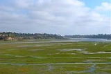
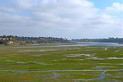
San Joaquin Marsh
The San Joaquin Marsh is a long and narrow, approximately 500 acres (2 km²) man-made wetlandWetland
A wetland is an area of land whose soil is saturated with water either permanently or seasonally. Wetlands are categorised by their characteristic vegetation, which is adapted to these unique soil conditions....
that occupies the lower 1.4 miles (2.3 km) of the San Diego Creek stream course. Typically only 150 to 300 ft (45.7 to 91.4 m) wide, it is separated into a series of ponds by several low water rock dams, which also regulate streamflow. The marsh utilizes an ancient, perhaps once abandoned, river channel that discharges into Upper Newport Bay
Upper Newport Bay
The Upper Newport Bay is a large coastal wetland in Southern California and a major stopover for birds. Dozens of species, including endangered ones, can be observed here. Upper Newport Bay Nature Preserve and Ecological Reserve represent approximately 1,000 acres of open space...
. Roughly 100 migratory bird species currently use the marsh as a resting area, 20 nesting bird species are found, and a total of 200 different bird species have been cataloged. Although crossed by a number of bridges and fed by polluted water, the marsh also functions as an important facility to treat San Diego Creek water before discharging into the bay.
The marsh, which is currently the largest freshwater marsh in Orange County, was originally a severely polluted and degraded expanse after use as farmland and a duck-hunting area. Before the 1950s and 1960s, San Diego Creek had followed a much shorter, channelized course to the bay, leaving the marsh without a source of water. Agricultural runoff and later urban runoff
Urban runoff
Urban runoff is surface runoff of rainwater created by urbanization. This runoff is a major source of water pollution in many parts of the United States and other urban communities worldwide.-Overview:...
also polluted the site, leaving a remaining trickle of wastewater running through the marsh. In July 2000, the City of Irvine, which owns 300 acres (1.2 km²) of the marsh, contributed $1.5 million USD to its restoration, also with contributions from the Audubon Society and the State of California. The remaining 200 acre (0.809372 km²) belong to the University of California
University of California
The University of California is a public university system in the U.S. state of California. Under the California Master Plan for Higher Education, the University of California is a part of the state's three-tier public higher education system, which also includes the California State University...
and have been designated as the San Joaquin Freshwater Marsh Reserve.
A spreading ground, currently out of use, borders the marsh on the right bank, and the UC Irvine campus is on the left bank. Geologically, the marsh is an incised meander
Meander
A meander in general is a bend in a sinuous watercourse. A meander is formed when the moving water in a stream erodes the outer banks and widens its valley. A stream of any volume may assume a meandering course, alternately eroding sediments from the outside of a bend and depositing them on the...
in the creek, bending southwards. The old diversion channel bypassed the meander, and while that is still in use, it is only used to pass water around the marsh section during high flows.
Tributaries
From north to south, the named tributaries of San Diego Creek are the La Cañada Channel (flowing from Laguna CanyonLaguna Canyon
Laguna Canyon is a canyon, formerly a water gap, that cuts through the San Joaquin Hills in southern Orange County in the U.S. state of California, directly west of the city of Irvine...
), Serrano Creek
Serrano Creek
Serrano Creek is a roughly tributary of San Diego Creek in the U.S. state of California. The creek starts in the Santa Ana Mountains in a canyon in Whiting Ranch Wilderness Park, near the boundary of the Cleveland National Forest. It then flows southwest into the city of Lake Forest, running in a...
, Agua Chinon Creek, Bee Canyon Wash, Como Drain, Lyon Drain, Marshburn Channel, Coyote Canyon Channel, Peters Canyon Wash
Peters Canyon Wash
Peters Canyon Wash is a tributary of San Diego Creek in central Orange County in the U.S. state of California. About long north-south, the wash, now mostly channelized, flows in a relatively straight course southwest from the Peters Canyon Reservoir, in the Santa Ana Mountains, through the cities...
, Barranca Channel, Lane Channel, San Joaquin Wash, Sand Canyon Wash
Sand Canyon Wash
Sand Canyon Wash is an approximately tributary of San Diego Creek in the U.S. state of California. Its headwaters rise in the northern San Joaquin Hills as two streams, Shady Canyon Creek and Bommer Canyon Creek, then northwest into Sand Canyon Reservoir, formed by a dam across Strawberry Valley...
, and Bonita Creek.
The creek also has a few tributaries that provide the outflow for several water supply and flood control reservoirs in the San Joaquin Hills and Santa Ana Mountains. From source to mouth, these are La Cañada Channel (fed by Laguna Reservoir), Bee Canyon (two unnamed reservoirs), Peters Canyon Wash (Peters Canyon Reservoir), San Joaquin Wash (San Joaquin Reservoir) and Sand Canyon Wash (Sand Canyon and Strawberry Valley reservoirs).
The largest sub-tributaries include Borrego Canyon Wash (to Serrano Creek), Round Canyon (to Bee Canyon Wash), Santa Ana-Santa Fe Channel (to Peters Canyon) and Culver Drain (to San Joaquin Wash). There are many other ephemeral watercourses and drains in the watershed, but they are too numerous to list entirely.
See also
- San Diego Creek bicycle pathSan Diego Creek bicycle pathThe San Diego Creek bicycle path is largely contained within the city of Irvine, California. The path begins where the San Diego Creek empties into Upper Newport Bay...
- List of rivers of Orange County, California