
Cleveland National Forest
Encyclopedia
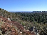
Cleveland National Forest encompasses 460,000 acre
s (720 mi2), mostly of chaparral
, with a few riparian areas. A warm dry mediterranean climate prevails over the Forest. It is the southernmost National forest
of California
. It is administered by the United States Forest Service
, a government agency within the United States Department of Agriculture
. It is divided into the Descanso, Palomar and Trabuco Ranger Districts and is located in the counties of San Diego, Riverside, and Orange
.
Cleveland National Forest was created on July 1, 1908 with the consolidation of Trabuco Canyon National Reserve and San Jacinto National Reserve by President Theodore Roosevelt and named after former president Grover Cleveland
. The Cleveland National Forest was the site of both of the largest wildfires in California history, the 2003 Cedar Fire
, and the Santiago Fire (2007)
. Both fires widely consumed many sections of the area, and endangered many animal species as well.
is required for parking in the Cleveland National Forest as well as other National Forests in Southern California
, and may be obtained from local merchants, visitor centers, or online.
Available on the Cleveland National Forest Official Site under Current Conditions are road, campground, picnic area, and trail closures.
"Law Enforcement Activities" are a common reason given for closures in the southern portion of the park. These closures are implemented to limit back road access in hopes of circumnavigating US Border Patrol checkpoints. Bear Valley Road coming up from Buckman Springs, Kitchen Creek Road and Thing Valley Road are among routes that are routinely restricted.
Besides climbers and wildlife advocates, the Forest Service must juggle demands from telecommunications companies, hunters, campers, utilities, off-road-vehicle enthusiasts, hikers, horse riders, neighbors and others. About 10 million people live within an hour’s drive of the three districts that make up the Cleveland National Forest.
The Cleveland National Forest has campgrounds available on the Descanso, Palomar, and Trabuco Ranger District. Sites normally serve 6-8 persons and 2 vehicles. Some campsites are first come first serve while others require reservations. More information located on Cleveland National Forest Official Site under Recreational Activities.
Group camping
Group campgrounds are located on all of their districts. Group campgrounds occupy larger groups of people ranging from 30 people to 100 people. They can be reserved by calling 1-877-444-6777 or online at Recreation.com. There is a 14 day limit.
Remote camping
The Cleveland National Forest welcomes remote camping. By obtaining a visitor's permit (acccesible on Cleveland National Forest Official Site under Passes & Permits), you can camp outside the Laguna Mountain Recreation Area and outside developed campgrounds on the National Forest land.
Acre
The acre is a unit of area in a number of different systems, including the imperial and U.S. customary systems. The most commonly used acres today are the international acre and, in the United States, the survey acre. The most common use of the acre is to measure tracts of land.The acre is related...
s (720 mi2), mostly of chaparral
Chaparral
Chaparral is a shrubland or heathland plant community found primarily in the U.S. state of California and in the northern portion of the Baja California peninsula, Mexico...
, with a few riparian areas. A warm dry mediterranean climate prevails over the Forest. It is the southernmost National forest
United States National Forest
National Forest is a classification of federal lands in the United States.National Forests are largely forest and woodland areas owned by the federal government and managed by the United States Forest Service, part of the United States Department of Agriculture. Land management of these areas...
of California
Southern California
Southern California is a megaregion, or megapolitan area, in the southern area of the U.S. state of California. Large urban areas include Greater Los Angeles and Greater San Diego. The urban area stretches along the coast from Ventura through the Southland and Inland Empire to San Diego...
. It is administered by the United States Forest Service
United States Forest Service
The United States Forest Service is an agency of the United States Department of Agriculture that administers the nation's 155 national forests and 20 national grasslands, which encompass...
, a government agency within the United States Department of Agriculture
United States Department of Agriculture
The United States Department of Agriculture is the United States federal executive department responsible for developing and executing U.S. federal government policy on farming, agriculture, and food...
. It is divided into the Descanso, Palomar and Trabuco Ranger Districts and is located in the counties of San Diego, Riverside, and Orange
Orange County, California
Orange County is a county in the U.S. state of California. Its county seat is Santa Ana. As of the 2010 census, its population was 3,010,232, up from 2,846,293 at the 2000 census, making it the third most populous county in California, behind Los Angeles County and San Diego County...
.
Cleveland National Forest was created on July 1, 1908 with the consolidation of Trabuco Canyon National Reserve and San Jacinto National Reserve by President Theodore Roosevelt and named after former president Grover Cleveland
Grover Cleveland
Stephen Grover Cleveland was the 22nd and 24th president of the United States. Cleveland is the only president to serve two non-consecutive terms and therefore is the only individual to be counted twice in the numbering of the presidents...
. The Cleveland National Forest was the site of both of the largest wildfires in California history, the 2003 Cedar Fire
Cedar Fire
The Cedar Fire was a human-caused wildfire that burned out of control through a large area of San Diego County, in Southern California, in October 2003...
, and the Santiago Fire (2007)
Santiago Fire
The Santiago Fire was an intentionally started wildfire located near Santiago Canyon in Orange County, California, U.S., and one of twenty-three California wildfires of October 2007.-The fire:...
. Both fires widely consumed many sections of the area, and endangered many animal species as well.
Districts
- Trabuco Ranger District (generally the northern area)
- Consists most of the Santa Ana MountainsSanta Ana MountainsThe Santa Ana Mountains are a short peninsular mountain range along the coast of Southern California in the United States. They extend for approximately 36 mi southeast of the Los Angeles Basin largely along the border between Orange and Riverside counties.- Geography :The range starts in the...
and is bisected by the Ortega HighwayCalifornia State Route 74State Route 74 , a part of the Pines to Palms Scenic Byway, is a mostly scenic highway in the U.S. state of California. It runs from Palm Desert in Riverside County westward to San Juan Capistrano in Orange County.-Route description:...
, which runs from San Juan Capistrano to Lake ElsinoreLake Elsinore, CaliforniaFor the lake see Lake Elsinore.Lake Elsinore or LE is a city in western Riverside County, California. The population was 51,821 at the 2010 census...
.
- Consists most of the Santa Ana Mountains
- Palomar Ranger District (near the cities of Escondido and RamonaRamona, CaliforniaRamona is a census-designated place in San Diego County, California. The population was 20,292 at the 2010 census.The term Ramona also refers to an unincorporated community that includes both the Ramona CDP and the adjacent CDP of San Diego Country Estates CDP...
)- Includes the "Highway to the Stars" from State Route 76 to the top of Palomar MountainPalomar MountainPalomar Mountain is a mountain in the Peninsular Ranges in northern San Diego County. It is famous as the location of the Palomar Observatory and Hale Telescope, and known for the Palomar Mountain State Park.-History:...
.
- Includes the "Highway to the Stars" from State Route 76 to the top of Palomar Mountain
- Descanso Ranger District (east of the city of El Cajon)
- Includes Sunrise Highway, a National Scenic Byway.
Use restrictions
A National Forest Adventure PassNational Forest Adventure Pass
The National Forest Adventure Pass is a recreation fee pass issued by the United States Forest Service that permits bearers in the four National Forests in Southern California to park their cars for the purpose of recreation...
is required for parking in the Cleveland National Forest as well as other National Forests in Southern California
Southern California
Southern California is a megaregion, or megapolitan area, in the southern area of the U.S. state of California. Large urban areas include Greater Los Angeles and Greater San Diego. The urban area stretches along the coast from Ventura through the Southland and Inland Empire to San Diego...
, and may be obtained from local merchants, visitor centers, or online.
Available on the Cleveland National Forest Official Site under Current Conditions are road, campground, picnic area, and trail closures.
"Law Enforcement Activities" are a common reason given for closures in the southern portion of the park. These closures are implemented to limit back road access in hopes of circumnavigating US Border Patrol checkpoints. Bear Valley Road coming up from Buckman Springs, Kitchen Creek Road and Thing Valley Road are among routes that are routinely restricted.
Activities
Popular activities include picnic areas, hiking through the mountains on foot, exploring on horseback, camping overnight or driving on the Sunrise Scenic Highway. The Forest also includes Corral Canyon and Wildomar Off-Highway Vehicle Areas.Besides climbers and wildlife advocates, the Forest Service must juggle demands from telecommunications companies, hunters, campers, utilities, off-road-vehicle enthusiasts, hikers, horse riders, neighbors and others. About 10 million people live within an hour’s drive of the three districts that make up the Cleveland National Forest.
Camping
CampgroundsThe Cleveland National Forest has campgrounds available on the Descanso, Palomar, and Trabuco Ranger District. Sites normally serve 6-8 persons and 2 vehicles. Some campsites are first come first serve while others require reservations. More information located on Cleveland National Forest Official Site under Recreational Activities.
Group camping
Group campgrounds are located on all of their districts. Group campgrounds occupy larger groups of people ranging from 30 people to 100 people. They can be reserved by calling 1-877-444-6777 or online at Recreation.com. There is a 14 day limit.
Remote camping
The Cleveland National Forest welcomes remote camping. By obtaining a visitor's permit (acccesible on Cleveland National Forest Official Site under Passes & Permits), you can camp outside the Laguna Mountain Recreation Area and outside developed campgrounds on the National Forest land.
See also
- ChaparralChaparralChaparral is a shrubland or heathland plant community found primarily in the U.S. state of California and in the northern portion of the Baja California peninsula, Mexico...
- California chaparral and woodlandsCalifornia chaparral and woodlandsThe California chaparral and woodlands is a terrestrial ecoregion of lower northern, central, and southern California and northwestern Baja California , located on the west coast of North America...
- California montane chaparral and woodlandsCalifornia montane chaparral and woodlandsThe California montane chaparral and woodlands ecoregion covers , including the mountains of the Transverse, Peninsular, and Santa Lucia Ranges of California. It is part of the Mediterranean forests, woodlands, and scrub biome, with cool, wet winters and hot, dry summers...
- California oak woodlandCalifornia oak woodlandCalifornia oak woodland is a plant community found throughout the California chaparral and woodlands ecoregion of California in the United States and northwestern Baja California in Mexico...
s
- California montane chaparral and woodlands
External links
- Cleveland National Forest Official Site
- In-depth article by the San Diego Historical Society
- Southern California Trails at Local Hikes
- The Nature Conservancy: Santa Ana Mountains
- Santa Ana Mountains Wild Heritage Project
- Center For Biological Diversity
- Santa Ana Mountains Natural History Association