

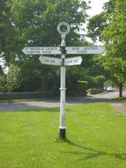
Fingerpost
Encyclopedia

United Kingdom
The United Kingdom of Great Britain and Northern IrelandIn the United Kingdom and Dependencies, other languages have been officially recognised as legitimate autochthonous languages under the European Charter for Regional or Minority Languages...
and Irish
Republic of Ireland
Ireland , described as the Republic of Ireland , is a sovereign state in Europe occupying approximately five-sixths of the island of the same name. Its capital is Dublin. Ireland, which had a population of 4.58 million in 2011, is a constitutional republic governed as a parliamentary democracy,...
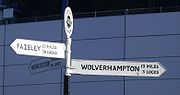
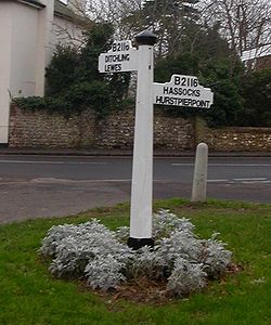
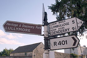
sign posts comprising a post with one or more arms — known as fingers — pointing in the direction of travel to named places on the fingers. They are typically made from cast-iron or wood, with poles painted in black, white or grey, and fingers with black letters on a white background and often include distance information in miles. In most cases, they are used to give guidance for road users - but examples also exist on the canal network, for instance.
Early history
Legislation was enacted in England in 1697 which enabled magistrates to place direction posts at cross-highways. However, the oldest fingerpost still extant is thought to be that close to Chipping CampdenChipping Campden
Chipping Campden is a small market town within the Cotswold district of Gloucestershire, England. It is notable for its elegant terraced High Street, dating from the 14th century to the 17th century...
in Gloucestershire
Gloucestershire
Gloucestershire is a county in South West England. The county comprises part of the Cotswold Hills, part of the flat fertile valley of the River Severn, and the entire Forest of Dean....
, dated 1669 and pointing to Oxford, Warwick, Gloucester and Worcester (abbreviated to 'Gloster' and 'Woster'). The Highways Act 1766 and Turnpike Roads Act 1773 made use of fingerposts on turnpike roads compulsory.
20th-century history
The Motor Car Act 1903Motor Car Act 1903
The Motor Car Act 1903 introduced registration of motor cars and licensing of drivers in the United Kingdom and increased the speed limit.-Context:...
passed road sign responsibilities to the relevant highway authority
Highway Authority
A highway authority is a name given to a body responsible for the administration of public roads.-India:The National Highways Authority of India is the national authority for the management of a network of over 60,000 km of National Highways in India...
, although no specifications were set. Guidance was given in a 1921 circular that road direction signs should have 2+1/2 or upper case lettering on a white background and white supporting poles. It also recommended that the name of the highway authority be included somewhere in the design.
Mandatory standards (The Traffic Signs (Size, Colour and Type) Provisional Regulations) were passed in 1933 which required poles to painted with black and white bands and lettering to be of a different typeface. Signposts were removed during World War II
World War II
World War II, or the Second World War , was a global conflict lasting from 1939 to 1945, involving most of the world's nations—including all of the great powers—eventually forming two opposing military alliances: the Allies and the Axis...
, lest enemy forces use them for navigation, and replaced in the late 1940s.
Road signing was next comprehensively reviewed from 1961 by the government-appointed Worboys Committee
Worboys Committee
The Worboys Committee was formed by the British government in July 1963 to review signage on all British roads. This was in response to two articles published in 1961 by graphic designer Herbert Spencer, illustrating the shortcomings of non-motorway British road signs.The committee was chaired by...
and the 1964 Traffic Signs Regulations brought in the signing system largely remaining in force today. Whilst the 1964 regulations did encourage local authorities to remove and replace traditional fingerposts with the new designs, it was not made compulsory to do so. Regulations did not however permit new fingerpost style signs to be erected until a design was permitted by the Department for the Environment
Secretary of State for the Environment
The Secretary of State for the Environment was a UK cabinet position, responsible for the Department of the Environment . This was created by Edward Heath as a combination of the Ministry of Housing and Local Government, the Ministry of Transport and the Ministry of Public Building and Works on 15...
in 1994 (in the Traffic Signs Regulations and General Directions of that year). Of note was that the design did not allow for mileages of over three miles to be expressed with the use of halves and quarters. It is thus that new fingerposts have been required to round the previously more accurate distance measurements.
Whilst the 1964 regulations did not bring about a general requirement to remove all fingerposts, some counties appear to have been more zealous than others in eradicating them. Fingerpost survival is highest in rural areas and away from major roads. Reacting to concern about the loss of historic fingerposts from the rural landscape, an advisory leaflet was issued by the Department for Transport
Department for Transport
In the United Kingdom, the Department for Transport is the government department responsible for the English transport network and a limited number of transport matters in Scotland, Wales and Northern Ireland which are not devolved...
and English Heritage
English Heritage
English Heritage . is an executive non-departmental public body of the British Government sponsored by the Department for Culture, Media and Sport...
in June 2005 which stated that "All surviving traditional fingerpost direction signs should be retained in-situ and maintained on a regular basis. They should be repainted every five years in traditional black and white livery. Other colours should be used only when these are known to have been in use before 1940". In recent years several county councils have embarked on restoration and repair programmes for their fingerpost stock, including the Highway Heritage Project in the Quantock Hills
Quantock Hills
The Quantock Hills is a range of hills west of Bridgwater in Somerset, England. The Quantock Hills were England’s first Area of Outstanding Natural Beauty being designated in 1956 and consists of large amounts of heathland, oak woodlands, ancient parklands and agricultural land.The hills run from...
of Somerset
Somerset
The ceremonial and non-metropolitan county of Somerset in South West England borders Bristol and Gloucestershire to the north, Wiltshire to the east, Dorset to the south-east, and Devon to the south-west. It is partly bounded to the north and west by the Bristol Channel and the estuary of the...
.
Local variation in historic designs
Whilst some elements of fingerpost design were prescribed during the period when their introduction became most widespread, there was plenty of scope for distinctive spread of designs which remains to today.The inclusion of the highway authority name took the form of raised or recessed lettering written down the poles or as part of a finial
Finial
The finial is an architectural device, typically carved in stone and employed decoratively to emphasize the apex of a gable or any of various distinctive ornaments at the top, end, or corner of a building or structure. Smaller finials can be used as a decorative ornament on the ends of curtain rods...
or roundel
Roundel
A roundel in heraldry is a disc; the term is also commonly used to refer to a type of national insignia used on military aircraft, generally circular in shape and usually comprising concentric rings of different colours.-Heraldry:...
(when the centre is hollow, called an annulus
Annulus (mathematics)
In mathematics, an annulus is a ring-shaped geometric figure, or more generally, a term used to name a ring-shaped object. Or, it is the area between two concentric circles...
) design, either in full or as initials (e.g. K.C.C. for Kesteven
Kesteven
The Parts of Kesteven are a traditional subdivision of Lincolnshire, England. This subdivision had long had a separate county administration , along with the other two parts, Lindsey and Holland.-Etymology:...
County Council). Roundel designs can also include junction names (for example, Molly Brown's Corner, in Lytchett Matravers
Lytchett Matravers
Lytchett Matravers is a large village and civil parish in the District of Purbeck within Dorset, England. The village has a population of 3,309.-Location:...
, Dorset
Dorset
Dorset , is a county in South West England on the English Channel coast. The county town is Dorchester which is situated in the south. The Hampshire towns of Bournemouth and Christchurch joined the county with the reorganisation of local government in 1974...
) or village names. County Council coats of arms feature in counties such as West Sussex
West Sussex
West Sussex is a county in the south of England, bordering onto East Sussex , Hampshire and Surrey. The county of Sussex has been divided into East and West since the 12th century, and obtained separate county councils in 1888, but it remained a single ceremonial county until 1974 and the coming...
. The Ministry for Transport asked the County Councils in Dorset and the West Riding of Yorkshire
West Riding of Yorkshire
The West Riding of Yorkshire is one of the three historic subdivisions of Yorkshire, England. From 1889 to 1974 the administrative county, County of York, West Riding , was based closely on the historic boundaries...
to experiment with the inclusion of a grid reference
Grid reference
Grid references define locations on maps using Cartesian coordinates. Grid lines on maps define the coordinate system, and are numbered to provide a unique reference to features....
and these remain common in these areas. The roundel on a 2005 replacement at West Wellow (Hampshire) directing travellers to St Margaret's Church bears a portrait of Florence Nightingale who is interred at the churchyard.
Fingers can be square-ended (such as in Cornwall
Cornwall
Cornwall is a unitary authority and ceremonial county of England, within the United Kingdom. It is bordered to the north and west by the Celtic Sea, to the south by the English Channel, and to the east by the county of Devon, over the River Tamar. Cornwall has a population of , and covers an area of...
and Norfolk
Norfolk
Norfolk is a low-lying county in the East of England. It has borders with Lincolnshire to the west, Cambridgeshire to the west and southwest and Suffolk to the south. Its northern and eastern boundaries are the North Sea coast and to the north-west the county is bordered by The Wash. The county...
), curved (as in Dorset) or triangular-ended (as is common in Somerset). Where timber was used for the fingers, place names are composed of individually affixed metal letters. Mileage is typically measured to the nearest quarter mile, with fractions being mounted on a separate ready-made plate, although measurements to the fifth- or eighth- of a mile are given in East Lothian. Due to their age, some fingerposts have 'fossilised' the historic spelling of places which was dominant at the time of their construction. Examples include "Portisham", rather than the modern spelling "Portesham
Portesham
Portesham is a village in the English county of Dorset, situated close to the south coast, between the towns of Weymouth and Dorchester. The village has a population of 708...
" and the pre-decimal "6D Handley" for Sixpenny Handley in Dorset.
Some fingerpost arm examples include the A- or B-road number as well as the destination, although many more of these examples were removed and replaced after the 1964 regulations were introduced. It appears that the original convention was for A-road numbers to be in white on a black background and the converse arrangement for B-road numbers, although there are few fingerposts with this as their current scheme.
Although most fingerposts are a combination of black, white or grey, other colour variants exist. The most well-known are the small number of Red Posts which are found in some of the southern English counties, including four in Dorset, including one on the A31
A31 road
The A31 is a major trunk road in southern England that runs from Guildford in Surrey to Bere Regis in Dorset.-Route of road:The road begins in the centre of Guildford, meeting the A3 road before running south west along the Hog's Back. It continues past Farnham, Alton and New Alresford before...
trunk road
Trunk road
A trunk road, trunk highway, or strategic road is a major road—usually connecting two or more cities, ports, airports, and other things.—which is the recommended route for long-distance and freight traffic...
at Anderson
Anderson, Dorset
Anderson is a village and civil parish in the North Dorset district of Dorset, England, with a population of 72 . The village is sometimes known as Winterborne Anderson, and is near Winterborne Zelston and Winterborne Kingston. It is about twelve miles by road from Poole.To the west is...
, between Bere Regis
Bere Regis
Bere Regis is a village in the Purbeck district of Dorset, England, situated north-west of Wareham.The village has one shop, a post office and two pubs, The Royal Oak and The Drax Arms. The parish church is St. John the Baptist Church...
and Wimborne Minster
Wimborne Minster
Wimborne Minster is a market town in the East Dorset district of Dorset in South West England, and the name of the Church of England church in that town...
. The others are located at Benville Bridge, Hewood Corner and near Poyntington. Various theories have been put forward as to their colour, including being to mark routes used by prisoners on their way to port for transportation to Australia, or the site of a gibbet
Gibbet
A gibbet is a gallows-type structure from which the dead bodies of executed criminals were hung on public display to deter other existing or potential criminals. In earlier times, up to the late 17th century, live gibbeting also took place, in which the criminal was placed alive in a metal cage...
. Other places have fingerpost arms with white writing on a green background which indicates the most minor of lanes, sometimes known as 'drift roads'.
Post-Worboys fingerpost designs
Some highway authorities chose to apply the spirit of the Worboys regulations in a fingerpost style, including the use of the Transport HeavyTransport (typeface)
Transport is a sans serif typeface designed for road signs in the United Kingdom. It was created between 1957 and 1963 by Jock Kinneir and Margaret Calvert as part of their work as designers for the Department of Transport's Anderson and Worboys committees....
typeface. Arm materials have tended either to be aluminium or plastic. Devon County Council introduced triangular-ended fingerposts with edges in four different colours to illustrate the suitability of the route for various types of vehicles, from black (for most vehicles, on A- and B-roads), through blue and brown to fully white fingers, indicating local access only. This system was entitled the Functional Road Network. Suffolk
Suffolk
Suffolk is a non-metropolitan county of historic origin in East Anglia, England. It has borders with Norfolk to the north, Cambridgeshire to the west and Essex to the south. The North Sea lies to the east...
County Council, too, adopted the use of Transport Heavy typefaces on square-ended fingers, and here distances over three miles are still given to the nearest quarter.
Literary references
The term "fingerpost" recently received some attention from its use in the best-selling novel, An Instance of the FingerpostAn Instance of the Fingerpost
An Instance of the Fingerpost is a 1997 historical mystery novel by Iain Pears.-Synopsis:A murder in 17th-century Oxford is related from the contradictory points of view of four of the characters, all of them unreliable narrators...
by Iain Pears
Iain Pears
Iain Pears is an English art historian, novelist and journalist. He was educated at Warwick School, Warwick, Wadham College and Wolfson College, Oxford. Before writing, he worked as a reporter for the BBC, Channel 4 and ZDF and correspondent for Reuters from 1982 to 1990 in Italy, France, UK and...
. The source of the title is found in an epigraph
Epigraph (literature)
In literature, an epigraph is a phrase, quotation, or poem that is set at the beginning of a document or component. The epigraph may serve as a preface, as a summary, as a counter-example, or to link the work to a wider literary canon, either to invite comparison or to enlist a conventional...
to Part IV of the novel: a — much abbreviated — translation of Aphorism XXI from Book Two, Section XXXVI of Francis Bacon
Francis Bacon
Francis Bacon, 1st Viscount St Albans, KC was an English philosopher, statesman, scientist, lawyer, jurist, author and pioneer of the scientific method. He served both as Attorney General and Lord Chancellor of England...
's Novum Organum Scientiarum.
Republic of Ireland
United Kingdom
The United Kingdom of Great Britain and Northern IrelandIn the United Kingdom and Dependencies, other languages have been officially recognised as legitimate autochthonous languages under the European Charter for Regional or Minority Languages...
were the main form of signage used on roads in the Republic of Ireland. They were of similar design to their UK counterparts and included the logo of Bord Failte (which took over responsibility for erecting signage in Ireland from the Automobile Association
The Automobile Association (Ireland)
The Automobile Association has been operating in Ireland since 1910. Today, AA Ireland is Ireland’s leading motoring organisation and provider of rescue services. It is also one of Ireland’s leading personal lines insurance intermediary and a major provider of travel, technical and information...
), or a harp after signage was handed over to local councils
Local government in the Republic of Ireland
Local government functions in the Republic of Ireland are mostly exercised by thirty-four local authorities, termed county or city councils, which cover the entire territory of the state. The area under the jurisdiction of each of these authorities corresponds to the area of each of the 34 LAU I...
. These fingerposts were bilingual, with the Irish language
Irish language
Irish , also known as Irish Gaelic, is a Goidelic language of the Indo-European language family, originating in Ireland and historically spoken by the Irish people. Irish is now spoken as a first language by a minority of Irish people, as well as being a second language of a larger proportion of...
name printed above the English. A number of these signs continue to exist on Irish regional and local roads, however as distances on them are in miles and not kilometres (as used on modern Irish signage) they are due to be removed.
Since the adoption of signs based on the UK 1965 design in 1977, Irish local authorities have erected fingerpost signage on many roads based on the Worboys Committee design and using Transport Heavy font, despite the fact that the Irish Traffic Signs Manual discourages fingerposts for all but minor routes.
Further reading
- Ashley, P. 2002 Hard Furnishings: Street Furniture London: Everyman Publishers Plc.
- Department for Transport & English Heritage 2005 : Traffic Advisory Leaflet 6/05 Traditional Direction Signs http://www.dft.gov.uk/pgr/roads/tpm/tal/signsandsignals/traditionaldirectionsigns
- Purkiss, J. 2005 Reclaiming our Rural Highways Dorchester: Dorset Area of Outstanding Natural Beauty Partnership.
- Viner, D. 2007 Discover Dorset: Roads, Tracks and Turnpikes Wimborne: The Dovecote Press