
Himmeldunkberg
Encyclopedia
The Himmeldunkberg or Himmeldunk is a m high, extinct volcano
in the High Rhön (Hohe Rhön) in Germany. It straddles the Bavarian-Hessian state border.
and 3 km northwest is Gersfeld
.
The Rhine-Weser watershed runs over the summit of the Himmeldunkberg and neighbouring hill of Hohe Hölle
and forms the boundary between Bavaria
and Hesse
as well as the long-distance trail, the Rhön-Höhen-Weg (RHW). Border stones erected in 1872 show where the old border between the Kingdom of Bavaria
and the Kingdom of Prussia
ran.
, rose hip
s, silver thistles and bellflower
s.
The Himmeldunkberg lies in a nature reserve of the same name; for that reason mountain bikes may only be used on tracks with mountain bike signs.
The mountain is however a very important site for unpowered aerial sports because it has the only suitable terrain for the demanding sport of model gliders with an east-west disposition for about 50 km around and was also previously used by kite flyers and paragliders.
A refuge hut, the Würzburger Hütte, belonging to the Würzburg
branch of the German Alpine Society (DAV) is situated on the western slope at a height of 835 m. There are plans to move the hut to a "place more compatible with nature preservation", and also to reach an agreement with the glider flyers who are not allowed to use the mountain any more.
About 50 m south, below the summit, is the Hexenbuchen ("witches' beeches") nature monument, which is a favourite photographic subject.

From the plateau there is a superb view over Bischofsheim to the Kreuzberg
, the Osterburg ruins, the Arnsberg
, the Black Mountains, the Schachen, the Eierhauck
, the Dammersfeld
, the Reesberg, the valley of the Brend and the upper Sinn. In very good conditions the Fichtelgebirge
mountain range can be seen.
From the northeastern flank the Heidelstein
is also visible.
Volcano
2. Bedrock3. Conduit 4. Base5. Sill6. Dike7. Layers of ash emitted by the volcano8. Flank| 9. Layers of lava emitted by the volcano10. Throat11. Parasitic cone12. Lava flow13. Vent14. Crater15...
in the High Rhön (Hohe Rhön) in Germany. It straddles the Bavarian-Hessian state border.
Location and surrounding area
The Himmeldunkberg lies in the southwestern part of the Langen Rhön ("Long Rhön") which is in turn part of the High Rhön. 2 km south is the village of Oberweißenbrunn, 4 km to the southeast is the town of Bischofsheim an der RhönBischofsheim an der Rhön
Bischofsheim an der Rhön is a town in the district Rhön-Grabfeld, in Bavaria, Germany. It is situated in the Rhön Mountains, 29 km southeast of Fulda.-Town Structure:Several originally separate villages became part of the town Bischofsheim...
and 3 km northwest is Gersfeld
Gersfeld
Gersfeld is a town in the district of Fulda, in Hesse, Germany. It is situated on the Fulda River, in the Rhön Mountains, southeast of Fulda.-References:...
.
The Rhine-Weser watershed runs over the summit of the Himmeldunkberg and neighbouring hill of Hohe Hölle
Hohe Hölle
Hohe Hölle is a mountain of Bavaria, Germany....
and forms the boundary between Bavaria
Bavaria
Bavaria, formally the Free State of Bavaria is a state of Germany, located in the southeast of Germany. With an area of , it is the largest state by area, forming almost 20% of the total land area of Germany...
and Hesse
Hesse
Hesse or Hessia is both a cultural region of Germany and the name of an individual German state.* The cultural region of Hesse includes both the State of Hesse and the area known as Rhenish Hesse in the neighbouring Rhineland-Palatinate state...
as well as the long-distance trail, the Rhön-Höhen-Weg (RHW). Border stones erected in 1872 show where the old border between the Kingdom of Bavaria
Kingdom of Bavaria
The Kingdom of Bavaria was a German state that existed from 1806 to 1918. The Bavarian Elector Maximilian IV Joseph of the House of Wittelsbach became the first King of Bavaria in 1806 as Maximilian I Joseph. The monarchy would remain held by the Wittelsbachs until the kingdom's dissolution in 1918...
and the Kingdom of Prussia
Kingdom of Prussia
The Kingdom of Prussia was a German kingdom from 1701 to 1918. Until the defeat of Germany in World War I, it comprised almost two-thirds of the area of the German Empire...
ran.
Description
The northern slope falls steeply away and is covered with mixed, deciduous forest. The arc from southwest to east is open; mainly covered by grasses, blackthornBlackthorn
Prunus spinosa is a species of Prunus native to Europe, western Asia, and locally in northwest Africa. It is also locally naturalised in New Zealand and eastern North America....
, rose hip
Rose hip
The rose hip, or rose haw, is the fruit of the rose plant, that typically is red-to-orange, but ranges from dark purple to black in some species. Rose hips begin to form in spring, and ripen in late summer through autumn.-Usage:...
s, silver thistles and bellflower
Bellflower
The term Bellflower can refer to:*The city of Bellflower, California.*The village of Bellflower, Illinois.* Bellflower, Missouri*Numerous flowering Bellflower plants, classified in the genera Campanula, Campanulastrum, Codonopsis, and Platycodon.*The Bellflower family of rabbits, created by...
s.
The Himmeldunkberg lies in a nature reserve of the same name; for that reason mountain bikes may only be used on tracks with mountain bike signs.
The mountain is however a very important site for unpowered aerial sports because it has the only suitable terrain for the demanding sport of model gliders with an east-west disposition for about 50 km around and was also previously used by kite flyers and paragliders.
A refuge hut, the Würzburger Hütte, belonging to the Würzburg
Würzburg
Würzburg is a city in the region of Franconia which lies in the northern tip of Bavaria, Germany. Located at the Main River, it is the capital of the Regierungsbezirk Lower Franconia. The regional dialect is Franconian....
branch of the German Alpine Society (DAV) is situated on the western slope at a height of 835 m. There are plans to move the hut to a "place more compatible with nature preservation", and also to reach an agreement with the glider flyers who are not allowed to use the mountain any more.
About 50 m south, below the summit, is the Hexenbuchen ("witches' beeches") nature monument, which is a favourite photographic subject.
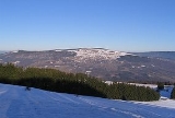
From the plateau there is a superb view over Bischofsheim to the Kreuzberg
Kreuzberg (Rhön)
The Kreuzberg is one of the Rhön Mountains in southern Germany. It is about high and is located in the Bavarian part of the Rhön, in the province of Lower Franconia. The Kreuzberg — also referred to as the "sacred mountain of the Franconians" — is near the town of Bischofsheim an der Rhön in the...
, the Osterburg ruins, the Arnsberg
Arnsberg (Rhön)
Arnsberg is a mountain of Bavaria, Germany....
, the Black Mountains, the Schachen, the Eierhauck
Eierhauckberg
Eierhauckberg is a mountain of Bavaria, Germany....
, the Dammersfeld
Dammersfeldkuppe
At the Dammersfeldkuppe in Bavaria is the second highest mountain after the Wasserkuppe in the Rhön, a low mountain range straddling the states of Bavaria, Hesse and Thuringia in Germany.- Location :...
, the Reesberg, the valley of the Brend and the upper Sinn. In very good conditions the Fichtelgebirge
Fichtelgebirge
The Fichtelgebirge is a mountain range in northeastern Bavaria, Germany. It extends from the valley of the Red Main River to the Czech border, a few foothills spilling over into the Czech Republic. It continues in a northeastern direction as the Ore Mountains, and in a southeastern direction as...
mountain range can be seen.
From the northeastern flank the Heidelstein
Heidelstein
Heidelstein is a mountain of Bavaria, Germany....
is also visible.