
Randolph, Tennessee
Encyclopedia
Randolph is an unincorporated
rural community in Tipton County
, Tennessee
, United States
, located on the banks of the Mississippi River
. Randolph was founded in the 1820s and in 1827, the Randolph Post office
was established. In the 1830s, the town became an early center of river commerce in West Tennessee
. Randolph shipped more cotton
annually than Memphis
until 1840. In 1834, the first pastor
of the Methodist
congregation was appointed. The fortunes of the community began to decline in the late 1840s due to failed railroad
development, an unfavorable mail route and other factors. The first Confederate States Army
fort
in Tennessee was built at Randolph early in the American Civil War
in 1861, a second fortification at Randolph was constructed later that same year. During the Civil War, the town was burned down twice by Union Army
forces.
The settlement is located on the second Chickasaw Bluff
, the landscape is dominated by valley
s carved into the soil as a product of erosion
. The surface soil is composed mostly of silt
loam
, derived from eroded loess
, and is found in different qualities and at different stages of erosion. The stratum
beneath the surface consists of glacial
gravel
. Randolph is situated on the southeastern edge of the New Madrid Seismic Zone
, an area with a high earthquake
risk. Between 1974 and 2004, fourtyfive earthquakes were recorded in a radius of 20 miles (32 km) around the settlement. Located in the humid subtropical climate
zone, the climate is characterized by hot, humid summers and chilly to mild winters.
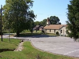
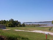
In 2008, Randolph Bluff Historic Park was dedicated. The park is intended to promote the Civil War history of the community and make the unique views of the Mississippi River available to a wider public. As of 2008, Randolph has a population of ca. 200 and consists of about two dozen dwellings. The economy
of the rural community is dominated by agriculture
with no major industries and businesses present. The Girl Scouts Heart of the South operates a camp at Randolph.
began settling the land east of the Mississippi River
that was inhabited by the Chickasaw
Indians for centuries prior to the arrival of Europeans. Chickasaw land in West Tennessee
and southwestern Kentucky
was ceded in the Jackson Purchase
. In 1818, both sides agreed to the transfer by signing the Treaty of Tuscaloosa.
In the early 19th century, the terrain of the Chickasaw Bluffs provided promising locations for a harbor on the Mississippi River for Randolph. In 1820, the area had an estimated population of 54. Early in the 1820s, investors John T. Brown and Robert Bedford were the owners of the land that would form Randolph a few years later. Only 40–50 mi (64.4–80.5 km) north of Memphis
by water, they described the area as "a good landing for Mississippi River flatboats". The Hatchie River
, joining the Mississippi River just north of Randolph, was accessible to steamboats
upriver to Bolivar
. Brown and Bedford chose the site to lay out the plan for Randolph, a promising river town. The Tennessee Encyclopedia of History and Culture gives the date of Randolph's official establishment as 1823. Other reports date the foundation to 1827 or 1828. The settlement is named for John Randolph
(1773–1833), a leader in the United States Congress
from Virginia
.
of Randolph provided for an ideal harbor for steamboats and flatboat
s at all river stages. Randolph became the center of steamboat
commerce in Tennessee. The town was an early rival of Memphis
over commercial superiority on the Mississippi River.
In 1830, Randolph was the most important shipping point in Tennessee. In the mid 1830s, Randolph shipped up to 40,000 bales of cotton on the Mississippi River every year. More cotton was shipped from Randolph than from Memphis until 1840. At the peak of its commercial success, the community was called the "great steamboat depot of West Tennessee
".
By 1829, Randolph had three commission warehouses, six dry goods stores, ten physicians and one tavern
. In 1834, Randolph had a population of approximately 1,000. By that time, the town had four hotel
s, almost fifty businesses, private school
s, and more than ten saloons. In the 1830s, two newspapers were published in Randolph, the Randolph Recorder and the Randolph Whig. In the 1830s, the first bank was founded and a stagecoach
line provided a connection between Randolph and Jackson
twice a week. The commercial success of Randolph can be attributed in part to the use of slave labor, mostly for the cultivation
of cotton
. Corn
, bean
s and pea
s were also cultivated. In the Randolph Recorder during the early 1830s, landowners announced public auctions of slaves or offered rewards for runaway or stolen slaves.
with land owner Ann Grambelling from New York
. Until 1835, the pending lawsuit "prevented the growth of population" in and around Randolph. The residents of the community bought back the land their town was founded on for $8,000 in a settlement.
An unfavorable mail line also had an early and lasting influence on the fortunes of the town. When the mail route was established in 1829, Randolph was put at the end of a branch route of the mail line and received mail only once a week. Failed railroad
development further contributed to the demise of the town; and in 1852, residents of Randolph unsuccessfully tried to move the county seat from Covington
to Randolph. Financial depression and David Crockett
's failed attempt to cut a canal from the Hatchie River
to the Tennessee River
also were problems that had a negative impact on the future of commercial prosperity in Randolph. During the Civil War
, the town was burned down twice, in September 1862 and again in 1865, discouraging many residents from re-building residences and businesses a second time.
was the first Confederate Army
fortification built at Randolph. On January 20, 1861, the Memphis Appeal published a pro-secession
ist proposal to build a fort at Randolph to defend Memphis. In April 1861, Tennessee Governor Isham G. Harris
ordered to establish a camp and complete the fortification at Randolph. About 5,000 troops from Tennessee, Arkansas
and the Confederate Army
were stationed at the location to accomplish the task. By June 1861, fifty cannons were reported to be ready at Fort Wright.
Nathan Bedford Forrest
(1821–77) trained at Fort Wright. Forrest and other future leaders in the Confederate States Army
and the Army of Tennessee
received training at Fort Wright. The fort was Tennessee's first military training camp in which soldiers could gain experience in the construction of fortifications and the setup of artillery batteries. Fort Wright was the forwardmost defensive position on the Mississippi River until July 1861. In 2008, only a powder magazine
is left of Fort Wright.
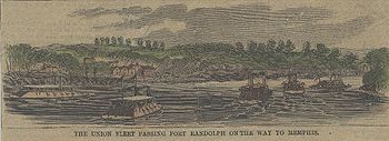
Fort Randolph
, the second Confederate stronghold in the area during the Civil War, was constructed in Fall 1861. The fortification was situated on the Mississippi River bluffs, about 1 miles (1.6 km) southwest of Fort Wright. In a dispatch published by the New York Times
in March 1862, Fort Randolph is described as a "rough and incomplete earthwork (...), more than 100 feet above the river". The position of the fortification allowed a view of the Mississippi River for 6 miles (10 km), both upstream and downstream. In 2008, Fort Randolph is no longer in existence.
 In 1862, Union Army Major General
William T. Sherman
(1820–91) and his troops assumed control of Memphis
and the surrounding areas. While trying to keep the area under Union control, Sherman became "frustrated by the constant guerrilla activity in his sector". Confederate guerrillas
from the Randolph area weakened the Union forces along the Mississippi River.
In September 1862, the Union supply ship Eugene was fired at from Randolph. Sherman ordered to "destroy the place, leaving one house to mark the place". Union Army soldiers burned down Randolph in retaliation for the guerrilla attack. To his superior officer, General Ulysses S. Grant
, Sherman reported that he had "given public notice that a repetition [of guerrilla attacks] will justify any measures of retaliation". Randolph was burned down a second time by federal soldiers in 1865.
 Randolph is located at 35°30′59"N 89°53′19"W. The elevation above sea level is 315 feet (96 m).
The surface soil in the Randolph area is composed mostly of silt
loam
of different qualities and at different stages of erosion
. About 15% of the surface soil consists of "Adler silt loam" with a slope of 0–1%, found in the frequently flooded plains at Randolph. About 20% of the soil is severely eroded "Memphis silt loam" with 12–25% slopes, and ca. 35% of the soil consists of "Memphis silt loam" with 20–40% slopes. Less than 8% consists of moderately eroded "Memphis silt loam" with slopes from 1–5%. The remaining surface soil is composed of other silts, sand
s or clay
s, including "Robinsonville fine sandy loam" (ca. 6%) and "Tunica clay" (ca. 1.5%). Approximately 1.5% of the area is covered by water. The parent material of the "Memphis silt loam" is Pleistocene
loess
. Loess is a fine-grained, slightly coherent
, silt
y, windblown sediment. Eroded loess consists of extremely fine, sandy particles and forms silt in environments that provide sufficient moisture of the soil, usually caused by occasional flooding or precipitation
. Soil derived from eroded loess is sometimes also referred to as loess.
, on the eastern bank of the Mississippi River
in Tipton County
. The four Chickasaw Bluffs are high grounds above the Mississippi River
flood plains
, composed of eroded pre-historic
loess over glacial
gravel
. The Chickasaw Bluffs west of the community, on the banks of the Mississippi River, and flat cotton-fields east of Randolph dominate the rural
landscape surrounding the settlement.
In the last 150 years, the general landscape around Randolph has not changed much. In 1862, the hinterland
of the town is described to be "full of ravines and gorges". Ravine
s and gorges are valley
s or canyon
s carved from the landscape as a product of erosion
, caused by a stream or river or by seasonal precipitation
, funneling water towards less elevated locations of the drainage basin
. The landscape cut into the soil of the Mississippi River bluffs by water erosion for centuries is still present in modern times.
road from Randolph to Jackson
in Madison County, 70 miles (112.7 km) east of Randolph, was established. The antebellum route connected the two towns as well as the villages along the way two times per week. Randolph and Memphis were connected by a direct travel route later in the 1830s. The road was part of a mail line between Jackson and Memphis in Shelby County
on which mail was delivered weekly on horseback. The exact routing of the segment between Randolph and Memphis is unknown. A fragment of the route bearing the former name, about 1000 feet (304.8 m) in length, was in existence until about 2005. The remaining piece of Old Randolph Road was located about 2 miles (3 km) north of the mouth of the Wolf River
and 800 feet (243.8 m) east of the Mississippi River, just south of the mouth of the Loosahatchie River
in Memphis. As of 2010, the remaining fragment of Old Randolph Road is destroyed, the land on which the historic mail route was located is used as an industrial property. A publication dated 1862, reports that Randolph is "approached in the rear by several good roads".
In 2008, Randolph is located near "good roads" as well as it was during the Civil War, with the exception that modern roads in the area are paved for the most part. U.S. Route 51 passes Randolph 5 miles (8 km) in the southeast and Tennessee State Route 59 (TN 59) passes 0.5 miles (804.7 m) southeast of the town. Four roads at county level converge at Randolph, as shown in the table below. A portion of Ballard Slough Road is located in the flood plains, this segment is prone to flooding and unpaved.
. In the 1820s, the Hatchie River
at Randolph was accessible to steamboats
for 60 miles (96.6 km) upriver to Bolivar
in Hardeman County.
The United States Army Corps of Engineers
(USACE) is the federal agency responsible for navigable
waters and flood
protection, among many other peacetime and wartime tasks. From 2005 to 2007, the USACE spent $9,773,662 to ensure the navigation of the Mississippi River at Randolph for boats and barge
s and to provide flood protection for the immediately surrounding areas of the town. Contracts include surveying
and map
ping, engineering and construction, as well as tasks related to conservation and development of the Mississippi River and the river basin at Randolph. Maintenance related projects include dredging of the navigable channel
of the Mississippi River at Randolph to remove sediment
ed sand and mud. Tasks related to conservation include dike
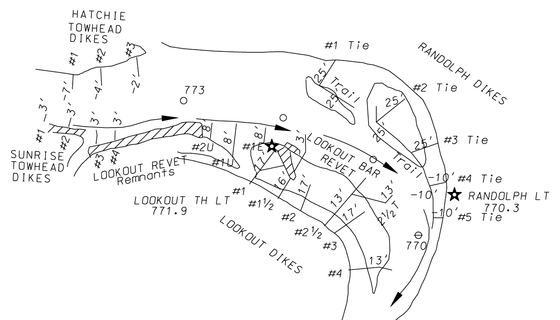
construction to protect low-lying areas at Randolph from flooding and subsequent erosion. The Navigation Bulletin No. 2, issued by the USACE in 2006, describes a stone dike construction at Randolph with an approximate elevation of 25 feet (7.6 m) at river mile 770L.
, the settlement of Randolph is situated in an area with a high earthquake
risk. Between 1974 and 2004, ten earthquakes have been recorded in a radius of 10 miles (16 km) around Randolph. The magnitude of the temblors ranged from 1.5 to 3.2 on the Richter scale
. The epicenter
depth ranged from 3.1 miles (5 km) to 8.2 miles (13.2 km). In the same time period, at a radius of 20 miles (32 km) around Randolph, fourtyfive earthquakes have been reported with magnitudes ranging from 1.0 to 3.2 at a depth between 656 feet (200 m) and 12.1 miles (19.5 km). The highest magnitude earthquake recorded in the area since 1974 occurred on August 19, 1994 — the temblor was measured 3.2 on the Richter scale with an epicenter at coordinates 35.51°N 89.92°W, ca. 2 miles (3 km) west of Randolph, at a depth of 6.6 miles (10.6 km).
On January 16, 2009 at 3:09 p.m.
local time (21:09 UTC
), "a small earthquake shook portions of Tipton County". The earthquake was measured at a magnitude 2.8 on the Richter scale. According to the Center for Earthquake Research and Information (CERI), the epicenter of the temblor was reported to be at coordinates 35.645°N 89.694°W at a depth of 5.3 miles (8.5 km). There were no reports of damage caused by the earthquake. The location of the epicenter was near the first Chickasaw Bluff
, about 2 miles (3 km) east of Fort Pillow State Park
and ca. 8 miles (13 km) northeast of Randolph. Smaller earthquakes along the New Madrid Seismic Zone are not uncommon.
zone. The climate is characterized by hot, humid summers and chilly to mild winters. Significant amounts of precipitation occur in all seasons. At Randolph, July is the warmest month on the average. In 1930, the highest recorded temperature was measured at 108 °F (42.2 °C). January is the coolest month on the average. In 1951, the lowest recorded temperature was measured at -11 °F. Precipitation
peaks in December on the average. The table below displays the average monthly high and low temperatures and precipitation at Randolph.
is the dominant source of income in the area surrounding Randolph, especially the cultivation of cotton
. Corn
, bean
s and pea
s were also cultivated during the last century. After the abolition of slavery
in 1865, sharecropping
was the primary means of income for low income families in the area. Mostly for the cultivation
of cotton
, land would be used by sharecroppers in return for a share of the crop to the landowner. Modern machines such as the cotton picker
have made the manual cultivation
obsolete over time as they took over the work from the hand laborers
.
In 2008, Randolph has a population of ca. 200, and consists of about two dozen dwellings. The economy of the rural community is dominated by agriculture with no major industries and businesses present.
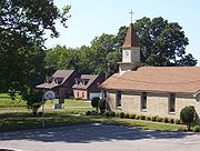 In 1834, Reverend Samuel R. Davidson became the first pastor
at Randolph. He was appointed by the Tennessee Conference of the United Methodist Church. After his appointment as a pastor of the community, a congregation formed around Davidson and built a church at Randolph. The second church at Randolph was built by the congregation in 1883. In 1953, construction of a new church was completed, the building was remodeled in 1975 and serves as a place of worship
for the Methodist congregation of Randolph as of 2008.
The United Methodist Church at Randolph had 78 pastors as of 1983. In 2008, Reverend Thomas M. Yoder and Reverend Ben Rainey are the appointed pastors at the Randolph Methodist community. Randolph United Methodist Church is located at 98 Ballard Slough Road. The worship attendance for the church is reported as 76 members of the congregation on the average.
, dedicated Randolph Bluff Historic Park in a celebration with politician
s, conservationists
, historian
s and community members. The 19 acres (76,890.3 m²) property on the second Chickasaw Bluff was purchased for $378,000. The park is intended to promote the Civil War history of the community and make the unique views of the Mississippi River available to a wider public, additional revenue from tourism is expected for the community. Once Randolph Bluff Historic Park is finished, it will be part of the Mississippi River Corridor Tennessee, a project to "create a scenic byway that connects historic sites along the Mississippi River", the project also promotes economical development and the preservation of land and wildlife in the Tennessee counties bordering the Mississippi River.
, including counties in West Tennessee
, North Mississippi
and Crittenden County, Arkansas
. Girl Scouts Heart of the South operates six camps and one training center in their area of coverage, including a 104 acres (420,873.4 m²) property in Tipton County, "Camp Annemeekee". The scout camp is located on Girl Scout Road south of Randolph.
In 2008, the U.S. ZIP code
for Randolph is 38015 (Burlison, Tennessee
). The telephone area code
is 901 (Memphis metro area
).
Unincorporated area
In law, an unincorporated area is a region of land that is not a part of any municipality.To "incorporate" in this context means to form a municipal corporation, a city, town, or village with its own government. An unincorporated community is usually not subject to or taxed by a municipal government...
rural community in Tipton County
Tipton County, Tennessee
Tipton County is a county located on the western end of the U.S. state of Tennessee. As of 2000, the population was 51,271. Its county seat is Covington. Tipton County is part of the Memphis, TN–MS–AR Metropolitan Statistical Area, centered on Shelby County, which borders Tipton on...
, Tennessee
Tennessee
Tennessee is a U.S. state located in the Southeastern United States. It has a population of 6,346,105, making it the nation's 17th-largest state by population, and covers , making it the 36th-largest by total land area...
, United States
United States
The United States of America is a federal constitutional republic comprising fifty states and a federal district...
, located on the banks of the Mississippi River
Mississippi River
The Mississippi River is the largest river system in North America. Flowing entirely in the United States, this river rises in western Minnesota and meanders slowly southwards for to the Mississippi River Delta at the Gulf of Mexico. With its many tributaries, the Mississippi's watershed drains...
. Randolph was founded in the 1820s and in 1827, the Randolph Post office
Post office
A post office is a facility forming part of a postal system for the posting, receipt, sorting, handling, transmission or delivery of mail.Post offices offer mail-related services such as post office boxes, postage and packaging supplies...
was established. In the 1830s, the town became an early center of river commerce in West Tennessee
West Tennessee
West Tennessee is one of the three Grand Divisions of the State of Tennessee. Of the three, it is the one that is most sharply defined geographically. Its boundaries are the Mississippi River on the west and the Tennessee River on the east...
. Randolph shipped more cotton
Cotton
Cotton is a soft, fluffy staple fiber that grows in a boll, or protective capsule, around the seeds of cotton plants of the genus Gossypium. The fiber is almost pure cellulose. The botanical purpose of cotton fiber is to aid in seed dispersal....
annually than Memphis
Memphis, Tennessee
Memphis is a city in the southwestern corner of the U.S. state of Tennessee, and the county seat of Shelby County. The city is located on the 4th Chickasaw Bluff, south of the confluence of the Wolf and Mississippi rivers....
until 1840. In 1834, the first pastor
Pastor
The word pastor usually refers to an ordained leader of a Christian congregation. When used as an ecclesiastical styling or title, this role may be abbreviated to "Pr." or often "Ps"....
of the Methodist
United Methodist Church
The United Methodist Church is a Methodist Christian denomination which is both mainline Protestant and evangelical. Founded in 1968 by the union of The Methodist Church and the Evangelical United Brethren Church, the UMC traces its roots back to the revival movement of John and Charles Wesley...
congregation was appointed. The fortunes of the community began to decline in the late 1840s due to failed railroad
Rail transport
Rail transport is a means of conveyance of passengers and goods by way of wheeled vehicles running on rail tracks. In contrast to road transport, where vehicles merely run on a prepared surface, rail vehicles are also directionally guided by the tracks they run on...
development, an unfavorable mail route and other factors. The first Confederate States Army
Confederate States Army
The Confederate States Army was the army of the Confederate States of America while the Confederacy existed during the American Civil War. On February 8, 1861, delegates from the seven Deep South states which had already declared their secession from the United States of America adopted the...
fort
Fortification
Fortifications are military constructions and buildings designed for defence in warfare and military bases. Humans have constructed defensive works for many thousands of years, in a variety of increasingly complex designs...
in Tennessee was built at Randolph early in the American Civil War
American Civil War
The American Civil War was a civil war fought in the United States of America. In response to the election of Abraham Lincoln as President of the United States, 11 southern slave states declared their secession from the United States and formed the Confederate States of America ; the other 25...
in 1861, a second fortification at Randolph was constructed later that same year. During the Civil War, the town was burned down twice by Union Army
Union Army
The Union Army was the land force that fought for the Union during the American Civil War. It was also known as the Federal Army, the U.S. Army, the Northern Army and the National Army...
forces.
The settlement is located on the second Chickasaw Bluff
Chickasaw Bluff
The term Chickasaw Bluff refers to high ground rising about above the flood plain between Fulton in Lauderdale County, Tennessee and Memphis in Shelby County, Tennessee. Composed of eroded Pleistocene loess over Pliocene glacial gravel, they are slide prone...
, the landscape is dominated by valley
Valley
In geology, a valley or dale is a depression with predominant extent in one direction. A very deep river valley may be called a canyon or gorge.The terms U-shaped and V-shaped are descriptive terms of geography to characterize the form of valleys...
s carved into the soil as a product of erosion
Erosion
Erosion is when materials are removed from the surface and changed into something else. It only works by hydraulic actions and transport of solids in the natural environment, and leads to the deposition of these materials elsewhere...
. The surface soil is composed mostly of silt
Silt
Silt is granular material of a size somewhere between sand and clay whose mineral origin is quartz and feldspar. Silt may occur as a soil or as suspended sediment in a surface water body...
loam
Loam
Loam is soil composed of sand, silt, and clay in relatively even concentration . Loam soils generally contain more nutrients and humus than sandy soils, have better infiltration and drainage than silty soils, and are easier to till than clay soils...
, derived from eroded loess
Loess
Loess is an aeolian sediment formed by the accumulation of wind-blown silt, typically in the 20–50 micrometre size range, twenty percent or less clay and the balance equal parts sand and silt that are loosely cemented by calcium carbonate...
, and is found in different qualities and at different stages of erosion. The stratum
Stratum
In geology and related fields, a stratum is a layer of sedimentary rock or soil with internally consistent characteristics that distinguish it from other layers...
beneath the surface consists of glacial
Glacier
A glacier is a large persistent body of ice that forms where the accumulation of snow exceeds its ablation over many years, often centuries. At least 0.1 km² in area and 50 m thick, but often much larger, a glacier slowly deforms and flows due to stresses induced by its weight...
gravel
Gravel
Gravel is composed of unconsolidated rock fragments that have a general particle size range and include size classes from granule- to boulder-sized fragments. Gravel can be sub-categorized into granule and cobble...
. Randolph is situated on the southeastern edge of the New Madrid Seismic Zone
New Madrid Seismic Zone
The New Madrid Seismic Zone , sometimes called the New Madrid Fault Line, is a major seismic zone and a prolific source of intraplate earthquakes in the southern and midwestern United States, stretching to the southwest from New Madrid, Missouri.The New Madrid fault system was responsible for the...
, an area with a high earthquake
Earthquake
An earthquake is the result of a sudden release of energy in the Earth's crust that creates seismic waves. The seismicity, seismism or seismic activity of an area refers to the frequency, type and size of earthquakes experienced over a period of time...
risk. Between 1974 and 2004, fourtyfive earthquakes were recorded in a radius of 20 miles (32 km) around the settlement. Located in the humid subtropical climate
Humid subtropical climate
A humid subtropical climate is a climate zone characterized by hot, humid summers and mild to cool winters...
zone, the climate is characterized by hot, humid summers and chilly to mild winters.
In 2008, Randolph Bluff Historic Park was dedicated. The park is intended to promote the Civil War history of the community and make the unique views of the Mississippi River available to a wider public. As of 2008, Randolph has a population of ca. 200 and consists of about two dozen dwellings. The economy
Economy
An economy consists of the economic system of a country or other area; the labor, capital and land resources; and the manufacturing, trade, distribution, and consumption of goods and services of that area...
of the rural community is dominated by agriculture
Agriculture
Agriculture is the cultivation of animals, plants, fungi and other life forms for food, fiber, and other products used to sustain life. Agriculture was the key implement in the rise of sedentary human civilization, whereby farming of domesticated species created food surpluses that nurtured the...
with no major industries and businesses present. The Girl Scouts Heart of the South operates a camp at Randolph.
European settlement
Around 1800, EuropeansEuropean ethnic groups
The ethnic groups in Europe are the various ethnic groups that reside in the nations of Europe. European ethnology is the field of anthropology focusing on Europe....
began settling the land east of the Mississippi River
Mississippi River
The Mississippi River is the largest river system in North America. Flowing entirely in the United States, this river rises in western Minnesota and meanders slowly southwards for to the Mississippi River Delta at the Gulf of Mexico. With its many tributaries, the Mississippi's watershed drains...
that was inhabited by the Chickasaw
Chickasaw
The Chickasaw are Native American people originally from the region that would become the Southeastern United States...
Indians for centuries prior to the arrival of Europeans. Chickasaw land in West Tennessee
West Tennessee
West Tennessee is one of the three Grand Divisions of the State of Tennessee. Of the three, it is the one that is most sharply defined geographically. Its boundaries are the Mississippi River on the west and the Tennessee River on the east...
and southwestern Kentucky
Kentucky
The Commonwealth of Kentucky is a state located in the East Central United States of America. As classified by the United States Census Bureau, Kentucky is a Southern state, more specifically in the East South Central region. Kentucky is one of four U.S. states constituted as a commonwealth...
was ceded in the Jackson Purchase
Jackson Purchase (U.S. historical region)
The Jackson Purchase is a region of western Tennessee and southwestern Kentucky, bounded by the Tennessee River on the east, the Ohio River on the north, and the Mississippi River on the west, that was ceded to the United States by the Chickasaw Peoples in 1818...
. In 1818, both sides agreed to the transfer by signing the Treaty of Tuscaloosa.
In the early 19th century, the terrain of the Chickasaw Bluffs provided promising locations for a harbor on the Mississippi River for Randolph. In 1820, the area had an estimated population of 54. Early in the 1820s, investors John T. Brown and Robert Bedford were the owners of the land that would form Randolph a few years later. Only 40–50 mi (64.4–80.5 km) north of Memphis
Memphis, Tennessee
Memphis is a city in the southwestern corner of the U.S. state of Tennessee, and the county seat of Shelby County. The city is located on the 4th Chickasaw Bluff, south of the confluence of the Wolf and Mississippi rivers....
by water, they described the area as "a good landing for Mississippi River flatboats". The Hatchie River
Hatchie River
The Hatchie River is a stream in northern Mississippi and southwestern Tennessee. It is of considerable geographic, cultural, and historic significance. In large measure this is because it is the only major stream of West Tennessee that has never been impounded, channelized, or otherwise...
, joining the Mississippi River just north of Randolph, was accessible to steamboats
Steamboats of the Mississippi
Steamboats played a major role in the 19th Century development of the Mississippi River and its tributaries by allowing the practical large-scale transport of passengers and freight both up- and down-river. Using steam power, riverboats were developed during that time which could navigate in...
upriver to Bolivar
Bolivar, Tennessee
Bolivar is a city in Hardeman County, Tennessee, in the United States. As of the 2000 census, the city population was 5,802. It is the county seat of Hardeman County. The town was named for South American revolutionary leader Simón Bolívar, but is pronounced to rhyme with the name Oliver. Bolivar...
. Brown and Bedford chose the site to lay out the plan for Randolph, a promising river town. The Tennessee Encyclopedia of History and Culture gives the date of Randolph's official establishment as 1823. Other reports date the foundation to 1827 or 1828. The settlement is named for John Randolph
John Randolph of Roanoke
John Randolph , known as John Randolph of Roanoke, was a planter and a Congressman from Virginia, serving in the House of Representatives , the Senate , and also as Minister to Russia...
(1773–1833), a leader in the United States Congress
United States Congress
The United States Congress is the bicameral legislature of the federal government of the United States, consisting of the Senate and the House of Representatives. The Congress meets in the United States Capitol in Washington, D.C....
from Virginia
Virginia
The Commonwealth of Virginia , is a U.S. state on the Atlantic Coast of the Southern United States. Virginia is nicknamed the "Old Dominion" and sometimes the "Mother of Presidents" after the eight U.S. presidents born there...
.
Success
Located on the banks of the Mississippi River, the topographyTopography
Topography is the study of Earth's surface shape and features or those ofplanets, moons, and asteroids...
of Randolph provided for an ideal harbor for steamboats and flatboat
Flatboat
Fil1800flatboat.jpgA flatboat is a rectangular flat-bottomed boat with Fil1800flatboat.jpgA flatboat is a rectangular flat-bottomed boat with Fil1800flatboat.jpgA flatboat is a rectangular flat-bottomed boat with (mostlyNOTE: "(parenthesized)" wordings in the quote below are notes added to...
s at all river stages. Randolph became the center of steamboat
Steamboats of the Mississippi
Steamboats played a major role in the 19th Century development of the Mississippi River and its tributaries by allowing the practical large-scale transport of passengers and freight both up- and down-river. Using steam power, riverboats were developed during that time which could navigate in...
commerce in Tennessee. The town was an early rival of Memphis
Memphis, Tennessee
Memphis is a city in the southwestern corner of the U.S. state of Tennessee, and the county seat of Shelby County. The city is located on the 4th Chickasaw Bluff, south of the confluence of the Wolf and Mississippi rivers....
over commercial superiority on the Mississippi River.
In 1830, Randolph was the most important shipping point in Tennessee. In the mid 1830s, Randolph shipped up to 40,000 bales of cotton on the Mississippi River every year. More cotton was shipped from Randolph than from Memphis until 1840. At the peak of its commercial success, the community was called the "great steamboat depot of West Tennessee
West Tennessee
West Tennessee is one of the three Grand Divisions of the State of Tennessee. Of the three, it is the one that is most sharply defined geographically. Its boundaries are the Mississippi River on the west and the Tennessee River on the east...
".
By 1829, Randolph had three commission warehouses, six dry goods stores, ten physicians and one tavern
Tavern
A tavern is a place of business where people gather to drink alcoholic beverages and be served food, and in some cases, where travelers receive lodging....
. In 1834, Randolph had a population of approximately 1,000. By that time, the town had four hotel
Hotel
A hotel is an establishment that provides paid lodging on a short-term basis. The provision of basic accommodation, in times past, consisting only of a room with a bed, a cupboard, a small table and a washstand has largely been replaced by rooms with modern facilities, including en-suite bathrooms...
s, almost fifty businesses, private school
School
A school is an institution designed for the teaching of students under the direction of teachers. Most countries have systems of formal education, which is commonly compulsory. In these systems, students progress through a series of schools...
s, and more than ten saloons. In the 1830s, two newspapers were published in Randolph, the Randolph Recorder and the Randolph Whig. In the 1830s, the first bank was founded and a stagecoach
Stagecoach
A stagecoach is a type of covered wagon for passengers and goods, strongly sprung and drawn by four horses, usually four-in-hand. Widely used before the introduction of railway transport, it made regular trips between stages or stations, which were places of rest provided for stagecoach travelers...
line provided a connection between Randolph and Jackson
Jackson, Tennessee
Jackson is a city in Madison County, Tennessee, United States. The total population was 65,211 at the 2010 census. Jackson is the primary city of the Jackson, Tennessee metropolitan area, which is included in the Jackson-Humboldt, Tennessee Combined Statistical Area...
twice a week. The commercial success of Randolph can be attributed in part to the use of slave labor, mostly for the cultivation
Tillage
Tillage is the agricultural preparation of the soil by mechanical agitation of various types, such as digging, stirring, and overturning. Examples of human-powered tilling methods using hand tools include shovelling, picking, mattock work, hoeing, and raking...
of cotton
Cotton
Cotton is a soft, fluffy staple fiber that grows in a boll, or protective capsule, around the seeds of cotton plants of the genus Gossypium. The fiber is almost pure cellulose. The botanical purpose of cotton fiber is to aid in seed dispersal....
. Corn
Maize
Maize known in many English-speaking countries as corn or mielie/mealie, is a grain domesticated by indigenous peoples in Mesoamerica in prehistoric times. The leafy stalk produces ears which contain seeds called kernels. Though technically a grain, maize kernels are used in cooking as a vegetable...
, bean
Bean
Bean is a common name for large plant seeds of several genera of the family Fabaceae used for human food or animal feed....
s and pea
Pea
A pea is most commonly the small spherical seed or the seed-pod of the pod fruit Pisum sativum. Each pod contains several peas. Peapods are botanically a fruit, since they contain seeds developed from the ovary of a flower. However, peas are considered to be a vegetable in cooking...
s were also cultivated. In the Randolph Recorder during the early 1830s, landowners announced public auctions of slaves or offered rewards for runaway or stolen slaves.
Decline
The fortunes of Randolph declined in the later 1840s and the 1850s due to many factors, starting shortly after the establishment of the town. Five years after the settlement was founded, a dispute over the ownership of the land the town was established on, arose over a faulty land titleLand registration
Land registration generally describes systems by which matters concerning ownership, possession or other rights in land can be recorded to provide evidence of title, facilitate transactions and to prevent unlawful disposal...
with land owner Ann Grambelling from New York
New York
New York is a state in the Northeastern region of the United States. It is the nation's third most populous state. New York is bordered by New Jersey and Pennsylvania to the south, and by Connecticut, Massachusetts and Vermont to the east...
. Until 1835, the pending lawsuit "prevented the growth of population" in and around Randolph. The residents of the community bought back the land their town was founded on for $8,000 in a settlement.
An unfavorable mail line also had an early and lasting influence on the fortunes of the town. When the mail route was established in 1829, Randolph was put at the end of a branch route of the mail line and received mail only once a week. Failed railroad
Rail transport
Rail transport is a means of conveyance of passengers and goods by way of wheeled vehicles running on rail tracks. In contrast to road transport, where vehicles merely run on a prepared surface, rail vehicles are also directionally guided by the tracks they run on...
development further contributed to the demise of the town; and in 1852, residents of Randolph unsuccessfully tried to move the county seat from Covington
Covington, Tennessee
Covington is a city in central Tipton County in the State of Tennessee. Covington is the largest city and county seat of, Tipton County. Covington is located in one of just five counties of West Tennessee that are located along the Mississippi River, thus it is in extreme western Tennessee.This...
to Randolph. Financial depression and David Crockett
Davy Crockett
David "Davy" Crockett was a celebrated 19th century American folk hero, frontiersman, soldier and politician. He is commonly referred to in popular culture by the epithet "King of the Wild Frontier". He represented Tennessee in the U.S...
's failed attempt to cut a canal from the Hatchie River
Hatchie River
The Hatchie River is a stream in northern Mississippi and southwestern Tennessee. It is of considerable geographic, cultural, and historic significance. In large measure this is because it is the only major stream of West Tennessee that has never been impounded, channelized, or otherwise...
to the Tennessee River
Tennessee River
The Tennessee River is the largest tributary of the Ohio River. It is approximately 652 miles long and is located in the southeastern United States in the Tennessee Valley. The river was once popularly known as the Cherokee River, among other names...
also were problems that had a negative impact on the future of commercial prosperity in Randolph. During the Civil War
American Civil War
The American Civil War was a civil war fought in the United States of America. In response to the election of Abraham Lincoln as President of the United States, 11 southern slave states declared their secession from the United States and formed the Confederate States of America ; the other 25...
, the town was burned down twice, in September 1862 and again in 1865, discouraging many residents from re-building residences and businesses a second time.
Fortifications
Fort WrightFort Wright (Tennessee)
Fort Wright was constructed in 1861 and located on the second Chickasaw Bluff at Randolph, Tipton County, Tennessee. Fort Wright was a Civil War fortification and the first military training facility of the Confederate Army in Tennessee.-History:...
was the first Confederate Army
Confederate States Army
The Confederate States Army was the army of the Confederate States of America while the Confederacy existed during the American Civil War. On February 8, 1861, delegates from the seven Deep South states which had already declared their secession from the United States of America adopted the...
fortification built at Randolph. On January 20, 1861, the Memphis Appeal published a pro-secession
Secession
Secession is the act of withdrawing from an organization, union, or especially a political entity. Threats of secession also can be a strategy for achieving more limited goals.-Secession theory:...
ist proposal to build a fort at Randolph to defend Memphis. In April 1861, Tennessee Governor Isham G. Harris
Isham G. Harris
Isham Green Harris was an American politician. He served as Governor of Tennessee from 1857 to 1862 and as a U.S. Senator from 1877 until his death....
ordered to establish a camp and complete the fortification at Randolph. About 5,000 troops from Tennessee, Arkansas
Arkansas
Arkansas is a state located in the southern region of the United States. Its name is an Algonquian name of the Quapaw Indians. Arkansas shares borders with six states , and its eastern border is largely defined by the Mississippi River...
and the Confederate Army
Confederate States Army
The Confederate States Army was the army of the Confederate States of America while the Confederacy existed during the American Civil War. On February 8, 1861, delegates from the seven Deep South states which had already declared their secession from the United States of America adopted the...
were stationed at the location to accomplish the task. By June 1861, fifty cannons were reported to be ready at Fort Wright.
Nathan Bedford Forrest
Nathan Bedford Forrest
Nathan Bedford Forrest was a lieutenant general in the Confederate Army during the American Civil War. He is remembered both as a self-educated, innovative cavalry leader during the war and as a leading southern advocate in the postwar years...
(1821–77) trained at Fort Wright. Forrest and other future leaders in the Confederate States Army
Confederate States Army
The Confederate States Army was the army of the Confederate States of America while the Confederacy existed during the American Civil War. On February 8, 1861, delegates from the seven Deep South states which had already declared their secession from the United States of America adopted the...
and the Army of Tennessee
Army of Tennessee
The Army of Tennessee was the principal Confederate army operating between the Appalachian Mountains and the Mississippi River during the American Civil War. It was formed in late 1862 and fought until the end of the war in 1865, participating in most of the significant battles in the Western Theater...
received training at Fort Wright. The fort was Tennessee's first military training camp in which soldiers could gain experience in the construction of fortifications and the setup of artillery batteries. Fort Wright was the forwardmost defensive position on the Mississippi River until July 1861. In 2008, only a powder magazine
Magazine (artillery)
Magazine is the name for an item or place within which ammunition is stored. It is taken from the Arabic word "makahazin" meaning "warehouse".-Ammunition storage areas:...
is left of Fort Wright.
Fort Randolph
Fort Randolph (Tennessee)
Fort Randolph was a Confederate Army fortification built in 1861 during the Civil War. Fort Randolph was located on the second Chickasaw Bluff at Randolph, Tipton County, Tennessee.-History:...
, the second Confederate stronghold in the area during the Civil War, was constructed in Fall 1861. The fortification was situated on the Mississippi River bluffs, about 1 miles (1.6 km) southwest of Fort Wright. In a dispatch published by the New York Times
The New York Times
The New York Times is an American daily newspaper founded and continuously published in New York City since 1851. The New York Times has won 106 Pulitzer Prizes, the most of any news organization...
in March 1862, Fort Randolph is described as a "rough and incomplete earthwork (...), more than 100 feet above the river". The position of the fortification allowed a view of the Mississippi River for 6 miles (10 km), both upstream and downstream. In 2008, Fort Randolph is no longer in existence.
Destruction
Major General
Major general or major-general is a military rank used in many countries. It is derived from the older rank of sergeant major general. A major general is a high-ranking officer, normally subordinate to the rank of lieutenant general and senior to the ranks of brigadier and brigadier general...
William T. Sherman
William Tecumseh Sherman
William Tecumseh Sherman was an American soldier, businessman, educator and author. He served as a General in the Union Army during the American Civil War , for which he received recognition for his outstanding command of military strategy as well as criticism for the harshness of the "scorched...
(1820–91) and his troops assumed control of Memphis
Memphis, Tennessee
Memphis is a city in the southwestern corner of the U.S. state of Tennessee, and the county seat of Shelby County. The city is located on the 4th Chickasaw Bluff, south of the confluence of the Wolf and Mississippi rivers....
and the surrounding areas. While trying to keep the area under Union control, Sherman became "frustrated by the constant guerrilla activity in his sector". Confederate guerrillas
Guerrilla warfare
Guerrilla warfare is a form of irregular warfare and refers to conflicts in which a small group of combatants including, but not limited to, armed civilians use military tactics, such as ambushes, sabotage, raids, the element of surprise, and extraordinary mobility to harass a larger and...
from the Randolph area weakened the Union forces along the Mississippi River.
In September 1862, the Union supply ship Eugene was fired at from Randolph. Sherman ordered to "destroy the place, leaving one house to mark the place". Union Army soldiers burned down Randolph in retaliation for the guerrilla attack. To his superior officer, General Ulysses S. Grant
Ulysses S. Grant
Ulysses S. Grant was the 18th President of the United States as well as military commander during the Civil War and post-war Reconstruction periods. Under Grant's command, the Union Army defeated the Confederate military and ended the Confederate States of America...
, Sherman reported that he had "given public notice that a repetition [of guerrilla attacks] will justify any measures of retaliation". Randolph was burned down a second time by federal soldiers in 1865.
Geography
The surface soil in the Randolph area is composed mostly of silt
Silt
Silt is granular material of a size somewhere between sand and clay whose mineral origin is quartz and feldspar. Silt may occur as a soil or as suspended sediment in a surface water body...
loam
Loam
Loam is soil composed of sand, silt, and clay in relatively even concentration . Loam soils generally contain more nutrients and humus than sandy soils, have better infiltration and drainage than silty soils, and are easier to till than clay soils...
of different qualities and at different stages of erosion
Erosion
Erosion is when materials are removed from the surface and changed into something else. It only works by hydraulic actions and transport of solids in the natural environment, and leads to the deposition of these materials elsewhere...
. About 15% of the surface soil consists of "Adler silt loam" with a slope of 0–1%, found in the frequently flooded plains at Randolph. About 20% of the soil is severely eroded "Memphis silt loam" with 12–25% slopes, and ca. 35% of the soil consists of "Memphis silt loam" with 20–40% slopes. Less than 8% consists of moderately eroded "Memphis silt loam" with slopes from 1–5%. The remaining surface soil is composed of other silts, sand
Sand
Sand is a naturally occurring granular material composed of finely divided rock and mineral particles.The composition of sand is highly variable, depending on the local rock sources and conditions, but the most common constituent of sand in inland continental settings and non-tropical coastal...
s or clay
Clay
Clay is a general term including many combinations of one or more clay minerals with traces of metal oxides and organic matter. Geologic clay deposits are mostly composed of phyllosilicate minerals containing variable amounts of water trapped in the mineral structure.- Formation :Clay minerals...
s, including "Robinsonville fine sandy loam" (ca. 6%) and "Tunica clay" (ca. 1.5%). Approximately 1.5% of the area is covered by water. The parent material of the "Memphis silt loam" is Pleistocene
Pleistocene
The Pleistocene is the epoch from 2,588,000 to 11,700 years BP that spans the world's recent period of repeated glaciations. The name pleistocene is derived from the Greek and ....
loess
Loess
Loess is an aeolian sediment formed by the accumulation of wind-blown silt, typically in the 20–50 micrometre size range, twenty percent or less clay and the balance equal parts sand and silt that are loosely cemented by calcium carbonate...
. Loess is a fine-grained, slightly coherent
Cohesion (chemistry)
Cohesion or cohesive attraction or cohesive force is the action or property of like molecules sticking together, being mutually attractive...
, silt
Silt
Silt is granular material of a size somewhere between sand and clay whose mineral origin is quartz and feldspar. Silt may occur as a soil or as suspended sediment in a surface water body...
y, windblown sediment. Eroded loess consists of extremely fine, sandy particles and forms silt in environments that provide sufficient moisture of the soil, usually caused by occasional flooding or precipitation
Precipitation (meteorology)
In meteorology, precipitation In meteorology, precipitation In meteorology, precipitation (also known as one of the classes of hydrometeors, which are atmospheric water phenomena is any product of the condensation of atmospheric water vapor that falls under gravity. The main forms of precipitation...
. Soil derived from eroded loess is sometimes also referred to as loess.
Landscape
The settlement of Randolph is situated on top of the second Chickasaw BluffChickasaw Bluff
The term Chickasaw Bluff refers to high ground rising about above the flood plain between Fulton in Lauderdale County, Tennessee and Memphis in Shelby County, Tennessee. Composed of eroded Pleistocene loess over Pliocene glacial gravel, they are slide prone...
, on the eastern bank of the Mississippi River
Mississippi River
The Mississippi River is the largest river system in North America. Flowing entirely in the United States, this river rises in western Minnesota and meanders slowly southwards for to the Mississippi River Delta at the Gulf of Mexico. With its many tributaries, the Mississippi's watershed drains...
in Tipton County
Tipton County, Tennessee
Tipton County is a county located on the western end of the U.S. state of Tennessee. As of 2000, the population was 51,271. Its county seat is Covington. Tipton County is part of the Memphis, TN–MS–AR Metropolitan Statistical Area, centered on Shelby County, which borders Tipton on...
. The four Chickasaw Bluffs are high grounds above the Mississippi River
Mississippi River
The Mississippi River is the largest river system in North America. Flowing entirely in the United States, this river rises in western Minnesota and meanders slowly southwards for to the Mississippi River Delta at the Gulf of Mexico. With its many tributaries, the Mississippi's watershed drains...
flood plains
Floodplain
A floodplain, or flood plain, is a flat or nearly flat land adjacent a stream or river that stretches from the banks of its channel to the base of the enclosing valley walls and experiences flooding during periods of high discharge...
, composed of eroded pre-historic
Prehistory
Prehistory is the span of time before recorded history. Prehistory can refer to the period of human existence before the availability of those written records with which recorded history begins. More broadly, it refers to all the time preceding human existence and the invention of writing...
loess over glacial
Glacier
A glacier is a large persistent body of ice that forms where the accumulation of snow exceeds its ablation over many years, often centuries. At least 0.1 km² in area and 50 m thick, but often much larger, a glacier slowly deforms and flows due to stresses induced by its weight...
gravel
Gravel
Gravel is composed of unconsolidated rock fragments that have a general particle size range and include size classes from granule- to boulder-sized fragments. Gravel can be sub-categorized into granule and cobble...
. The Chickasaw Bluffs west of the community, on the banks of the Mississippi River, and flat cotton-fields east of Randolph dominate the rural
Rural
Rural areas or the country or countryside are areas that are not urbanized, though when large areas are described, country towns and smaller cities will be included. They have a low population density, and typically much of the land is devoted to agriculture...
landscape surrounding the settlement.
In the last 150 years, the general landscape around Randolph has not changed much. In 1862, the hinterland
Hinterland
The hinterland is the land or district behind a coast or the shoreline of a river. Specifically, by the doctrine of the hinterland, the word is applied to the inland region lying behind a port, claimed by the state that owns the coast. The area from which products are delivered to a port for...
of the town is described to be "full of ravines and gorges". Ravine
Ravine
A ravine is a landform narrower than a canyon and is often the product of streamcutting erosion. Ravines are typically classified as larger in scale than gullies, although smaller than valleys. A ravine is generally a fluvial slope landform of relatively steep sides, on the order of twenty to...
s and gorges are valley
Valley
In geology, a valley or dale is a depression with predominant extent in one direction. A very deep river valley may be called a canyon or gorge.The terms U-shaped and V-shaped are descriptive terms of geography to characterize the form of valleys...
s or canyon
Canyon
A canyon or gorge is a deep ravine between cliffs often carved from the landscape by a river. Rivers have a natural tendency to reach a baseline elevation, which is the same elevation as the body of water it will eventually drain into. This forms a canyon. Most canyons were formed by a process of...
s carved from the landscape as a product of erosion
Erosion
Erosion is when materials are removed from the surface and changed into something else. It only works by hydraulic actions and transport of solids in the natural environment, and leads to the deposition of these materials elsewhere...
, caused by a stream or river or by seasonal precipitation
Precipitation (meteorology)
In meteorology, precipitation In meteorology, precipitation In meteorology, precipitation (also known as one of the classes of hydrometeors, which are atmospheric water phenomena is any product of the condensation of atmospheric water vapor that falls under gravity. The main forms of precipitation...
, funneling water towards less elevated locations of the drainage basin
Drainage basin
A drainage basin is an extent or an area of land where surface water from rain and melting snow or ice converges to a single point, usually the exit of the basin, where the waters join another waterbody, such as a river, lake, reservoir, estuary, wetland, sea, or ocean...
. The landscape cut into the soil of the Mississippi River bluffs by water erosion for centuries is still present in modern times.
Roads
In 1833, a stagecoachStagecoach
A stagecoach is a type of covered wagon for passengers and goods, strongly sprung and drawn by four horses, usually four-in-hand. Widely used before the introduction of railway transport, it made regular trips between stages or stations, which were places of rest provided for stagecoach travelers...
road from Randolph to Jackson
Jackson, Tennessee
Jackson is a city in Madison County, Tennessee, United States. The total population was 65,211 at the 2010 census. Jackson is the primary city of the Jackson, Tennessee metropolitan area, which is included in the Jackson-Humboldt, Tennessee Combined Statistical Area...
in Madison County, 70 miles (112.7 km) east of Randolph, was established. The antebellum route connected the two towns as well as the villages along the way two times per week. Randolph and Memphis were connected by a direct travel route later in the 1830s. The road was part of a mail line between Jackson and Memphis in Shelby County
Shelby County, Tennessee
Shelby County is a county located in the U.S. state of Tennessee. It is the state's largest both in terms of population and geographic area, with a population of 927,644 at the 2010 census...
on which mail was delivered weekly on horseback. The exact routing of the segment between Randolph and Memphis is unknown. A fragment of the route bearing the former name, about 1000 feet (304.8 m) in length, was in existence until about 2005. The remaining piece of Old Randolph Road was located about 2 miles (3 km) north of the mouth of the Wolf River
Wolf River (Tennessee)
The Wolf River is a alluvial stream in western Tennessee and northern Mississippi, whose confluence with the Mississippi River was the site of various Chickasaw, French, Spanish and American communities and forts that eventually became Memphis, Tennessee....
and 800 feet (243.8 m) east of the Mississippi River, just south of the mouth of the Loosahatchie River
Loosahatchie River
The Loosahatchie River is a stream in southwestern Tennessee. Except for a few miles near its head, its mouth, and near the middle of its length, it has been entirely channelized, as have its major tributaries, for agriculture purposes...
in Memphis. As of 2010, the remaining fragment of Old Randolph Road is destroyed, the land on which the historic mail route was located is used as an industrial property. A publication dated 1862, reports that Randolph is "approached in the rear by several good roads".
In 2008, Randolph is located near "good roads" as well as it was during the Civil War, with the exception that modern roads in the area are paved for the most part. U.S. Route 51 passes Randolph 5 miles (8 km) in the southeast and Tennessee State Route 59 (TN 59) passes 0.5 miles (804.7 m) southeast of the town. Four roads at county level converge at Randolph, as shown in the table below. A portion of Ballard Slough Road is located in the flood plains, this segment is prone to flooding and unpaved.
| County roads at Randolph connect to ... | Direction | Road name | Surface |
|---|---|---|---|
| Jamestown below the bluff | North | Ballard Slough Rd | partially paved |
| Jamestown on top of the bluff | Northeast | Randolph Rd | fully paved |
| Tennessee State Route 59 (TN 59) | Southeast | Randolph Rd | fully paved |
| TN 59, continues to Drummonds and Dixonville | Southwest | Needham Rd | fully paved |
Waterways
Randolph is located on the eastern bank of the Mississippi River, just south of the lower mouth of the Hatchie RiverHatchie River
The Hatchie River is a stream in northern Mississippi and southwestern Tennessee. It is of considerable geographic, cultural, and historic significance. In large measure this is because it is the only major stream of West Tennessee that has never been impounded, channelized, or otherwise...
. In the 1820s, the Hatchie River
Hatchie River
The Hatchie River is a stream in northern Mississippi and southwestern Tennessee. It is of considerable geographic, cultural, and historic significance. In large measure this is because it is the only major stream of West Tennessee that has never been impounded, channelized, or otherwise...
at Randolph was accessible to steamboats
Steamboats of the Mississippi
Steamboats played a major role in the 19th Century development of the Mississippi River and its tributaries by allowing the practical large-scale transport of passengers and freight both up- and down-river. Using steam power, riverboats were developed during that time which could navigate in...
for 60 miles (96.6 km) upriver to Bolivar
Bolivar, Tennessee
Bolivar is a city in Hardeman County, Tennessee, in the United States. As of the 2000 census, the city population was 5,802. It is the county seat of Hardeman County. The town was named for South American revolutionary leader Simón Bolívar, but is pronounced to rhyme with the name Oliver. Bolivar...
in Hardeman County.
The United States Army Corps of Engineers
United States Army Corps of Engineers
The United States Army Corps of Engineers is a federal agency and a major Army command made up of some 38,000 civilian and military personnel, making it the world's largest public engineering, design and construction management agency...
(USACE) is the federal agency responsible for navigable
Navigation
Navigation is the process of monitoring and controlling the movement of a craft or vehicle from one place to another. It is also the term of art used for the specialized knowledge used by navigators to perform navigation tasks...
waters and flood
Flood
A flood is an overflow of an expanse of water that submerges land. The EU Floods directive defines a flood as a temporary covering by water of land not normally covered by water...
protection, among many other peacetime and wartime tasks. From 2005 to 2007, the USACE spent $9,773,662 to ensure the navigation of the Mississippi River at Randolph for boats and barge
Barge
A barge is a flat-bottomed boat, built mainly for river and canal transport of heavy goods. Some barges are not self-propelled and need to be towed by tugboats or pushed by towboats...
s and to provide flood protection for the immediately surrounding areas of the town. Contracts include surveying
Surveying
See Also: Public Land Survey SystemSurveying or land surveying is the technique, profession, and science of accurately determining the terrestrial or three-dimensional position of points and the distances and angles between them...
and map
Map
A map is a visual representation of an area—a symbolic depiction highlighting relationships between elements of that space such as objects, regions, and themes....
ping, engineering and construction, as well as tasks related to conservation and development of the Mississippi River and the river basin at Randolph. Maintenance related projects include dredging of the navigable channel
Channel (geography)
In physical geography, a channel is the physical confine of a river, slough or ocean strait consisting of a bed and banks.A channel is also the natural or human-made deeper course through a reef, sand bar, bay, or any shallow body of water...
of the Mississippi River at Randolph to remove sediment
Sediment
Sediment is naturally occurring material that is broken down by processes of weathering and erosion, and is subsequently transported by the action of fluids such as wind, water, or ice, and/or by the force of gravity acting on the particle itself....
ed sand and mud. Tasks related to conservation include dike
Levee
A levee, levée, dike , embankment, floodbank or stopbank is an elongated naturally occurring ridge or artificially constructed fill or wall, which regulates water levels...
construction to protect low-lying areas at Randolph from flooding and subsequent erosion. The Navigation Bulletin No. 2, issued by the USACE in 2006, describes a stone dike construction at Randolph with an approximate elevation of 25 feet (7.6 m) at river mile 770L.
Earthquakes
Located on the southeastern edge of the New Madrid Seismic ZoneNew Madrid Seismic Zone
The New Madrid Seismic Zone , sometimes called the New Madrid Fault Line, is a major seismic zone and a prolific source of intraplate earthquakes in the southern and midwestern United States, stretching to the southwest from New Madrid, Missouri.The New Madrid fault system was responsible for the...
, the settlement of Randolph is situated in an area with a high earthquake
Earthquake
An earthquake is the result of a sudden release of energy in the Earth's crust that creates seismic waves. The seismicity, seismism or seismic activity of an area refers to the frequency, type and size of earthquakes experienced over a period of time...
risk. Between 1974 and 2004, ten earthquakes have been recorded in a radius of 10 miles (16 km) around Randolph. The magnitude of the temblors ranged from 1.5 to 3.2 on the Richter scale
Richter magnitude scale
The expression Richter magnitude scale refers to a number of ways to assign a single number to quantify the energy contained in an earthquake....
. The epicenter
Epicenter
The epicenter or epicentre is the point on the Earth's surface that is directly above the hypocenter or focus, the point where an earthquake or underground explosion originates...
depth ranged from 3.1 miles (5 km) to 8.2 miles (13.2 km). In the same time period, at a radius of 20 miles (32 km) around Randolph, fourtyfive earthquakes have been reported with magnitudes ranging from 1.0 to 3.2 at a depth between 656 feet (200 m) and 12.1 miles (19.5 km). The highest magnitude earthquake recorded in the area since 1974 occurred on August 19, 1994 — the temblor was measured 3.2 on the Richter scale with an epicenter at coordinates 35.51°N 89.92°W, ca. 2 miles (3 km) west of Randolph, at a depth of 6.6 miles (10.6 km).
On January 16, 2009 at 3:09 p.m.
12-hour clock
The 12-hour clock is a time conversion convention in which the 24 hours of the day are divided into two periods called ante meridiem and post meridiem...
local time (21:09 UTC
Coordinated Universal Time
Coordinated Universal Time is the primary time standard by which the world regulates clocks and time. It is one of several closely related successors to Greenwich Mean Time. Computer servers, online services and other entities that rely on having a universally accepted time use UTC for that purpose...
), "a small earthquake shook portions of Tipton County". The earthquake was measured at a magnitude 2.8 on the Richter scale. According to the Center for Earthquake Research and Information (CERI), the epicenter of the temblor was reported to be at coordinates 35.645°N 89.694°W at a depth of 5.3 miles (8.5 km). There were no reports of damage caused by the earthquake. The location of the epicenter was near the first Chickasaw Bluff
Chickasaw Bluff
The term Chickasaw Bluff refers to high ground rising about above the flood plain between Fulton in Lauderdale County, Tennessee and Memphis in Shelby County, Tennessee. Composed of eroded Pleistocene loess over Pliocene glacial gravel, they are slide prone...
, about 2 miles (3 km) east of Fort Pillow State Park
Fort Pillow State Park
Fort Pillow State Park is a state park in western Tennessee that preserves the American Civil War site of the Battle of Fort Pillow. The 1,642 acre Fort Pillow, located in Lauderdale County on the Chickasaw Bluffs overlooking the Mississippi River, is rich in both historic and archaeological...
and ca. 8 miles (13 km) northeast of Randolph. Smaller earthquakes along the New Madrid Seismic Zone are not uncommon.
Climate
Randolph is located in a humid subtropical climateHumid subtropical climate
A humid subtropical climate is a climate zone characterized by hot, humid summers and mild to cool winters...
zone. The climate is characterized by hot, humid summers and chilly to mild winters. Significant amounts of precipitation occur in all seasons. At Randolph, July is the warmest month on the average. In 1930, the highest recorded temperature was measured at 108 °F (42.2 °C). January is the coolest month on the average. In 1951, the lowest recorded temperature was measured at -11 °F. Precipitation
Precipitation (meteorology)
In meteorology, precipitation In meteorology, precipitation In meteorology, precipitation (also known as one of the classes of hydrometeors, which are atmospheric water phenomena is any product of the condensation of atmospheric water vapor that falls under gravity. The main forms of precipitation...
peaks in December on the average. The table below displays the average monthly high and low temperatures and precipitation at Randolph.
Economy
AgricultureAgriculture
Agriculture is the cultivation of animals, plants, fungi and other life forms for food, fiber, and other products used to sustain life. Agriculture was the key implement in the rise of sedentary human civilization, whereby farming of domesticated species created food surpluses that nurtured the...
is the dominant source of income in the area surrounding Randolph, especially the cultivation of cotton
Cotton
Cotton is a soft, fluffy staple fiber that grows in a boll, or protective capsule, around the seeds of cotton plants of the genus Gossypium. The fiber is almost pure cellulose. The botanical purpose of cotton fiber is to aid in seed dispersal....
. Corn
Maize
Maize known in many English-speaking countries as corn or mielie/mealie, is a grain domesticated by indigenous peoples in Mesoamerica in prehistoric times. The leafy stalk produces ears which contain seeds called kernels. Though technically a grain, maize kernels are used in cooking as a vegetable...
, bean
Bean
Bean is a common name for large plant seeds of several genera of the family Fabaceae used for human food or animal feed....
s and pea
Pea
A pea is most commonly the small spherical seed or the seed-pod of the pod fruit Pisum sativum. Each pod contains several peas. Peapods are botanically a fruit, since they contain seeds developed from the ovary of a flower. However, peas are considered to be a vegetable in cooking...
s were also cultivated during the last century. After the abolition of slavery
Abolitionism
Abolitionism is a movement to end slavery.In western Europe and the Americas abolitionism was a movement to end the slave trade and set slaves free. At the behest of Dominican priest Bartolomé de las Casas who was shocked at the treatment of natives in the New World, Spain enacted the first...
in 1865, sharecropping
Sharecropping
Sharecropping is a system of agriculture in which a landowner allows a tenant to use the land in return for a share of the crop produced on the land . This should not be confused with a crop fixed rent contract, in which a landowner allows a tenant to use the land in return for a fixed amount of...
was the primary means of income for low income families in the area. Mostly for the cultivation
Tillage
Tillage is the agricultural preparation of the soil by mechanical agitation of various types, such as digging, stirring, and overturning. Examples of human-powered tilling methods using hand tools include shovelling, picking, mattock work, hoeing, and raking...
of cotton
Cotton
Cotton is a soft, fluffy staple fiber that grows in a boll, or protective capsule, around the seeds of cotton plants of the genus Gossypium. The fiber is almost pure cellulose. The botanical purpose of cotton fiber is to aid in seed dispersal....
, land would be used by sharecroppers in return for a share of the crop to the landowner. Modern machines such as the cotton picker
Cotton picker
The mechanical cotton picker is a machine that automates cotton harvesting in a way that reduces harvest time and maximizes efficiency.-History:...
have made the manual cultivation
Tillage
Tillage is the agricultural preparation of the soil by mechanical agitation of various types, such as digging, stirring, and overturning. Examples of human-powered tilling methods using hand tools include shovelling, picking, mattock work, hoeing, and raking...
obsolete over time as they took over the work from the hand laborers
Manual labour
Manual labour , manual or manual work is physical work done by people, most especially in contrast to that done by machines, and also to that done by working animals...
.
In 2008, Randolph has a population of ca. 200, and consists of about two dozen dwellings. The economy of the rural community is dominated by agriculture with no major industries and businesses present.
Churches
Randolph United Methodist Church
Pastor
The word pastor usually refers to an ordained leader of a Christian congregation. When used as an ecclesiastical styling or title, this role may be abbreviated to "Pr." or often "Ps"....
at Randolph. He was appointed by the Tennessee Conference of the United Methodist Church. After his appointment as a pastor of the community, a congregation formed around Davidson and built a church at Randolph. The second church at Randolph was built by the congregation in 1883. In 1953, construction of a new church was completed, the building was remodeled in 1975 and serves as a place of worship
Worship
Worship is an act of religious devotion usually directed towards a deity. The word is derived from the Old English worthscipe, meaning worthiness or worth-ship — to give, at its simplest, worth to something, for example, Christian worship.Evelyn Underhill defines worship thus: "The absolute...
for the Methodist congregation of Randolph as of 2008.
The United Methodist Church at Randolph had 78 pastors as of 1983. In 2008, Reverend Thomas M. Yoder and Reverend Ben Rainey are the appointed pastors at the Randolph Methodist community. Randolph United Methodist Church is located at 98 Ballard Slough Road. The worship attendance for the church is reported as 76 members of the congregation on the average.
Randolph Assembly of God
Randolph Assembly of God is a second place of worship in the town, the church was founded in 2001. In 2008, the congregation is led by Pastor Larry Rose and Pastor Frank Russell. Randolph Assembly of God is located at 1135 Randolph Road.Randolph Bluff Historic Park
On October 11, 2008, the Tennessee Parks and Greenways Foundation, a non-profit organizationNon-profit organization
Nonprofit organization is neither a legal nor technical definition but generally refers to an organization that uses surplus revenues to achieve its goals, rather than distributing them as profit or dividends...
, dedicated Randolph Bluff Historic Park in a celebration with politician
Politician
A politician, political leader, or political figure is an individual who is involved in influencing public policy and decision making...
s, conservationists
Conservation movement
The conservation movement, also known as nature conservation, is a political, environmental and a social movement that seeks to protect natural resources including animal, fungus and plant species as well as their habitat for the future....
, historian
Historian
A historian is a person who studies and writes about the past and is regarded as an authority on it. Historians are concerned with the continuous, methodical narrative and research of past events as relating to the human race; as well as the study of all history in time. If the individual is...
s and community members. The 19 acres (76,890.3 m²) property on the second Chickasaw Bluff was purchased for $378,000. The park is intended to promote the Civil War history of the community and make the unique views of the Mississippi River available to a wider public, additional revenue from tourism is expected for the community. Once Randolph Bluff Historic Park is finished, it will be part of the Mississippi River Corridor Tennessee, a project to "create a scenic byway that connects historic sites along the Mississippi River", the project also promotes economical development and the preservation of land and wildlife in the Tennessee counties bordering the Mississippi River.
Girl Scouts Heart of the South
Girl Scouts Heart of the South is a girl scout organization serving 16,500 girls in the Memphis metropolitan areaMemphis Metropolitan Area
The Memphis Metropolitan Statistical Area, TN-MS-AR , more commonly known as The Mid-South, is the 41st largest among similarly designated areas in the United States. The metropolitan area covers eight counties in three states – Tennessee, Mississippi, and Arkansas...
, including counties in West Tennessee
Tennessee
Tennessee is a U.S. state located in the Southeastern United States. It has a population of 6,346,105, making it the nation's 17th-largest state by population, and covers , making it the 36th-largest by total land area...
, North Mississippi
Mississippi
Mississippi is a U.S. state located in the Southern United States. Jackson is the state capital and largest city. The name of the state derives from the Mississippi River, which flows along its western boundary, whose name comes from the Ojibwe word misi-ziibi...
and Crittenden County, Arkansas
Arkansas
Arkansas is a state located in the southern region of the United States. Its name is an Algonquian name of the Quapaw Indians. Arkansas shares borders with six states , and its eastern border is largely defined by the Mississippi River...
. Girl Scouts Heart of the South operates six camps and one training center in their area of coverage, including a 104 acres (420,873.4 m²) property in Tipton County, "Camp Annemeekee". The scout camp is located on Girl Scout Road south of Randolph.
Cemeteries
- Old Randolph Cemetery is at coordinates 35.523693°N 89.885643°W.
- Historic Randolph Cemetery is on McClerkin Lane at coordinates 35.52163°N 89.87909°W. Graves in the cemetery date from the early 19th century to present day.
Postal
A post office was established at Randolph in 1827. The Randolph Post Office was in operation until 1932. The exact location of the post office at Randolph is unknown.In 2008, the U.S. ZIP code
ZIP Code
ZIP codes are a system of postal codes used by the United States Postal Service since 1963. The term ZIP, an acronym for Zone Improvement Plan, is properly written in capital letters and was chosen to suggest that the mail travels more efficiently, and therefore more quickly, when senders use the...
for Randolph is 38015 (Burlison, Tennessee
Burlison, Tennessee
Burlison is a town in Tipton County, Tennessee, United States. The population was 453 at the 2000 census.-Geography:Burlison is located at .According to the United States Census Bureau, the town has a total area of , all of it land....
). The telephone area code
Telephone numbering plan
A telephone numbering plan is a type of numbering scheme used in telecommunications to allocate telephone numbers to subscribers and to route telephone calls in a telephone network. A closed numbering plan, such as found in North America, imposes a fixed total length to numbers...
is 901 (Memphis metro area
Memphis Metropolitan Area
The Memphis Metropolitan Statistical Area, TN-MS-AR , more commonly known as The Mid-South, is the 41st largest among similarly designated areas in the United States. The metropolitan area covers eight counties in three states – Tennessee, Mississippi, and Arkansas...
).
Notable natives
- William Parsons Miller (c.1802–62), an early settler of Randolph and commanderCommander (United States)In the United States, commander is a military rank that is also sometimes used as a military title, depending on the branch of service. It is also used as a rank or title in some organizations outside of the military, particularly in police and law enforcement.-Naval rank:In the United States...
of the ConfederateConfederate States ArmyThe Confederate States Army was the army of the Confederate States of America while the Confederacy existed during the American Civil War. On February 8, 1861, delegates from the seven Deep South states which had already declared their secession from the United States of America adopted the...
Nashville Battalion. - William Clyde MartinWilliam Clyde MartinWilliam Clyde Martin was a Bishop of the Methodist Episcopal Church South, The Methodist Church and the United Methodist Church...
(1893–1984), a bishopBishopA bishop is an ordained or consecrated member of the Christian clergy who is generally entrusted with a position of authority and oversight. Within the Catholic Church, Eastern Orthodox, Oriental Orthodox Churches, in the Assyrian Church of the East, in the Independent Catholic Churches, and in the...
of three MethodistMethodismMethodism is a movement of Protestant Christianity represented by a number of denominations and organizations, claiming a total of approximately seventy million adherents worldwide. The movement traces its roots to John Wesley's evangelistic revival movement within Anglicanism. His younger brother...
churches, born in Randolph on July 28, 1893.
See also
- Chickasaw WarsChickasaw WarsThe Chickasaw Wars were fought in the 18th century between the Chickasaw allied with the British against the French and their allies the Choctaws and Illini. The Province of Louisiana extended from Illinois to New Orleans, and the French fought to secure their communications along the Mississippi...
- Fort Pillow State ParkFort Pillow State ParkFort Pillow State Park is a state park in western Tennessee that preserves the American Civil War site of the Battle of Fort Pillow. The 1,642 acre Fort Pillow, located in Lauderdale County on the Chickasaw Bluffs overlooking the Mississippi River, is rich in both historic and archaeological...
- Nathan Bedford ForrestNathan Bedford ForrestNathan Bedford Forrest was a lieutenant general in the Confederate Army during the American Civil War. He is remembered both as a self-educated, innovative cavalry leader during the war and as a leading southern advocate in the postwar years...
- Steamboats of the MississippiSteamboats of the MississippiSteamboats played a major role in the 19th Century development of the Mississippi River and its tributaries by allowing the practical large-scale transport of passengers and freight both up- and down-river. Using steam power, riverboats were developed during that time which could navigate in...
- New Madrid Seismic ZoneNew Madrid Seismic ZoneThe New Madrid Seismic Zone , sometimes called the New Madrid Fault Line, is a major seismic zone and a prolific source of intraplate earthquakes in the southern and midwestern United States, stretching to the southwest from New Madrid, Missouri.The New Madrid fault system was responsible for the...
- Chickasaw BluffChickasaw BluffThe term Chickasaw Bluff refers to high ground rising about above the flood plain between Fulton in Lauderdale County, Tennessee and Memphis in Shelby County, Tennessee. Composed of eroded Pleistocene loess over Pliocene glacial gravel, they are slide prone...
- Location of Fort Randolph and Fort Wright