

Purvis, Mississippi
Encyclopedia
Purvis is a city in Lamar County
, Mississippi
, United States
. It is part of the Hattiesburg, Mississippi Metropolitan Statistical Area
. The population was 2,164 at the 2000 census. It is the county seat
of Lamar County
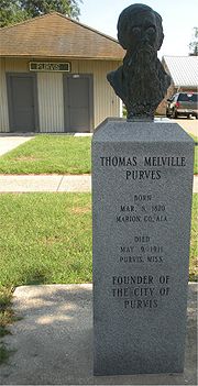
. The Town of Purvis was incorporated on February 25, 1888 and was founded by and named after Thomas Melville Purves, originally of Marion County, Alabama
. Purves, born March 8, 1820 was a second generation Scottish-American whose grandfather immigrated to Charleston
, South Carolina
in 1765.
. In 1871, Purves moved from his home in Greene County
and homesteaded the 160 acre (0.6474976 km²), along with his wife, Dorothy Abney, born May 14, 1826 in Hinds County
, and their five surviving children, to the rural property. Dorothy, also known as Dollie or Dolly, was a doctor who tended the sick of the area and delivered babies. Purves built a two room log cabin
for his family with an open fireplace in one room used for cooking and heating. John, Thomas Purves’ third surviving child, was the town’s first Mayor.
 Thomas and Dorothy’s children are as follows:
In 1884, the New Orleans and Northeastern Railroad
gained right-of-way on Purves’ property and a depot
was erected, along with a marker, reading “Purvis”. There were various recognized spellings of Scottish Clan
Purves (Family Name)
with the two names previously listed being only a few of many. Purves eventually changed the spelling of his surname to match the town’s depot marker which you can see evidenced on his tombstone located in Fillingame Cemetery in Purvis. Purves built and ran the first boarding house
for the men who were working on laying rails for the New Orleans and Northeastern Railroad
. This building was called a “section house” because that is what a house built for railroad crew was termed at that time. Mrs. Anna Bufkin was a member of one of the first families to live in the section house as her husband was one that helped grade and build that part of the railroad in Purvis. There were around fifty men in the crew working in that area and the water supply was inadequate for that many additional people. They found a second source of water from a spring across the railroad track that was originally used by Thomas Purves (Grandpa Purvis) years before the town sprang into existence.
Lamar became a county on February 19, 1904 in House Bill 166 and was formed from the second Judicial District of Marion County
. The county was named after the Honorable L.Q.C. Lamar, who was elected to Mississippi Congress in 1872 and has one county each in Mississippi
, Alabama
and Georgia
named after him. The town of Purvis was designated as the county seat of the county Lamar with the depot of the New Orleans and Northeastern Railroad
listed as the town’s center and the lines to run with the cardinal points of the compass.
Purvis began as a sawmill
town and is noted to be located on the highest point on the Southern Railroad between Meridian and New Orleans by James Bounds, land surveyor, MS REG # L.S.1021. The first homesteaders of the area farmed and would only have to make 2-3 trips to “town” for supplies a year. The best route and the trading post most used was the Pass Christian trading post, some ninety miles south of the area which took eleven days in ox-cart to travel. Mr. James Bounds, surveyor, also states:
“It may be of interest to note the location of the old Pass Christian Road on a map of Stone and Pearl River Counties. This road was used very much by the early settlers of Lamar County to travel south to the coast for supplies. This road followed a natural divide between the water-sheds of Wolf River and Big Black Creek, of which the head waters originate in Lamar County. This road was one of necessity. It crossed no branches or streams of any kind and was one of the main roads of travel until modern means of transportation came into use after the American Civil War
.”
When the town was in its infancy, lumber
companies bought large tracts of virgin pine
forested land and erected sawmills at sites along the newly developing rail line. Thus the town was born. A special meeting of the board of supervisors was held in January, 1905, for the purpose of giving a contract for a new courthouse to be built for the sum of $43,516 to P.H. Weathers (architect) of Jackson
, Mississippi
. This beautiful new two-story brick and stone building would replace the frame courthouse that in use at the time. The new Lamar County
Courthouse was completed in 1905 at a cost of $50,000 only to be damaged by the 1908 Dixie tornado outbreak, then subsequently demolished by fire in 1934. The building was reconstructed and then expanded in 1956 but has fallen into disrepair in the last few years. According to Lamar County Administrator Chuck Bennett on December 30, 2008, the courthouse is slated for a complete renovation that could cost up to 4 million dollars and could take up to four years to complete. Preliminary work began in 2006 and some items have already been paid-in-full, such as engineering services and an asbestos study.
According to the United States Census Bureau
, the city has a total area of 3.9 square miles (10.1 km²), of which 3.9 square miles (10.1 km²) is land and 0.25% is water. Because of a well-known system of aquifers and sand mines, this area was selected for "project dribble" to be the site of nuclear tests by the US government during 1961 to 1968 to measure seismic activity.
, in a humid subtropical area of the country with hot summers and mild winters. Located in USDA Hardiness Zone 8
, the climate supports a large variety of foliage and plants. Purvis receives about 62 inches of rain
annually, January being the wettest month averaging 6.63 inches (168.4 mm), which provides for the lush growth of native plants and trees. January is also the coldest month of the year with an average temperature of 60 degrees during the daytime and 36 degrees at night.
Summers are long with 80 degree temperatures beginning in May or sometimes sooner and lasting normally until the first weeks of October. Night temperatures do not usually vary greatly from daytime temperatures, usually dropping only 21 -24 degrees. Heat indexes can soar during the summer months due to high humidity and long hours of sunshine, causing a 93 degree day to feel as if it were 101 degrees. Afternoon showers and thunderstorms are to be expected during summer months but are often short lived. July is, on average, the hottest month of the year at 92 degrees, without counting the varying heat index
.
Snowfall is rare and when it does occur it usually is only 3 inches (76.2 mm) or less. Purvis averages freezing temperatures only a few times a winter. The record high was in 1951 at 106 degrees and the record low as in 1985 at 4 degrees.
Purvis is part of the area known as the Pine Belt (Mississippi)
due to overwhelming number of longleaf pine
trees that populate the forests.
of 2000, there were 2,164 people, 786 households, and 577 families residing in the city. The population density
was 551.0 people per square mile (212.6/km²). There were 844 housing units at an average density of 214.9 per square mile (82.9/km²). The racial makeup of the city was 70.84% White, 27.68% African American, 0.18% Native American, 0.14% Asian, 0.23% from other races
, and 0.92% from two or more races. Hispanic or Latino of any race were 1.06% of the population.
There were 786 households out of which 34.9% had children under the age of 18 living with them, 48.2% were married couples
living together, 20.2% had a female householder with no husband present, and 26.5% were non-families. 24.8% of all households were made up of individuals and 11.6% had someone living alone who was 65 years of age or older. The average household size was 2.67 and the average family size was 3.16.
In the city the population was spread out with 27.6% under the age of 18, 10.2% from 18 to 24, 27.2% from 25 to 44, 21.9% from 45 to 64, and 13.1% who were 65 years of age or older. The median age was 35 years. For every 100 females there were 90.8 males. For every 100 females age 18 and over, there were 82.8 males.
The median income for a household in the city was $30,938, and the median income for a family was $35,000. Males had a median income of $27,571 versus $17,500 for females. The per capita income
for the city was $13,727. About 11.3% of families and 14.6% of the population were below the poverty line, including 20.0% of those under age 18 and 13.6% of those age 65 or over.
operates the Purvis Post Office in Purvis.
The Mississippi Department of Mental Health
operates the South Mississippi State Hospital
in unincorporated
Lamar County
, near Purvis.
is a tornado
as a testament of the courage of those who endured the Tornadoes of 1908, which changed the face of the emerging town, and in honor of those who lost their lives that day. The city of Purvis is serviced by the Lamar County School District
which includes the following:
Private Schools include:
 The citizens of the city of Purvis has contributed greatly to the various branches of the United States Military beginning long before the town was incorporated. The War Memorial located on the grounds of the Old Lamar County Courthouse holds testament of the heartbreakingly selfless sacrifices the families of the area have made. The Purvis City Park is dedicated to the men and women who served in World War II
and one of the main thoroughfares through the city is named in honor of one of its decorated servicemen.
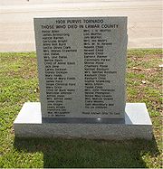
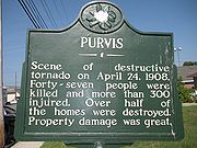 On Friday, April 24, 1908, three F4 (207-260 mph) tornadoes left a line of destruction from Livingston Parish, Louisiana
northeast to Wayne County
. This line of storms left 143 people dead with 83 dead in Purvis alone. From the reports of Dr. H.R. Hermesch, Assistant Surgeon
U.S. Navy and the Relief Committee at Purvis, we know that there were 83 dead, 340 wounded and 1935 destitute in the town of Purvis. The large “Town Clock” in the domed tower of the Courthouse of the time, sustained damage from flying debris and was stopped at 2:13 in the afternoon.
 An excerpt from the booklet “The Purvis Tornado” by the Lamar County Historical Society, 2004:
“The first thought was of Hattiesburg for help. All the wires were down, and they could not telegraph this city for help, so Sheriff George W. Holleman saddled his horse and W.B. Alsworth mounted the steed, and started across the country for Richburg, 10 miles distance toward Hattiesburg
. Mr. Alsworth urged the horse for all he was worth, dashing three veritable creeks, and over rough roads. He made the trip in less than fifty minutes. A second messenger was sent behind Mr. Alsworth, so that if anything happened, the other man might reach the goal and send the news. The other messenger was J.C. Calhoun. Both men reached Richburg about 3 o’clock, Mr. Alsworth sometime ahead of Mr. Calhoun.
Alsworth wired direct over the telephone to Mayor J.D. Donald, asking for physicians to come to the relief of the stricken town.
Mayor Donald immediately made the fact known in the city. A special train over the North Eastern was the result. Thus the new of the terrible disaster was communicated to the outside world.”
 The depot of the New Orleans and Northeastern Railroad
, which was responsible for the success of the bustling, growing town, was one of the first public buildings demolished by the twisters and was thrown across the tracks. Railroad cars standing in front of the depot
were carried away by the winds. Over 115 businesses, buildings and homes were completely demolished or partially destroyed and the entire African-American section of town was wiped out. The Purvis High School graduating Class of 1904’s commencement exercises were due to start the night the tornado
hit and part of the exercises had been previously performed the morning of the tornado. The morning exercises were completed at the two story brick schoolhouse on Mitchell Street just one hour before the storm hit and had it lasted one hour longer, the death toll would have been far greater for the entire second floor of the schoolhouse was removed by the twister.
the city is located. Category 5 Hurricane Ethel
came in 1960 but died down to a tropical storm by the time she had reached the area. Hurricane Hilda
in 1964 was not a Category 4 but an extratropical low when she deposited rain in Lamar County. Due to the close proximity of Lamar County
to Louisiana
, Hurricane Betsy
in 1965 also left Purvis some rain. The eye of Hurricane Camille
came directly over Lamar County in 1969 and was the largest, costliest and most deadly hurricane to hit the Mississippi Gulf Coast until the monster storm Katrina in 2005. Hurricane Edith came in 1971, followed by Hurricane Carmen
in 1974 that drenched us with 7 inches (177.8 mm) of rain before heading off to Texas. Hurricane Bob
made an appearance in 1979 but was quickly forgotten when Hurricane Elena
made her way over the area in 1985 as a Category 3 storm. That same year, Purvis received more rain than wind from Category 1 Hurricane Juan
. Hurricane Florence
passed by in 1988, leaving only rain as a weakening Category 1 storm. In 1992, Hurricane Andrew
had thankfully died down from its original Category 5 when it came over and dropped 5 inches (127 mm) of rain. Hurricane Georges
gave Purvis 5–7 inches of precipitation in 1998, and also some wind before curving back over Alabama. Hurricane Allison oddly stayed together long enough to still have an eye like feature over Purvis after traveling from Texas and Louisiana in 2001 and dumped 10–15 inches of rain on Lamar County
.
Mississippi
felt the effects of The Hurricane in 2005, Hurricane Katrina
, which hit the area as a weakening Category 2 hurricane after reaching Category 5 strength in the Gulf of Mexico. This storm killed 1836 people, 238 of them in Mississippi. The effects from this hurricane can still be seen four years later in the forests around Purvis. Hurricane Gustav
passed a little south of the area in 2008 but was close enough to leave wind and rain in its wake.
was an element of Project Vela
conducted jointly by the United States Department of Energy
(DOE) and the Advanced Research Projects Agency (ARPA). Its purpose was to develop seismic methods for detecting underground nuclear testing
.
The Project Dribble program involved two nuclear detonations called Salmon and Sterling that were conducted within Tatum Salt Dome southwest of the Hattiesburg/Purvis area in the late 60's.
The Sterling Event was the fourth nuclear detonation involved in a study, identified as Project Dribble, sponsored by the Department of Defense's Advanced Research Project Agency. Project Dribble involves the recording and identification of seismic signals from underground detonations. These studies are part of a seismic research program called Vela Uniform which is designed to improve the United States' capability to detect, identify, and locate underground nuclear detonations.
Project Dribble's purpose was to give U.S. scientists experience in detecting underground nuclear tests in the Soviet Union
. The first blast, a 5.3 kiloton bomb, took place in 1964 at the bottom of a 2710 feet (826 m) shaft 28 miles (45.1 km) southwest of Hattiesburg and four miles (6 km) northeast of Baxterville. The second bomb, much smaller, was exploded two years later within the cavity created by the first blast. (To be sure, these were only two of well over a thousand documented nuclear tests by the United States, with the vast majority taking place in Nevada.)
by Afroman
. Afroman is said to be "swerving his Cadillac through Purvis."
Lamar County, Mississippi
-Demographics:As of the census of 2000, there were 39,070 people, 14,396 households, and 10,725 families residing in the county. The population density was 79 people per square mile . There were 15,433 housing units at an average density of 31 per square mile...
, Mississippi
Mississippi
Mississippi is a U.S. state located in the Southern United States. Jackson is the state capital and largest city. The name of the state derives from the Mississippi River, which flows along its western boundary, whose name comes from the Ojibwe word misi-ziibi...
, United States
United States
The United States of America is a federal constitutional republic comprising fifty states and a federal district...
. It is part of the Hattiesburg, Mississippi Metropolitan Statistical Area
Hattiesburg metropolitan area
The Hattiesburg Metropolitan Statistical Area is a metropolitan area in southeastern Mississippi that covers three counties - Forrest, Lamar, and Perry...
. The population was 2,164 at the 2000 census. It is the county seat
County seat
A county seat is an administrative center, or seat of government, for a county or civil parish. The term is primarily used in the United States....
of Lamar County
Lamar County, Mississippi
-Demographics:As of the census of 2000, there were 39,070 people, 14,396 households, and 10,725 families residing in the county. The population density was 79 people per square mile . There were 15,433 housing units at an average density of 31 per square mile...
. The Town of Purvis was incorporated on February 25, 1888 and was founded by and named after Thomas Melville Purves, originally of Marion County, Alabama
Marion County, Alabama
Marion County is a county of the U.S. state of Alabama. Marion County was created by an act of the Alabama Territorial General Assembly on February 13, 1818. The county is located in the northwestern part of the state, bounded on the west by the state of Mississippi. It encompasses . Marion County...
. Purves, born March 8, 1820 was a second generation Scottish-American whose grandfather immigrated to Charleston
Charleston, South Carolina
Charleston is the second largest city in the U.S. state of South Carolina. It was made the county seat of Charleston County in 1901 when Charleston County was founded. The city's original name was Charles Towne in 1670, and it moved to its present location from a location on the west bank of the...
, South Carolina
South Carolina
South Carolina is a state in the Deep South of the United States that borders Georgia to the south, North Carolina to the north, and the Atlantic Ocean to the east. Originally part of the Province of Carolina, the Province of South Carolina was one of the 13 colonies that declared independence...
in 1765.
History
Purves acquired a land grant in 1870 for a parcel of real estate which was located, at that time, in Marion County, MississippiMarion County, Mississippi
-Demographics:As of the census of 2000, there were 25,595 people, 9,336 households, and 6,880 families residing in the county. The population density was 47 people per square mile . There were 10,395 housing units at an average density of 19 per square mile...
. In 1871, Purves moved from his home in Greene County
Greene County, Mississippi
-Demographics:As of the census of 2000, there were 13,299 people, 4,148 households, and 3,152 families residing in the county. The population density was 19 people per square mile . There were 4,947 housing units at an average density of 7 per square mile...
and homesteaded the 160 acre (0.6474976 km²), along with his wife, Dorothy Abney, born May 14, 1826 in Hinds County
Hinds County, Mississippi
As of the census of 2000, there were 250,800 people, 91,030 households, and 62,355 families residing in the county. The population density was 288 people per square mile . There were 100,287 housing units at an average density of 115 per square mile...
, and their five surviving children, to the rural property. Dorothy, also known as Dollie or Dolly, was a doctor who tended the sick of the area and delivered babies. Purves built a two room log cabin
Log cabin
A log cabin is a house built from logs. It is a fairly simple type of log house. A distinction should be drawn between the traditional meanings of "log cabin" and "log house." Historically most "Log cabins" were a simple one- or 1½-story structures, somewhat impermanent, and less finished or less...
for his family with an open fireplace in one room used for cooking and heating. John, Thomas Purves’ third surviving child, was the town’s first Mayor.
- Joseph Abney Purvis born 10/28/1845, died 1865 in Jasper County, MS on the way home from the Civil War with a case of the measles. Buried in Fillingame Cemetery, Purvis, MS.
- Sarah Elizabeth Purvis, born 12/18/1847, died 10/28/90 in Purvis. Buried in cemetery next to Methodist Church. Married Andrew J. Clark born about 1850, died about 1890.
- John Boardman Purvis, born 4/2/1850, died 1/15/1921 in Purvis, MS. Buried in Coaltown Cemetery, Purvis, MS. Married Nancy Baxter born about 1850, died about 1940.
- Oliver Searcy Purvis, born 6/12/1852, died 4/22/1927 in Purvis, MS.
- Susan Margaret Purvis, born 10/26/1853, died 6/27/1930 in Purvis, MS. Buried in Coaltown Cemetery. Married Plummer Ladner, born about 1850, died about 1925.
- Martha Catherine Purvis, born 11/18/1862, died 11/15/1948 in Purvis, MS. Buried in Coaltown Cemetery. Married Henry W. Fillingame born about 1850, died about 1930.
- Infant Purvis born about 1850, died about 1860.
- Infant Purvis born about 1850.
In 1884, the New Orleans and Northeastern Railroad
New Orleans and Northeastern Railroad
The New Orleans and Northeastern Railroad was a Class I railroad in Louisiana and Mississippi in the United States. The railroad operated of track from its completion in 1883 until it was absorbed by the Alabama Great Southern Railroad subsidiary of the Southern Railway in 1969.- History :The...
gained right-of-way on Purves’ property and a depot
Train station
A train station, also called a railroad station or railway station and often shortened to just station,"Station" is commonly understood to mean "train station" unless otherwise qualified. This is evident from dictionary entries e.g...
was erected, along with a marker, reading “Purvis”. There were various recognized spellings of Scottish Clan
Clan
A clan is a group of people united by actual or perceived kinship and descent. Even if lineage details are unknown, clan members may be organized around a founding member or apical ancestor. The kinship-based bonds may be symbolical, whereby the clan shares a "stipulated" common ancestor that is a...
Purves (Family Name)
Purves (Family Name)
The Purves family history can be traced back to 1066 AD. During the Battle of Hastings, the Purves family gave significant military service to William the Conqueror...
with the two names previously listed being only a few of many. Purves eventually changed the spelling of his surname to match the town’s depot marker which you can see evidenced on his tombstone located in Fillingame Cemetery in Purvis. Purves built and ran the first boarding house
Boarding house
A boarding house, is a house in which lodgers rent one or more rooms for one or more nights, and sometimes for extended periods of weeks, months and years. The common parts of the house are maintained, and some services, such as laundry and cleaning, may be supplied. They normally provide "bed...
for the men who were working on laying rails for the New Orleans and Northeastern Railroad
New Orleans and Northeastern Railroad
The New Orleans and Northeastern Railroad was a Class I railroad in Louisiana and Mississippi in the United States. The railroad operated of track from its completion in 1883 until it was absorbed by the Alabama Great Southern Railroad subsidiary of the Southern Railway in 1969.- History :The...
. This building was called a “section house” because that is what a house built for railroad crew was termed at that time. Mrs. Anna Bufkin was a member of one of the first families to live in the section house as her husband was one that helped grade and build that part of the railroad in Purvis. There were around fifty men in the crew working in that area and the water supply was inadequate for that many additional people. They found a second source of water from a spring across the railroad track that was originally used by Thomas Purves (Grandpa Purvis) years before the town sprang into existence.
Lamar became a county on February 19, 1904 in House Bill 166 and was formed from the second Judicial District of Marion County
Marion County, Mississippi
-Demographics:As of the census of 2000, there were 25,595 people, 9,336 households, and 6,880 families residing in the county. The population density was 47 people per square mile . There were 10,395 housing units at an average density of 19 per square mile...
. The county was named after the Honorable L.Q.C. Lamar, who was elected to Mississippi Congress in 1872 and has one county each in Mississippi
Mississippi
Mississippi is a U.S. state located in the Southern United States. Jackson is the state capital and largest city. The name of the state derives from the Mississippi River, which flows along its western boundary, whose name comes from the Ojibwe word misi-ziibi...
, Alabama
Alabama
Alabama is a state located in the southeastern region of the United States. It is bordered by Tennessee to the north, Georgia to the east, Florida and the Gulf of Mexico to the south, and Mississippi to the west. Alabama ranks 30th in total land area and ranks second in the size of its inland...
and Georgia
Georgia (U.S. state)
Georgia is a state located in the southeastern United States. It was established in 1732, the last of the original Thirteen Colonies. The state is named after King George II of Great Britain. Georgia was the fourth state to ratify the United States Constitution, on January 2, 1788...
named after him. The town of Purvis was designated as the county seat of the county Lamar with the depot of the New Orleans and Northeastern Railroad
New Orleans and Northeastern Railroad
The New Orleans and Northeastern Railroad was a Class I railroad in Louisiana and Mississippi in the United States. The railroad operated of track from its completion in 1883 until it was absorbed by the Alabama Great Southern Railroad subsidiary of the Southern Railway in 1969.- History :The...
listed as the town’s center and the lines to run with the cardinal points of the compass.
Purvis began as a sawmill
Sawmill
A sawmill is a facility where logs are cut into boards.-Sawmill process:A sawmill's basic operation is much like those of hundreds of years ago; a log enters on one end and dimensional lumber exits on the other end....
town and is noted to be located on the highest point on the Southern Railroad between Meridian and New Orleans by James Bounds, land surveyor, MS REG # L.S.1021. The first homesteaders of the area farmed and would only have to make 2-3 trips to “town” for supplies a year. The best route and the trading post most used was the Pass Christian trading post, some ninety miles south of the area which took eleven days in ox-cart to travel. Mr. James Bounds, surveyor, also states:
“It may be of interest to note the location of the old Pass Christian Road on a map of Stone and Pearl River Counties. This road was used very much by the early settlers of Lamar County to travel south to the coast for supplies. This road followed a natural divide between the water-sheds of Wolf River and Big Black Creek, of which the head waters originate in Lamar County. This road was one of necessity. It crossed no branches or streams of any kind and was one of the main roads of travel until modern means of transportation came into use after the American Civil War
American Civil War
The American Civil War was a civil war fought in the United States of America. In response to the election of Abraham Lincoln as President of the United States, 11 southern slave states declared their secession from the United States and formed the Confederate States of America ; the other 25...
.”
When the town was in its infancy, lumber
Lumber
Lumber or timber is wood in any of its stages from felling through readiness for use as structural material for construction, or wood pulp for paper production....
companies bought large tracts of virgin pine
Pine
Pines are trees in the genus Pinus ,in the family Pinaceae. They make up the monotypic subfamily Pinoideae. There are about 115 species of pine, although different authorities accept between 105 and 125 species.-Etymology:...
forested land and erected sawmills at sites along the newly developing rail line. Thus the town was born. A special meeting of the board of supervisors was held in January, 1905, for the purpose of giving a contract for a new courthouse to be built for the sum of $43,516 to P.H. Weathers (architect) of Jackson
Jackson, Mississippi
Jackson is the capital and the most populous city of the US state of Mississippi. It is one of two county seats of Hinds County ,. The population of the city declined from 184,256 at the 2000 census to 173,514 at the 2010 census...
, Mississippi
Mississippi
Mississippi is a U.S. state located in the Southern United States. Jackson is the state capital and largest city. The name of the state derives from the Mississippi River, which flows along its western boundary, whose name comes from the Ojibwe word misi-ziibi...
. This beautiful new two-story brick and stone building would replace the frame courthouse that in use at the time. The new Lamar County
Lamar County, Mississippi
-Demographics:As of the census of 2000, there were 39,070 people, 14,396 households, and 10,725 families residing in the county. The population density was 79 people per square mile . There were 15,433 housing units at an average density of 31 per square mile...
Courthouse was completed in 1905 at a cost of $50,000 only to be damaged by the 1908 Dixie tornado outbreak, then subsequently demolished by fire in 1934. The building was reconstructed and then expanded in 1956 but has fallen into disrepair in the last few years. According to Lamar County Administrator Chuck Bennett on December 30, 2008, the courthouse is slated for a complete renovation that could cost up to 4 million dollars and could take up to four years to complete. Preliminary work began in 2006 and some items have already been paid-in-full, such as engineering services and an asbestos study.
Geography
Purvis is located at 31°8′33"N 89°24′28"W (31.142616, -89.407724).According to the United States Census Bureau
United States Census Bureau
The United States Census Bureau is the government agency that is responsible for the United States Census. It also gathers other national demographic and economic data...
, the city has a total area of 3.9 square miles (10.1 km²), of which 3.9 square miles (10.1 km²) is land and 0.25% is water. Because of a well-known system of aquifers and sand mines, this area was selected for "project dribble" to be the site of nuclear tests by the US government during 1961 to 1968 to measure seismic activity.
Climate
Purvis is located in the Deep SouthDeep South
The Deep South is a descriptive category of the cultural and geographic subregions in the American South. Historically, it is differentiated from the "Upper South" as being the states which were most dependent on plantation type agriculture during the pre-Civil War period...
, in a humid subtropical area of the country with hot summers and mild winters. Located in USDA Hardiness Zone 8
Hardiness zone
A hardiness zone is a geographically defined area in which a specific category of plant life is capable of growing, as defined by climatic conditions, including its ability to withstand the minimum temperatures of the zone...
, the climate supports a large variety of foliage and plants. Purvis receives about 62 inches of rain
Rain
Rain is liquid precipitation, as opposed to non-liquid kinds of precipitation such as snow, hail and sleet. Rain requires the presence of a thick layer of the atmosphere to have temperatures above the melting point of water near and above the Earth's surface...
annually, January being the wettest month averaging 6.63 inches (168.4 mm), which provides for the lush growth of native plants and trees. January is also the coldest month of the year with an average temperature of 60 degrees during the daytime and 36 degrees at night.
Summers are long with 80 degree temperatures beginning in May or sometimes sooner and lasting normally until the first weeks of October. Night temperatures do not usually vary greatly from daytime temperatures, usually dropping only 21 -24 degrees. Heat indexes can soar during the summer months due to high humidity and long hours of sunshine, causing a 93 degree day to feel as if it were 101 degrees. Afternoon showers and thunderstorms are to be expected during summer months but are often short lived. July is, on average, the hottest month of the year at 92 degrees, without counting the varying heat index
Heat index
The heat index is an index that combines air temperature and relative humidity in an attempt to determine the human-perceived equivalent temperature — how hot it feels, termed the felt air temperature. The human body normally cools itself by perspiration, or sweating, which evaporates and carries...
.
Snowfall is rare and when it does occur it usually is only 3 inches (76.2 mm) or less. Purvis averages freezing temperatures only a few times a winter. The record high was in 1951 at 106 degrees and the record low as in 1985 at 4 degrees.
Major Highways
-
 Interstate 59Interstate 59Interstate 59 is an Interstate Highway in the southern United States. Its southern terminus is near Slidell, Louisiana, a suburb of New Orleans, at an intersection with Interstate 10 and Interstate 12, its northern terminus is at Wildwood, Georgia, at an intersection with Interstate 24.The road's...
 -
 US 11 (MS)
 -
 Mississippi Highway 589
Purvis is part of the area known as the Pine Belt (Mississippi)
Pine Belt (Mississippi)
The Pine Belt, also known as the "Piney Woods", is a region in Southeast Mississippi. The region gets its name from the longleaf pine trees that are abundant in the region.- Geography :The Longleaf Pine belt covers 36 counties in Mississippi...
due to overwhelming number of longleaf pine
Longleaf Pine
Pinus palustris, commonly known as the Longleaf Pine, is a pine native to the southeastern United States, found along the coastal plain from eastern Texas to southeast Virginia extending into northern and central Florida....
trees that populate the forests.
Demographics
As of the censusCensus
A census is the procedure of systematically acquiring and recording information about the members of a given population. It is a regularly occurring and official count of a particular population. The term is used mostly in connection with national population and housing censuses; other common...
of 2000, there were 2,164 people, 786 households, and 577 families residing in the city. The population density
Population density
Population density is a measurement of population per unit area or unit volume. It is frequently applied to living organisms, and particularly to humans...
was 551.0 people per square mile (212.6/km²). There were 844 housing units at an average density of 214.9 per square mile (82.9/km²). The racial makeup of the city was 70.84% White, 27.68% African American, 0.18% Native American, 0.14% Asian, 0.23% from other races
Race (United States Census)
Race and ethnicity in the United States Census, as defined by the Federal Office of Management and Budget and the United States Census Bureau, are self-identification data items in which residents choose the race or races with which they most closely identify, and indicate whether or not they are...
, and 0.92% from two or more races. Hispanic or Latino of any race were 1.06% of the population.
There were 786 households out of which 34.9% had children under the age of 18 living with them, 48.2% were married couples
Marriage
Marriage is a social union or legal contract between people that creates kinship. It is an institution in which interpersonal relationships, usually intimate and sexual, are acknowledged in a variety of ways, depending on the culture or subculture in which it is found...
living together, 20.2% had a female householder with no husband present, and 26.5% were non-families. 24.8% of all households were made up of individuals and 11.6% had someone living alone who was 65 years of age or older. The average household size was 2.67 and the average family size was 3.16.
In the city the population was spread out with 27.6% under the age of 18, 10.2% from 18 to 24, 27.2% from 25 to 44, 21.9% from 45 to 64, and 13.1% who were 65 years of age or older. The median age was 35 years. For every 100 females there were 90.8 males. For every 100 females age 18 and over, there were 82.8 males.
The median income for a household in the city was $30,938, and the median income for a family was $35,000. Males had a median income of $27,571 versus $17,500 for females. The per capita income
Per capita income
Per capita income or income per person is a measure of mean income within an economic aggregate, such as a country or city. It is calculated by taking a measure of all sources of income in the aggregate and dividing it by the total population...
for the city was $13,727. About 11.3% of families and 14.6% of the population were below the poverty line, including 20.0% of those under age 18 and 13.6% of those age 65 or over.
Government and infrastructure
The United States Postal ServiceUnited States Postal Service
The United States Postal Service is an independent agency of the United States government responsible for providing postal service in the United States...
operates the Purvis Post Office in Purvis.
The Mississippi Department of Mental Health
Mississippi Department of Mental Health
The Mississippi Department of Mental Health is a state agency of Mississippi, headquartered in Suite 1101 of the Robert E. Lee Building in Jackson...
operates the South Mississippi State Hospital
South Mississippi State Hospital
The South Mississippi State Hospital is an acute care regional psychiatric facility of the Mississippi Department of Mental Health located in unincorporated Lamar County, Mississippi, near Purvis...
in unincorporated
Unincorporated area
In law, an unincorporated area is a region of land that is not a part of any municipality.To "incorporate" in this context means to form a municipal corporation, a city, town, or village with its own government. An unincorporated community is usually not subject to or taxed by a municipal government...
Lamar County
Lamar County, Mississippi
-Demographics:As of the census of 2000, there were 39,070 people, 14,396 households, and 10,725 families residing in the county. The population density was 79 people per square mile . There were 15,433 housing units at an average density of 31 per square mile...
, near Purvis.
Education
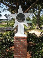
The Purvis School System’s mascotMascot
The term mascot – defined as a term for any person, animal, or object thought to bring luck – colloquially includes anything used to represent a group with a common public identity, such as a school, professional sports team, society, military unit, or brand name...
is a tornado
Tornado
A tornado is a violent, dangerous, rotating column of air that is in contact with both the surface of the earth and a cumulonimbus cloud or, in rare cases, the base of a cumulus cloud. They are often referred to as a twister or a cyclone, although the word cyclone is used in meteorology in a wider...
as a testament of the courage of those who endured the Tornadoes of 1908, which changed the face of the emerging town, and in honor of those who lost their lives that day. The city of Purvis is serviced by the Lamar County School District
Lamar County School District
The Lamar County School District is a public school district based in Purvis, Mississippi .In addition to Purvis, the district also serves the town of Sumrall, the communities of West Hattiesburg and Baxterville as well as most rural areas in Lamar County.-Schools:*Oak Grove High School *Purvis...
which includes the following:
- Purvis Lower Elementary School K-2
- Purvis Upper Elementary School 3-5
- Purvis Middle School 6-8
- Purvis High SchoolPurvis High SchoolPurvis High School is a school within the Lamar County School District. It is located in Purvis at the address: 220 School St. Purvis, MS 39475....
9-12
Private Schools include:
- Lamar Christian School
- Bass Memorial Academy
Military Contributions
World War II
World War II, or the Second World War , was a global conflict lasting from 1939 to 1945, involving most of the world's nations—including all of the great powers—eventually forming two opposing military alliances: the Allies and the Axis...
and one of the main thoroughfares through the city is named in honor of one of its decorated servicemen.
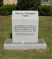
Tornadoes of 1908
Livingston Parish, Louisiana
Livingston Parish Is a parish located in the U.S. state of Louisiana. Its parish seat is Livingston. As of 2010, its population was 128,026....
northeast to Wayne County
Wayne County, Mississippi
-Demographics:As of the census of 2000, there were 21,216 people, 7,857 households, and 5,853 families residing in the county. The population density was 26 people per square mile . There were 9,049 housing units at an average density of 11 per square mile...
. This line of storms left 143 people dead with 83 dead in Purvis alone. From the reports of Dr. H.R. Hermesch, Assistant Surgeon
Surgeon
In medicine, a surgeon is a specialist in surgery. Surgery is a broad category of invasive medical treatment that involves the cutting of a body, whether human or animal, for a specific reason such as the removal of diseased tissue or to repair a tear or breakage...
U.S. Navy and the Relief Committee at Purvis, we know that there were 83 dead, 340 wounded and 1935 destitute in the town of Purvis. The large “Town Clock” in the domed tower of the Courthouse of the time, sustained damage from flying debris and was stopped at 2:13 in the afternoon.
“The first thought was of Hattiesburg for help. All the wires were down, and they could not telegraph this city for help, so Sheriff George W. Holleman saddled his horse and W.B. Alsworth mounted the steed, and started across the country for Richburg, 10 miles distance toward Hattiesburg
Hattiesburg, Mississippi
Hattiesburg is a city in Forrest County, Mississippi, United States. The population was 44,779 at the 2000 census . It is the county seat of Forrest County...
. Mr. Alsworth urged the horse for all he was worth, dashing three veritable creeks, and over rough roads. He made the trip in less than fifty minutes. A second messenger was sent behind Mr. Alsworth, so that if anything happened, the other man might reach the goal and send the news. The other messenger was J.C. Calhoun. Both men reached Richburg about 3 o’clock, Mr. Alsworth sometime ahead of Mr. Calhoun.
Alsworth wired direct over the telephone to Mayor J.D. Donald, asking for physicians to come to the relief of the stricken town.
Mayor Donald immediately made the fact known in the city. A special train over the North Eastern was the result. Thus the new of the terrible disaster was communicated to the outside world.”
New Orleans and Northeastern Railroad
The New Orleans and Northeastern Railroad was a Class I railroad in Louisiana and Mississippi in the United States. The railroad operated of track from its completion in 1883 until it was absorbed by the Alabama Great Southern Railroad subsidiary of the Southern Railway in 1969.- History :The...
, which was responsible for the success of the bustling, growing town, was one of the first public buildings demolished by the twisters and was thrown across the tracks. Railroad cars standing in front of the depot
Train station
A train station, also called a railroad station or railway station and often shortened to just station,"Station" is commonly understood to mean "train station" unless otherwise qualified. This is evident from dictionary entries e.g...
were carried away by the winds. Over 115 businesses, buildings and homes were completely demolished or partially destroyed and the entire African-American section of town was wiped out. The Purvis High School graduating Class of 1904’s commencement exercises were due to start the night the tornado
Tornado
A tornado is a violent, dangerous, rotating column of air that is in contact with both the surface of the earth and a cumulonimbus cloud or, in rare cases, the base of a cumulus cloud. They are often referred to as a twister or a cyclone, although the word cyclone is used in meteorology in a wider...
hit and part of the exercises had been previously performed the morning of the tornado. The morning exercises were completed at the two story brick schoolhouse on Mitchell Street just one hour before the storm hit and had it lasted one hour longer, the death toll would have been far greater for the entire second floor of the schoolhouse was removed by the twister.
Hurricanes
Purvis has felt the winds of quite a few tropical systems over the years; especially considering how many miles from the Mississippi Gulf CoastMississippi Gulf Coast
The Mississippi Gulf Coast refers to the three Mississippi counties which lie on the Gulf of Mexico: Hancock, Harrison and Jackson counties.The region was severely damaged by Hurricane Camille in 1969 and again by Hurricane Katrina in 2005....
the city is located. Category 5 Hurricane Ethel
Hurricane Ethel
Hurricane Ethel was both one of the fastest intensifying and weakening storms on record, reaching Category 5 status 18 hours after being declared a tropical storm and weakening from that intensity to a tropical storm in roughly 12 hours...
came in 1960 but died down to a tropical storm by the time she had reached the area. Hurricane Hilda
Hurricane Hilda
Hurricane Hilda was the third hurricane to make landfall in the United States during the 1964 Atlantic hurricane season. Originating near Cuba, the cyclone intensified while moving through the Gulf of Mexico, and became a Category 4 hurricane in the Gulf of Mexico before striking Louisiana in...
in 1964 was not a Category 4 but an extratropical low when she deposited rain in Lamar County. Due to the close proximity of Lamar County
Lamar County, Mississippi
-Demographics:As of the census of 2000, there were 39,070 people, 14,396 households, and 10,725 families residing in the county. The population density was 79 people per square mile . There were 15,433 housing units at an average density of 31 per square mile...
to Louisiana
Louisiana
Louisiana is a state located in the southern region of the United States of America. Its capital is Baton Rouge and largest city is New Orleans. Louisiana is the only state in the U.S. with political subdivisions termed parishes, which are local governments equivalent to counties...
, Hurricane Betsy
Hurricane Betsy
Hurricane Betsy was a Category 4 hurricane of the 1965 Atlantic hurricane season which caused enormous damage in the Bahamas, Florida, and Louisiana. Betsy made its most intense landfall near the mouth of the Mississippi River, causing significant flooding of the waters of Lake Pontchartrain into...
in 1965 also left Purvis some rain. The eye of Hurricane Camille
Hurricane Camille
Hurricane Camille was the third and strongest tropical cyclone and second hurricane during the 1969 Atlantic hurricane season. The second of three catastrophic Category 5 hurricanes to make landfall in the United States during the 20th century , which it did near the mouth of the Mississippi River...
came directly over Lamar County in 1969 and was the largest, costliest and most deadly hurricane to hit the Mississippi Gulf Coast until the monster storm Katrina in 2005. Hurricane Edith came in 1971, followed by Hurricane Carmen
Hurricane Carmen
Hurricane Carmen was the most intense tropical cyclone of the 1974 Atlantic hurricane season. A destructive and widespread storm, Carmen originated as a tropical disturbance that emerged from Africa toward the end of August. The wave traveled westward, spawning a tropical depression east of the...
in 1974 that drenched us with 7 inches (177.8 mm) of rain before heading off to Texas. Hurricane Bob
Hurricane Bob
Hurricane Bob was one of the costliest hurricanes in New England history. The second named storm and first hurricane of the 1991 Atlantic hurricane season, Bob developed from an area of low pressure near The Bahamas on August 16. The depression steadily intensified, and became Tropical Storm Bob...
made an appearance in 1979 but was quickly forgotten when Hurricane Elena
Hurricane Elena
Hurricane Elena was a category 3 major hurricane that produced heavy damage along the Gulf Coast of the United States in August and September of the 1985 Atlantic hurricane season. The fifth tropical storm, fourth hurricane, and first major hurricane of the season, Elena developed near Cuba from a...
made her way over the area in 1985 as a Category 3 storm. That same year, Purvis received more rain than wind from Category 1 Hurricane Juan
Hurricane Juan
Hurricane Juan was a significant hurricane that struck the southern part of Atlantic Canada in late September 2003. It was the tenth named storm and the sixth hurricane of the 2003 Atlantic hurricane season. Juan formed southeast of Bermuda on September 24, 2003 out of a tropical wave that tracked...
. Hurricane Florence
Hurricane Florence (1988)
Hurricane Florence was the third of four named tropical cyclones to make landfall on the United States during the 1988 Atlantic hurricane season. The seventh tropical storm and second hurricane of the season, Florence developed on September 7 from an area of convection associated with a dissipating...
passed by in 1988, leaving only rain as a weakening Category 1 storm. In 1992, Hurricane Andrew
Hurricane Andrew
Hurricane Andrew was the third Category 5 hurricane to make landfall in the United States, after the Labor Day Hurricane of 1935 and Hurricane Camille in 1969. Andrew was the first named storm and only major hurricane of the otherwise inactive 1992 Atlantic hurricane season...
had thankfully died down from its original Category 5 when it came over and dropped 5 inches (127 mm) of rain. Hurricane Georges
Hurricane Georges
Hurricane Georges was a very destructive, powerful and long-lived Cape Verde-type Category 4 hurricane. Georges was the seventh tropical storm, fourth hurricane, and second major hurricane of the 1998 Atlantic hurricane season...
gave Purvis 5–7 inches of precipitation in 1998, and also some wind before curving back over Alabama. Hurricane Allison oddly stayed together long enough to still have an eye like feature over Purvis after traveling from Texas and Louisiana in 2001 and dumped 10–15 inches of rain on Lamar County
Lamar County, Mississippi
-Demographics:As of the census of 2000, there were 39,070 people, 14,396 households, and 10,725 families residing in the county. The population density was 79 people per square mile . There were 15,433 housing units at an average density of 31 per square mile...
.
Mississippi
Mississippi
Mississippi is a U.S. state located in the Southern United States. Jackson is the state capital and largest city. The name of the state derives from the Mississippi River, which flows along its western boundary, whose name comes from the Ojibwe word misi-ziibi...
felt the effects of The Hurricane in 2005, Hurricane Katrina
Hurricane Katrina
Hurricane Katrina of the 2005 Atlantic hurricane season was a powerful Atlantic hurricane. It is the costliest natural disaster, as well as one of the five deadliest hurricanes, in the history of the United States. Among recorded Atlantic hurricanes, it was the sixth strongest overall...
, which hit the area as a weakening Category 2 hurricane after reaching Category 5 strength in the Gulf of Mexico. This storm killed 1836 people, 238 of them in Mississippi. The effects from this hurricane can still be seen four years later in the forests around Purvis. Hurricane Gustav
Hurricane Gustav
The name Gustav has been used for five tropical cyclones in the Atlantic Ocean:* 1984's Tropical Storm Gustav - Spent most of its existence as a tropical depression hovering over Bermuda, no major damage was reported....
passed a little south of the area in 2008 but was close enough to leave wind and rain in its wake.
1960's Vela Uniform/Project Dribble Nuclear Tests
Vela UniformVela Uniform
Vela Uniform was an element of Project Vela conducted jointly by the United States Department of Energy and the Advanced Research Projects Agency...
was an element of Project Vela
Project Vela
Project Vela was a project by the United States to develop and implement methods to monitor compliance with the 1963 Partial Test Ban Treaty. The development work was primarily performed by the Advanced Research Projects Agency and was overseen by the United States Air Force.Project Vela consisted...
conducted jointly by the United States Department of Energy
United States Department of Energy
The United States Department of Energy is a Cabinet-level department of the United States government concerned with the United States' policies regarding energy and safety in handling nuclear material...
(DOE) and the Advanced Research Projects Agency (ARPA). Its purpose was to develop seismic methods for detecting underground nuclear testing
Underground nuclear testing
Underground nuclear testing refers to test detonations of nuclear weapons that are performed underground. When the device being tested is buried at sufficient depth, the explosion may be contained, with no release of radioactive materials to the atmosphere....
.
The Project Dribble program involved two nuclear detonations called Salmon and Sterling that were conducted within Tatum Salt Dome southwest of the Hattiesburg/Purvis area in the late 60's.
The Sterling Event was the fourth nuclear detonation involved in a study, identified as Project Dribble, sponsored by the Department of Defense's Advanced Research Project Agency. Project Dribble involves the recording and identification of seismic signals from underground detonations. These studies are part of a seismic research program called Vela Uniform which is designed to improve the United States' capability to detect, identify, and locate underground nuclear detonations.
Project Dribble's purpose was to give U.S. scientists experience in detecting underground nuclear tests in the Soviet Union
Soviet Union
The Soviet Union , officially the Union of Soviet Socialist Republics , was a constitutionally socialist state that existed in Eurasia between 1922 and 1991....
. The first blast, a 5.3 kiloton bomb, took place in 1964 at the bottom of a 2710 feet (826 m) shaft 28 miles (45.1 km) southwest of Hattiesburg and four miles (6 km) northeast of Baxterville. The second bomb, much smaller, was exploded two years later within the cavity created by the first blast. (To be sure, these were only two of well over a thousand documented nuclear tests by the United States, with the vast majority taking place in Nevada.)
Notable Residents (Past & Present)
- Lacey ChabertLacey ChabertLacey Nicole Chabert is an American actress and voice actress, known for her roles as Claudia Salinger in the television drama Party of Five and as Gretchen Wieners in the movie Mean Girls...
, film and television actress. - Billy Hudson Sr., CEO of Hudson Salvage (retired) and State Senator.
In Pop Culture
Referenced in the song "Mississippi" off the CD The Good TimesThe Good Times
The Good Times is a greatest hits compilation album by hip hop artist Afroman. It was released after his record deal with Universal Records. It contains his two hit singles: "Because I Got High" and "Crazy Rap", along with his other popular songs from his two albums. The song "Mississippi" is...
by Afroman
Afroman
Joseph Edgar Foreman , better known by his stage name Afroman, is an American rapper who came to prominence with his singles "Because I Got High" and "Crazy Rap". "Because I Got High" circulated around the Internet before becoming a hit worldwide...
. Afroman is said to be "swerving his Cadillac through Purvis."
External links
- The CLUI Land Use Database: Salmon and Sterling Nuclear Test Sites
- Significant Past Weather Occurrences in the South Central States
- Epic Disasters
- Fact Sheet on Purvis, Salmon Nuclear Test Site
- Lamar County School District Website
- Purvis Lower Elementary Website
- Purvis Upper Elementary Website
- Purvis Middle School Website
- Purvis High School Website
- Lamar Christian School Website
- Bass Memorial Academy Website
- Lamar County Public Library
- Little Black Creek Water Park