
Hurricane Ethel
Encyclopedia
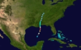
Hurricane Ethel was both one of the fastest intensifying and weakening storms on record, reaching Category 5 status 18 hours after being declared a tropical storm and weakening from that intensity to a tropical storm in roughly 12 hours. Ethel formed in the Gulf of Mexico
on the morning of September 14, 1960, rapidly intensified into a potentially catastrophic Category 5 hurricane, and weakened back to a tropical storm before making landfall near Biloxi, Mississippi
, the next evening. Because of the rapid weakening, the storm caused little damage and no deaths.
on the morning of September 14, 1960. The disturbance quickly developed within a region favoring intensification and the National Weather Bureau issued their first advisory on the system, classifying it as an area of low pressure, at 9:00 am CST. Several hours later, the low intensified into a tropical storm, at which time it was given the name Ethel. Roughly six hours after becoming a tropical storm, Ethel was upgraded to a hurricane as it underwent an intense phase of explosive deepening
. By this time, gale-force winds extended 150 mi (240 km) to the north of the center and 80 mi (130 km) to the south. Ethel further intensified into a major hurricane, a storm with winds of 111 mph (178 km/h) or higher, as it approached the Gulf coast of the United States.
Following a pass through the storm by a US Navy reconnaissance plane, Ethel was declared a "severe hurricane" with winds reaching 160 mph (260 km/h), equivalent to a modern-day Category 5 hurricane on the Saffir–Simpson Hurricane Scale. The period in which Ethel strengthened from a tropical storm to a Category 5 hurricane, 18 hours, was faster than any other storm on record. At the time these winds were measured, a barometric pressure of 972 mbar
(hPa
; 28.7 inHg) was recorded, the lowest in relation to the hurricane. Not long after attaining this intensity, cool, dry air began to weaken Ethel. In a six hour span, the storm suddenly weakened to a Category 1 hurricane, a decrease of 70 mph (110 km/h).
As Ethel neared landfall
, forecasters at the National Weather Bureau were unsure of the future track and intensity of the hurricane due to the unusual strengthening and weakening. Around 6:00 am CST on September 15, the center of Ethel brushed the coastline of Plaquemines Parish, Louisiana
with winds of 90 mph (150 km/h). Continuing northward, the hurricane further weakened to a tropical storm hours before making landfall in Pascagoula, Mississippi
with winds of 70 mph (110 km/h). Gradual weakening took place as the storm moved inland over Mississippi
and by 12:00 pm CST on September 16, Ethel was further downgraded to a tropical depression. The remnants of the former hurricane continued moving towards the north-northwest before dissipating on September 17 over southern Kentucky
.
. Other towns were placed under emergency evacuations where Coast Guard
boats were used to move residents to safer areas. Military aircraft were also moved from Keesler Air Force Base
to other airfields across the country. Numerous schools and businesses were closed on September 15 in fears of a worst-case scenario, a storm with 160 mph (260 km/h) winds passing directly over Mobile, Alabama
, a city of roughly 150,000 people. In Florida, the National Weather Bureau stated that preparations were not being undertaken fast enough nor as extensive as warranted According to the Red Cross, 48,000 people in the threatened region sought refuge in shelters; however, civil defense stated that 65,000 residents moved to shelters.
Along the Mississippi coastline, Ethel brought a relatively small storm surge of 5 ft (1.5 m); however, it caused substantial beach erosion throughout the barrier island
s. Roughly 1.8 mi (2.9 km) of the east end of Horn Island
was lost. Ship Island
was also split in two, creating east and west Ship Islands. However, this split was not well known until Hurricane Camille
in 1969
which substantial widened the split. Throughout the state, sustained winds were recorded up to 60 mph (96.6 km/h) with gusts up to 70 mph (112.7 km/h). In Pascagoula
, broken glass, fallen trees and signs covered the streets. Several areas were also flooded and power was lost in area where power lines were downed by high winds. Following the storm, Governor Ross Barnett
ordered 100 National Guardsmen
to Pascagoula and more were requested in other areas.
Hurricane Ethel also brought heavy rains and strong winds to much of the Florida Panhandle
as it moved inland over Mississippi. A maximum of 12.94 in (328.7 mm) of rain fell in extreme western Florida, the highest total in relation to the storm. In Tampa
, there were fears that Ethel would cause the Hillsborough River to overflow its banks; however, this did not occur, sparing Tampa from further damage, having been struck by Hurricane Donna
earlier in September. A strong thunderstorm associated with Ethel produced a lightning strike that hit a power station near Tallahassee
, causing a city-wide blackout for 10 minutes. According to the Florida Highway Patrol, damage directly caused by hurricane in the state reached $100,000. Additionally Ethel spawned four tornado
es, one of which reached F2 intensity
and damaged or destroyed 25 homes near Panama City
.
Throughout the Gulf Coast, Ethel left $1.5 million in damage behind and only one indirect fatality.
Gulf of Mexico
The Gulf of Mexico is a partially landlocked ocean basin largely surrounded by the North American continent and the island of Cuba. It is bounded on the northeast, north and northwest by the Gulf Coast of the United States, on the southwest and south by Mexico, and on the southeast by Cuba. In...
on the morning of September 14, 1960, rapidly intensified into a potentially catastrophic Category 5 hurricane, and weakened back to a tropical storm before making landfall near Biloxi, Mississippi
Biloxi, Mississippi
Biloxi is a city in Harrison County, Mississippi, in the United States. The 2010 census recorded the population as 44,054. Along with Gulfport, Biloxi is a county seat of Harrison County....
, the next evening. Because of the rapid weakening, the storm caused little damage and no deaths.
Meteorological history
Hurricane Ethel originated from a small tropical disturbance over the Gulf of MexicoGulf of Mexico
The Gulf of Mexico is a partially landlocked ocean basin largely surrounded by the North American continent and the island of Cuba. It is bounded on the northeast, north and northwest by the Gulf Coast of the United States, on the southwest and south by Mexico, and on the southeast by Cuba. In...
on the morning of September 14, 1960. The disturbance quickly developed within a region favoring intensification and the National Weather Bureau issued their first advisory on the system, classifying it as an area of low pressure, at 9:00 am CST. Several hours later, the low intensified into a tropical storm, at which time it was given the name Ethel. Roughly six hours after becoming a tropical storm, Ethel was upgraded to a hurricane as it underwent an intense phase of explosive deepening
Rapid deepening
Rapid deepening, also known as rapid intensification, is a meteorological condition that occurs when the minimum sea-level atmospheric pressure of a tropical cyclone decreases drastically in a short period of time. The National Weather Service describes rapid deepening as a decrease of...
. By this time, gale-force winds extended 150 mi (240 km) to the north of the center and 80 mi (130 km) to the south. Ethel further intensified into a major hurricane, a storm with winds of 111 mph (178 km/h) or higher, as it approached the Gulf coast of the United States.
Following a pass through the storm by a US Navy reconnaissance plane, Ethel was declared a "severe hurricane" with winds reaching 160 mph (260 km/h), equivalent to a modern-day Category 5 hurricane on the Saffir–Simpson Hurricane Scale. The period in which Ethel strengthened from a tropical storm to a Category 5 hurricane, 18 hours, was faster than any other storm on record. At the time these winds were measured, a barometric pressure of 972 mbar
Bar (unit)
The bar is a unit of pressure equal to 100 kilopascals, and roughly equal to the atmospheric pressure on Earth at sea level. Other units derived from the bar are the megabar , kilobar , decibar , centibar , and millibar...
(hPa
Pascal (unit)
The pascal is the SI derived unit of pressure, internal pressure, stress, Young's modulus and tensile strength, named after the French mathematician, physicist, inventor, writer, and philosopher Blaise Pascal. It is a measure of force per unit area, defined as one newton per square metre...
; 28.7 inHg) was recorded, the lowest in relation to the hurricane. Not long after attaining this intensity, cool, dry air began to weaken Ethel. In a six hour span, the storm suddenly weakened to a Category 1 hurricane, a decrease of 70 mph (110 km/h).
As Ethel neared landfall
Landfall (meteorology)
Landfall is the event of a tropical cyclone or a waterspout coming onto land after being over water. When a waterspout makes landfall it is reclassified as a tornado, which can then cause damage inland...
, forecasters at the National Weather Bureau were unsure of the future track and intensity of the hurricane due to the unusual strengthening and weakening. Around 6:00 am CST on September 15, the center of Ethel brushed the coastline of Plaquemines Parish, Louisiana
Plaquemines Parish, Louisiana
Plaquemines Parish is the parish with the most combined land and water area in the U.S. state of Louisiana. The parish seat is Pointe à la Hache...
with winds of 90 mph (150 km/h). Continuing northward, the hurricane further weakened to a tropical storm hours before making landfall in Pascagoula, Mississippi
Pascagoula, Mississippi
Pascagoula is a city in Jackson County, Mississippi, United States. It is the principal city of the Pascagoula, Mississippi Metropolitan Statistical Area, as a part of the Gulfport–Biloxi–Pascagoula, Mississippi Combined Statistical Area. The population was 26,200 at the 2000 census...
with winds of 70 mph (110 km/h). Gradual weakening took place as the storm moved inland over Mississippi
Mississippi
Mississippi is a U.S. state located in the Southern United States. Jackson is the state capital and largest city. The name of the state derives from the Mississippi River, which flows along its western boundary, whose name comes from the Ojibwe word misi-ziibi...
and by 12:00 pm CST on September 16, Ethel was further downgraded to a tropical depression. The remnants of the former hurricane continued moving towards the north-northwest before dissipating on September 17 over southern Kentucky
Kentucky
The Commonwealth of Kentucky is a state located in the East Central United States of America. As classified by the United States Census Bureau, Kentucky is a Southern state, more specifically in the East South Central region. Kentucky is one of four U.S. states constituted as a commonwealth...
.
Intensity
Although the US Navy reconnaissance plane recorded winds of 160 mph (260 km/h), the actual peak intensity of Ethel has been in dispute since. Due to an abnormally high minimum barometric pressure of 972 mbar (hPa; 28.7 inHg), it is believed that Ethel may have only peaked as a Category 2 hurricane, which is calculated with the pressure to wind relationship. In addition, the extreme intensification and rapid weakening deems it more unlikely that Ethel had peaked as a Category 5 hurricane.Preparations
Prior to Ethel's arrival, adequate warning allowed roughly 12,000 residents along the Mississippi coastline to evacuate to shelters, set up at churches and schools. Along a 200 mi (321.9 km) stretch of the Gulf Coastline, all fishing villages fully evacuated to safer places. In Louisiana, at least 2,000 people had been evacuated from Grand IsleGrand Isle, Louisiana
Grand Isle is a town in Jefferson Parish, Louisiana, located on a barrier island of the same name in the Gulf of Mexico. The island is at the mouth of Barataria Bay where it meets the gulf. As of the 2000 census, the town population was 1,541; during summers, the population sometimes increases to...
. Other towns were placed under emergency evacuations where Coast Guard
United States Coast Guard
The United States Coast Guard is a branch of the United States Armed Forces and one of the seven U.S. uniformed services. The Coast Guard is a maritime, military, multi-mission service unique among the military branches for having a maritime law enforcement mission and a federal regulatory agency...
boats were used to move residents to safer areas. Military aircraft were also moved from Keesler Air Force Base
Keesler Air Force Base
Keesler Air Force Base is a United States Air Force base located in Biloxi, a city in Harrison County, Mississippi, United States. The base is named in honor of aviator 2d Lt Samuel Reeves Keesler, Jr., a Mississippi native killed in France in First World War.-Units:The base is home of...
to other airfields across the country. Numerous schools and businesses were closed on September 15 in fears of a worst-case scenario, a storm with 160 mph (260 km/h) winds passing directly over Mobile, Alabama
Mobile, Alabama
Mobile is the third most populous city in the Southern US state of Alabama and is the county seat of Mobile County. It is located on the Mobile River and the central Gulf Coast of the United States. The population within the city limits was 195,111 during the 2010 census. It is the largest...
, a city of roughly 150,000 people. In Florida, the National Weather Bureau stated that preparations were not being undertaken fast enough nor as extensive as warranted According to the Red Cross, 48,000 people in the threatened region sought refuge in shelters; however, civil defense stated that 65,000 residents moved to shelters.
Impact
In Louisiana, the compact nature of Hurricane Ethel resulted in only the far eastern portions of the state being impacted. A maximum of 7.45 in (189.2 mm) of rain fell in the state, likely leading to minor flash flooding. However, before the storm rapidly weakened, there were fears that a large storm surge would inundate the region. When the storm passed, a maximum surge of 7 ft (2.1 m) was recorded. While preparing for the storm, one person suffered a fatal heart attack caused by storm induced stress.Along the Mississippi coastline, Ethel brought a relatively small storm surge of 5 ft (1.5 m); however, it caused substantial beach erosion throughout the barrier island
Barrier island
Barrier islands, a coastal landform and a type of barrier system, are relatively narrow strips of sand that parallel the mainland coast. They usually occur in chains, consisting of anything from a few islands to more than a dozen...
s. Roughly 1.8 mi (2.9 km) of the east end of Horn Island
Horn Island (Mississippi)
Horn Island is a long, thin barrier island off the Gulf Coast of Mississippi, south of Ocean Springs. It is part of the Gulf Islands National Seashore. Horn Island is several miles long, but less than a mile wide at its widest point...
was lost. Ship Island
Ship Island (Mississippi)
Ship Island is the collective name for two barrier islands off the Gulf Coast of Mississippi, part of Gulf Islands National Seashore: East Ship Island and West Ship Island. Hurricane Camille split the once single island into 2 separate islands in 1969...
was also split in two, creating east and west Ship Islands. However, this split was not well known until Hurricane Camille
Hurricane Camille
Hurricane Camille was the third and strongest tropical cyclone and second hurricane during the 1969 Atlantic hurricane season. The second of three catastrophic Category 5 hurricanes to make landfall in the United States during the 20th century , which it did near the mouth of the Mississippi River...
in 1969
1969 Atlantic hurricane season
The 1969 Atlantic hurricane season officially began on June 1, 1969, and lasted until November 30, 1969. These dates conventionally delimit the period of each year when most tropical cyclones form in the Atlantic basin. The season was among the most active on record, with 18 tropical cyclones, 12...
which substantial widened the split. Throughout the state, sustained winds were recorded up to 60 mph (96.6 km/h) with gusts up to 70 mph (112.7 km/h). In Pascagoula
Pascagoula, Mississippi
Pascagoula is a city in Jackson County, Mississippi, United States. It is the principal city of the Pascagoula, Mississippi Metropolitan Statistical Area, as a part of the Gulfport–Biloxi–Pascagoula, Mississippi Combined Statistical Area. The population was 26,200 at the 2000 census...
, broken glass, fallen trees and signs covered the streets. Several areas were also flooded and power was lost in area where power lines were downed by high winds. Following the storm, Governor Ross Barnett
Ross Barnett
Ross Robert Barnett was the governor of Mississippi from 1960 to 1964. He was a States' Rights Democrat.- Early life :...
ordered 100 National Guardsmen
Mississippi National Guard
The Mississippi National Guard is Mississippi's component of the United States National Guard.The Constitution of the United States specifically charges the National Guard with dual federal and state missions. In fact, the National Guard is the only United States military force empowered to...
to Pascagoula and more were requested in other areas.
Hurricane Ethel also brought heavy rains and strong winds to much of the Florida Panhandle
Florida Panhandle
The Florida Panhandle, an informal, unofficial term for the northwestern part of Florida, is a strip of land roughly 200 miles long and 50 to 100 miles wide , lying between Alabama on the north and the west, Georgia also on the north, and the Gulf of Mexico to the south. Its eastern boundary is...
as it moved inland over Mississippi. A maximum of 12.94 in (328.7 mm) of rain fell in extreme western Florida, the highest total in relation to the storm. In Tampa
Tampa, Florida
Tampa is a city in the U.S. state of Florida. It serves as the county seat for Hillsborough County. Tampa is located on the west coast of Florida. The population of Tampa in 2010 was 335,709....
, there were fears that Ethel would cause the Hillsborough River to overflow its banks; however, this did not occur, sparing Tampa from further damage, having been struck by Hurricane Donna
Hurricane Donna
Hurricane Donna in the 1960 Atlantic hurricane season was a Cape Verde-type hurricane which moved across the Leeward Islands, Puerto Rico, Hispanola, Cuba, The Bahamas, and every state on the East Coast of the United States...
earlier in September. A strong thunderstorm associated with Ethel produced a lightning strike that hit a power station near Tallahassee
Tallahassee, Florida
Tallahassee is the capital of the U.S. state of Florida. It is the county seat and only incorporated municipality in Leon County, and is the 128th largest city in the United States. Tallahassee became the capital of Florida, then the Florida Territory, in 1824. In 2010, the population recorded by...
, causing a city-wide blackout for 10 minutes. According to the Florida Highway Patrol, damage directly caused by hurricane in the state reached $100,000. Additionally Ethel spawned four tornado
Tornado
A tornado is a violent, dangerous, rotating column of air that is in contact with both the surface of the earth and a cumulonimbus cloud or, in rare cases, the base of a cumulus cloud. They are often referred to as a twister or a cyclone, although the word cyclone is used in meteorology in a wider...
es, one of which reached F2 intensity
Fujita scale
The Fujita scale , or Fujita-Pearson scale, is a scale for rating tornado intensity, based primarily on the damage tornadoes inflict on human-built structures and vegetation...
and damaged or destroyed 25 homes near Panama City
Panama City, Florida
-Personal income:The median income for a household in the city was $31,572, and the median income for a family was $40,890. Males had a median income of $30,401 versus $21,431 for females. The per capita income for the city was $17,830...
.
Throughout the Gulf Coast, Ethel left $1.5 million in damage behind and only one indirect fatality.
See also
- 1960 Atlantic hurricane season1960 Atlantic hurricane seasonThe 1960 Atlantic hurricane season was the least active Atlantic hurricane season since 1952. The season officially began on June 15, 1960, and lasted until November 15, 1960. These dates conventionally delimit the period of each year when most tropical cyclones form in the Atlantic basin...
- List of Atlantic hurricanes
- List of Category 5 Atlantic hurricanes