

Hurricane Carmen
Encyclopedia
Hurricane Carmen was the most intense tropical cyclone
of the 1974 Atlantic hurricane season
. A destructive and widespread storm, Carmen originated as a tropical disturbance that emerged from Africa
toward the end of August. The wave traveled westward, spawning a tropical depression east of the Lesser Antilles
on August 29. The storm moved through the Caribbean Sea
, and in an environment conducive to intensification, it quickly strengthened to its initial peak intensity as a Category 4 hurricane on the Saffir–Simpson Hurricane Scale. Subsequently, it moved ashore on the Yucatán Peninsula
where, despite being in a sparsely populated region, the hurricane caused significant crop damage and killed several people. Prior to the storm, officials set up several evacuation centers, and many residents moved to higher ground.
Upon entering the Gulf of Mexico
, Carmen turned northward and re-intensified as it approached the United States
. Initially threatening the major city of New Orleans, it veered westward and made landfall again over the marshland of southern Louisiana
, eventually dissipating over eastern Texas
on September 10. Coinciding with the issuance of tropical cyclone watches and warnings, approximately 100,000 residents left their homes and sought shelter. Damage was lighter than first feared, but the sugar crop suffered substantial losses. Throughout its course, the hurricane killed 8 people and caused at least $162 million in damage. Due to the severity of the storm, the name Carmen was retired from the list of Atlantic tropical cyclone names.
during the middle of August 1974. It moved slowly westward, and associated convective activity was sparse. However, upon entering the Atlantic Ocean
, the system generated a tropical wave
within the Intertropical Convergence Zone
. The wave intensified and broadened by August 25, and it eventually split into two parts, the more northerly of which consolidated into an organized storm system. Moving westward, the system developed into a tropical depression on August 29, over 200 mi (321.9 km) east of Guadeloupe
. The system gradually strengthened as it moved through the Lesser Antilles
due to favorable outflow
conditions produced by an upper-level high pressure area
. The depression attained tropical storm status on August 30 while located south of Puerto Rico
, and was named Carmen by the National Hurricane Center
. At first, the storm's close proximity to Hispaniola
prevented further development, but on August 31, it intensified into a Category 1 hurricane on the Saffir–Simpson Hurricane Scale. As Carmen passed south of Jamaica
, an eye feature
briefly appeared.
On September 1, the hurricane began to rapidly deepen
over warm waters of the Caribbean Sea
; by 1800 Coordinated Universal Time
(UTC), it had strengthened to Category 4 intensity. Continuing westward, the storm passed north of Swan Island
later that day. Early on September 2, a double eyewall
appeared on satellite imagery. Carmen's forward movement gradually slowed as the storm took a west by north direction, and it reached its initial peak intensity with maximum sustained winds of 150 mph (240 km/h), accompanied by a central barometric pressure reading of 928 mbar
(hPa; 27.4 inHg). Atmospheric steering currents became increasingly weaker, and Carmen slowed to a drift. Later on September 2, the hurricane made landfall
on the Yucatán Peninsula
; its northern jog spared Belize City
from a direct hit. The storm's center passed a few miles north of Chetumal
.
The cyclone drifted inland, deteriorating into a tropical storm by September 3. About a day later, Carmen emerged into the Gulf of Mexico
, where it nearly stalled. Turning northward, the storm regained hurricane strength on September 5. Continuing to strengthen, Carmen accelerated northward towards the United States Gulf Coast, reaching a forward speed of 12 mph (19.3 km/h), and at 0000 UTC on September&nbsol7, it was once again a Category 3 major hurricane. The storm reached its second peak intensity while located south of Louisiana
; although wind speeds at the time were identical to that of the initial peak, the barometric pressure was slightly higher. Carmen weakened and veered westward before landfall, ultimately striking south-central Louisiana. After moving ashore, it quickly lost strength, and by late on September 9 it had degenerated into a tropical depression. The depression moved westward and dissipated over eastern Texas
.
rushed to set up emergency operation centers and shelters in five cities. Mobile communication units and relief teams were prepared for deployment following the storm's passage. Many of the nearly 35,000 residents in and around the city of Chetumal evacuated to higher ground.
Although it initially threatened the United States city of New Orleans, the hurricane turned west prior to making landfall and spared the area from severe damage. Contrary to its actual path, forecasters predicted the hurricane to execute an eastward swerve toward Florida
. Had the cyclone instead continued northward and traveled over Lake Pontchartrain
, low-lying areas could have suffered "catastrophic" flooding. Over 100,000 residents of the Gulf Coast, mostly in Louisiana
and Mississippi
, evacuated in advance of the hurricane, causing heavy congestion on highways. About 60,000 people sought shelter in facilities across the New Orleans region, according to Red Cross officials.
Hurricane warnings were issued along the coast, while Coast Guard
personnel went door-to-door on Grand Isle
urging residents to leave the area. From there through the coast of southwestern Florida, small craft were advised to remain near shore due to rough seas. Offshore, workers were removed from oil rigs. Many Mississippi citizens, having experienced the destruction of Hurricane Camille
just five years earlier, quickly left their coastal homes.
and the northern Lesser Antilles, peaking at 5.91 in (150.1 mm) in Jajome Alto, Puerto Rico
. The storm spawned a tornado on Puerto Rico and triggered flash flooding, which collectively left over $2 million in damage. Winds approaching gale force affected several islands. Heavy rain fell on Hispaniola
as the storm progressed westward, and on Jamaica
, the storm caused three drownings. High winds and heavy rainfall were reported there and in Cuba
. The hurricane damaged local reefs on the north shore of Jamaica during its passage.
Following the storm, the name Carmen was retired from the annually rotating list of hurricane names. However, due to a change in the naming scheme in 1979, it was not replaced by any particular name.
 Although Carmen made landfall as a powerful Category 4 hurricane, it caused significantly less damage than anticipated because it struck a sparsely populated region. However, torrential rainfall from the storm inundated farmland across the region, ruining rice crops. The fishing industry also sustained major losses. Communication with the hardest hit regions was lost following Carmen's passage; however, early reports stated that at least five people were injured. Several days later, officials in Mexico confirmed that three people had been killed by the storm. The city of Chetumal was described as a "disaster", and hundreds of people were left homeless. More than 5,000 people in the city lost their belongings as a result of the storm. Officials in the area estimated that damage in Chetumal alone reached $8 million (1974 USD). Throughout the Yucatán Peninsula, Hurricane Carmen claimed four lives and wrought $10 million (1974 USD) in damage.
Following Carmen's passage, officials feared the worst for an area of 1,000 mi2 (2,590 km2) where communication was lost in Belize. A reconnaissance task force was sent out from Belize City the day after Carmen made landfall to assist any residents stranded by the storm. One person was killed off the coast of Belize after being washed off his boat by large swells produced by Carmen. Three other fishermen were listed as missing following similar incidents. Thousands of people moved from coastal areas inland to escape the storm. Crop damage in the country was reportedly severe.
and the northern Florida Panhandle
. Precipitation peaked at over 13 in (330.2 mm) in Atmore, Alabama
. Gusts of wind reached as high as 86 mph (138.4 km/h), and along the coast tides ran up to 6 ft (1.8 m) above normal. Over northwestern Louisiana, winds ranged from 40 mile per hour and brought down several trees. In New Orleans, despite wind gusts to 72 mph (115.9 km/h), minimal damage occurred. The hurricane's effects in Baton Rouge
were confined to a few downed trees and scattered debris. Since Carmen had moved ashore over uninhabited marshland, it caused far less damage than first feared. Nonetheless, tidal flooding from the Gulf of Mexico and coastal bodies of water was severe. Freshwater flooding was less extreme. In total, the storm inundated 2380500 acres (963,355 ha) of land in Louisiana, including 742300 acre (300,398.4 ha) in Terrebonne Parish
and 590000 acres (238,764.7 ha) in Plaquemines Parish
, with flood waters.
 The storm's greatest impact was the loss of sugar crops in Louisiana. An estimated 308000 acre (124,643.3 ha) of sugar cane in 16 parishes was damaged, and about 20 percent was reportedly destroyed. After a tour of the affected area, then-Governor Edwin Edwards
estimated crop damage alone at $400 million, although a more recent estimate placed total agricultural damage from the hurricane at $74 million. The sugar-cane crop was crucial to the country's sugar supplies, rendering the losses "doubly bad", and sugar futures
rose drastically after the storm. Other crops damaged by Carmen included soybeans, rice, and cotton.
Tidal action along the coast had an impact on the balance of salinity in coastal marshes and water bodies. The sudden intrusion of saltwater stressed plants. Fish, shrimp and oysters also suffered ecological effects from Hurricane Carmen. Flooding on land caused some wildlife to drown. Several parks in Louisiana sustained damage, either from flooding or high winds. Losses to Grand Island
State Park totaled $114,600. The oil and gas industry was also affected, and its estimated $24.7 million in losses resulted mainly from damage to equipment and offshore facilities. The storm diminished oil production by 1.4 million barrels when it shut down operations for 24 to 48 hours at various locations. Over 60,000 electric cooperative customers lost power.
The hurricane caused two fatalities in Louisiana; a utility repairman was electrocuted while working on power lines damaged by strong winds, and a motorist died in a storm-induced traffic accident. Total monetary damage was placed at $150 million in the state. Overall, the storm spawned four tornadoes. One touched down near Brandon, Mississippi
, destroying a barn and causing other damage. Another occurred at Kaplan, Louisiana
, injuring one person. The storm's effects in Mississippi were described as minimal and were mainly confined to minor traffic accidents during heavy precipitation. Light to moderate rainfall from the storm reached as far east as Florida and Georgia and as far west as Oklahoma and Texas.
Tropical cyclone
A tropical cyclone is a storm system characterized by a large low-pressure center and numerous thunderstorms that produce strong winds and heavy rain. Tropical cyclones strengthen when water evaporated from the ocean is released as the saturated air rises, resulting in condensation of water vapor...
of the 1974 Atlantic hurricane season
1974 Atlantic hurricane season
The 1974 Atlantic hurricane season officially began on June 1, 1974, and lasted until November 30, 1974. These dates conventionally delimit the period of each year when most tropical cyclones form in the Atlantic basin...
. A destructive and widespread storm, Carmen originated as a tropical disturbance that emerged from Africa
Africa
Africa is the world's second largest and second most populous continent, after Asia. At about 30.2 million km² including adjacent islands, it covers 6% of the Earth's total surface area and 20.4% of the total land area...
toward the end of August. The wave traveled westward, spawning a tropical depression east of the Lesser Antilles
Lesser Antilles
The Lesser Antilles are a long, partly volcanic island arc in the Western Hemisphere. Most of its islands form the eastern boundary of the Caribbean Sea with the Atlantic Ocean, with the remainder located in the southern Caribbean just north of South America...
on August 29. The storm moved through the Caribbean Sea
Caribbean Sea
The Caribbean Sea is a sea of the Atlantic Ocean located in the tropics of the Western hemisphere. It is bounded by Mexico and Central America to the west and southwest, to the north by the Greater Antilles, and to the east by the Lesser Antilles....
, and in an environment conducive to intensification, it quickly strengthened to its initial peak intensity as a Category 4 hurricane on the Saffir–Simpson Hurricane Scale. Subsequently, it moved ashore on the Yucatán Peninsula
Yucatán Peninsula
The Yucatán Peninsula, in southeastern Mexico, separates the Caribbean Sea from the Gulf of Mexico, with the northern coastline on the Yucatán Channel...
where, despite being in a sparsely populated region, the hurricane caused significant crop damage and killed several people. Prior to the storm, officials set up several evacuation centers, and many residents moved to higher ground.
Upon entering the Gulf of Mexico
Gulf of Mexico
The Gulf of Mexico is a partially landlocked ocean basin largely surrounded by the North American continent and the island of Cuba. It is bounded on the northeast, north and northwest by the Gulf Coast of the United States, on the southwest and south by Mexico, and on the southeast by Cuba. In...
, Carmen turned northward and re-intensified as it approached the United States
United States
The United States of America is a federal constitutional republic comprising fifty states and a federal district...
. Initially threatening the major city of New Orleans, it veered westward and made landfall again over the marshland of southern Louisiana
Louisiana
Louisiana is a state located in the southern region of the United States of America. Its capital is Baton Rouge and largest city is New Orleans. Louisiana is the only state in the U.S. with political subdivisions termed parishes, which are local governments equivalent to counties...
, eventually dissipating over eastern Texas
Texas
Texas is the second largest U.S. state by both area and population, and the largest state by area in the contiguous United States.The name, based on the Caddo word "Tejas" meaning "friends" or "allies", was applied by the Spanish to the Caddo themselves and to the region of their settlement in...
on September 10. Coinciding with the issuance of tropical cyclone watches and warnings, approximately 100,000 residents left their homes and sought shelter. Damage was lighter than first feared, but the sugar crop suffered substantial losses. Throughout its course, the hurricane killed 8 people and caused at least $162 million in damage. Due to the severity of the storm, the name Carmen was retired from the list of Atlantic tropical cyclone names.
Meteorological history
The origins of Hurricane Carmen trace back to a weather disturbance over AfricaAfrica
Africa is the world's second largest and second most populous continent, after Asia. At about 30.2 million km² including adjacent islands, it covers 6% of the Earth's total surface area and 20.4% of the total land area...
during the middle of August 1974. It moved slowly westward, and associated convective activity was sparse. However, upon entering the Atlantic Ocean
Atlantic Ocean
The Atlantic Ocean is the second-largest of the world's oceanic divisions. With a total area of about , it covers approximately 20% of the Earth's surface and about 26% of its water surface area...
, the system generated a tropical wave
Tropical wave
Tropical waves, easterly waves, or tropical easterly waves, also known as African easterly waves in the Atlantic region, are a type of atmospheric trough, an elongated area of relatively low air pressure, oriented north to south, which move from east to west across the tropics causing areas of...
within the Intertropical Convergence Zone
Intertropical Convergence Zone
The Intertropical Convergence Zone , known by sailors as The Doldrums, is the area encircling the earth near the equator where winds originating in the northern and southern hemispheres come together....
. The wave intensified and broadened by August 25, and it eventually split into two parts, the more northerly of which consolidated into an organized storm system. Moving westward, the system developed into a tropical depression on August 29, over 200 mi (321.9 km) east of Guadeloupe
Guadeloupe
Guadeloupe is an archipelago located in the Leeward Islands, in the Lesser Antilles, with a land area of 1,628 square kilometres and a population of 400,000. It is the first overseas region of France, consisting of a single overseas department. As with the other overseas departments, Guadeloupe...
. The system gradually strengthened as it moved through the Lesser Antilles
Lesser Antilles
The Lesser Antilles are a long, partly volcanic island arc in the Western Hemisphere. Most of its islands form the eastern boundary of the Caribbean Sea with the Atlantic Ocean, with the remainder located in the southern Caribbean just north of South America...
due to favorable outflow
Outflow (meteorology)
Outflow, in meteorology, is air that flows outwards from a storm system. It is associated with ridging, or anticyclonic flow. In the low levels of the troposphere, outflow radiates from thunderstorms in the form of a wedge of rain-cooled air, which is visible as a thin rope-like cloud on weather...
conditions produced by an upper-level high pressure area
High pressure area
A high-pressure area is a region where the atmospheric pressure at the surface of the planet is greater than its surrounding environment. Winds within high-pressure areas flow outward due to the higher density air near their center and friction with land...
. The depression attained tropical storm status on August 30 while located south of Puerto Rico
Puerto Rico
Puerto Rico , officially the Commonwealth of Puerto Rico , is an unincorporated territory of the United States, located in the northeastern Caribbean, east of the Dominican Republic and west of both the United States Virgin Islands and the British Virgin Islands.Puerto Rico comprises an...
, and was named Carmen by the National Hurricane Center
National Hurricane Center
The National Hurricane Center , located at Florida International University in Miami, Florida, is the division of the National Weather Service responsible for tracking and predicting weather systems within the tropics between the Prime Meridian and the 140th meridian west poleward to the 30th...
. At first, the storm's close proximity to Hispaniola
Hispaniola
Hispaniola is a major island in the Caribbean, containing the two sovereign states of the Dominican Republic and Haiti. The island is located between the islands of Cuba to the west and Puerto Rico to the east, within the hurricane belt...
prevented further development, but on August 31, it intensified into a Category 1 hurricane on the Saffir–Simpson Hurricane Scale. As Carmen passed south of Jamaica
Jamaica
Jamaica is an island nation of the Greater Antilles, in length, up to in width and 10,990 square kilometres in area. It is situated in the Caribbean Sea, about south of Cuba, and west of Hispaniola, the island harbouring the nation-states Haiti and the Dominican Republic...
, an eye feature
Eye (cyclone)
The eye is a region of mostly calm weather found at the center of strong tropical cyclones. The eye of a storm is a roughly circular area and typically 30–65 km in diameter. It is surrounded by the eyewall, a ring of towering thunderstorms where the second most severe weather of a cyclone...
briefly appeared.
On September 1, the hurricane began to rapidly deepen
Rapid deepening
Rapid deepening, also known as rapid intensification, is a meteorological condition that occurs when the minimum sea-level atmospheric pressure of a tropical cyclone decreases drastically in a short period of time. The National Weather Service describes rapid deepening as a decrease of...
over warm waters of the Caribbean Sea
Caribbean Sea
The Caribbean Sea is a sea of the Atlantic Ocean located in the tropics of the Western hemisphere. It is bounded by Mexico and Central America to the west and southwest, to the north by the Greater Antilles, and to the east by the Lesser Antilles....
; by 1800 Coordinated Universal Time
Coordinated Universal Time
Coordinated Universal Time is the primary time standard by which the world regulates clocks and time. It is one of several closely related successors to Greenwich Mean Time. Computer servers, online services and other entities that rely on having a universally accepted time use UTC for that purpose...
(UTC), it had strengthened to Category 4 intensity. Continuing westward, the storm passed north of Swan Island
Swan Islands, Honduras
The Swan Islands, or Islas Santanilla, are a chain of three islands located in the northwestern Caribbean Sea, approximately ninety miles off the coastline of Honduras, with a land area of .-Detailed location and features:...
later that day. Early on September 2, a double eyewall
Eyewall replacement cycle
Eyewall replacement cycles, also called concentric eyewall cycles, naturally occur in intense tropical cyclones, generally with winds greater than 185 km/h , or major hurricanes...
appeared on satellite imagery. Carmen's forward movement gradually slowed as the storm took a west by north direction, and it reached its initial peak intensity with maximum sustained winds of 150 mph (240 km/h), accompanied by a central barometric pressure reading of 928 mbar
Bar (unit)
The bar is a unit of pressure equal to 100 kilopascals, and roughly equal to the atmospheric pressure on Earth at sea level. Other units derived from the bar are the megabar , kilobar , decibar , centibar , and millibar...
(hPa; 27.4 inHg). Atmospheric steering currents became increasingly weaker, and Carmen slowed to a drift. Later on September 2, the hurricane made landfall
Landfall (meteorology)
Landfall is the event of a tropical cyclone or a waterspout coming onto land after being over water. When a waterspout makes landfall it is reclassified as a tornado, which can then cause damage inland...
on the Yucatán Peninsula
Yucatán Peninsula
The Yucatán Peninsula, in southeastern Mexico, separates the Caribbean Sea from the Gulf of Mexico, with the northern coastline on the Yucatán Channel...
; its northern jog spared Belize City
Belize City
Belize City is the largest city in the Central American nation of Belize. Unofficial estimates place the population of Belize City at 70,000 or more. It is located at the mouth of the Belize River on the coast of the Caribbean. The city is the country's principal port and its financial and...
from a direct hit. The storm's center passed a few miles north of Chetumal
Chetumal
Chetumal is a city on the east coast of the Yucatán Peninsula in Mexico. It is the capital of the state of Quintana Roo and the municipal seat of the Municipality of Othón P. Blanco...
.
The cyclone drifted inland, deteriorating into a tropical storm by September 3. About a day later, Carmen emerged into the Gulf of Mexico
Gulf of Mexico
The Gulf of Mexico is a partially landlocked ocean basin largely surrounded by the North American continent and the island of Cuba. It is bounded on the northeast, north and northwest by the Gulf Coast of the United States, on the southwest and south by Mexico, and on the southeast by Cuba. In...
, where it nearly stalled. Turning northward, the storm regained hurricane strength on September 5. Continuing to strengthen, Carmen accelerated northward towards the United States Gulf Coast, reaching a forward speed of 12 mph (19.3 km/h), and at 0000 UTC on September&nbsol7, it was once again a Category 3 major hurricane. The storm reached its second peak intensity while located south of Louisiana
Louisiana
Louisiana is a state located in the southern region of the United States of America. Its capital is Baton Rouge and largest city is New Orleans. Louisiana is the only state in the U.S. with political subdivisions termed parishes, which are local governments equivalent to counties...
; although wind speeds at the time were identical to that of the initial peak, the barometric pressure was slightly higher. Carmen weakened and veered westward before landfall, ultimately striking south-central Louisiana. After moving ashore, it quickly lost strength, and by late on September 9 it had degenerated into a tropical depression. The depression moved westward and dissipated over eastern Texas
Texas
Texas is the second largest U.S. state by both area and population, and the largest state by area in the contiguous United States.The name, based on the Caddo word "Tejas" meaning "friends" or "allies", was applied by the Spanish to the Caddo themselves and to the region of their settlement in...
.
Preparations
Initial reactions to the approaching hurricane in the Yucatán Peninsula were regarded as calm by the United States media. Mexican officials declared an emergency alert by September 2, although they did not advise any evacuations. Meteorologists in the United States urged those living near the coast to move inland immediately. Fearing significant loss of life and property, the Red Cross began preparations for the approaching hurricane in Belize. The following day, the Mexican ArmyMexican Army
The Mexican Army is the combined land and air branch and largest of the Mexican Military services; it also is known as the National Defense Army. It is famous for having been the first army to adopt and use an automatic rifle, , in 1899, and the first to issue automatic weapons as standard issue...
rushed to set up emergency operation centers and shelters in five cities. Mobile communication units and relief teams were prepared for deployment following the storm's passage. Many of the nearly 35,000 residents in and around the city of Chetumal evacuated to higher ground.
Although it initially threatened the United States city of New Orleans, the hurricane turned west prior to making landfall and spared the area from severe damage. Contrary to its actual path, forecasters predicted the hurricane to execute an eastward swerve toward Florida
Florida
Florida is a state in the southeastern United States, located on the nation's Atlantic and Gulf coasts. It is bordered to the west by the Gulf of Mexico, to the north by Alabama and Georgia and to the east by the Atlantic Ocean. With a population of 18,801,310 as measured by the 2010 census, it...
. Had the cyclone instead continued northward and traveled over Lake Pontchartrain
Lake Pontchartrain
Lake Pontchartrain is a brackish estuary located in southeastern Louisiana. It is the second-largest inland saltwater body of water in the United States, after the Great Salt Lake in Utah, and the largest lake in Louisiana. As an estuary, Pontchartrain is not a true lake.It covers an area of with...
, low-lying areas could have suffered "catastrophic" flooding. Over 100,000 residents of the Gulf Coast, mostly in Louisiana
Louisiana
Louisiana is a state located in the southern region of the United States of America. Its capital is Baton Rouge and largest city is New Orleans. Louisiana is the only state in the U.S. with political subdivisions termed parishes, which are local governments equivalent to counties...
and Mississippi
Mississippi
Mississippi is a U.S. state located in the Southern United States. Jackson is the state capital and largest city. The name of the state derives from the Mississippi River, which flows along its western boundary, whose name comes from the Ojibwe word misi-ziibi...
, evacuated in advance of the hurricane, causing heavy congestion on highways. About 60,000 people sought shelter in facilities across the New Orleans region, according to Red Cross officials.
Hurricane warnings were issued along the coast, while Coast Guard
Coast guard
A coast guard or coastguard is a national organization responsible for various services at sea. However the term implies widely different responsibilities in different countries, from being a heavily armed military force with customs and security duties to being a volunteer organization tasked with...
personnel went door-to-door on Grand Isle
Grand Isle, Louisiana
Grand Isle is a town in Jefferson Parish, Louisiana, located on a barrier island of the same name in the Gulf of Mexico. The island is at the mouth of Barataria Bay where it meets the gulf. As of the 2000 census, the town population was 1,541; during summers, the population sometimes increases to...
urging residents to leave the area. From there through the coast of southwestern Florida, small craft were advised to remain near shore due to rough seas. Offshore, workers were removed from oil rigs. Many Mississippi citizens, having experienced the destruction of Hurricane Camille
Hurricane Camille
Hurricane Camille was the third and strongest tropical cyclone and second hurricane during the 1969 Atlantic hurricane season. The second of three catastrophic Category 5 hurricanes to make landfall in the United States during the 20th century , which it did near the mouth of the Mississippi River...
just five years earlier, quickly left their coastal homes.
Impact
As a tropical depression and storm, Carmen produced moderate rainfall across Puerto RicoPuerto Rico
Puerto Rico , officially the Commonwealth of Puerto Rico , is an unincorporated territory of the United States, located in the northeastern Caribbean, east of the Dominican Republic and west of both the United States Virgin Islands and the British Virgin Islands.Puerto Rico comprises an...
and the northern Lesser Antilles, peaking at 5.91 in (150.1 mm) in Jajome Alto, Puerto Rico
Cayey, Puerto Rico
Cayey is a mountain town in central Puerto Rico located on the Central Mountain range, north of Salinas and Guayama; south of Cidra and Caguas; east of Aibonito and Salinas; and west of San Lorenzo Cayey is spread over 21 wards and Cayey Pueblo...
. The storm spawned a tornado on Puerto Rico and triggered flash flooding, which collectively left over $2 million in damage. Winds approaching gale force affected several islands. Heavy rain fell on Hispaniola
Hispaniola
Hispaniola is a major island in the Caribbean, containing the two sovereign states of the Dominican Republic and Haiti. The island is located between the islands of Cuba to the west and Puerto Rico to the east, within the hurricane belt...
as the storm progressed westward, and on Jamaica
Jamaica
Jamaica is an island nation of the Greater Antilles, in length, up to in width and 10,990 square kilometres in area. It is situated in the Caribbean Sea, about south of Cuba, and west of Hispaniola, the island harbouring the nation-states Haiti and the Dominican Republic...
, the storm caused three drownings. High winds and heavy rainfall were reported there and in Cuba
Cuba
The Republic of Cuba is an island nation in the Caribbean. The nation of Cuba consists of the main island of Cuba, the Isla de la Juventud, and several archipelagos. Havana is the largest city in Cuba and the country's capital. Santiago de Cuba is the second largest city...
. The hurricane damaged local reefs on the north shore of Jamaica during its passage.
Following the storm, the name Carmen was retired from the annually rotating list of hurricane names. However, due to a change in the naming scheme in 1979, it was not replaced by any particular name.
Yucatán Peninsula
Following Carmen's passage, officials feared the worst for an area of 1,000 mi2 (2,590 km2) where communication was lost in Belize. A reconnaissance task force was sent out from Belize City the day after Carmen made landfall to assist any residents stranded by the storm. One person was killed off the coast of Belize after being washed off his boat by large swells produced by Carmen. Three other fishermen were listed as missing following similar incidents. Thousands of people moved from coastal areas inland to escape the storm. Crop damage in the country was reportedly severe.
United States
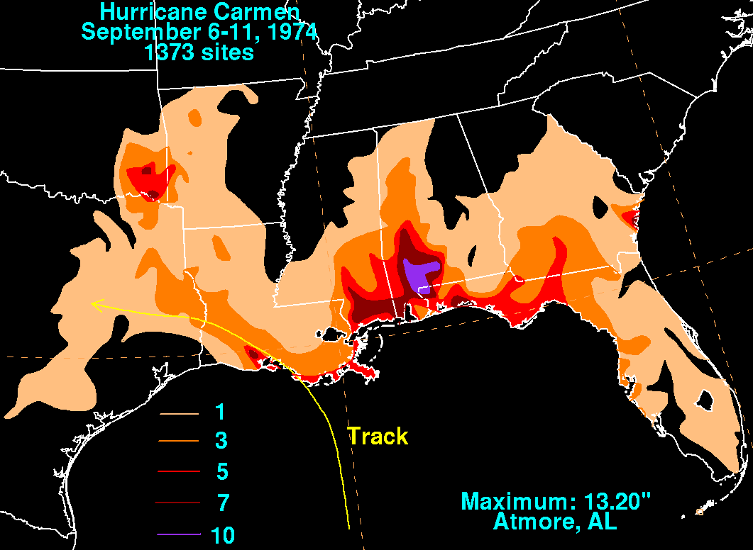
Carmen dropped moderate rainfall along its path, although the heaviest rainfall occurred well to the east of the storm's center, in southern AlabamaAlabama
Alabama is a state located in the southeastern region of the United States. It is bordered by Tennessee to the north, Georgia to the east, Florida and the Gulf of Mexico to the south, and Mississippi to the west. Alabama ranks 30th in total land area and ranks second in the size of its inland...
and the northern Florida Panhandle
Florida Panhandle
The Florida Panhandle, an informal, unofficial term for the northwestern part of Florida, is a strip of land roughly 200 miles long and 50 to 100 miles wide , lying between Alabama on the north and the west, Georgia also on the north, and the Gulf of Mexico to the south. Its eastern boundary is...
. Precipitation peaked at over 13 in (330.2 mm) in Atmore, Alabama
Atmore, Alabama
Atmore is a city in Escambia County, Alabama, United States. At the 2000 census the population was 7,676. According to the 2005 U.S. Census estimates, the city had a population of 7,530. The city was named for Mr. C.P. Atmore....
. Gusts of wind reached as high as 86 mph (138.4 km/h), and along the coast tides ran up to 6 ft (1.8 m) above normal. Over northwestern Louisiana, winds ranged from 40 mile per hour and brought down several trees. In New Orleans, despite wind gusts to 72 mph (115.9 km/h), minimal damage occurred. The hurricane's effects in Baton Rouge
Baton Rouge, Louisiana
Baton Rouge is the capital of the U.S. state of Louisiana. It is located in East Baton Rouge Parish and is the second-largest city in the state.Baton Rouge is a major industrial, petrochemical, medical, and research center of the American South...
were confined to a few downed trees and scattered debris. Since Carmen had moved ashore over uninhabited marshland, it caused far less damage than first feared. Nonetheless, tidal flooding from the Gulf of Mexico and coastal bodies of water was severe. Freshwater flooding was less extreme. In total, the storm inundated 2380500 acres (963,355 ha) of land in Louisiana, including 742300 acre (300,398.4 ha) in Terrebonne Parish
Terrebonne Parish, Louisiana
Terrebonne Parish is a parish located in the U.S. state of Louisiana. The parish seat is Houma. Its population was 111,860...
and 590000 acres (238,764.7 ha) in Plaquemines Parish
Plaquemines Parish, Louisiana
Plaquemines Parish is the parish with the most combined land and water area in the U.S. state of Louisiana. The parish seat is Pointe à la Hache...
, with flood waters.
Edwin Edwards
Edwin Washington Edwards served as the Governor of Louisiana for four terms , twice as many terms as any other Louisiana chief executive has served. Edwards was also Louisiana's first Roman Catholic governor in the 20th century...
estimated crop damage alone at $400 million, although a more recent estimate placed total agricultural damage from the hurricane at $74 million. The sugar-cane crop was crucial to the country's sugar supplies, rendering the losses "doubly bad", and sugar futures
Futures contract
In finance, a futures contract is a standardized contract between two parties to exchange a specified asset of standardized quantity and quality for a price agreed today with delivery occurring at a specified future date, the delivery date. The contracts are traded on a futures exchange...
rose drastically after the storm. Other crops damaged by Carmen included soybeans, rice, and cotton.
Tidal action along the coast had an impact on the balance of salinity in coastal marshes and water bodies. The sudden intrusion of saltwater stressed plants. Fish, shrimp and oysters also suffered ecological effects from Hurricane Carmen. Flooding on land caused some wildlife to drown. Several parks in Louisiana sustained damage, either from flooding or high winds. Losses to Grand Island
Grand Isle, Louisiana
Grand Isle is a town in Jefferson Parish, Louisiana, located on a barrier island of the same name in the Gulf of Mexico. The island is at the mouth of Barataria Bay where it meets the gulf. As of the 2000 census, the town population was 1,541; during summers, the population sometimes increases to...
State Park totaled $114,600. The oil and gas industry was also affected, and its estimated $24.7 million in losses resulted mainly from damage to equipment and offshore facilities. The storm diminished oil production by 1.4 million barrels when it shut down operations for 24 to 48 hours at various locations. Over 60,000 electric cooperative customers lost power.
The hurricane caused two fatalities in Louisiana; a utility repairman was electrocuted while working on power lines damaged by strong winds, and a motorist died in a storm-induced traffic accident. Total monetary damage was placed at $150 million in the state. Overall, the storm spawned four tornadoes. One touched down near Brandon, Mississippi
Brandon, Mississippi
Brandon is a city in Rankin County, Mississippi, United States. The population was 16,436 at the 2000 census. It is the county seat of Rankin CountyBrandon is part of the Jackson Metropolitan Statistical Area.- History :...
, destroying a barn and causing other damage. Another occurred at Kaplan, Louisiana
Kaplan, Louisiana
Kaplan is a small city in Vermilion Parish, Louisiana, United States. The population was 5,177 at the 2000 census. It is part of the Abbeville Micropolitan Statistical Area.-History:...
, injuring one person. The storm's effects in Mississippi were described as minimal and were mainly confined to minor traffic accidents during heavy precipitation. Light to moderate rainfall from the storm reached as far east as Florida and Georgia and as far west as Oklahoma and Texas.
See also
- List of Atlantic hurricanes
- List of retired Atlantic hurricane names
- List of wettest tropical cyclones in Alabama