
Phong Nha-Ke Bang
Encyclopedia
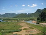
Phong Nha - Ke Bang is a national park
and UNESCO
World Heritage Site
in the Bố Trạch
and Minh Hóa
districts of central Quang Binh Province
, in north-central
Vietnam
, about 500 km south of the nation's capital, Hanoi
. The park borders the Hin Namno Nature Reserve
in the province
of Khammouan, Laos
by the west, 42 km east of South China Sea
from its borderline point. Phong Nha-Ke Bang National Park is situated in a limestone zone of 2,000 km2 in Vietnamese territory and borders another limestone zone of 2,000 km2 of Hin Namno
in Laotian
territory. The core zone of this national park covers 857.54 km2 and a buffer zone of 1,954 km2. The park was created to protect one of the world's two largest karst
regions with 300 caves and grotto
es and also protects the ecosystem
of limestone
forest of the Annamite Range
region in north central coast
of Vietnam.
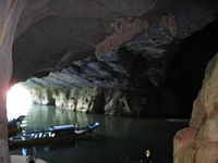
Phong Nha-Ke Bang area is noted for its cave and grotto systems as it is composed of 300 caves and grottos with a total length of about 70 km, of which only 20 have been surveyed by Vietnamese and British scientists; 17 of these are in located in the Phong Nha area and three in the Ke Bang area. After April 2009, total length of caves and grottoes are 126 km. Before discovery of Son Doong Cave
, Phong Nha held several world cave records, as it has the longest underground river, as well as the largest caverns and passageways.
The park derives it name from Phong Nha cave, the most beautiful of all, containing many fascinating rock formations, and Ke Bang forest.
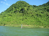
The plateau on which the park is situated is probably one of the finest and most distinctive examples of a complex karst
landform in Southeast Asia.
This national park was listed in UNESCO
's World Heritage Sites in 2003 for its geological values as defined in its criteria viii.
In April 2009, the world's largest cave Son Doong Cave
, was discovered by a team of British cave explorers of British Caving Association
.
inscriptions carved on stele
s and altars in the cave demonstrate that people had inhabited the cave long before the area was annexed by Vietnam in the Nam Tiến
or southward expansion.
In 1550, Dương Văn An
was the first Vietnamese man to write about Phong Nha cave. Phong Nha cave was depicted in 9 urns in the Citadel of the Nguyễn Dynasty in Huế
.
In 1824, Phong Nha cave was conferred the title "Diệu ứng chi thần" (Han Tu: 妙應之神) by king Minh Mạng
. It was also conferred by Nguyen kings as "Thần Hiển Linh" (Han Tu: 神顯靈).
In the late 19th century, Léopold Michel Cadière
, a French Catholic priest, conducted an expedition to explore Phong Nha cave, where he discovered Champa scripts. He proclaimed Phong Nha cave "The number one cave of Indochina". In July 1924, an English expeditionist, Barton, stated that Phong Nha cave is second to none of famous caves of Padirac
(France), Cuevas del Drach
(Spain) as far as the beauty and miracles are concerned.
In 1935, a local inhabitant accidentally discovered a beautiful cave 1 km from Phong Nha cave mouth, at an elevation of 200 m. It was called Tien Son cave (lit.: Fairy-tale cave), or Dry cave because its inside landscape is similar to fairy-tales and it has no underground river.
In 1937, the Bureau of Tourism of French Resident Superior (in Huế
) issued a brochure to introduce tourism in Quang Binh and Phong Nha Cave was included in this introduction. This tour site is ranked second in French Indochina
. Before 1990, several explorations were conducted by Vietnamese and foreign groups but the mystery of this area still remained. From 1990 on, there marked a turning point in discovering activities, from exploration to research, thus full documents for submission to UNESCO for World Natural Heritage nomination were made available.
 For the first time in 1990, Hanoi University accepted the cooperation proposal of the British Cave Research Association
. They combined efforts in exploring and researching caves and grottoes in the area comprehensively. The first exploration was conducted in 1990 by a group from the British Cave Research Association and Faculty for Geology and Geography of Hanoi University, led by Howard Limbert. They completed research of a large part of Vom Cave.
In 1992, the second exploration was conducted by a group of 12 British scientists, six professors from Hanoi University. This time, this group completed their exploration of 7,729 m of Phong Nha Cave and 13,690 m of Vom Cave and adjacent caves and grottos. In 1994, a third exploration was carried out by a group of 11 British scientists and five Vietnamese professors of Hanoi University.
In 1999 scientists from the Vietnam-Russia Tropical Centre
also conducted zoological and botanical surveys in the Ke Bang area.
From the results of these three explorations, more thorough knowledge of the cave and grotto systems in this park was made available to the Vietnamese and local government for the protection, planning, and tourism development of this park.
In 2005, scientists from the British Cave Research Association discovered a new cave and named it Paradise Cave (động Thiên Đường). The newly discovered cave was acclaimed by the British scientists as "the largest and the most beautiful cave in Phong Nha-Ke Bang area".
On June 1, 2006, the Ministry of Culture and Information of Vietnam issued a stamp collection of depicting various landscapes found in Phong Nha-Ke Bang.
In April 2009, a group of cave explorers from British Caving Association
conducted survey in this park and adjacent areas. The biggest chamber of Son Doong is over five kilometers in length, 200 meters high and 150 meters wide. With these dimensions, Son Doong overtakes Deer Cave
in Malaysia to take the title of the world's largest cave.
In this time, they also found many new caves and grottoes in the park and adjacent area.
In this survey, the cave British explorers discovered 20 new caves with total length of 56 km, including world's largest cave Son Doong.
 Phong Nha - Ke Bang National Park is located in the territories of communes (Vietnamese: xã): Tan Trach, Thuong Trach, Phuc Trach, Xuan Trach and Son Trach of Bố Trạch
district and a small part of Minh Hoa
district in the center of Quang Binh province
, around 40 km north-west of the provincial capital city of Đồng Hới. The park is bordered by Hin Namno
karst area of Khammouan Province of Laos
in the west. The road distances are about 500 km south of the capital Hanoi
and 260 km north of the port city of Da Nang
. The geographical coordinates
are 17°32′14"N 106°9′4.5"E.
The park is situated around 30 km west of South China Sea
and National Road 1A, near Ho Chi Minh Highway
and 28 km west of Hanoi-Saigon Railway and is accessed by road or waterway by boat through the estuary in South China Sea upwards. There is a small airport near the park accessible by helicopter or small aircraft (Khe Gat Airbase), an airbase used by North Vietnamese Air Force during Vietnam War
, notably in the Battle of Đồng Hới.
region, especially rare species native to this region.
The park covers a total area of 857.54 km2 which are divided into three zones, a "strictly protected zone" (648.94 km2), an "ecological recovery zone" (174.49 km2), and an "administrative service zone" (34.11 km2).
in general and Quang Binh Province
in particular, the climate in this national park is tropical, hot, and humid. The annual mean temperature is 23 to 25 °C, with a maximum of 41 °C in the summer and a minimum of 6 °C in the winter. The hottest months in this region fall from June to August, with an average temperature of 28 °C, and the coldest months from December to February with an average temperature of 18 °C. Annual rainfall is 2,000 mm to 2,500 mm, and 88% of the rainfall is from July to December. With more than 160 rainy days per year, no month is without rain. Mean annual relative humidity is 84%.
(some 400 million years ago) and so is the oldest major karst
area in Asia. It has been subject to massive tectonic changes, and comprises a series of rock types that are interbedded in complex ways. Probably as many as seven different major levels of karst development have occurred as a result of tectonic uplift and changing sea levels, thus the karst landscape of PNKB is extremely complex with high geodiversity and many geomorphic features of considerable significance. Like much of Vietnam, it has been subject to extensive tectonic change, and so the limestones of Phong Nha are inter-bedded with a number of other rocks. There is also strong evidence that sulphurous solution and hydrothermal action have played an important role in shaping the broad-scale landscape and the caves, though this has not yet been properly assessed.
Phong Nha-Ke Bang area today is a result of 5 stages of Earth's crust development and movement in this area:
regions. In comparison with 41 other world heritage sites which have karsts, Phong Nha has dissimilar geomorphic, geologic and biotic conditions. The karsts of Phong Nha can be traced back to Palaeozoic
era, 400 million years ago. This makes Phong Nha the oldest major karst in Asia. If the Hin Namno
, bordering Phong Nha on the west (in Laotian
territory) was to be combined with the national park in a continuous reserve, the combined reserve would be the largest surviving karst forest in South-east Asia (317,754 ha).
In general, there are two groups of landform
s in the Phong Nha - Kẻ Bàng area, namely non-karstic and karstic landforms. Non-karstic landforms includes three types: The middle and low dome-block mountains developed in intrusive magmatic massifs; The middle denudation-structural mountain belts developed in terrigenous rocks of Cretaceous age; and The low block-denudational mountain belts developed in other terrigenous rocks.
Karstic landforms in this area are of typical tropical karst which are divided into two groups of forms: The karstic forms on the surface including cone and tower karst, karrens, valleys and dolines, border polje, etc.; The underground karst consisting of caves.
In comparison with three other national parks listed in UNESCO's World Heritage Sites in Southeast Asia, namely Gunung Mulu National Park
in Malaysia, Puerto Princesa Subterranean River National Park
in Palawan
of the Philippines
and Lorentz National Park
in West Irian
of Indonesia
and some other karst regions in Thailand
, China, Papua New Guinea
, karst
in Phong Nha-Ke Bang is older, has more complicated geological structure; diverse and complex underground rivers.

Mounts in karst
ic area of the park rise at typical height of above 800 m constitute a continuous range along Laotian-Vietnamese borderline, of which notable summits above 1000 m are: Phu Tạo (1174 m), Co Unet (1150 m), Phu Canh (1095 m), Phu Mun (1078 m), Phu Tu En (1078 m), Phu On Chinh (1068 m), Phu Dung (1064 m), Phu Tu Ôc (1053 m), Phu Long (1015 m), Phu Ôc (1015 m), Phu Dong (1002 m). Inserting into these summits are 800–1000 m high summits of Phu Sinh (965 m), Phu Co Tri (949 m), Phu On Boi (933 m), Phu Tu (956 m), Phu Toan (905 m), Phu Phong (902 m), núi Ma Ma (835 m).
Non-karst
ic topograhical area accounts for a low percentage, distributing mainly in outer circle of limestone in the north, northeast and southeast of this national park. The height of these summits varies from 500-1000 m with the deep divisions and high sloping level from 25-30o. There are some narrow valleys along streams such as Am creek, Cha Lo creek, Chua Ngút creek and a valley along Rao Thuong river in the southernmost edge. In the north-south direction, there exists notable summits: Phu Toc Vu (1000 m), Mã Tác (1068 m), Cổ Khu (886 m), U Bò (1009 m), Co Rilata (1128 m); The highest summit in the non-karstic area and also the highest summt of this national park is Co Preu (1213 m), a summit in the southernmost edge of the park.
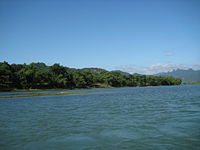
 Besides the grotto and cave systems, Phong Nha has the longest underground river. The Son
and Chay are the main rivers in this national park. Most of caves here have been shaped by Son and Chay Rivers. The Son River flows into the mouth of the Phong Nha cave and keeps on underground, where it is called as the Nam Aki River. It emerges 20 km to the south near Pu-Pha-Dam Mountain.
There are over ten spectacular streams, springs and waterfalls in Phong Nha-Ke Bang area, namely: Gió waterfall, Madame Loan waterfall, Mọc stream erupting from a limestone mount range, and Trạ Ang stream.
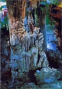
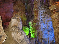
was found, Phong Nha cave was regarded by British Caving Association as the top cave in the world due to its 4 top records: the longest underground river, the highest and longest cave, broadest and most beautiful fine sand beaches inside the caves, the most spectacular stalagmites and stalactites.
In the survey conducted in April 2009, the British cave explorers discovered 20 new caves with total length of 56 km, including world's largest cave Son Doong.
According to the assessment of UNESCO
, The karst formation of Phong Nha-Ke Bang National Park has evolved since the Palaeozoic (some 400 million years ago) and so is the oldest major karst area in Asia and Phong Nha displays an impressive amount of evidence of earth's history. It is a site of very great importance for increasing our understanding of the geologic, geomorphic and geo-chronological history of the region.
s and stalagmite
s inside the cave looking like teeth), but other theorires suggest that Phong Nha is the name of a nearby village and therefore, its name has nothing to do with wind and teeth as widely explained
According to Lê Quý Đôn, Phong Nha was the former name of a nearby village.
Other theory suggests that, Phong Nha derived its name from the imagination that mounts in this region standing in line looks similar to the scene of mandarins in front of the king in royal courts, therefore, it was named Phong Nha (Han Tu: phong (峰) means "summit" and nha (衙) means "mandarin").
Other names of Phong Nha cave includes: Thầy Tiên cave, Thầy Mount, and Troóc cave.
 This cave from which the name to the whole system and the park is derived is famous for its rock formations which have been given names such as the "Lion", the "Fairy Caves", the "Royal Court", and the "Buddha
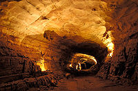
". This cave is 7729 m long, contains 14 grottos, with a 13,969 m-long underground river. The scientists have surveyed 44.5 km of grottos in this cave so far, but tourists can only penetrate to a distance of 1500 m. Phong Nha Caves, like most of the caves in this area, has been continuously shaped by the Chay River. As one gets farther into the cave, the more illusory the stalactites and stalagmites look as they glitter when bright light is shone on them. The Son River flows into the mouth of the cave and keeps flowing underground, where it is referred to as the Nam Aki River, then this river emerges at a site 20 km to the south near Pu Pha Dam Mountain. The main Phong Nha cave includes 14 chambers, connected by an underwater river that runs for 1.5 km. Secondary corridors branch off in all directions. The Outer Cave and some of the Inner Caves have roofs that tower between 25 and 40 meters above the water level. From the 14th chamber there may be other corridors leading to similarly large chambers, but this area proves more dangerous for explorers because of the ongoing erosion of the limestone of the cavern. The Shallow cave is located 800 meters from the cave mouth, where there is a spectacular landscape of sand and rock. Stalactites and stalagmites jut out like strange trees, exciting visitor's imaginations. Notable caves and grottos:
Phong Nha Cave system:
(Paradise) Cave is a newly found cave in this area. Prior to the discovery of Son Doong Cave, it was regarded as the largest and longest cave in Phong Nha-Ke Bang. Some of the most beautiful and spectacular stalactites and stalagmites in the park are found within Thien Duong. The cave was discovered by a local man in 2005 and 5 first km of this cave was explored by explorers from British Cave Research Association
in 2005, the whole 31 km was explored and publicly announced by the British cave explorers. This cave is 31 km long, longer than Phong Nha Cave
which had been considered the longest cave in this national park
. The height can reach to 100 m and 150 wide. The limestone formation is also more spectacular than that of Phong Nha Cave. The British cave explorers was impressed by the beauty of the rock formation inside the cave, they named it Thiên Đường Cave (Paradise Cave).
Access road and tourist facilities was built by Truong Thinh Group, it was opened up to tourists on 3 September 2010 with a 1.1 km path to see the beautiful formations.
(in Vietnamese: Hang Sơn Đoòng, meaning Mountain River Cave) is one of the most recently discovered caves in the national park. Found by a local man and explored and publicly announced by the British cave scientists of the British Cave Research Association
, it is regarded as the largest cave in the world.
The biggest chamber of Son Doong is over five kilometers in length, 200 meters high and 150 meters wide. With these tremendous dimensions, Son Doong overtakes Deer Cave
of Malaysia to take the title of world's largest cave. Because the fast flowing underground river in the cave deterred the explorers from going farther, they are only able to estimate the length of the cave using a flashlight. They will carry out further exploration in the near future.
The cave had been discovered by a native man in 1991, but he could not remember the way to the cave until January, 2008. From the end of March to April 14, 2009, he helped the explorers to traverse the 10 kilometer forest pass to access the cave mouth. Because of the difficulty in traversing into the cave as well as dangerous conditions in the cave, the cave will be open only to scientists in the near future.
The cave was found by a local man named Hồ-Khanh in 1991. The local jungle men were afraid of the cave for the whistling sound it makes from the underground river. However, not until 2009 was it made known to the public when a group of British scientists from the British Cave Research Association
, led by Howard and Deb Limbert, conducted a survey in Phong Nha-Ke Bang from April 10–14, 2009. Their progress was stopped by a large calcite
wall. According to Limbert, this cave is five times larger than the Phong Nha cave
, previously considered the biggest cave in Vietnam. The biggest chamber of Son Doong is over five kilometers in length, 200 meters high and 150 meters wide. With these dimensions, Son Doong overtakes Deer Cave
in Malaysia to take the title of the world's largest cave.
 The park is part of the Annamites
eco-region. By far the largest vegetation type is tropical dense moist evergreen forest on limestone under 800 m above sea level. 96.2% of this national park is covered with forest, 92.2% of which is intact primary forest. 74.7% (1104.76 km2) of the park is covered with evergreen tropical wet forest on limestone rocks at the elevation of under 800 m; 8.5% (126 km2) is evergreen tropical wet forest on limestone rocks at the elevation of above 800 m; 8.3% (122.2 km2) evergreen tropical wet forest on soil mounts at the elevation of under 800 m; evergreen tropical wet forest on limestone rocks at the elevation of under 800 m; 0.7% (10.7 km2) evergreen tropical wet forest on limestone rocks at the elevation of above 800; 1.1% impacted evergreen tropical wet forest on limestone rocks; 2.8% (42.12 km2) impacted evergreen tropical wet forest on soil mounts; 1.3% (1,925) grass, bush on limestone rocks; 2% (29.5 km2) grass, bush on soil mounts; permanent wetland forest: 1.8 km2; rattan and bamboo forest: 1.5 km2; and agricultural plants: 5.21 km2 or 0.3%. According to the results of initial surveys, the primary tropical forest in Phong Nha - Ke Bang consists of 140 families, 427 genera, and 751 species of vascular plants, of which 36 species are endangered and listed in the Vietnam's Red Data Book
.
The most common tree species in this park are Hopea sp., Sumbaviopsis albicans
, Garcinia fragraeoides, Burretionendron hsienmu, Chukrasia tabularis, Photinia aroboreum and Dysospyros saletti. Seedlings can only grow in holes and cracks in the limestone where soil has accumulated, so in general regeneration after disturbance is slow.
The forest type in this national park is dominated by evergreen
tree species with scattered deciduous trees such as Dipterocarpus kerri, Anogeissus acuminate, Pometia pinnata and Lagerstroemia calyculata
.
In this park, the dominant plant families are the Lauraceae
, Fagacaeae, Theaceae
and Rosaceae
, with some scattered gymnosperm
s such as Podocarpus imbricatus, Podocarpus neriifolius
, and Nageia fleuryi
.
In this national park, there exists a 50 km2 forest of Calocedrus macrolepis on limestone (Calocedrus rupestris) mounts with about 2,500 trees, 60,000 per km2. This is the largest forest with this tree in Vietnam. Most of the trees here are 500–600 years old. These trees are listed in group 2A (rare, precious and limited exploitation) of the official letter 3399/VPCP-NN dated 21 June 2002, an amendment to the Decree 48 by the Government of Vietnam.
Natural University, Hanoi National University, in combination with the Research Center of Phong Nha-Ke Bang National Park, has discovered 1,320 additional species in this park, of which some groups are assessed as specially rare and precious.
Biologists have discovered three rare orchid species. Orchids found here include: Paphiopedilum malipoense
, Paphiopedilum dianthum
, Paphiopedilum concolor
. In 1996 IUCN classified these orchid species in danger of extinction in the near future.
Endemic species in this national park is composed of: Burretiodendron hsienmu
, Cryptocarya lenticellata,Deutrizanthus tonkinensis, Eberhardtia tonkinensis, Heritiera macrophylla, Hopea sp., Illicium parviflorum
, Litsea baviensis, Madhuca pasquieri
, Michelia faveolata, Pelthophorum tonkinensis, Semecarpus annamensis, Sindora tonkinensis
.
 The forest is also home to 98 families, 256 genera and 381 species of vertebrates. Sixty-six animal species are listed in the Vietnam's Red Data Book
and 23 other species in the World Red Book of Endangered Species
.
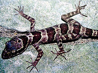
In 2005, a new species of gecko
(Lygosoma boehmeiwas) was discovered here by a group of Vietnamese biologists together with biologists working for the park, Cologne Zoo
in Germany and the Saint Petersburg Wild Zoology Institute in Russia.
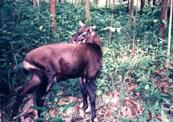
The Gaur
and one species of eel have been discovered in this park. Ten new species never seen before in Vietnam were discovered by scientists in this national park.
The Park is home to significant populations of primate
s in Vietnam, with ten species and sub-species. These include the globally vulnerable Pig-tailed Macaque
, Assamese Macaque
, Stump-tailed Macaque
and White-cheeked Crested Gibbon
(Nomascus leucogenys and Nomascus leucogenys siki). The Park is probably home to the largest population of Francois' Langur
in Vietnam, including two different forms of the species. The area is highly significant for its population of Hatinh Langur
and Black Langur. It is undoubtedly the largest population of these species in the world, and probably the only population represented in a protected area. Other endangered large mammals include the Mainland Serow
(Capricornis sumatraensis), Giant Muntjac
(Megamuntiacus vuquangensis) and possibly the Saola
(Pseudoryx nghetinhensis). The Asiatic Black Bear
(Selenarctos thibetanus) and Sun Bear
(Helarctos malayanus) are confirmed. Other smaller mammals include Sunda Pangolins (Manis javanica) and the recently discovered Striped hare, called locally 'tho van' (Nesolagus timminsii). Ten bat species listed in the IUCN List of Threatened Species have been recorded in this park.
Of the 59 recorded reptile
and amphibian
species, 18 are listed in Vietnam's Red Data Book
and 6 are listed in the IUCN Red List of Threatened Animals
. The 72 fish species include 4 species endemic to the area, including Chela quangbinhensis
.
The park is home to over 200 bird species, inclusive of several rare birds such as: Chestnut-necklaced Partridge
, Red-collared Woodpecker
, Brown Hornbill
, Sooty Babbler
and Short-tailed Scimitar-babbler
. There is good evidence for the Vietnamese Pheasant
(Lophura hatinhensis) and Imperial Pheasant
(Lophura imperialis) species at Phong Nha - Kẻ Bàng area.
An initiative survey conducted by Russian and Vietnamese scientists from Vietnam-Russia Tropical Centre
(funded by WWF
) recorded 259 butterfly species of 11 families. Almost all major butterfly taxa in Vietnam can be found in Phong Nha - Ke Bang National Park. Suong mat nang
axe heads and similar artifacts found in some of the caves. Phong Nha - Ke Bang is home to archeological and historical relics, such as an ancient hieroglyphic script of the Cham ethnic minority. In 1995, the Archeological Institute of Vietnam remarked that Phong Nha cave is probably an extremely important archeological site. This organization suggested that what remained in Bi Ky grotto may have been a Champa mosque from the 9th to 11th century. Inside Phong Nha cave, many Champa style ceramics, earthware vases with lotus-shaped ruby-colored, slight pink mouth.
In 1899, a French missioner, Léopold Cadière surveyed the customs and culture of the local inhabitants living along the Son River. In the letter to École française d'Extrême-Orient
, he stated that: "What remains here proves to be valuable for history. To keep it is to help science". In early 20th century, cave explorers and researchers from France and the UK discovered several ancient Champa and Vietnamese relics, such as altar, steles, hieroglyphic script, sculptures, stone statues, Buddha statues, and Chinese artifacts.
King Hàm Nghi
built a base for the Vietnamese resistance against the French colonialist
s in the late 19th century.
During the Vietnam War
, the caves were an impregnable major base of the North Vietnamese Army, comprising; Xuan Son Ferry, Ho Chi Minh Trail
, Road 20, Mụ Giạ, A.T.P, Trà Ang, Cà Tang, a curve road, Ve stream, Six Sisters grotto, Nine Story grotto, Nguyen Van Troi Ferry, storage depots in caves and grottos in Tuyên Hóa
, and Minh Hoa
.
In 1999, the World Conservation Union
(IUCN) conducted a field survey in January and February. At the meeting in July 1999, Evaluation Bureau concluded that Phong Nha Nature Reserve would meet with criteria I and IV as a world heritage nominee on the condition that this nature reserve was expanded to include the larger Phong Nha Ke Bang National Park with an associated fully integrated management structure. This bureau stated that the site was part of an extremely complex and ancient karst plateau with high geodiversity which also encompasses Ke Bang and Hin Namno karsts. The reserve is largely covered in tropical forest with a high level of biodiversity and endemic species. Lack of research means that the true significance of the biodiversity and geology of the area cannot be fully assessed. The evaluation bureau concluded that the nominated area on its own is not considered to meet World Heritage criteria. Nevertheless, if this nature reserve was jointly nominated with the Hin Namno karst ecosystem in Laos
, the combined site would constitute the largest surviving area of karst forest in South-east Asia and may merit World Heritage status. The Bureau decided to defer the nomination of Phong Nha Nature Reserve.
In 2000, the government of Vietnam submitted a revised nomination with a much larger area. At this time, however, the National Assembly and government of Vietnam also announced that it would be constructing the north-south Ho Chi Minh Highway and a link road between the Highway and Route 20 that bisects part of the core area of the Phong Nha Nature Reserve. The news of this road construction raised concern over its impacts on the Phong Nha Nature Reserve, and many international organization like IUCN, Flora and Fauna International called on Vietnamese government to reconsider its plan. They also advised of the negative impact of these road and construction activities on biodiversity. Due to this plan of road construction, the evaluation bureau did not proceed further consideration of nomination from Vietnamese government at that time.
The government of Vietnam provided the bureau with additional information in May 2002, announcing the decision of the Prime Minister of Vietnam
(December, 2001) on the upgrading of the Phong Nha – Ke Bang Nature Reserve to the Phong Nha – Ke Bang National Park with a total area of 857.54 km2; providing information on projects for the conservation and development of the Park and revised maps. This revised nominated site has a much smaller area than the 2000 nomination, though still relatively larger than that of 1998.
It was recognized as a world natural heritage site at the UNESCO's 27th general assembly session being held in Paris June 30–July 5, 2003. At the session, delegates from over 160 member countries of UNESCO World Heritage Convention agreed to include Phong Nha-Ke Bang park and 30 others worldwide in the list of world heritage sites. Phong Nha-Ke Bang National Park meets with criteria viii in accordance with UNESCO's appraisal scale as it displays an impressive amount of evidence of earth's history and is a site of very great importance for increasing human understanding of the geologic, geomorphic and geo-chronological history of the region.
Vietnamese and international experts believed that if Vietnam timely submits the proposal documents to UNESCO and meet this UNESCO's criteria, this national park will be recognized for a second time in 2008.
Since the recognition by UNESCO in 2003, the government of Vietnam has continued to compile scientific documentation to seek recognition of the park as a world natural heritage in terms of biodiversity in addition to geographical values. According to World Wildlife Foundation report in 2000, Phong Nha-Ke Bang National Park is one of 200 biodiversity centres of the world and one of the 60 significant sanctuaries of Vietnam. It has a unique forest type in the world: green tropical forest. The park also has 15 other types of forests.
At the final conference of the National Council for Cultural Heritage held in Vietnam in 2007, scientists attending the meeting highly praised the scientific documentation of Phong Nha-Ke Bang park. Accordingly, the park is second to no other national parks listed in UNESCO's world heritage sites as far as biodiversity is concerned.
 The park is accessible by road (National Road 1A or Ho Chi Minh Highway
450 km south of Hanoi
, 50 km north of Đồng Hới, 210 km north of Huế
); by rail at Dong Hoi Railway Station
on Hanoi-Saigon Railway; by air at Dong Hoi Airport
45 km south of the park. Tourists are served at the Tourism Service Center at Sơn Trạch
commune
of Bố Trạch District, the entrance of this center is located by Ho Chi Minh Highway
. Tourists are required to buy entrance ticket for package services, including entrance fee, boat service. Ecotourism tour (if needed) requires additional service fee. Tourists then will be transported by boat along the Son River
upstream to the Phong Nha Cave and Paradise Cave. Local tour guides can speak English, French and Mandarin Chinese.
The number of tourists has increased dramatically since the park was listed in UNESCO's World Heritage Sites.
Quang Binh Province
has invested into upgrading the Phong Nha-Ke Bang visitor site to turn it into one of Vietnam's major tourist destinations.
Multiple eco-tourist projects have been licensed for development and the area is being heavily developed by the province to turn it into a major tourist site in Vietnam. Phong Nha Ke Bang is part of a tourism promotion program called: "Middle World Heritage Road
" which includes the ancient capital of Huế
, the Champa
relics of Mỹ Sơn, the city of Hội An
, nha nhac and the Space of Gong Culture in the Central Highlands of Vietnam.
Tourist activities in Phong Nha-Ke Bang National Park are organized by local travel agencies and vary in form:
One of the adventure tour sites is boating upward on the Chay River into primitive forests, as the river becomes sinuous with several waterfalls and whirlpools until tourists arrive at Tro Mong. This tour sites have been surveyed and included in local travel agents besides cave exploration tour. In Phong Nha-Ke Bang park, there are is a 50 m-high waterfall, Chai Waterfall. There is a bull field called Ran Bo (Bull Field) because wild bulls usually comes and reproduce in mating season. There are also some interesting tourist attractions in this park like Nước Ngang (lit.: Horizontal Spring), a spring runs horizontally instead of vertically as usual; Ðá Nằm (Crouching Stone), a stone blockading a stream current; Chân Thớt (Chopping Board), a chopping-board-shaped stone. But above all, the most spectacular scene is this area is Nước Trồi (Surfacing Stream), a stream surfacing from the ground. Several streams here run for a long distance, then disappear under the ground.
Thanks to the tourism development in this national park, about 1000 local residents have jobs in tourism. The provincial Centre for Phong Nha-Ke Bang's Ecotourism and Culture currently has 248 boats, creating jobs for 500 locals. Every boat has two trained boatmen earning VND70,000 per day. This income is relatively high for peasants in this province. This centre also launched a programme in 2000 to train former loggers to work as photographers taking pictures for tourists and about 300 former loggers are now doing this.
In order to facilitate the increasing flow of tourists to the site, the Dong Hoi Airport
was constructed and put into operation in May 2008 with air link with Hanoi
's Noi Bai International Airport
and air link with Ho Chi Minh City
's Tan Son Nhat International Airport
beginning from 1 July 2009.
Phong Nha-Ke Bang, together with Ha Long Bay
and Fanxipan
of Vietnam, is listed as a candidate for 7 new world natural wonders vote. As of February 12, 2008 it ranked 10th in the voting list
In January 2009, the United States-based Los Angeles Times
listed Phong Nha-Ke Bang National Park in its recommended world's 29 destinations to visit in 2009.
A semi-wild zone of 0.18 km2, surrounded by electrical wire fence, saved for the primate species was created in this park. This project is sponsored by Zoologische Gesellschaft Frankfurt (Germany) in order to provide a sanctuary for 10 species of primates, including Trachypithecus francoisi hatinhensis, Red-shanked Douc langur or Pygathrix nemaeus nemaeus. This protection zone is suitable for primates habitat.
The increase of visitors to this park is also a problem to the park since unexpected pollution (water pollution, rubbish), human impacts on caves and grottos may cause damage to them and especially threaten biodiversity. Hunting is a significant threat to the wildlife because local people have a great consumption demand on wild meat and this has contributed to the significant decrease of species such as the wild pig, binturong
and primates. While local authorities have taken no legal action, nevertheless, some civil servants and policemen are the owners of restaurants that serve wild animal meats hunted in this national park. Phong Nha-Ke Bang National Park is currently not meaningful for protection of tiger
s, Asian Elephant
s, and wild bulls.
Rare eels like Anguilla marmorota and Anguilla bicolo have been caught and consumed in large numbers by the local residents and served as specialities in restaurants because local inhabitants believe they are "natural Viagra
".
Excessive exploitation of rare wood such as Go Mun
wood (Diospyros spp.) and Go Hue wood (Dalbergia rimosa) and oils from trees such as Cinnamomum balansea, rattan
has cause an exhaustion of these plants in many areas of the park. Bat population in caves and grottos also face disturbance by human activities.
Ho Chi Minh Highway
, Road 20 crossing the edge zone and the connection road linking these two roads crossing the core zone also contribute danger to the wildlife in this national park, especially populations of Hatinh Langur
and Black Langur. During the construction of this road, blasts and other activities kept several primates away from their regular habitat.
Due to poor management by the local government, many areas of forest in the buffer zone were cleared heavily, some completely.
Limestone in Phong Nha-Ke Bang area has been exploited for commercial purposes by local inhabitants, but the local authority has taken no countermeasures to prevent this.
The provincial government approved a 3600MW coal-fueled thermaleclectrical plant in Vĩnh Sơn village, Quảng Đông commune, Quang Trach
district, 40 km northeast of this national park. This project has deeply concerned many environmentlists as it will probably cause air and water pollution to the park.
Wildfire
in the dry season is a regular threat to the forest in this national park.
In 2007, the German government donated a further 1.8 million euros to Vietnam for protection of this park.
Fauna & Flora International donated USD 132,000 to Phong Nha-Ke Bang National Park Management Board for the protection of primates in this national park as well as in the buffer zone.
In 1998, FFI conducted a training project for the management staff of the park. The British Commission for International Development sponsored a fund for the WWF
to protect the biodiversity in the park and in the adjacent Hin Namno
Nature Reserve in Laos
. FFI also received environmental funding from the British Department for Environment, Food and Rural Affairs
to implement a campaign targeted at increasing awareness about biodiversity protection among tourists and locals.
National park
A national park is a reserve of natural, semi-natural, or developed land that a sovereign state declares or owns. Although individual nations designate their own national parks differently A national park is a reserve of natural, semi-natural, or developed land that a sovereign state declares or...
and UNESCO
UNESCO
The United Nations Educational, Scientific and Cultural Organization is a specialized agency of the United Nations...
World Heritage Site
World Heritage Site
A UNESCO World Heritage Site is a place that is listed by the UNESCO as of special cultural or physical significance...
in the Bố Trạch
Bo Trach
Bố Trạch is a rural district in Quang Binh province. The district capital is Hoan Lao townlet. Bo Trach borders capital city of Dong Hoi to the south-east and Tuyen Hoa district and Quang Trach district to the north, Quang Ninh to the south and Minh Hoa to the north-west. Bo Trach is home to...
and Minh Hóa
Minh Hoa
Minh Hóa is a district in Quang Binh province, in the North Central Coast of Vietnam. This district is composed one townlet and 15 communes : Xuân Hoá, Yên Hoá, Trung Hoá, Tân Hoá, Minh Hoá, Hồng Hoá, Hóa Tiến, Hóa Hợp, Hóa Sơn, Hóa Phúc, Hóa Thanh, Dân Hoá, Thượng Hoá, Trọng Hóa, Quy Hóa.As of...
districts of central Quang Binh Province
Quang Binh Province
Quảng Bình , formerly Tiên Bình under the reign of Le Trung Hung of the Lê Dynasty, this province was renamed Quảng Bình in 1604) is a province in the North Central Coast of Vietnam....
, in north-central
Bac Trung Bo
Bắc Trung Bộ is one of the regions of Vietnam. It consists of six provinces: Thanh Hóa, Nghệ An, Hà Tĩnh, Quảng Bình, Quảng Trị, Thừa Thiên-Huế...
Vietnam
Vietnam
Vietnam – sometimes spelled Viet Nam , officially the Socialist Republic of Vietnam – is the easternmost country on the Indochina Peninsula in Southeast Asia. It is bordered by China to the north, Laos to the northwest, Cambodia to the southwest, and the South China Sea –...
, about 500 km south of the nation's capital, Hanoi
Hanoi
Hanoi , is the capital of Vietnam and the country's second largest city. Its population in 2009 was estimated at 2.6 million for urban districts, 6.5 million for the metropolitan jurisdiction. From 1010 until 1802, it was the most important political centre of Vietnam...
. The park borders the Hin Namno Nature Reserve
Hin Namno
Hin Namno or Hin Namno National Biodiversity Conservation Area is a nature reserve in Khammouane Province, Laos. This are borders Phong Nha-Ke Bang of Vietnam to the east....
in the province
Provinces of Laos
Laos is divided into provinces and 1 prefecture plus the Vientiane Capital city municipality...
of Khammouan, Laos
Laos
Laos Lao: ສາທາລະນະລັດ ປະຊາທິປະໄຕ ປະຊາຊົນລາວ Sathalanalat Paxathipatai Paxaxon Lao, officially the Lao People's Democratic Republic, is a landlocked country in Southeast Asia, bordered by Burma and China to the northwest, Vietnam to the east, Cambodia to the south and Thailand to the west...
by the west, 42 km east of South China Sea
South China Sea
The South China Sea is a marginal sea that is part of the Pacific Ocean, encompassing an area from the Singapore and Malacca Straits to the Strait of Taiwan of around...
from its borderline point. Phong Nha-Ke Bang National Park is situated in a limestone zone of 2,000 km2 in Vietnamese territory and borders another limestone zone of 2,000 km2 of Hin Namno
Hin Namno
Hin Namno or Hin Namno National Biodiversity Conservation Area is a nature reserve in Khammouane Province, Laos. This are borders Phong Nha-Ke Bang of Vietnam to the east....
in Laotian
Laos
Laos Lao: ສາທາລະນະລັດ ປະຊາທິປະໄຕ ປະຊາຊົນລາວ Sathalanalat Paxathipatai Paxaxon Lao, officially the Lao People's Democratic Republic, is a landlocked country in Southeast Asia, bordered by Burma and China to the northwest, Vietnam to the east, Cambodia to the south and Thailand to the west...
territory. The core zone of this national park covers 857.54 km2 and a buffer zone of 1,954 km2. The park was created to protect one of the world's two largest karst
Karst topography
Karst topography is a geologic formation shaped by the dissolution of a layer or layers of soluble bedrock, usually carbonate rock such as limestone or dolomite, but has also been documented for weathering resistant rocks like quartzite given the right conditions.Due to subterranean drainage, there...
regions with 300 caves and grotto
Grotto
A grotto is any type of natural or artificial cave that is associated with modern, historic or prehistoric use by humans. When it is not an artificial garden feature, a grotto is often a small cave near water and often flooded or liable to flood at high tide...
es and also protects the ecosystem
Ecosystem
An ecosystem is a biological environment consisting of all the organisms living in a particular area, as well as all the nonliving , physical components of the environment with which the organisms interact, such as air, soil, water and sunlight....
of limestone
Limestone
Limestone is a sedimentary rock composed largely of the minerals calcite and aragonite, which are different crystal forms of calcium carbonate . Many limestones are composed from skeletal fragments of marine organisms such as coral or foraminifera....
forest of the Annamite Range
Annamite Range
The Annamite Range or the Annamese Mountains is a mountain range of eastern Indochina, which extends approximately through Laos, Vietnam, and a small area in northeast Cambodia. It is known in Vietnamese as Dãy Trường Sơn, in Lao as Xai Phou Luang , and in French as the Chaîne Annamitique...
region in north central coast
Bac Trung Bo
Bắc Trung Bộ is one of the regions of Vietnam. It consists of six provinces: Thanh Hóa, Nghệ An, Hà Tĩnh, Quảng Bình, Quảng Trị, Thừa Thiên-Huế...
of Vietnam.
Phong Nha-Ke Bang area is noted for its cave and grotto systems as it is composed of 300 caves and grottos with a total length of about 70 km, of which only 20 have been surveyed by Vietnamese and British scientists; 17 of these are in located in the Phong Nha area and three in the Ke Bang area. After April 2009, total length of caves and grottoes are 126 km. Before discovery of Son Doong Cave
Son Doong Cave
Son Doong cave is a cave in Phong Nha-Ke Bang National Park, Bo Trach District, Quang Binh Province, Vietnam. The cave is located near the Laos-Vietnam border . It has a large fast-flowing underground river inside.The cave was found by a local man named Hồ-Khanh in 1991...
, Phong Nha held several world cave records, as it has the longest underground river, as well as the largest caverns and passageways.
The park derives it name from Phong Nha cave, the most beautiful of all, containing many fascinating rock formations, and Ke Bang forest.
The plateau on which the park is situated is probably one of the finest and most distinctive examples of a complex karst
Karst topography
Karst topography is a geologic formation shaped by the dissolution of a layer or layers of soluble bedrock, usually carbonate rock such as limestone or dolomite, but has also been documented for weathering resistant rocks like quartzite given the right conditions.Due to subterranean drainage, there...
landform in Southeast Asia.
This national park was listed in UNESCO
UNESCO
The United Nations Educational, Scientific and Cultural Organization is a specialized agency of the United Nations...
's World Heritage Sites in 2003 for its geological values as defined in its criteria viii.
In April 2009, the world's largest cave Son Doong Cave
Son Doong Cave
Son Doong cave is a cave in Phong Nha-Ke Bang National Park, Bo Trach District, Quang Binh Province, Vietnam. The cave is located near the Laos-Vietnam border . It has a large fast-flowing underground river inside.The cave was found by a local man named Hồ-Khanh in 1991...
, was discovered by a team of British cave explorers of British Caving Association
British Caving Association
The British Caving Association is the governing body for caving in the United Kingdom and recognised as such by the Sports Council. Its predecessor was the National Caving Association....
.
History of exploration
ChampaChampa
The kingdom of Champa was an Indianized kingdom that controlled what is now southern and central Vietnam from approximately the 7th century through to 1832.The Cham people are remnants...
inscriptions carved on stele
Stele
A stele , also stela , is a stone or wooden slab, generally taller than it is wide, erected for funerals or commemorative purposes, most usually decorated with the names and titles of the deceased or living — inscribed, carved in relief , or painted onto the slab...
s and altars in the cave demonstrate that people had inhabited the cave long before the area was annexed by Vietnam in the Nam Tiến
Nam tiến
Nam tiến refers to the southward expansion of the territory of Vietnam from the 11th century to the mid-18th century. The territory of Vietnam was gradually expanded to the South from its original heartland in the Red River Delta...
or southward expansion.
In 1550, Dương Văn An
Duong Van An
Dương Văn An was a minister in the cabinet of Mạc Dynasty, in history of Vietnam. He was born in 1514 in Tuy Lộc Village, Lộc Thủy Commune, Lệ Thủy district, Quảng Bình province. He was the author of a famous geography-history book about châu O, Ô Châu cận lục, Hán tự: 烏州近錄...
was the first Vietnamese man to write about Phong Nha cave. Phong Nha cave was depicted in 9 urns in the Citadel of the Nguyễn Dynasty in Huế
Hue
Hue is one of the main properties of a color, defined technically , as "the degree to which a stimulus can be describedas similar to or different from stimuli that are described as red, green, blue, and yellow,"...
.
In 1824, Phong Nha cave was conferred the title "Diệu ứng chi thần" (Han Tu: 妙應之神) by king Minh Mạng
Minh Mang
Minh Mạng was the second emperor of the Nguyễn Dynasty of Vietnam, reigning from 14 February 1820 until 20 January 1841. He was a younger son of Emperor Gia Long, whose eldest son, Crown Prince Canh, had died in 1801...
. It was also conferred by Nguyen kings as "Thần Hiển Linh" (Han Tu: 神顯靈).
In the late 19th century, Léopold Michel Cadière
Léopold Michel Cadière
Père Léopold Michel Cadière is a French missionary of Paris Foreign Missions Society who wrote 250 research works about Vietnamese history, religions, customs, linguistics in early 20th century. He placed the important foundation for Vietnamese studies in 20th century. He arrived in Huế on 20...
, a French Catholic priest, conducted an expedition to explore Phong Nha cave, where he discovered Champa scripts. He proclaimed Phong Nha cave "The number one cave of Indochina". In July 1924, an English expeditionist, Barton, stated that Phong Nha cave is second to none of famous caves of Padirac
Padirac
Padirac is a commune in the Lot department in south-western France....
(France), Cuevas del Drach
Cuevas del Drach
The Coves del Drach are four great caves that are located in the island of Majorca, Balearic Islands, Spain. They are in the municipality of Manacor, near the locality of Porto Cristo. The caves extend to a depth of 25 m, reaching 2.4 km in length. The four caves, called Black Cave,...
(Spain) as far as the beauty and miracles are concerned.
In 1935, a local inhabitant accidentally discovered a beautiful cave 1 km from Phong Nha cave mouth, at an elevation of 200 m. It was called Tien Son cave (lit.: Fairy-tale cave), or Dry cave because its inside landscape is similar to fairy-tales and it has no underground river.
In 1937, the Bureau of Tourism of French Resident Superior (in Huế
Hue
Hue is one of the main properties of a color, defined technically , as "the degree to which a stimulus can be describedas similar to or different from stimuli that are described as red, green, blue, and yellow,"...
) issued a brochure to introduce tourism in Quang Binh and Phong Nha Cave was included in this introduction. This tour site is ranked second in French Indochina
French Indochina
French Indochina was part of the French colonial empire in southeast Asia. A federation of the three Vietnamese regions, Tonkin , Annam , and Cochinchina , as well as Cambodia, was formed in 1887....
. Before 1990, several explorations were conducted by Vietnamese and foreign groups but the mystery of this area still remained. From 1990 on, there marked a turning point in discovering activities, from exploration to research, thus full documents for submission to UNESCO for World Natural Heritage nomination were made available.
British Cave Research Association
The British Cave Research Association is a speleological organisation in the United Kingdom. Its object is to promote the study of caves and associated phenomena, and it attains this by supporting cave & karst research, encouraging original exploration , collecting and publishing speleological...
. They combined efforts in exploring and researching caves and grottoes in the area comprehensively. The first exploration was conducted in 1990 by a group from the British Cave Research Association and Faculty for Geology and Geography of Hanoi University, led by Howard Limbert. They completed research of a large part of Vom Cave.
In 1992, the second exploration was conducted by a group of 12 British scientists, six professors from Hanoi University. This time, this group completed their exploration of 7,729 m of Phong Nha Cave and 13,690 m of Vom Cave and adjacent caves and grottos. In 1994, a third exploration was carried out by a group of 11 British scientists and five Vietnamese professors of Hanoi University.
In 1999 scientists from the Vietnam-Russia Tropical Centre
Vietnam-Russia Tropical Centre
Vietnam-Russia Tropical Centre is a scientific research organization in Vietnam. This centre was established in 1988 by an agreement between the Ministry of National Defense and Russian Academy of Sciences...
also conducted zoological and botanical surveys in the Ke Bang area.
From the results of these three explorations, more thorough knowledge of the cave and grotto systems in this park was made available to the Vietnamese and local government for the protection, planning, and tourism development of this park.
In 2005, scientists from the British Cave Research Association discovered a new cave and named it Paradise Cave (động Thiên Đường). The newly discovered cave was acclaimed by the British scientists as "the largest and the most beautiful cave in Phong Nha-Ke Bang area".
On June 1, 2006, the Ministry of Culture and Information of Vietnam issued a stamp collection of depicting various landscapes found in Phong Nha-Ke Bang.
In April 2009, a group of cave explorers from British Caving Association
British Caving Association
The British Caving Association is the governing body for caving in the United Kingdom and recognised as such by the Sports Council. Its predecessor was the National Caving Association....
conducted survey in this park and adjacent areas. The biggest chamber of Son Doong is over five kilometers in length, 200 meters high and 150 meters wide. With these dimensions, Son Doong overtakes Deer Cave
Deer Cave
Deer Cave is located near Miri, Sarawak, Malaysian Borneo and is a show cave attraction of Gunung Mulu National Park. It was surveyed in 1961 by G.E. Wilford, of the Malaysian Geological Survey, who predicted that Mulu would yield many more caves in the future...
in Malaysia to take the title of the world's largest cave.
In this time, they also found many new caves and grottoes in the park and adjacent area.
In this survey, the cave British explorers discovered 20 new caves with total length of 56 km, including world's largest cave Son Doong.
Location
Bo Trach
Bố Trạch is a rural district in Quang Binh province. The district capital is Hoan Lao townlet. Bo Trach borders capital city of Dong Hoi to the south-east and Tuyen Hoa district and Quang Trach district to the north, Quang Ninh to the south and Minh Hoa to the north-west. Bo Trach is home to...
district and a small part of Minh Hoa
Minh Hoa
Minh Hóa is a district in Quang Binh province, in the North Central Coast of Vietnam. This district is composed one townlet and 15 communes : Xuân Hoá, Yên Hoá, Trung Hoá, Tân Hoá, Minh Hoá, Hồng Hoá, Hóa Tiến, Hóa Hợp, Hóa Sơn, Hóa Phúc, Hóa Thanh, Dân Hoá, Thượng Hoá, Trọng Hóa, Quy Hóa.As of...
district in the center of Quang Binh province
Quang Binh Province
Quảng Bình , formerly Tiên Bình under the reign of Le Trung Hung of the Lê Dynasty, this province was renamed Quảng Bình in 1604) is a province in the North Central Coast of Vietnam....
, around 40 km north-west of the provincial capital city of Đồng Hới. The park is bordered by Hin Namno
Hin Namno
Hin Namno or Hin Namno National Biodiversity Conservation Area is a nature reserve in Khammouane Province, Laos. This are borders Phong Nha-Ke Bang of Vietnam to the east....
karst area of Khammouan Province of Laos
Laos
Laos Lao: ສາທາລະນະລັດ ປະຊາທິປະໄຕ ປະຊາຊົນລາວ Sathalanalat Paxathipatai Paxaxon Lao, officially the Lao People's Democratic Republic, is a landlocked country in Southeast Asia, bordered by Burma and China to the northwest, Vietnam to the east, Cambodia to the south and Thailand to the west...
in the west. The road distances are about 500 km south of the capital Hanoi
Hanoi
Hanoi , is the capital of Vietnam and the country's second largest city. Its population in 2009 was estimated at 2.6 million for urban districts, 6.5 million for the metropolitan jurisdiction. From 1010 until 1802, it was the most important political centre of Vietnam...
and 260 km north of the port city of Da Nang
Da Nang
Đà Nẵng , occasionally Danang, is a major port city in the South Central Coast of Vietnam, on the coast of the South China Sea at the mouth of the Han River. It is the commercial and educational center of Central Vietnam; its well-sheltered, easily accessible port and its location on the path of...
. The geographical coordinates
Geographic coordinate system
A geographic coordinate system is a coordinate system that enables every location on the Earth to be specified by a set of numbers. The coordinates are often chosen such that one of the numbers represent vertical position, and two or three of the numbers represent horizontal position...
are 17°32′14"N 106°9′4.5"E.
The park is situated around 30 km west of South China Sea
South China Sea
The South China Sea is a marginal sea that is part of the Pacific Ocean, encompassing an area from the Singapore and Malacca Straits to the Strait of Taiwan of around...
and National Road 1A, near Ho Chi Minh Highway
Ho Chi Minh Highway
Ho Chi Minh Road or Ho Chi Minh Highway is a highway in Vietnam. It runs from the north to the south of Vietnam, west of National Road 1A. The highway was named after Hồ Chí Minh. The route roughly coincides with the Ho Chi Minh Trail during the Vietnam War...
and 28 km west of Hanoi-Saigon Railway and is accessed by road or waterway by boat through the estuary in South China Sea upwards. There is a small airport near the park accessible by helicopter or small aircraft (Khe Gat Airbase), an airbase used by North Vietnamese Air Force during Vietnam War
Vietnam War
The Vietnam War was a Cold War-era military conflict that occurred in Vietnam, Laos, and Cambodia from 1 November 1955 to the fall of Saigon on 30 April 1975. This war followed the First Indochina War and was fought between North Vietnam, supported by its communist allies, and the government of...
, notably in the Battle of Đồng Hới.
Park layout
Before becoming a national park, this area had been a nature reserve. The Phong Nha Nature Reserve with an area of 50 km2 was officially declared by the Vietnamese government on 9 August 1986 and was extended to 411.32 km2 by 1991. On December 12, 2001, the Vietnamese Prime Minister by Decision 189/2001 189/2001/QĐ-TTG turning then a nature reserve into a national park. The purpose of this protected area is to protect forest resources, biodiversity within the boundary of this national park and to preserve scientific values of fauna and flora in Bắc Trung BộBac Trung Bo
Bắc Trung Bộ is one of the regions of Vietnam. It consists of six provinces: Thanh Hóa, Nghệ An, Hà Tĩnh, Quảng Bình, Quảng Trị, Thừa Thiên-Huế...
region, especially rare species native to this region.
The park covers a total area of 857.54 km2 which are divided into three zones, a "strictly protected zone" (648.94 km2), an "ecological recovery zone" (174.49 km2), and an "administrative service zone" (34.11 km2).
Climate
Like Bắc Trung BộBac Trung Bo
Bắc Trung Bộ is one of the regions of Vietnam. It consists of six provinces: Thanh Hóa, Nghệ An, Hà Tĩnh, Quảng Bình, Quảng Trị, Thừa Thiên-Huế...
in general and Quang Binh Province
Quang Binh Province
Quảng Bình , formerly Tiên Bình under the reign of Le Trung Hung of the Lê Dynasty, this province was renamed Quảng Bình in 1604) is a province in the North Central Coast of Vietnam....
in particular, the climate in this national park is tropical, hot, and humid. The annual mean temperature is 23 to 25 °C, with a maximum of 41 °C in the summer and a minimum of 6 °C in the winter. The hottest months in this region fall from June to August, with an average temperature of 28 °C, and the coldest months from December to February with an average temperature of 18 °C. Annual rainfall is 2,000 mm to 2,500 mm, and 88% of the rainfall is from July to December. With more than 160 rainy days per year, no month is without rain. Mean annual relative humidity is 84%.
History of formation
The Phong Nha–Ke Bang karst has evolved since the PaleozoicPaleozoic
The Paleozoic era is the earliest of three geologic eras of the Phanerozoic eon, spanning from roughly...
(some 400 million years ago) and so is the oldest major karst
KARST
Kilometer-square Area Radio Synthesis Telescope is a Chinese telescope project to which FAST is a forerunner. KARST is a set of large spherical reflectors on karst landforms, which are bowlshaped limestone sinkholes named after the Kras region in Slovenia and Northern Italy. It will consist of...
area in Asia. It has been subject to massive tectonic changes, and comprises a series of rock types that are interbedded in complex ways. Probably as many as seven different major levels of karst development have occurred as a result of tectonic uplift and changing sea levels, thus the karst landscape of PNKB is extremely complex with high geodiversity and many geomorphic features of considerable significance. Like much of Vietnam, it has been subject to extensive tectonic change, and so the limestones of Phong Nha are inter-bedded with a number of other rocks. There is also strong evidence that sulphurous solution and hydrothermal action have played an important role in shaping the broad-scale landscape and the caves, though this has not yet been properly assessed.
Phong Nha-Ke Bang area today is a result of 5 stages of Earth's crust development and movement in this area:
- Late Ordovician - Early Silurian Stage (about 450 Ma)
- Middle-late Devonian Stage (about 340 Ma)
- Carboniferous-Permian (about 300 Ma)
- Mesozoic Orogenic stage
- Cenozoic stage.
Geological significance
Phong Nha-Ke Bang National Park is one of the world's two largest limestoneLimestone
Limestone is a sedimentary rock composed largely of the minerals calcite and aragonite, which are different crystal forms of calcium carbonate . Many limestones are composed from skeletal fragments of marine organisms such as coral or foraminifera....
regions. In comparison with 41 other world heritage sites which have karsts, Phong Nha has dissimilar geomorphic, geologic and biotic conditions. The karsts of Phong Nha can be traced back to Palaeozoic
Paleozoic
The Paleozoic era is the earliest of three geologic eras of the Phanerozoic eon, spanning from roughly...
era, 400 million years ago. This makes Phong Nha the oldest major karst in Asia. If the Hin Namno
Hin Namno
Hin Namno or Hin Namno National Biodiversity Conservation Area is a nature reserve in Khammouane Province, Laos. This are borders Phong Nha-Ke Bang of Vietnam to the east....
, bordering Phong Nha on the west (in Laotian
Laos
Laos Lao: ສາທາລະນະລັດ ປະຊາທິປະໄຕ ປະຊາຊົນລາວ Sathalanalat Paxathipatai Paxaxon Lao, officially the Lao People's Democratic Republic, is a landlocked country in Southeast Asia, bordered by Burma and China to the northwest, Vietnam to the east, Cambodia to the south and Thailand to the west...
territory) was to be combined with the national park in a continuous reserve, the combined reserve would be the largest surviving karst forest in South-east Asia (317,754 ha).
In general, there are two groups of landform
Landform
A landform or physical feature in the earth sciences and geology sub-fields, comprises a geomorphological unit, and is largely defined by its surface form and location in the landscape, as part of the terrain, and as such, is typically an element of topography...
s in the Phong Nha - Kẻ Bàng area, namely non-karstic and karstic landforms. Non-karstic landforms includes three types: The middle and low dome-block mountains developed in intrusive magmatic massifs; The middle denudation-structural mountain belts developed in terrigenous rocks of Cretaceous age; and The low block-denudational mountain belts developed in other terrigenous rocks.
Karstic landforms in this area are of typical tropical karst which are divided into two groups of forms: The karstic forms on the surface including cone and tower karst, karrens, valleys and dolines, border polje, etc.; The underground karst consisting of caves.
In comparison with three other national parks listed in UNESCO's World Heritage Sites in Southeast Asia, namely Gunung Mulu National Park
Gunung Mulu National Park
Gunung Mulu National Park near Miri, Sarawak, Malaysian Borneo, is a UNESCO World Heritage Site that encompasses incredible caves and karst formations in a mountainous equatorial rainforest setting...
in Malaysia, Puerto Princesa Subterranean River National Park
Puerto Princesa Subterranean River National Park
The Puerto Princesa Subterranean River National Park is located about north of the city centre of Puerto Princesa, Palawan, Philippines. The river also called Puerto Princesa Underground River. The national park is located in the Saint Paul Mountain Range on the northern coast of the island. It is...
in Palawan
Palawan
Palawan is an island province of the Philippines located in the MIMAROPA region or Region 4. Its capital is Puerto Princesa City, and it is the largest province in the country in terms of total area of jurisdiction. The islands of Palawan stretch from Mindoro in the northeast to Borneo in the...
of the Philippines
Philippines
The Philippines , officially known as the Republic of the Philippines , is a country in Southeast Asia in the western Pacific Ocean. To its north across the Luzon Strait lies Taiwan. West across the South China Sea sits Vietnam...
and Lorentz National Park
Lorentz National Park
Lorentz National Park is located in the Indonesian province of Papua, formerly known as Irian Jaya . With an area of 25,056 km² , it is the largest national park in South-East Asia...
in West Irian
Western New Guinea
West Papua informally refers to the Indonesian western half of the island of New Guinea and other smaller islands to its west. The region is officially administered as two provinces: Papua and West Papua. The eastern half of New Guinea is Papua New Guinea.The population of approximately 3 million...
of Indonesia
Indonesia
Indonesia , officially the Republic of Indonesia , is a country in Southeast Asia and Oceania. Indonesia is an archipelago comprising approximately 13,000 islands. It has 33 provinces with over 238 million people, and is the world's fourth most populous country. Indonesia is a republic, with an...
and some other karst regions in Thailand
Thailand
Thailand , officially the Kingdom of Thailand , formerly known as Siam , is a country located at the centre of the Indochina peninsula and Southeast Asia. It is bordered to the north by Burma and Laos, to the east by Laos and Cambodia, to the south by the Gulf of Thailand and Malaysia, and to the...
, China, Papua New Guinea
Papua New Guinea
Papua New Guinea , officially the Independent State of Papua New Guinea, is a country in Oceania, occupying the eastern half of the island of New Guinea and numerous offshore islands...
, karst
Karst topography
Karst topography is a geologic formation shaped by the dissolution of a layer or layers of soluble bedrock, usually carbonate rock such as limestone or dolomite, but has also been documented for weathering resistant rocks like quartzite given the right conditions.Due to subterranean drainage, there...
in Phong Nha-Ke Bang is older, has more complicated geological structure; diverse and complex underground rivers.
Mounts and summits
Phong Nha - Ke Bang also contains two dozens of mountain peaks with over 1,000 metres in height. Noteworthy peaks are the Peak Co Rilata with ta height of 1,128 m and the Peak Co Preu with a height of 1,213 m.Mounts in karst
Karst topography
Karst topography is a geologic formation shaped by the dissolution of a layer or layers of soluble bedrock, usually carbonate rock such as limestone or dolomite, but has also been documented for weathering resistant rocks like quartzite given the right conditions.Due to subterranean drainage, there...
ic area of the park rise at typical height of above 800 m constitute a continuous range along Laotian-Vietnamese borderline, of which notable summits above 1000 m are: Phu Tạo (1174 m), Co Unet (1150 m), Phu Canh (1095 m), Phu Mun (1078 m), Phu Tu En (1078 m), Phu On Chinh (1068 m), Phu Dung (1064 m), Phu Tu Ôc (1053 m), Phu Long (1015 m), Phu Ôc (1015 m), Phu Dong (1002 m). Inserting into these summits are 800–1000 m high summits of Phu Sinh (965 m), Phu Co Tri (949 m), Phu On Boi (933 m), Phu Tu (956 m), Phu Toan (905 m), Phu Phong (902 m), núi Ma Ma (835 m).
Non-karst
Karst topography
Karst topography is a geologic formation shaped by the dissolution of a layer or layers of soluble bedrock, usually carbonate rock such as limestone or dolomite, but has also been documented for weathering resistant rocks like quartzite given the right conditions.Due to subterranean drainage, there...
ic topograhical area accounts for a low percentage, distributing mainly in outer circle of limestone in the north, northeast and southeast of this national park. The height of these summits varies from 500-1000 m with the deep divisions and high sloping level from 25-30o. There are some narrow valleys along streams such as Am creek, Cha Lo creek, Chua Ngút creek and a valley along Rao Thuong river in the southernmost edge. In the north-south direction, there exists notable summits: Phu Toc Vu (1000 m), Mã Tác (1068 m), Cổ Khu (886 m), U Bò (1009 m), Co Rilata (1128 m); The highest summit in the non-karstic area and also the highest summt of this national park is Co Preu (1213 m), a summit in the southernmost edge of the park.
Rivers and streams
Son River (Vietnam)
Son River or Troc River is a tributary of Gianh River in Quang Binh Province, Bac Trung Bo, Vietnam. This river runs in the territory of Quang Binh Province. The upstream of this river with the length of 7729 m runs underground in limestone mountains of Phong Nha-Ke Bang National Park.....
and Chay are the main rivers in this national park. Most of caves here have been shaped by Son and Chay Rivers. The Son River flows into the mouth of the Phong Nha cave and keeps on underground, where it is called as the Nam Aki River. It emerges 20 km to the south near Pu-Pha-Dam Mountain.
There are over ten spectacular streams, springs and waterfalls in Phong Nha-Ke Bang area, namely: Gió waterfall, Madame Loan waterfall, Mọc stream erupting from a limestone mount range, and Trạ Ang stream.
Cave and grottoes
Phong Nha-Ke Bang is home to the largest cave in the world and covers 300 different grottoes and caves. Before Son Doong CaveSon Doong Cave
Son Doong cave is a cave in Phong Nha-Ke Bang National Park, Bo Trach District, Quang Binh Province, Vietnam. The cave is located near the Laos-Vietnam border . It has a large fast-flowing underground river inside.The cave was found by a local man named Hồ-Khanh in 1991...
was found, Phong Nha cave was regarded by British Caving Association as the top cave in the world due to its 4 top records: the longest underground river, the highest and longest cave, broadest and most beautiful fine sand beaches inside the caves, the most spectacular stalagmites and stalactites.
In the survey conducted in April 2009, the British cave explorers discovered 20 new caves with total length of 56 km, including world's largest cave Son Doong.
According to the assessment of UNESCO
UNESCO
The United Nations Educational, Scientific and Cultural Organization is a specialized agency of the United Nations...
, The karst formation of Phong Nha-Ke Bang National Park has evolved since the Palaeozoic (some 400 million years ago) and so is the oldest major karst area in Asia and Phong Nha displays an impressive amount of evidence of earth's history. It is a site of very great importance for increasing our understanding of the geologic, geomorphic and geo-chronological history of the region.
Etymology
The name Phong Nha-Ke Bang includes Phong Nha cave and Ke Bang limestone forest. Phong Nha is widely explained as originating from Hán tự: 风牙, which means wind-tooth (wind flowing from the cave and stalactiteStalactite
A stalactite , "to drip", and meaning "that which drips") is a type of speleothem that hangs from the ceiling of limestone caves. It is a type of dripstone...
s and stalagmite
Stalagmite
A stalagmite is a type of speleothem that rises from the floor of a limestone cave due to the dripping of mineralized solutions and the deposition of calcium carbonate. This stalagmite formation occurs only under certain pH conditions within the underground cavern. The corresponding formation on...
s inside the cave looking like teeth), but other theorires suggest that Phong Nha is the name of a nearby village and therefore, its name has nothing to do with wind and teeth as widely explained
According to Lê Quý Đôn, Phong Nha was the former name of a nearby village.
Other theory suggests that, Phong Nha derived its name from the imagination that mounts in this region standing in line looks similar to the scene of mandarins in front of the king in royal courts, therefore, it was named Phong Nha (Han Tu: phong (峰) means "summit" and nha (衙) means "mandarin").
Other names of Phong Nha cave includes: Thầy Tiên cave, Thầy Mount, and Troóc cave.
The Phong Nha cave
Buddharupa
Buddharūpa is the Sanskrit and Pali term used in Buddhism for statues or models of the Buddha.-Commonalities:...
". This cave is 7729 m long, contains 14 grottos, with a 13,969 m-long underground river. The scientists have surveyed 44.5 km of grottos in this cave so far, but tourists can only penetrate to a distance of 1500 m. Phong Nha Caves, like most of the caves in this area, has been continuously shaped by the Chay River. As one gets farther into the cave, the more illusory the stalactites and stalagmites look as they glitter when bright light is shone on them. The Son River flows into the mouth of the cave and keeps flowing underground, where it is referred to as the Nam Aki River, then this river emerges at a site 20 km to the south near Pu Pha Dam Mountain. The main Phong Nha cave includes 14 chambers, connected by an underwater river that runs for 1.5 km. Secondary corridors branch off in all directions. The Outer Cave and some of the Inner Caves have roofs that tower between 25 and 40 meters above the water level. From the 14th chamber there may be other corridors leading to similarly large chambers, but this area proves more dangerous for explorers because of the ongoing erosion of the limestone of the cavern. The Shallow cave is located 800 meters from the cave mouth, where there is a spectacular landscape of sand and rock. Stalactites and stalagmites jut out like strange trees, exciting visitor's imaginations. Notable caves and grottos:
Phong Nha Cave system:
- Dark Grotto (Hang Tối): located upstream of Son River running to the branch of Chay River on the left. This cave is 5,258 m long and with a height of 83 m. The entry is high and wide with heavy forest around the cave mouth.
- E Grotto (Hang E): a 736 m-long grotto accessible by Ho Chi Minh TrailHo Chi Minh trailThe Ho Chi Minh trail was a logistical system that ran from the Democratic Republic of Vietnam to the Republic of Vietnam through the neighboring kingdoms of Laos and Cambodia...
. - Cha An Grotto (Hang Chà An): a 667 m-long grotto, with the width of 15 m.
- Thung Grotto (Hang Thung): This grotto has an underground river of 3351 m, with the height in some part exceed 133 . This river receives water resources from Rao Thuong.
- En Grotto (Hang Én): a 1645 m long, 78.6 m high grotto. The grotto is wide, there is fine sand field inside. This grotto is the habitat of thousands of sparrows.
- Khe Tien Grotto (Hang Khe Tiên): located south of Phong Nha, this grotto is 520 m long.
- Khe Ry Grotto (Hang Khe Ry): located south of Phong Nha. The grotto is where the stream Khe Ry (a 13.817 km or 8.585 mi (13.8 km) long stream at the elevation of 120 m, originating from a mount 1300 m high) runs out.
- Khe Thi Grotto (Hang Khe Thi): The Khe Thi stream originating from the mount and runs underground at this grotto.
Vom Cave systems
- Vom Grotto (Hang Vòm): a 15.05 km long, 145 m high grotto with several underground rivers, pools. This grotto features several spectacular stalagmite and stalactites. In the recent exploring of British Cave Research Association, the scientists have found an abyss in Vom Grotto named Tang hole with the deep of over 255m. This hole is the deepest hole in Vietnam.
- Dai Cao Grotto (Hang Đai Cao): this grotto is a connection of Vom Grotto. This grotto is 1645 m long, 28 m high..
- Duot Grotto (Hang Duột): This is a connection of Dai Cao Grotto with the length of 3.927 km and height of 45 m. There are some fine sand fields inside.
- Ca Grotto (Hang Cá): a 1,500 m long, 62 m high grotto.
- Ho Grotto (Hang Hổ): A connection of Ca Grotto with the length of 1,616 m and the height of 46 m
- Over Grotto (Hang Over): a 3,244 m long, 103 m high grotto, with the width from 30–50 m.
- Pygmy Grotto (Hang Pygmy): This 845 m long grotto has several streams falling from mounts.
- Ruc Caroong Grotto (Hang Rục Caroòng): This the habitat of Arem ethnic group. They live in the caves, grottos and on hunting, harvesting natural products.
Tien Son Cave
Tien Son cave is another beautiful cave in Phong Nha-Ke Bang area. Tien Son cave was discovered by a local inhabitant by accident in 1935. It is located in Son Trach Commune, Bố Trạch District. The entry mouth of Tien Son is 1 km from Phong Nha cave, at an altutude of 200 m. This cave is 980 m in length. A 10 m deep hole is situated 400 m from the entry mouth, then a 500 m long underground cave, dangerous for tourists and therefore is open to professional expeditionists only. Like Phong Nha cave, this cave features spectacular stalactites and stalagmites shaped like several fairy-tales. Stalactite and stalagmite columns and walls here create strange sounds like that of gong and drum if they are knocked with the hand. According to British cave scientists, Tien Son cave was created tens of million years ago when a water current holed this limestone mount in Ke Bang. Following a series of landforms and movement of rocks, this mass was levered or lowered, blocking the current and creating what is now Tien Son cave while the underground river redirected its current to Phong Nha cave. Although Phong Nha and Tien Son caves are located next to each other, there are no linking grottos between them.Thien Duong Cave
Thien DuongThien Duong Cave
Thiên Đường Cave is a cave in Phong Nha-Ke Bang National Park, UNESCO's World Heritage Site, 60 km northwest of Đồng Hới city....
(Paradise) Cave is a newly found cave in this area. Prior to the discovery of Son Doong Cave, it was regarded as the largest and longest cave in Phong Nha-Ke Bang. Some of the most beautiful and spectacular stalactites and stalagmites in the park are found within Thien Duong. The cave was discovered by a local man in 2005 and 5 first km of this cave was explored by explorers from British Cave Research Association
British Cave Research Association
The British Cave Research Association is a speleological organisation in the United Kingdom. Its object is to promote the study of caves and associated phenomena, and it attains this by supporting cave & karst research, encouraging original exploration , collecting and publishing speleological...
in 2005, the whole 31 km was explored and publicly announced by the British cave explorers. This cave is 31 km long, longer than Phong Nha Cave
Phong Nha cave
Phong Nha Cave is a cave in Phong Nha-Ke Bang National Park, a UNESCO World Heritage Site in Quang Binh Province, Vietnam. It is 7729 meters long and contains 14 grottos, as well as a 13,969 meter underground river. While scientists have surveyed it to a depth of 44.5 kilometers, tourists are only...
which had been considered the longest cave in this national park
National park
A national park is a reserve of natural, semi-natural, or developed land that a sovereign state declares or owns. Although individual nations designate their own national parks differently A national park is a reserve of natural, semi-natural, or developed land that a sovereign state declares or...
. The height can reach to 100 m and 150 wide. The limestone formation is also more spectacular than that of Phong Nha Cave. The British cave explorers was impressed by the beauty of the rock formation inside the cave, they named it Thiên Đường Cave (Paradise Cave).
Access road and tourist facilities was built by Truong Thinh Group, it was opened up to tourists on 3 September 2010 with a 1.1 km path to see the beautiful formations.
Son Doong Cave
Son Doong CaveSon Doong Cave
Son Doong cave is a cave in Phong Nha-Ke Bang National Park, Bo Trach District, Quang Binh Province, Vietnam. The cave is located near the Laos-Vietnam border . It has a large fast-flowing underground river inside.The cave was found by a local man named Hồ-Khanh in 1991...
(in Vietnamese: Hang Sơn Đoòng, meaning Mountain River Cave) is one of the most recently discovered caves in the national park. Found by a local man and explored and publicly announced by the British cave scientists of the British Cave Research Association
British Cave Research Association
The British Cave Research Association is a speleological organisation in the United Kingdom. Its object is to promote the study of caves and associated phenomena, and it attains this by supporting cave & karst research, encouraging original exploration , collecting and publishing speleological...
, it is regarded as the largest cave in the world.
The biggest chamber of Son Doong is over five kilometers in length, 200 meters high and 150 meters wide. With these tremendous dimensions, Son Doong overtakes Deer Cave
Deer Cave
Deer Cave is located near Miri, Sarawak, Malaysian Borneo and is a show cave attraction of Gunung Mulu National Park. It was surveyed in 1961 by G.E. Wilford, of the Malaysian Geological Survey, who predicted that Mulu would yield many more caves in the future...
of Malaysia to take the title of world's largest cave. Because the fast flowing underground river in the cave deterred the explorers from going farther, they are only able to estimate the length of the cave using a flashlight. They will carry out further exploration in the near future.
The cave had been discovered by a native man in 1991, but he could not remember the way to the cave until January, 2008. From the end of March to April 14, 2009, he helped the explorers to traverse the 10 kilometer forest pass to access the cave mouth. Because of the difficulty in traversing into the cave as well as dangerous conditions in the cave, the cave will be open only to scientists in the near future.
The cave was found by a local man named Hồ-Khanh in 1991. The local jungle men were afraid of the cave for the whistling sound it makes from the underground river. However, not until 2009 was it made known to the public when a group of British scientists from the British Cave Research Association
British Cave Research Association
The British Cave Research Association is a speleological organisation in the United Kingdom. Its object is to promote the study of caves and associated phenomena, and it attains this by supporting cave & karst research, encouraging original exploration , collecting and publishing speleological...
, led by Howard and Deb Limbert, conducted a survey in Phong Nha-Ke Bang from April 10–14, 2009. Their progress was stopped by a large calcite
Calcite
Calcite is a carbonate mineral and the most stable polymorph of calcium carbonate . The other polymorphs are the minerals aragonite and vaterite. Aragonite will change to calcite at 380-470°C, and vaterite is even less stable.-Properties:...
wall. According to Limbert, this cave is five times larger than the Phong Nha cave
Phong Nha cave
Phong Nha Cave is a cave in Phong Nha-Ke Bang National Park, a UNESCO World Heritage Site in Quang Binh Province, Vietnam. It is 7729 meters long and contains 14 grottos, as well as a 13,969 meter underground river. While scientists have surveyed it to a depth of 44.5 kilometers, tourists are only...
, previously considered the biggest cave in Vietnam. The biggest chamber of Son Doong is over five kilometers in length, 200 meters high and 150 meters wide. With these dimensions, Son Doong overtakes Deer Cave
Deer Cave
Deer Cave is located near Miri, Sarawak, Malaysian Borneo and is a show cave attraction of Gunung Mulu National Park. It was surveyed in 1961 by G.E. Wilford, of the Malaysian Geological Survey, who predicted that Mulu would yield many more caves in the future...
in Malaysia to take the title of the world's largest cave.
Florae
Annamite Range
The Annamite Range or the Annamese Mountains is a mountain range of eastern Indochina, which extends approximately through Laos, Vietnam, and a small area in northeast Cambodia. It is known in Vietnamese as Dãy Trường Sơn, in Lao as Xai Phou Luang , and in French as the Chaîne Annamitique...
eco-region. By far the largest vegetation type is tropical dense moist evergreen forest on limestone under 800 m above sea level. 96.2% of this national park is covered with forest, 92.2% of which is intact primary forest. 74.7% (1104.76 km2) of the park is covered with evergreen tropical wet forest on limestone rocks at the elevation of under 800 m; 8.5% (126 km2) is evergreen tropical wet forest on limestone rocks at the elevation of above 800 m; 8.3% (122.2 km2) evergreen tropical wet forest on soil mounts at the elevation of under 800 m; evergreen tropical wet forest on limestone rocks at the elevation of under 800 m; 0.7% (10.7 km2) evergreen tropical wet forest on limestone rocks at the elevation of above 800; 1.1% impacted evergreen tropical wet forest on limestone rocks; 2.8% (42.12 km2) impacted evergreen tropical wet forest on soil mounts; 1.3% (1,925) grass, bush on limestone rocks; 2% (29.5 km2) grass, bush on soil mounts; permanent wetland forest: 1.8 km2; rattan and bamboo forest: 1.5 km2; and agricultural plants: 5.21 km2 or 0.3%. According to the results of initial surveys, the primary tropical forest in Phong Nha - Ke Bang consists of 140 families, 427 genera, and 751 species of vascular plants, of which 36 species are endangered and listed in the Vietnam's Red Data Book
Vietnam's Red Data Book
Vietnam's Red Data Book is a list of rare and endangered species of fauna and flora native to Vietnam. This is the important legal basis for relating governmental regulations for the protection of biodiversity and wildlife in Vietnam. Criteria for this book are set forth on the basis of those...
.
The most common tree species in this park are Hopea sp., Sumbaviopsis albicans
Sumbaviopsis albicans
Sumbaviopsis albicans is a plant species of the family Euphorbiaceae and the sole member of the genus Sumbaviopsis.-Synonyms:The genus is also known as:*Adisa Steud.*Adisca Blume...
, Garcinia fragraeoides, Burretionendron hsienmu, Chukrasia tabularis, Photinia aroboreum and Dysospyros saletti. Seedlings can only grow in holes and cracks in the limestone where soil has accumulated, so in general regeneration after disturbance is slow.
The forest type in this national park is dominated by evergreen
Evergreen
In botany, an evergreen plant is a plant that has leaves in all seasons. This contrasts with deciduous plants, which completely lose their foliage during the winter or dry season.There are many different kinds of evergreen plants, both trees and shrubs...
tree species with scattered deciduous trees such as Dipterocarpus kerri, Anogeissus acuminate, Pometia pinnata and Lagerstroemia calyculata
Lagerstroemia calyculata
Lagerstroemia calyculata can be translated from the Vietnamese name as the "guava crape myrtle" ; the name is derived from its very characteristic mottled flaky bark. It is a species of flowering plant in the Lythraceae family and found in Southeast Asia and Oceania.It is a medium-sized tree...
.
In this park, the dominant plant families are the Lauraceae
Lauraceae
The Lauraceae or Laurel family comprises a group of flowering plants included in the order Laurales. The family contains about 55 genera and over 3500, perhaps as many as 4000, species world-wide, mostly from warm or tropical regions, especially Southeast Asia and South America...
, Fagacaeae, Theaceae
Theaceae
The Theaceae is a family of flowering plants, composed of shrubs and trees. Some botanists include the family Ternstroemiaceae within the Theaceae while others do not...
and Rosaceae
Rosaceae
Rosaceae are a medium-sized family of flowering plants, including about 2830 species in 95 genera. The name is derived from the type genus Rosa. Among the largest genera are Alchemilla , Sorbus , Crataegus , Cotoneaster , and Rubus...
, with some scattered gymnosperm
Gymnosperm
The gymnosperms are a group of seed-bearing plants that includes conifers, cycads, Ginkgo, and Gnetales. The term "gymnosperm" comes from the Greek word gymnospermos , meaning "naked seeds", after the unenclosed condition of their seeds...
s such as Podocarpus imbricatus, Podocarpus neriifolius
Podocarpus neriifolius
Podocarpus neriifolius is a species of conifer in the Podocarpaceae family.It is found in Brunei, Cambodia, China, Fiji, India, Indonesia, Laos, Malaysia, Myanmar, Nepal, Papua New Guinea, the Philippines, Solomon Islands, Thailand, and Vietnam....
, and Nageia fleuryi
Nageia fleuryi
Nageia fleuryi is a species of conifer in the Podocarpaceae family.It is tree 15-25 m tall, with pyramidal crown, found in Cambodia, China, Laos, and Vietnam.-Source:* Conifer Specialist Group 2000. . Downloaded on 10 July 2007....
.
In this national park, there exists a 50 km2 forest of Calocedrus macrolepis on limestone (Calocedrus rupestris) mounts with about 2,500 trees, 60,000 per km2. This is the largest forest with this tree in Vietnam. Most of the trees here are 500–600 years old. These trees are listed in group 2A (rare, precious and limited exploitation) of the official letter 3399/VPCP-NN dated 21 June 2002, an amendment to the Decree 48 by the Government of Vietnam.
Natural University, Hanoi National University, in combination with the Research Center of Phong Nha-Ke Bang National Park, has discovered 1,320 additional species in this park, of which some groups are assessed as specially rare and precious.
Biologists have discovered three rare orchid species. Orchids found here include: Paphiopedilum malipoense
Paphiopedilum malipoense
Paphiopedilum malipoense, described in 1984, is a species of orchid commonly known as the Jade Slipper Orchid. This hemicryptophyte plant starts blooming in the spring time and has one flower per inflorescence. The plant grows in intermediate to cool conditions...
, Paphiopedilum dianthum
Paphiopedilum dianthum
Paphiopedilum dianthum is a species of plant in the Orchidaceae family. It is endemic to southeastern Yunnan, southwestern Guizhou and western Guangxi in China.- Source :* China Plant Specialist Group 2004. . Downloaded on 23 August 2007....
, Paphiopedilum concolor
Paphiopedilum concolor
Paphiopedilum concolor is a small terrestrial orchid described in 1984. It has dark green and grey-green mottled leaves, up to 6 inches long by 1½ inches wide...
. In 1996 IUCN classified these orchid species in danger of extinction in the near future.
Endemic species in this national park is composed of: Burretiodendron hsienmu
Burretiodendron hsienmu
Burretiodendron hsienmu is a species of flowering plant in the Tiliaceae family.It is found in Vietnam and China.It is threatened by habitat loss.-References:* Sun, W. 1998. . Downloaded on 19 July 2007....
, Cryptocarya lenticellata,Deutrizanthus tonkinensis, Eberhardtia tonkinensis, Heritiera macrophylla, Hopea sp., Illicium parviflorum
Illicium parviflorum
Illicium parviflorum, commonly known as yellow anise, is an aromatic evergreen tree or shrub common to the southeastern United States, especially around the states of Florida and Georgia. It is in the same genus as the star anise - Illicium verum, which is commonly used and sold as a spice...
, Litsea baviensis, Madhuca pasquieri
Madhuca pasquieri
Madhuca pasquieri is a species of plant in the Sapotaceae family. It is found in China and Vietnam. It is threatened by habitat loss.-Source:* World Conservation Monitoring Centre 1998. . Downloaded on 22 August 2007....
, Michelia faveolata, Pelthophorum tonkinensis, Semecarpus annamensis, Sindora tonkinensis
Sindora tonkinensis
Sindora tonkinensis is a species of legume in the Fabaceae family.It is found in Cambodia and Vietnam.It is threatened by habitat loss.-Source:* World Conservation Monitoring Centre 1998. . Downloaded on 10 July 2007....
.
Faunae
Vietnam's Red Data Book
Vietnam's Red Data Book is a list of rare and endangered species of fauna and flora native to Vietnam. This is the important legal basis for relating governmental regulations for the protection of biodiversity and wildlife in Vietnam. Criteria for this book are set forth on the basis of those...
and 23 other species in the World Red Book of Endangered Species
IUCN Red List
The IUCN Red List of Threatened Species , founded in 1963, is the world's most comprehensive inventory of the global conservation status of biological species. The International Union for Conservation of Nature is the world's main authority on the conservation status of species...
.
In 2005, a new species of gecko
Gecko
Geckos are lizards belonging to the infraorder Gekkota, found in warm climates throughout the world. They range from 1.6 cm to 60 cm....
(Lygosoma boehmeiwas) was discovered here by a group of Vietnamese biologists together with biologists working for the park, Cologne Zoo
Cologne Zoological Garden
The Aktiengesellschaft Cologne Zoological Garden is the zoo of Cologne, Germany. It features over 7,000 animals of more than 700 species on more than 20 hectares...
in Germany and the Saint Petersburg Wild Zoology Institute in Russia.
The Gaur
Gaur
The gaur , also called Indian bison, is a large bovine native to South Asia and Southeast Asia. The species is listed as vulnerable on the IUCN Red List since 1986 as the population decline in parts of the species' range is likely to be well over 70% over the last three generations...
and one species of eel have been discovered in this park. Ten new species never seen before in Vietnam were discovered by scientists in this national park.
The Park is home to significant populations of primate
Primate
A primate is a mammal of the order Primates , which contains prosimians and simians. Primates arose from ancestors that lived in the trees of tropical forests; many primate characteristics represent adaptations to life in this challenging three-dimensional environment...
s in Vietnam, with ten species and sub-species. These include the globally vulnerable Pig-tailed Macaque
Pig-tailed macaque
The pig-tailed macaques are two macaque sister species. They look almost identical and are best distinguished by their parapatric ranges:* Northern Pig-tailed Macaque, Macaca leonina...
, Assamese Macaque
Assam Macaque
The Assam macaque is a macaque of the Old World monkey family native to South and Southeast Asia. Since 2008, the species is listed as Near Threatened by IUCN, as it is experiencing significant declines due to hunting, habitat degradation and fragmentation.- Characteristics :The Assam macaque has...
, Stump-tailed Macaque
Stump-tailed Macaque
The stump-tailed macaque , also called the bear macaque, is a species of macaque found in Southern Asia. In India, it is found in south of the Brahmaputra river, in northeastern part of the country.Its range in India extends from Assam and Meghalaya to eastern Aruanchal Pradesh, Nagaland, Manipur,...
and White-cheeked Crested Gibbon
White-cheeked Crested Gibbon
The northern white-cheeked gibbon is a species of gibbon native to Vietnam, Laos, and the Yunnan province of China. It is closely related to the southern white-cheeked gibbon , with which it was previously considered conspecific. The females of the two species are virtually indistinguishable in...
(Nomascus leucogenys and Nomascus leucogenys siki). The Park is probably home to the largest population of Francois' Langur
Francois' Langur
Francois' langur or Francois' leaf monkey is a species of lutung and the type species of its species group. Francois' langur belongs to the Colobinae subfamily, Cercopithecidae family, in the Primates order...
in Vietnam, including two different forms of the species. The area is highly significant for its population of Hatinh Langur
Hatinh Langur
The Hatinh langur is a highly threatened Old World monkey found in limestone forests in Vietnam, primarily in the Quang Binh Province. A recent survey discovered a small population living in the Quang Tri Province. Contrary to its name, it is not known from the Ha Tinh Province...
and Black Langur. It is undoubtedly the largest population of these species in the world, and probably the only population represented in a protected area. Other endangered large mammals include the Mainland Serow
Mainland Serow
The Mainland Serow is a species of goat antelope native to China and Southeast Asia. The name "mainland serow" was formerly referring to Capricornis sumatraensis, which used to be the scientific name for all serows in the mainland and Sumatra when they were all considered to be the same species...
(Capricornis sumatraensis), Giant Muntjac
Giant muntjac
The Giant Muntjac sometimes referred to as the Large-Antlered Muntjac is a species of muntjac deer. It is the largest muntjac species and was discovered in 1994 in Vu Quang, Ha Tinh province of Vietnam and in central Laos...
(Megamuntiacus vuquangensis) and possibly the Saola
Saola
The Saola, Vu Quang ox or Asian unicorn, also, infrequently, Vu Quang bovid , one of the world's rarest mammals, is a forest-dwelling bovine found only in the Annamite Range of Vietnam and Laos...
(Pseudoryx nghetinhensis). The Asiatic Black Bear
Asiatic Black Bear
The Asian black bear , also known as the moon bear or white-chested bear is a medium-sized species of bear, largely adapted for arboreal life, which occurs through much of southern Asia, Korea, northeastern China, the Russian far east and Honshū and Shikoku islands of Japan...
(Selenarctos thibetanus) and Sun Bear
Sun Bear
The sun bear , sometimes known as the honey bear, is a bear found primarily in the tropical rainforests of Southeast Asia; North-East India, Bangladesh, Myanmar, Thailand, Laos, Cambodia, Vietnam, Southern China, Peninsular Malaysia, and the islands of Sumatra and Borneo.-Description:The sun bear...
(Helarctos malayanus) are confirmed. Other smaller mammals include Sunda Pangolins (Manis javanica) and the recently discovered Striped hare, called locally 'tho van' (Nesolagus timminsii). Ten bat species listed in the IUCN List of Threatened Species have been recorded in this park.
Of the 59 recorded reptile
Reptile
Reptiles are members of a class of air-breathing, ectothermic vertebrates which are characterized by laying shelled eggs , and having skin covered in scales and/or scutes. They are tetrapods, either having four limbs or being descended from four-limbed ancestors...
and amphibian
Amphibian
Amphibians , are a class of vertebrate animals including animals such as toads, frogs, caecilians, and salamanders. They are characterized as non-amniote ectothermic tetrapods...
species, 18 are listed in Vietnam's Red Data Book
Vietnam's Red Data Book
Vietnam's Red Data Book is a list of rare and endangered species of fauna and flora native to Vietnam. This is the important legal basis for relating governmental regulations for the protection of biodiversity and wildlife in Vietnam. Criteria for this book are set forth on the basis of those...
and 6 are listed in the IUCN Red List of Threatened Animals
IUCN Red List
The IUCN Red List of Threatened Species , founded in 1963, is the world's most comprehensive inventory of the global conservation status of biological species. The International Union for Conservation of Nature is the world's main authority on the conservation status of species...
. The 72 fish species include 4 species endemic to the area, including Chela quangbinhensis
Devario quangbinhensis
Danio quangbinhensis is a species of cyprinid fish found only in Phong Nha-Ke Bang National Park, Quang Binh province, Bac Trung Bo, Vietnam. The adult fish is 8.5 cm....
.
The park is home to over 200 bird species, inclusive of several rare birds such as: Chestnut-necklaced Partridge
Chestnut-necklaced Partridge
The Chestnut-necklaced Partridge is a species of bird in the Phasianidae family. It is found in forests in the Thai-Malay Peninsula, Sumatra and Borneo. It is closely related to the Vietnam Partridge and Scaly-breasted Partridge, and their taxonomy is not entirely settled.The Chestnut-necklaced...
, Red-collared Woodpecker
Red-collared Woodpecker
The Red-collared Woodpecker is a species of bird in the Picidae family. It is found in Cambodia, China, Laos, and Vietnam.Its natural habitat is temperate forests. It is threatened by habitat loss.-Source:...
, Brown Hornbill
Brown Hornbill
The Austen's Brown Hornbill is a species of hornbill found in forests from north-eastern India and southern China and south to Vietnam and northern Thailand. It is often included as a subspecies of Tickell's Brown Hornbill....
, Sooty Babbler
Sooty Babbler
The Sooty Babbler is a species of bird in the Timaliidae family.It is found in Laos and Vietnam.Its natural habitat is subtropical or tropical moist lowland forests.It is threatened by habitat loss.-References:...
and Short-tailed Scimitar-babbler
Short-tailed Scimitar-babbler
The Short-tailed Scimitar-babbler is a species of bird in the Timaliidae family.It is found in Laos and Vietnam.Its natural habitats are subtropical or tropical moist lowland forests and subtropical or tropical moist montanes....
. There is good evidence for the Vietnamese Pheasant
Vietnamese Pheasant
The Vietnamese Pheasant, or Vietnam Fireback, is a species of gallopheasant. Discovered in 1964, it is endemic to central Vietnam. Its range concentrates around Ke Go Nature Reserve in Ha Tinh Province.-References:*...
(Lophura hatinhensis) and Imperial Pheasant
Imperial Pheasant
The Imperial Pheasant, Lophura × imperialis is a dark blue medium-sized, up to 75 cm long, pheasant with bare red facial skin, blue crest, crimson legs and glossy plumage. Female is brown with erectile short feather crest, blackish tail and primaries.The Imperial Pheasant is found in the...
(Lophura imperialis) species at Phong Nha - Kẻ Bàng area.
An initiative survey conducted by Russian and Vietnamese scientists from Vietnam-Russia Tropical Centre
Vietnam-Russia Tropical Centre
Vietnam-Russia Tropical Centre is a scientific research organization in Vietnam. This centre was established in 1988 by an agreement between the Ministry of National Defense and Russian Academy of Sciences...
(funded by WWF
World Wide Fund for Nature
The World Wide Fund for Nature is an international non-governmental organization working on issues regarding the conservation, research and restoration of the environment, formerly named the World Wildlife Fund, which remains its official name in Canada and the United States...
) recorded 259 butterfly species of 11 families. Almost all major butterfly taxa in Vietnam can be found in Phong Nha - Ke Bang National Park. Suong mat nang
Historical significance
The oldest evidence of human occupation of the area are NeolithicNeolithic
The Neolithic Age, Era, or Period, or New Stone Age, was a period in the development of human technology, beginning about 9500 BC in some parts of the Middle East, and later in other parts of the world. It is traditionally considered as the last part of the Stone Age...
axe heads and similar artifacts found in some of the caves. Phong Nha - Ke Bang is home to archeological and historical relics, such as an ancient hieroglyphic script of the Cham ethnic minority. In 1995, the Archeological Institute of Vietnam remarked that Phong Nha cave is probably an extremely important archeological site. This organization suggested that what remained in Bi Ky grotto may have been a Champa mosque from the 9th to 11th century. Inside Phong Nha cave, many Champa style ceramics, earthware vases with lotus-shaped ruby-colored, slight pink mouth.
In 1899, a French missioner, Léopold Cadière surveyed the customs and culture of the local inhabitants living along the Son River. In the letter to École française d'Extrême-Orient
École française d'Extrême-Orient
The École française d'Extrême-Orient is a French institute dedicated to the study of Asian societies. Translated into English, it approximately means the French School of the Far East. It was founded in 1900 with headquarters in Hanoi in what was then French Indochina. After independence, its...
, he stated that: "What remains here proves to be valuable for history. To keep it is to help science". In early 20th century, cave explorers and researchers from France and the UK discovered several ancient Champa and Vietnamese relics, such as altar, steles, hieroglyphic script, sculptures, stone statues, Buddha statues, and Chinese artifacts.
King Hàm Nghi
Ham Nghi
Emperor Hàm Nghi ; , was the eighth Emperor of the Vietnamese Nguyễn Dynasty. He reigned for only one year ....
built a base for the Vietnamese resistance against the French colonialist
Colonialism
Colonialism is the establishment, maintenance, acquisition and expansion of colonies in one territory by people from another territory. It is a process whereby the metropole claims sovereignty over the colony and the social structure, government, and economics of the colony are changed by...
s in the late 19th century.
During the Vietnam War
Vietnam War
The Vietnam War was a Cold War-era military conflict that occurred in Vietnam, Laos, and Cambodia from 1 November 1955 to the fall of Saigon on 30 April 1975. This war followed the First Indochina War and was fought between North Vietnam, supported by its communist allies, and the government of...
, the caves were an impregnable major base of the North Vietnamese Army, comprising; Xuan Son Ferry, Ho Chi Minh Trail
Ho Chi Minh trail
The Ho Chi Minh trail was a logistical system that ran from the Democratic Republic of Vietnam to the Republic of Vietnam through the neighboring kingdoms of Laos and Cambodia...
, Road 20, Mụ Giạ, A.T.P, Trà Ang, Cà Tang, a curve road, Ve stream, Six Sisters grotto, Nine Story grotto, Nguyen Van Troi Ferry, storage depots in caves and grottos in Tuyên Hóa
Tuyen Hoa
Tuyên Hóa is a district of Quang Binh Province in the North Central Coast region of Vietnam. Its seat is the town of Đồng Lê. Speakers of the Nguồn language are mostly located near Đồng Lê. As of 2003 the district had a population of . The district covers an area of 1,149 km²...
, and Minh Hoa
Minh Hoa
Minh Hóa is a district in Quang Binh province, in the North Central Coast of Vietnam. This district is composed one townlet and 15 communes : Xuân Hoá, Yên Hoá, Trung Hoá, Tân Hoá, Minh Hoá, Hồng Hoá, Hóa Tiến, Hóa Hợp, Hóa Sơn, Hóa Phúc, Hóa Thanh, Dân Hoá, Thượng Hoá, Trọng Hóa, Quy Hóa.As of...
.
Nomination and recognition in 2003
Phong Nha-Ke Bang National Park was first nominated as a UNESCO World Heritage Site in 1998. Dossiers was first submitted by Vietnamese government to UNESCO for recognition of Phong Nha nature reserve as a world natural heritage under the name "Phong Nha Nature Reserve". The reason given for the nomination was that this nature reserve satisfied criteria of biodiversity, unique beauty and geodiversity (criteria I and iv).In 1999, the World Conservation Union
World Conservation Union
The International Union for Conservation of Nature and Natural Resources is an international organization dedicated to finding "pragmatic solutions to our most pressing environment and development challenges." The organization publishes the IUCN Red List, compiling information from a network of...
(IUCN) conducted a field survey in January and February. At the meeting in July 1999, Evaluation Bureau concluded that Phong Nha Nature Reserve would meet with criteria I and IV as a world heritage nominee on the condition that this nature reserve was expanded to include the larger Phong Nha Ke Bang National Park with an associated fully integrated management structure. This bureau stated that the site was part of an extremely complex and ancient karst plateau with high geodiversity which also encompasses Ke Bang and Hin Namno karsts. The reserve is largely covered in tropical forest with a high level of biodiversity and endemic species. Lack of research means that the true significance of the biodiversity and geology of the area cannot be fully assessed. The evaluation bureau concluded that the nominated area on its own is not considered to meet World Heritage criteria. Nevertheless, if this nature reserve was jointly nominated with the Hin Namno karst ecosystem in Laos
Laos
Laos Lao: ສາທາລະນະລັດ ປະຊາທິປະໄຕ ປະຊາຊົນລາວ Sathalanalat Paxathipatai Paxaxon Lao, officially the Lao People's Democratic Republic, is a landlocked country in Southeast Asia, bordered by Burma and China to the northwest, Vietnam to the east, Cambodia to the south and Thailand to the west...
, the combined site would constitute the largest surviving area of karst forest in South-east Asia and may merit World Heritage status. The Bureau decided to defer the nomination of Phong Nha Nature Reserve.
In 2000, the government of Vietnam submitted a revised nomination with a much larger area. At this time, however, the National Assembly and government of Vietnam also announced that it would be constructing the north-south Ho Chi Minh Highway and a link road between the Highway and Route 20 that bisects part of the core area of the Phong Nha Nature Reserve. The news of this road construction raised concern over its impacts on the Phong Nha Nature Reserve, and many international organization like IUCN, Flora and Fauna International called on Vietnamese government to reconsider its plan. They also advised of the negative impact of these road and construction activities on biodiversity. Due to this plan of road construction, the evaluation bureau did not proceed further consideration of nomination from Vietnamese government at that time.
The government of Vietnam provided the bureau with additional information in May 2002, announcing the decision of the Prime Minister of Vietnam
Prime Minister of Vietnam
-Office:The Prime Minister of the Socialist Republic of Vietnam is the head of the executive branch of the Vietnamese government. The Prime Minister presides over the Vietnamese cabinet, and is responsible for appointing and supervising ministers...
(December, 2001) on the upgrading of the Phong Nha – Ke Bang Nature Reserve to the Phong Nha – Ke Bang National Park with a total area of 857.54 km2; providing information on projects for the conservation and development of the Park and revised maps. This revised nominated site has a much smaller area than the 2000 nomination, though still relatively larger than that of 1998.
It was recognized as a world natural heritage site at the UNESCO's 27th general assembly session being held in Paris June 30–July 5, 2003. At the session, delegates from over 160 member countries of UNESCO World Heritage Convention agreed to include Phong Nha-Ke Bang park and 30 others worldwide in the list of world heritage sites. Phong Nha-Ke Bang National Park meets with criteria viii in accordance with UNESCO's appraisal scale as it displays an impressive amount of evidence of earth's history and is a site of very great importance for increasing human understanding of the geologic, geomorphic and geo-chronological history of the region.
Recognition for a second time
The National Council for Cultural Heritage, an organization under the Ministry of Culture and Information of Vietnam (now the Ministry of Culture, Sports and Tourism) recommended the Vietnamese prime minister that Phong Nha-Ke Bang National Park be submitted to UNESCO second time for recognition as a world natural heritage for biodiversity (in 2003, this park was listed in UNESCO's world heritage sites for criteria viii "outstanding geological, geomorphical, and geographical values".Vietnamese and international experts believed that if Vietnam timely submits the proposal documents to UNESCO and meet this UNESCO's criteria, this national park will be recognized for a second time in 2008.
Since the recognition by UNESCO in 2003, the government of Vietnam has continued to compile scientific documentation to seek recognition of the park as a world natural heritage in terms of biodiversity in addition to geographical values. According to World Wildlife Foundation report in 2000, Phong Nha-Ke Bang National Park is one of 200 biodiversity centres of the world and one of the 60 significant sanctuaries of Vietnam. It has a unique forest type in the world: green tropical forest. The park also has 15 other types of forests.
At the final conference of the National Council for Cultural Heritage held in Vietnam in 2007, scientists attending the meeting highly praised the scientific documentation of Phong Nha-Ke Bang park. Accordingly, the park is second to no other national parks listed in UNESCO's world heritage sites as far as biodiversity is concerned.
Tourist activities
Ho Chi Minh Highway
Ho Chi Minh Road or Ho Chi Minh Highway is a highway in Vietnam. It runs from the north to the south of Vietnam, west of National Road 1A. The highway was named after Hồ Chí Minh. The route roughly coincides with the Ho Chi Minh Trail during the Vietnam War...
450 km south of Hanoi
Hanoi
Hanoi , is the capital of Vietnam and the country's second largest city. Its population in 2009 was estimated at 2.6 million for urban districts, 6.5 million for the metropolitan jurisdiction. From 1010 until 1802, it was the most important political centre of Vietnam...
, 50 km north of Đồng Hới, 210 km north of Huế
Hue
Hue is one of the main properties of a color, defined technically , as "the degree to which a stimulus can be describedas similar to or different from stimuli that are described as red, green, blue, and yellow,"...
); by rail at Dong Hoi Railway Station
Dong Hoi Railway Station
Dong Hoi Railway Station is one of the main railway stations on the North-South Railway in Vietnam. It serves the city of Đồng Hới, the provincial capital of Quang Binh Province. The station is 450 km south of Hanoi, 160 km north of Huế, 1280 km north of Saigon Railway Station.The...
on Hanoi-Saigon Railway; by air at Dong Hoi Airport
Dong Hoi Airport
Dong Hoi Airport is an airport located in Loc Ninh commune, 6 km north of Dong Hoi city, capital of Quang Binh province, in North Central Coast of Vietnam, 500 km South-east of Hanoi by road. The facilities cover 173 ha, on a sandy area, by the coast of South China Sea...
45 km south of the park. Tourists are served at the Tourism Service Center at Sơn Trạch
Son Trach
Son Trach is a commune in the district of Bo Trach, Quang Binh Province, North Central Coast Region of Vietnam. This commune is located by Son River and contains part of Phong Nha-Ke Bang National Park, a UNESCO’s World Heritage Site. Tourist service facilities for this national park are located...
commune
Communes of Vietnam
In Vietnam, there are three kinds of third-level administrative subdivisions: the rural commune , the commune-level town ,and the ward . In Vietnam a rural commune is referred to as a xã and urban communes are referred to as Thị trấn, urban townships...
of Bố Trạch District, the entrance of this center is located by Ho Chi Minh Highway
Ho Chi Minh Highway
Ho Chi Minh Road or Ho Chi Minh Highway is a highway in Vietnam. It runs from the north to the south of Vietnam, west of National Road 1A. The highway was named after Hồ Chí Minh. The route roughly coincides with the Ho Chi Minh Trail during the Vietnam War...
. Tourists are required to buy entrance ticket for package services, including entrance fee, boat service. Ecotourism tour (if needed) requires additional service fee. Tourists then will be transported by boat along the Son River
Son River (Vietnam)
Son River or Troc River is a tributary of Gianh River in Quang Binh Province, Bac Trung Bo, Vietnam. This river runs in the territory of Quang Binh Province. The upstream of this river with the length of 7729 m runs underground in limestone mountains of Phong Nha-Ke Bang National Park.....
upstream to the Phong Nha Cave and Paradise Cave. Local tour guides can speak English, French and Mandarin Chinese.
The number of tourists has increased dramatically since the park was listed in UNESCO's World Heritage Sites.
Quang Binh Province
Quang Binh Province
Quảng Bình , formerly Tiên Bình under the reign of Le Trung Hung of the Lê Dynasty, this province was renamed Quảng Bình in 1604) is a province in the North Central Coast of Vietnam....
has invested into upgrading the Phong Nha-Ke Bang visitor site to turn it into one of Vietnam's major tourist destinations.
Multiple eco-tourist projects have been licensed for development and the area is being heavily developed by the province to turn it into a major tourist site in Vietnam. Phong Nha Ke Bang is part of a tourism promotion program called: "Middle World Heritage Road
Middle World Heritage Road
The Middle World Heritage Road is a tourism program initiated by the Administration of Tourism of Vietnam. This road will link World Heritage Sites in the Middle of Vietnam, namely: Phong Nha-Ke Bang National Park , ancient capital of Huế, ancient trade port city of Hoi An and My Son Champa...
" which includes the ancient capital of Huế
Hue
Hue is one of the main properties of a color, defined technically , as "the degree to which a stimulus can be describedas similar to or different from stimuli that are described as red, green, blue, and yellow,"...
, the Champa
Champa
The kingdom of Champa was an Indianized kingdom that controlled what is now southern and central Vietnam from approximately the 7th century through to 1832.The Cham people are remnants...
relics of Mỹ Sơn, the city of Hội An
Hoi An
Hội An , or rarely Faifo, is a city of Vietnam, on the coast of the South China Sea in the South Central Coast of Vietnam. It is located in Quang Nam province and is home to approximately 120,000 inhabitants...
, nha nhac and the Space of Gong Culture in the Central Highlands of Vietnam.
Tourist activities in Phong Nha-Ke Bang National Park are organized by local travel agencies and vary in form:
- Tour for expedition of caves and grottos in boats and with professional cave expedition means.
- Ecotourism, discovering the flora and fauna in this national park in the Ke Bang Forest.
- Mountain climbing, trekking: There are extreme sloping mountains here with a height of over 1,000 m, which is a real challenge for adventurous climbers.
One of the adventure tour sites is boating upward on the Chay River into primitive forests, as the river becomes sinuous with several waterfalls and whirlpools until tourists arrive at Tro Mong. This tour sites have been surveyed and included in local travel agents besides cave exploration tour. In Phong Nha-Ke Bang park, there are is a 50 m-high waterfall, Chai Waterfall. There is a bull field called Ran Bo (Bull Field) because wild bulls usually comes and reproduce in mating season. There are also some interesting tourist attractions in this park like Nước Ngang (lit.: Horizontal Spring), a spring runs horizontally instead of vertically as usual; Ðá Nằm (Crouching Stone), a stone blockading a stream current; Chân Thớt (Chopping Board), a chopping-board-shaped stone. But above all, the most spectacular scene is this area is Nước Trồi (Surfacing Stream), a stream surfacing from the ground. Several streams here run for a long distance, then disappear under the ground.
Thanks to the tourism development in this national park, about 1000 local residents have jobs in tourism. The provincial Centre for Phong Nha-Ke Bang's Ecotourism and Culture currently has 248 boats, creating jobs for 500 locals. Every boat has two trained boatmen earning VND70,000 per day. This income is relatively high for peasants in this province. This centre also launched a programme in 2000 to train former loggers to work as photographers taking pictures for tourists and about 300 former loggers are now doing this.
In order to facilitate the increasing flow of tourists to the site, the Dong Hoi Airport
Dong Hoi Airport
Dong Hoi Airport is an airport located in Loc Ninh commune, 6 km north of Dong Hoi city, capital of Quang Binh province, in North Central Coast of Vietnam, 500 km South-east of Hanoi by road. The facilities cover 173 ha, on a sandy area, by the coast of South China Sea...
was constructed and put into operation in May 2008 with air link with Hanoi
Hanoi
Hanoi , is the capital of Vietnam and the country's second largest city. Its population in 2009 was estimated at 2.6 million for urban districts, 6.5 million for the metropolitan jurisdiction. From 1010 until 1802, it was the most important political centre of Vietnam...
's Noi Bai International Airport
Noi Bai International Airport
Noi Bai International Airport in Hanoi, the capital of Vietnam, is the largest in the north of the country. It is 28 miles from the city centre. The travel time from the city centre is 30–45 minutes.-Facilities:...
and air link with Ho Chi Minh City
Ho Chi Minh City
Ho Chi Minh City , formerly named Saigon is the largest city in Vietnam...
's Tan Son Nhat International Airport
Tan Son Nhat International Airport
Tan Son Nhat International Airport is Vietnam's largest international airport in terms of area . It has a handling capacity of 15-17 million passengers per year, compared with the capacity of Hanoi - Noi Bai airport of 8 million passengers and Da Nang's 2 million passengers...
beginning from 1 July 2009.
Phong Nha-Ke Bang, together with Ha Long Bay
Halong Bay
Ha Long Bay is a UNESCO World Heritage Site, and a popular travel destination, located in Quang Ninh province, Vietnam. Administratively, the bay belongs to Hạ Long City, Cẩm Phả town, and part of Van Don district. The bay features thousands of limestone karsts and isles in various sizes and shapes...
and Fanxipan
Fansipan
Fansipan is a mountain in Vietnam, the highest in Indochina, at . It is located in the Lào Cai province of Northwest Vietnam, 9 km southwest of Sa Pa Township in the Hoang Lien Son mountain range....
of Vietnam, is listed as a candidate for 7 new world natural wonders vote. As of February 12, 2008 it ranked 10th in the voting list
In January 2009, the United States-based Los Angeles Times
Los Angeles Times
The Los Angeles Times is a daily newspaper published in Los Angeles, California, since 1881. It was the second-largest metropolitan newspaper in circulation in the United States in 2008 and the fourth most widely distributed newspaper in the country....
listed Phong Nha-Ke Bang National Park in its recommended world's 29 destinations to visit in 2009.
Management activities
The Park Management Board includes just 115 people, composed of zoologists, botanists, silviculturalists, and socio-economists. This management staff lacks the authority to fine violators and lacks equipment like helicopters and sufficient funds, thus it's hard to efficiently deal with natural and human threats to the park.A semi-wild zone of 0.18 km2, surrounded by electrical wire fence, saved for the primate species was created in this park. This project is sponsored by Zoologische Gesellschaft Frankfurt (Germany) in order to provide a sanctuary for 10 species of primates, including Trachypithecus francoisi hatinhensis, Red-shanked Douc langur or Pygathrix nemaeus nemaeus. This protection zone is suitable for primates habitat.
Threats to biodiversity
There are two villages of Arem an Ma Coong ethnic groups in the core zone of the Phong Nha-Ke Bang National Park. Within the buffer zone, there is a population of 52,001. They are mainly Kinh people and other minority groups of Chut and Van Kieu, many of them exploit forest products as part of their livelihoods.The increase of visitors to this park is also a problem to the park since unexpected pollution (water pollution, rubbish), human impacts on caves and grottos may cause damage to them and especially threaten biodiversity. Hunting is a significant threat to the wildlife because local people have a great consumption demand on wild meat and this has contributed to the significant decrease of species such as the wild pig, binturong
Binturong
The Binturong , also known as the Asian Bearcat, the Palawan Bearcat, or simply the Bearcat, is a species of the family Viverridae, which includes the civets and genets. It is the only member of its genus...
and primates. While local authorities have taken no legal action, nevertheless, some civil servants and policemen are the owners of restaurants that serve wild animal meats hunted in this national park. Phong Nha-Ke Bang National Park is currently not meaningful for protection of tiger
Tiger
The tiger is the largest cat species, reaching a total body length of up to and weighing up to . Their most recognizable feature is a pattern of dark vertical stripes on reddish-orange fur with lighter underparts...
s, Asian Elephant
Asian Elephant
The Asian or Asiatic elephant is the only living species of the genus Elephas and distributed in Southeast Asia from India in the west to Borneo in the east. Three subspecies are recognized — Elephas maximus maximus from Sri Lanka, the Indian elephant or E. m. indicus from mainland Asia, and E. m....
s, and wild bulls.
Rare eels like Anguilla marmorota and Anguilla bicolo have been caught and consumed in large numbers by the local residents and served as specialities in restaurants because local inhabitants believe they are "natural Viagra
Sildenafil
Sildenafil citrate, sold as Viagra, Revatio and under various other trade names, is a drug used to treat erectile dysfunction and pulmonary arterial hypertension . It was originally developed by British scientists and then brought to market by the US-based pharmaceutical company Pfizer...
".
Excessive exploitation of rare wood such as Go Mun
Ebony
Ebony is a dense black wood, most commonly yielded by several species in the genus Diospyros, but ebony may also refer to other heavy, black woods from unrelated species. Ebony is dense enough to sink in water. Its fine texture, and very smooth finish when polished, make it valuable as an...
wood (Diospyros spp.) and Go Hue wood (Dalbergia rimosa) and oils from trees such as Cinnamomum balansea, rattan
Rattan
Rattan is the name for the roughly 600 species of palms in the tribe Calameae, native to tropical regions of Africa, Asia and Australasia.- Structure :...
has cause an exhaustion of these plants in many areas of the park. Bat population in caves and grottos also face disturbance by human activities.
Ho Chi Minh Highway
Ho Chi Minh Highway
Ho Chi Minh Road or Ho Chi Minh Highway is a highway in Vietnam. It runs from the north to the south of Vietnam, west of National Road 1A. The highway was named after Hồ Chí Minh. The route roughly coincides with the Ho Chi Minh Trail during the Vietnam War...
, Road 20 crossing the edge zone and the connection road linking these two roads crossing the core zone also contribute danger to the wildlife in this national park, especially populations of Hatinh Langur
Hatinh Langur
The Hatinh langur is a highly threatened Old World monkey found in limestone forests in Vietnam, primarily in the Quang Binh Province. A recent survey discovered a small population living in the Quang Tri Province. Contrary to its name, it is not known from the Ha Tinh Province...
and Black Langur. During the construction of this road, blasts and other activities kept several primates away from their regular habitat.
Due to poor management by the local government, many areas of forest in the buffer zone were cleared heavily, some completely.
Limestone in Phong Nha-Ke Bang area has been exploited for commercial purposes by local inhabitants, but the local authority has taken no countermeasures to prevent this.
The provincial government approved a 3600MW coal-fueled thermaleclectrical plant in Vĩnh Sơn village, Quảng Đông commune, Quang Trach
Quang Trach
Quảng Trạch is a district of Quang Binh province, in the North Central Coast of Vietnam. The district capital is Ba Đồn townlet. This district is divided into 34 commune-level subdivisions....
district, 40 km northeast of this national park. This project has deeply concerned many environmentlists as it will probably cause air and water pollution to the park.
Wildfire
Wildfire
A wildfire is any uncontrolled fire in combustible vegetation that occurs in the countryside or a wilderness area. Other names such as brush fire, bushfire, forest fire, desert fire, grass fire, hill fire, squirrel fire, vegetation fire, veldfire, and wilkjjofire may be used to describe the same...
in the dry season is a regular threat to the forest in this national park.
Land management in adjacent areas
The land management and regulation of the commercial activities in the area surrounding the park have been carried out by the provincial authorities in a disorganized manner. Blocks of land have been sold to local investors and inhabitants for building service utilities in a haphazard way, resulting in the formation of a slum at the entrance of the park. This has been compounded by some investors who do not develop their lots but hold them for future sale. The planning scheme for 2 km2 of land adjacent to the park was criticized by many experts as having been done "without future vision". Quang Binh's provincial government responded by declaring their intention to recruit internationally-recognised planners to help draft tourism development plans for the adjacent areas.International funding
On November 3, 2005, the German government announced funding valued at 12.6 million euros for the park's management board for the purpose of protecting the biodiversity of the park.In 2007, the German government donated a further 1.8 million euros to Vietnam for protection of this park.
Fauna & Flora International donated USD 132,000 to Phong Nha-Ke Bang National Park Management Board for the protection of primates in this national park as well as in the buffer zone.
In 1998, FFI conducted a training project for the management staff of the park. The British Commission for International Development sponsored a fund for the WWF
World Wide Fund for Nature
The World Wide Fund for Nature is an international non-governmental organization working on issues regarding the conservation, research and restoration of the environment, formerly named the World Wildlife Fund, which remains its official name in Canada and the United States...
to protect the biodiversity in the park and in the adjacent Hin Namno
Hin Namno
Hin Namno or Hin Namno National Biodiversity Conservation Area is a nature reserve in Khammouane Province, Laos. This are borders Phong Nha-Ke Bang of Vietnam to the east....
Nature Reserve in Laos
Laos
Laos Lao: ສາທາລະນະລັດ ປະຊາທິປະໄຕ ປະຊາຊົນລາວ Sathalanalat Paxathipatai Paxaxon Lao, officially the Lao People's Democratic Republic, is a landlocked country in Southeast Asia, bordered by Burma and China to the northwest, Vietnam to the east, Cambodia to the south and Thailand to the west...
. FFI also received environmental funding from the British Department for Environment, Food and Rural Affairs
Department for Environment, Food and Rural Affairs
The Department for Environment, Food and Rural Affairs is the government department responsible for environmental protection, food production and standards, agriculture, fisheries and rural communities in the United Kingdom...
to implement a campaign targeted at increasing awareness about biodiversity protection among tourists and locals.
Further reading
- Anon. (1993). Management plan of Phong Nha Nature Reserve Quang Binh province. Unpublished report to Ministry of Forestry, Hanoi.
- Cao Văn Sung & Le Quy An (eds.). (1998). Environment and Bioresources of Vietnam. Gioi Publishers, Hanoi.
- Eames J. C., Lambert F. R. and Nguyen Cu. (1995). Rediscovery of the Sooty Babbler Stchyris herberti in central Vietnam. Bird Conservation International. 5: 129- 135.
- Le Xuan Canh, Truong Van La, Dang thi Dap, ho Thu Cuc, Ngo Anh Dao, Nguyen Ngoc Chinh, Vu Van Dung, Pham Hnat, Nguyen Tahia Tu, Nguyen Quoc Thang and Tran Minh Hien. (1997). A report of field surveys on Biodiversity in Phong Nha Ke Bang forest (Quang Binh Province, central Vietnam). IEBR / FIPI / Forestry College / University of Vinh / WWF Indochina Programme. Unpublished.
- Nadler, T. (1996–1997). Black langur rediscovered. Asian Primates 6 (3 & 4): 10-12.
- Nguyen Binh. (1961). Brief Introduction of Mountainous Minority People of Quang Binh Province. Ethnology 23, Hanoi.
- Nguyen Quang My and Howard Limbert. (1993). Tropical Karst in Vietnam. Hanoi University.
- Nguyen Quang My & Limbert, Howard. (2002). Ky Quan Hang Dong Vietnam (The Wonders of Vietnamese Caves). Trung Tam Ban Do Va tranh Anh Giao Duc, Hanoi.
- Nguyen Quoc Loc, (1984). The Minority Ethnic Groups of Binh Tri Thien Province. Thuan Hoa Publishing House.
- Nguyen Xuan Dang, Pham Nhat, Pham Trong Anh, Hendrichsen, D. K. (1998). Ket qua dieu tra nghien cuu khu he thu o Phang Nha - Ke Bang (survey results of fauna in Phong Nha-Ke Bang). FFI Indochina Programme/IEBR, Hanoi. In Vietnamese.
- Ovel, C. and Nguyen Thi Dao. (1998). LINC: linking Him Namno and Phong Nha through parallel conservation: phase 1 Phong Nha Ke-Bang Nature Reserve, Vietnam Draft project document. WWF Indochina Programme, Hanoi.
- Pham Khang. (1985). The development of karst landscapes in Vietnam. Acta Geologica Polonica. 35 (3-4). pp 305–319.
- Pham Nhat, Do Tuoc and Truong Van La. (1996–1997). Preliminary Survey for the Hatinh Langur in north-central Vietnam. Asian Primates 6 (3 & 4): 13-17.
- Lippold, L. K. (1993). Distribution and status of the Douc Langurs in Vietnam. Asian Primates 5 (1 & 2): 4-6.
- Meijboom, M. & Ho Thi Ngoc Lanh. (2002). He Dong - Thuc Vat / O Phong Nha - Ke Bang Va Hin Namno. Phong Nha-Ke Bang National Park with WWF, Hanoi.
- Pham Nat, Do Tuoc, Truon Van La. (1995). A survey for Hatinh Langur (Trachypithecus francoisi hatinhensis) in North Central Vietnam. WWF/PCT.
- Timmins, R. J., Do Tuoc, Trinh Viet Cong and D. K. Hendrichson. (1999). Preliminary Assessment of the Conservation Importance and Conservation Priorities of the Phong Nha-Ke Bang Proposed National Park, Quang Binh Province, Vietnam. Fauna and Flora International - Indochina Programme, Hanoi.
- Wikramanayake, E.D. et al. (2002). Terrestrial Ecoregions of the Indo-Pacific: A conservation Assessment. Island Press, New York. ISBN 1559639237