

Quang Binh Province
Encyclopedia
Quảng Bình formerly Tiên Bình under the reign of Le Trung Hung of the Lê Dynasty
, this province was renamed Quảng Bình in 1604) is a province
in the North Central Coast
of Vietnam
.
The province has an area of 8,065.8 square kilometers and population of 857,818 inhabitants (as of 2008)
The province is bordered by Laotian
province of Khammouan on the west, South China Sea
on the east, Hà Tĩnh Province on the north and Quảng Trị Province
on the south.
For a long time in history, this region belonged to Văn Lang
and then kingdom of Champa
and then a conflicted territory between Viet the Great and Champa, it was officially annexed into Đại Việt by Lý Thường Kiệt, a general of Lý Dynasty
(under the reign of Lý king Lý Thánh Tông
). The site of the present Quang Binh was battlefields between Champa and Vietnam until the Vietnamese territory was expanded farther south in the following dynasties. Quang Binh emerged its importance since Nguyễn Hoàng, a prince of Nguyễn Lords was sent by Lê
king to the south. He developed his manor and turned it into a strong state Dang Trong, a rival of de facto
Trịnh-controlled Dang Ngoai. Quang Binh under Nguyễn Lords became an important front to defence Dang Trong from Dang Ngoai's attack. Under the French rule
, this province was part of An Nam. During the Vietnam War
, this province was part of communist-controlled Democratic Republic of Vietnam or North Vietnam, only 20 km from the DMZ. This province was severely devastated by bombing from U.S. B-52s.
This province is home to the World Heritage Phong Nha-Ke Bang National Park. The province is also home to several famous Vietnamese persons, including general Vo Nguyen Giap
, the family of former South Vietnam
ese president Ngo Dinh Diem
, poet Han Mac Tu
, and writer Bao Ninh
.
is the natural border between Quảng Bình Province and Laos
with peaks ranging from 1,000 to 1,500 m, the summit of which is peak Phi Co Pi with the height of 2,017 m. In the east of the province are lower hills and then several narrow plains and river deltas. The seaside sand dunes belt is a natural dam that protects the land from the ocean tides.
The provincial land area is 8,037.9 km² and divided as follows:
Sand area accounts for 5.9% of the land, and alluvial soil accounts for only 2.8% of the land. The province's east coastline is 116.04 km long and the western borderline with Laos is 201.81 km long. The province owns 4866.88 km² of forests, of which 4478.37 km² is natural jungle, and 388.54 km² is reforestation (including 175.97 km² of pines).
The province is located at the coordinates:
The coastline is 116.04 km on the east, the borderline with Laos
is 201.87 km on the west.
 There are five major rivers in this province, as follows:
Most of the rivers originate in the Truong Son Range and empty into South China Sea
. River and stream density is 1.1 km/km². There are 160 natural and man-made lakes with total water deposit of 234.3 million cubic meter of fresh water.
Quảng Bình Province's sea area includes continental shelf and special economic area up to 20,000 km². Off the sea, there lie Hon La islet, Hòn Gió islet, Hòn Nồm islet, Hòn Cỏ islet, Hòn Chùa islets with the total fishery capacity of 100,000 metric tonnes. Hon La bay is a 4-square-km marine bay with the depth up to 15 m and a surrounding land of 4 km² suitable to develop sea deep-water port and industrial park.
 Many mount summits concentrate in Phong Nha-Ke Bang
area with over 1,000 metres height. Noteworthy peaks are the Peak Co Rilata with ta height of 1,128 m and the Peak Co Preu with a height of 1,213 m.
Mounts in karstic
area of the park rise at typical height of above 800 m constitute a continuous range along Laotian-Vietnamese borderline, of which notable summits above 1000 m are: Phu Tạo (1174m), Co Unet (1150m), Phu Canh (1095m), Phu Mun (1078m), Phu Tu En (1078m), Phu On Chinh (1068m), Phu Dung (1064m), Phu Tu Ôc (1053m), Phu Long (1015m), Phu Ôc (1015m), Phu Dong (1002m). Inserting into these summits are 800–1000 m high summits of Phu Sinh (965m), Phu Co Tri (949m), Phu On Boi (933m), Phu Tu (956m), Phu Toan (905m), Phu Phong (902m), núi Ma Ma (835m).
 Quang Binh Province is endowned with biodiversity
, especially typical of Annamites
eco-region, especially in Phong Nha-Ke Bang
area. According to the results of initial surveys, the primary tropical forest in Phong Nha-Ke Bang 140 families, 427 genera, and 751 species of vascular plants, of which 36 species are endangered and listed in the Vietnam's Red Data Book
.
The most common tree species in this park are Hopea sp.
, Sumbaviopsis albicans
, Garcinia fagraeoides, Burretiodendron hsienmu
, Chukrasia tabularis, Photinia arboreum and Diospyros salletii. Seedlings can only grow in holes and cracks in the limestone where soil has accumulated, so in general regeneration after disturbance is slow.
The forest type in this national park is dominated by evergreen
tree species with scattered deciduous trees such as Dipterocarpus kerri, Anogeissus acuminata, Pometia pinnata and Lagerstroemia calyculata
.
In Phong Nha-Ke Bang park, the dominant plant families are the Lauraceae
, Fabaceae
, Theaceae
and Rosaceae
, with some scattered gymnosperm
s such as Podocarpus imbricatus, Podocarpus neriifolius
, and Nageia fleuryi
.
In this national park, there exists a 5000-ha forest of Calocedrus macrolepis on limestione (Calocedrus rupestris) mounts with about 2,500 trees, 600 per hectare. This is the largest forest of this tree in Vietnam. Most of these trees here are 500–600 years old. These trees are listed in group 2A (rare, precious and limited exploitation) of the official letter 3399/VPCP-NN dated 21 June 2002, an amendment to the Decree 48 by the Government of Vietnam.
Biologists have discovered three rare orchid species. Orchids found here include: Paphiopedilum malipoense
, Paphiopedilum dianthum
, Paphiopedilum concolor
. In 1996 IUCN classified these orchid species in danger of extinction in the near future.
Endemic species in Phong Nha-Ke Bang National Park is composed of: Burretiodendron hsienmu
, Cryptocarya lenticellata, Deutzianthus tonkinensis, Eberhardtia tonkinensis, Heritiera macrophylla, Hopea sp.
, Illicium parviflorum
, Litsea baviensis, Madhuca pasquieri
, Michelia foveolata, Peltophorum tonkinensis, Semecarpus annamensis, Sindora tonkinensis
.
 The forest in Quảng Bình in general and in Phong Nha-Ke Bang is home to 98 families, 256 genera and 381 species of vertebrates. Sixty-six animal species are listed in the Vietnam's Red Data Book
and 23 other species in the World Red Book of Endangered Species
.
In 2005, a new species of gecko
(Lygosoma boehmeiwas) was discovered here by a group of Vietnamese biologists together with biologists working for the park, Cologne Zoo
in Germany and the Saint Petersburg Wild Zoology Institute in Russia.
The Gaur
and one species of eel have been discovered in this park. Ten new species not seen ever in Vietnam were discovered by scientists in this national park.
Phong Nha-Ke Bang is home to significant populations of primate
s in Vietnam, with ten species and sub-speces. These include the globally vulnerable Pig-tailed Macaque
, Assamese Macaque
, Stump-tailed Macaque
and White-cheeked Crested Gibbon
(Nomascus leucogenys and Nomascus leucogenys siki). The Park is probably home to the largest population of Francois' Langur
in Vietnam, including two different forms of the species. The area is highly significant for its population of Hatinh Langur
and Black Langur. Ten bat species listed in the IUCN List of Threatened Species have been recorded in this park.
Of the 59 recorded reptile and amphibian species, 18 are listed in Vietnam's Red Data Book
and 6 are listed in the IUCN Red List of Threatened Animals
. The 72 fish species include 4 species endemic to the area, including Chela quangbinhensis
.
The Phong Nha-Ke Bang park is home to over 200 bird species, inclusive of several rare birds such as: Chestnut-necklaced Partridge
, Red-collared Woodpecker
, Brown Hornbill
, Sooty Babbler
and Short-tailed Scimitar-babbler
. There is good evidence for the Vietnamese Pheasant
(Lophura hatinhensis) and Imperial Pheasant
(Lophura imperialis) species at Phong Nha - Kẻ Bàng area.
An initiative survey conducted by Russian and Vietnamese scientists from Vietnam-Russia Tropical Centre
(funded by WWF
) recorded 259 butterfly species of 11 families. Almost all major butterfly taxa in Vietnam can be found in Phong Nha - Ke Bang National Park.
The districts are further divided into 154 communes (xã) and these communes are divided into villages (lang or thon).
Like administrative system of Vietnam
, the leader of each administrative unit is the secretary of the local Communist Party Cell. Each administrative unit includes a people's council, who elects a people's committee to execute its daily affairs.
, a newly-established university from the Normal College of Quảng Bình. This university has faculties of business administration, normal faculty, informatics faculty.
There are several high schools and primary schools in counties. Inhabitants here regards education as family tradition and the most important means to make ends meet and to eliminate poverty.
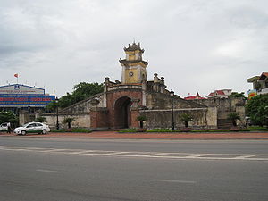
Quang Binh province is the land of rich culture and famous people. There is an archaeological site of Bau Tro
, Phu Luu ancient bronze drums in the time of Dong Son's culture. There are also many historical relics such as Quang Binh Quan, Luy Thay, Rao Sen, Nha Ngo Citadel, parapet and outer walls of Trinh - Nguyen, famous places during the wars such as Cu Nam, Canh Duong, Cha Lo, Xuan Son sky gate, Long Dai, Ho Chi Minh Trail
... In the past time, there were many Quang Binh people of great education, gaining top position in examinations, many cultural and academic villages such as "Bat Danh Huong" (eight famous villages): "Son - Ha - Canh - Tho - Van - Vo - Co - Kim" to be praised from generation to generation. Many celebrities such as Dương Văn An
, Nguyễn Hữu Cảnh
, Nguyen Ham Ninh, Hoàng Kế Viêm,... and famous historical figure, General Vo Nguyen Giap were originated from Quang Binh. There are many festivals and typical traditional villages.
Quảng Bình is also home to many types of hò, foklore singings like Hò khoan Lệ Thủy, Hò Quảng Trạch.
On July 3, 2007, an earthen pot of ancient coins weighing 20 kg was found buried at 500 cm underground in a paddy field and later sold for US$12.5 per kilo. This site is located in Tran Xa village, Ham Ninh commune, Quang Ninh district. The coins were of Tang Dynasty
period.
Compared to other provinces in areas surrounding Ha Noi and Ho Chi Minh City
and Da Nang
, Quang Binh is the poorer province. Therefore, more and more young and educated here find their ways to the big cities and more industrialized provinces.
In each commune (xã, a rural sudivision of district), there is a clinic and there is a hospital in every county, in Đồng Hới city, there are more. The Đồng Hới Hospital, which was donated by Cuba, was built in the 1980s.
and white clay deposits. The province has two industrial parks, one in Đồng Hới city and the other in Hon La bay. Sea food processing, bio-fertilizer and aluminum production are also important to this provincial economy. Over 80% of the population live on agricultural production. In recent years, tourism has been emerged as the significant contribution to Quang Binh largely thanks to Phong Nha-Ke Bang National Park (World Heritage site) and several white fine sand beaches. Trade conducted with Laos through Cha Lo gate by National Road 12. In 2005, this province's export value is just 30 million US$ or 1% of Vietnam's export revenue. In 2006, the province contributed 608 billion VND (US$ 38 million) to the state budget (of the total US$15.68 billion) or 0.024% only
The province agriculture is comprehensively developed with the direction of production of commodities. Crops and cultivation calendar have been gradually arranged in a more appropriate manner. The food production has been continuously increased reaching 200,000 tons in the year 2000. Industrial trees are well developed, especially long term trees. The total area of industrial trees is 14,105ha, of which the area of rubber is 6,400 ha providing 2,000 tons of dried resin. Cattle and husbandry keep growing. The average agriculture growth rate is 5.7% during the period 1996 - 2000.
In the recent years, forestry production of Quang Binh Province has been changed in terms of structure from mainly exploiting to protecting, developing forest for forest resource conservation. The value of forestry and afforestration has increased 87.3%, in particular from 1996 to 2000 the growth rate was 65.3%. The annual afforestration area is around 4,000 ha. Up to date 38,851 ha of forest has been planted.
Fishery sector has continuously developed and become a key economic sector of the province. At present the province has around 3,200 fishing boats with power of over 67,000CV. In the year 2000, the output of sea products is estimated at 17,104 tons, of which about 1,600 tons is from raising. The province has 3 shrimp nursery stations, 8 fish nursery stations supplying 5 - 7 mil. tiger baby shrimps, 40 - 45mil. baby fish and 4 - 5 mil. fingerlings annually. At present the province has 2 factories of processing frozen sea products and 4 factories of processing dried products for exportation. The services of fishing sector such as making and repairing ships, purchasing, processing sea products and providing technical assistance and infrastructure for fishing are continuously developed. Hower, the development of fishery sector in recent years is not so high as the potentials could provide.
As of February 2008, the province licensed 59 investment project with total capital of $500 million.
As of 2009, this province is home to two special economic zones with preferential investment and tax treatments, namely Hon La Economic Zone
by the seaport Hon La
, and Cha Lo Border Gate Economic Zone
in the border with Laos
.

 Quang Binh has several tourist attraction sites that could be turned into tourism development.
Phong Nha-Ke Bang area is noted for its cave and grotto systems as it is composed of 300 caves and grottoes with a total length of about 70 km, of which only 20 have been surveyed by Vietnamese and British scientists; 17 of these are in located in the Phong Nha area and three in the Ke Bang area. Phong Nha holds several world cave records, as it has the longest underground river, as well as the largest caverns and passageways.
Following UNESCO listing of this park, the number of visitors to this province changed significantly.
Tourists mainly visit Phong Nha Cave
, Tien Son Cave and from 2010, Thien Duong Cave
. Despite atttracting attention, Son Doong Cave
has yet available for visitors due to unavailabiltiy of access road and other relating facilities.
to Cà Mau Province
along the coastline of the country) and Ho Chi Minh Highway
(runs from North-Western part of Vietnam to Cà Mau along the mountainous part, nearly coinciding Ho Chi Minh Trail
). The Road 12 connects this province with Khammouan Province of Laos. The Hanoi-Saigon Railway
crosses Quang Binh Province in the hill area with Đồng Hới Railway Station as a main station. Part of the aborted Thakhek - Tan Ap railway would have crossed the province to connect with the North-South Railway at Tan Ap Railway Station
. Đồng Hới Airport
is located in Đồng Hới city, initially due to be opened at the end of 2007 with scheduled flights to and from Ho Chi Minh City's Tan Son Nhat International Airport
and Ha Noi's Noi Bai International Airport
upon completion.
The construction schedule of the airport was late due to lack of capital from the government. It was scheduled to be completed in February 2008, but the deadline was extended again.
According to the latest revised schedule, this airport will be completed and opened in 3rd quarter of 2008. The airport was officially inaugurated on 18 May 2008 with first filght from Hanoi's Noi Bai International Airport
, then from Ho Chi Minh City
on 1 July 2009. As of September 2009, the only airliner operating here is Vietnam Airlines
with the destinations of Hanoi and Ho Chi Minh City. There will be more air links between this airport and other airports in Vietnam soon. The airport has a designed capacity of 300 passengers per peak hour 500,000 passengers per annum.
Hon La Port, a deep-water port is being built with a designed capacity of 10-12 million metric tons of cargo annually, capable to handle vessels up to 10,000 ton and will serve domestic and international cargo vessels
88.5% inhabitants lives in rural areas, 11.5% lives in urban areas. Labour force accounted for 47.08% of the population (380,306) in 2000. 72% labour works in rural sectors (agriculture and syvicuture), 10.9% works in urban area (industrial, service and commercial sectors). There are 10,720 university graduates and postgraduates (4,676 college graduates and 6042 university graduates) in 2000. Of the blue-collar workers, only 35,000 have passed appropriate training courses.
 Archaeological excavation in this area proved that human living in what is now Quang Binh province in Stone Age
period. Many artifacts such as ceramic vases, stone tools, china was unearthed in Quang Binh.
In 1926, a French archaeologist, Madeleine Colani
, discovered and excavated many artifacts in caves and grottoes in west mountainous areas of Quang Binh. She concluded that there existed the Hòa Bình Culture in this region. Through C14 dating test, the artifacts here dated back to 10,509 (plus or minus 950) ago.
From Quy Dat township (Tuyên Hóa
) to southwest about 150 m, the Hum grotto contains many stone tools and animal stones from an ancient human community. Inside Khai grotto near Quy Dat township, similar artifacts were also found. Especially, there are several ceramics of Dong Son Culture
.
Additionally, artifacts of Stone Age period were also unearthed in some grottoes in Quang Binh region. Owners of these artifacts lived in the caves and grottoes and hunted for their food.
Under Hung kings, when Văn Lang nation founded Văn Lang tribal coalition, Quảng Bình belonged to Việt Thường group. Under Lê Trung Hưng, this province was named Tiên Bình. The central and the south Vietnam (from Ngang mount pass to Bình Thuận Province
was long Champa
Kingdom. The wars between Champa kingdom and Đại Việt before then had happened very regularly, most of the wars logded by Champa kingdom who was then stronger than Đại Việt (Viet the great). Quang Binh was a conflicted territory between Champa and Đại Việt in hundreds of years and became Đại Việt's territory in 1306 after the political marriage of the Trần Dynasty princess Huyền Trân
, to Champa king, Jaya Sinhavarman III (Vietnamese: Chế Mân). Princess Huyen Trần was king Trần Nhân Tông's daughter and king Trần Anh Tông's younger sister. Political matches made to acquire land was a traditional practice by Champa kings. Thanks to this marriage, Đại Việt acquired lands (as dowry) of what is now Quảng Trị Province, and Thừa Thiên–Huế Province (then known respectively as Chau O and Chau Ri or Chau Ly), the new land made Quang Binh not the southernmost and land and southern border of Đại Việt anymore. During Trinh-Nguyễn family war in 17th century, Gianh River in Quang Binh Province was made the frontier between Dang Trong (South Vietnam) and Dang Ngoai (North Vietnam). Đồng Hới city was built as a fortress to protect Nguyen's family Dang Trong from Dang Ngoai's attacks.
In 1604 the provincial name was changed to Quảng Bình. Lord Nguyễn Phúc Khoát divided Quảng Bình into 3 counties (dinh): dinh Bố Chính (formerly dinh Ngói), dinh Mười (or dinh Lưu Đồn), and dinh Quảng Bình (or dinh Trạm).
The province was established in 1831, with the part of phủ Quảng Ninh, then added phủ Quảng Trạch. Under French colony (French Indochina
, Quang Binh was situated in Annam of French Indochina and Đồng Hới airbase in Quang Binh was used by French army to attack Viet Minh in north-central Vietnam and Laotian Pathet army in north and south Laos. In 1954, the Geneva Accord
was signed by France and Vietnam and involved parties. According to which, Vietnam is temporarily divided into 2 part with Parallel 17 as frontier. The North Vietnam was under communist control while the South Vietnam was in anti-communist and French collaborators control and a universal election would be held in 1956 to unify the country. However, in the South, Ngo Dinh Diem
held a referendum
determined the form of government of the State of Vietnam, the nation that was to become the Republic of Vietnam and founded pro-American the Republic of Vietnam. Quang Binh belonged to the North Vietnam, just 50 km north of Seventeenth parallel
. During Vietnam War
, Quang Binh was the most severely destroyed province by US B 52
bombardments due to its location near to the Seventeenth parallel and the important part of Ho Chi Minh Trail
.
In 1976, Quảng Bình, Quảng Trị Province
, Thừa Thiên Province
Province were merged into Bình Trị Thiên Province, in 1990 Binh Tri Thien Province was split into three provinces as they were before.
Lê Dynasty
The Later Lê Dynasty , sometimes referred to as the Lê Dynasty was the longest-ruling dynasty of Vietnam, ruling the country from 1428 to 1788, with a brief interruption....
, this province was renamed Quảng Bình in 1604) is a province
Provinces of Vietnam
Vietnam is divided into 58 provinces and five centrally governed cities existing at the same level as provinces ....
in the North Central Coast
Bac Trung Bo
Bắc Trung Bộ is one of the regions of Vietnam. It consists of six provinces: Thanh Hóa, Nghệ An, Hà Tĩnh, Quảng Bình, Quảng Trị, Thừa Thiên-Huế...
of Vietnam
Vietnam
Vietnam – sometimes spelled Viet Nam , officially the Socialist Republic of Vietnam – is the easternmost country on the Indochina Peninsula in Southeast Asia. It is bordered by China to the north, Laos to the northwest, Cambodia to the southwest, and the South China Sea –...
.
The province has an area of 8,065.8 square kilometers and population of 857,818 inhabitants (as of 2008)
The province is bordered by Laotian
Laos
Laos Lao: ສາທາລະນະລັດ ປະຊາທິປະໄຕ ປະຊາຊົນລາວ Sathalanalat Paxathipatai Paxaxon Lao, officially the Lao People's Democratic Republic, is a landlocked country in Southeast Asia, bordered by Burma and China to the northwest, Vietnam to the east, Cambodia to the south and Thailand to the west...
province of Khammouan on the west, South China Sea
South China Sea
The South China Sea is a marginal sea that is part of the Pacific Ocean, encompassing an area from the Singapore and Malacca Straits to the Strait of Taiwan of around...
on the east, Hà Tĩnh Province on the north and Quảng Trị Province
Quang Tri Province
Quảng Trị is a province on the North Central Coast of Vietnam, north of the former imperial capital of Huế.-Geography:Located in North Central Vietnam, Quang Tri Province is surrounded by Quang Binh Province on the north, Thua Thien-Hue Province on the south, Savannakhet Province of Laos on the...
on the south.
For a long time in history, this region belonged to Văn Lang
Van Lang
Văn Lang was, according to tradition, the first nation of the ancient Vietnamese people, founded in 2879 BC and existing until 258 BC. It was ruled by the Hùng Kings of the Hồng Bàng Dynasty. There is, however, little reliable historical information available...
and then kingdom of Champa
Champa
The kingdom of Champa was an Indianized kingdom that controlled what is now southern and central Vietnam from approximately the 7th century through to 1832.The Cham people are remnants...
and then a conflicted territory between Viet the Great and Champa, it was officially annexed into Đại Việt by Lý Thường Kiệt, a general of Lý Dynasty
Lý Dynasty
The Lý Dynasty , sometimes known as the Later Lý Dynasty , was a Vietnamese dynasty that began in 1009 when Lý Thái Tổ overthrew the Prior Lê Dynasty and ended in 1225 when the queen Lý Chiêu Hoàng was forced to abdicate the throne in favor of her husband, Trần Cảnh. They ruled Vietnam for a...
(under the reign of Lý king Lý Thánh Tông
Lý Thánh Tông
Lý Thánh Tông was the posthumous title of the third emperor of the Lý dynasty of Vietnam. Like his father, he was considered as one of the most talented and benevolent kings in Vietnamese history.-Genius Crown Prince:...
). The site of the present Quang Binh was battlefields between Champa and Vietnam until the Vietnamese territory was expanded farther south in the following dynasties. Quang Binh emerged its importance since Nguyễn Hoàng, a prince of Nguyễn Lords was sent by Lê
Lê Dynasty
The Later Lê Dynasty , sometimes referred to as the Lê Dynasty was the longest-ruling dynasty of Vietnam, ruling the country from 1428 to 1788, with a brief interruption....
king to the south. He developed his manor and turned it into a strong state Dang Trong, a rival of de facto
De facto
De facto is a Latin expression that means "concerning fact." In law, it often means "in practice but not necessarily ordained by law" or "in practice or actuality, but not officially established." It is commonly used in contrast to de jure when referring to matters of law, governance, or...
Trịnh-controlled Dang Ngoai. Quang Binh under Nguyễn Lords became an important front to defence Dang Trong from Dang Ngoai's attack. Under the French rule
French Indochina
French Indochina was part of the French colonial empire in southeast Asia. A federation of the three Vietnamese regions, Tonkin , Annam , and Cochinchina , as well as Cambodia, was formed in 1887....
, this province was part of An Nam. During the Vietnam War
Vietnam War
The Vietnam War was a Cold War-era military conflict that occurred in Vietnam, Laos, and Cambodia from 1 November 1955 to the fall of Saigon on 30 April 1975. This war followed the First Indochina War and was fought between North Vietnam, supported by its communist allies, and the government of...
, this province was part of communist-controlled Democratic Republic of Vietnam or North Vietnam, only 20 km from the DMZ. This province was severely devastated by bombing from U.S. B-52s.
This province is home to the World Heritage Phong Nha-Ke Bang National Park. The province is also home to several famous Vietnamese persons, including general Vo Nguyen Giap
Vo Nguyen Giap
Võ Nguyên Giáp is a retired Vietnamese officer in the Vietnam People’s Army and a politician. He was a principal commander in two wars: the First Indochina War and the Vietnam War...
, the family of former South Vietnam
South Vietnam
South Vietnam was a state which governed southern Vietnam until 1975. It received international recognition in 1950 as the "State of Vietnam" and later as the "Republic of Vietnam" . Its capital was Saigon...
ese president Ngo Dinh Diem
Ngo Dinh Diem
Ngô Đình Diệm was the first president of South Vietnam . In the wake of the French withdrawal from Indochina as a result of the 1954 Geneva Accords, Diệm led the effort to create the Republic of Vietnam. Accruing considerable U.S. support due to his staunch anti-Communism, he achieved victory in a...
, poet Han Mac Tu
Han Mac Tu
Hàn Mặc Tử was a Vietnamese poet. He was born Nguyễn Trọng Trí, at Lệ Mỹ Village, Đồng Hới District, Quảng Bình Province. His pen names included: Minh Duệ, Phong Trần, Lệ Thanh, and finally Hàn Mặc Tử, by which name is known today. He grew up in a poor family, his father having died when he was...
, and writer Bao Ninh
Bao Ninh
Bảo Ninh is a Vietnamese novelist and short story writer.His real name is Hoàng Ấu Phương and he was born in Nghệ An province , Vietnam. During the Vietnam War, he served in the Glorious 27th Youth Brigade...
.
Location and area
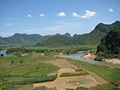
Coordinates 16°55’ to 18°05’ North and 105°37’ to 107°00’ East. It borders Hà Tĩnh Province on the north with the Ngang mountain pass as the natural frontier, borders Quảng Trị Province by the south, borders Laos by the west, and faces the South China Sea on the east. The narrowest part from east (seaside) to west (Laotian border) is just 40 km. The provincial topography is characterized by a general slope, higher in the west and lower in the east, with hilly and mountainous areas accounting for 85% of the total area. The Annamite RangeAnnamite Range
The Annamite Range or the Annamese Mountains is a mountain range of eastern Indochina, which extends approximately through Laos, Vietnam, and a small area in northeast Cambodia. It is known in Vietnamese as Dãy Trường Sơn, in Lao as Xai Phou Luang , and in French as the Chaîne Annamitique...
is the natural border between Quảng Bình Province and Laos
Laos
Laos Lao: ສາທາລະນະລັດ ປະຊາທິປະໄຕ ປະຊາຊົນລາວ Sathalanalat Paxathipatai Paxaxon Lao, officially the Lao People's Democratic Republic, is a landlocked country in Southeast Asia, bordered by Burma and China to the northwest, Vietnam to the east, Cambodia to the south and Thailand to the west...
with peaks ranging from 1,000 to 1,500 m, the summit of which is peak Phi Co Pi with the height of 2,017 m. In the east of the province are lower hills and then several narrow plains and river deltas. The seaside sand dunes belt is a natural dam that protects the land from the ocean tides.
The provincial land area is 8,037.9 km² and divided as follows:
- Inhabited land: 41.45 km²
- Agriculture: 1635.46 km²
- Forest: 4912.62 km²
- Specific usage: 199.36 km²
- Unused: 26.01 km²
Sand area accounts for 5.9% of the land, and alluvial soil accounts for only 2.8% of the land. The province's east coastline is 116.04 km long and the western borderline with Laos is 201.81 km long. The province owns 4866.88 km² of forests, of which 4478.37 km² is natural jungle, and 388.54 km² is reforestation (including 175.97 km² of pines).
The province is located at the coordinates:
- The northernmost point: 180 5'12 N
- The southernmost point: 170 5'02 N
- The westernmost point: 106 59'37 E
- The westernmost point: 105 36'55 E
The coastline is 116.04 km on the east, the borderline with Laos
Laos
Laos Lao: ສາທາລະນະລັດ ປະຊາທິປະໄຕ ປະຊາຊົນລາວ Sathalanalat Paxathipatai Paxaxon Lao, officially the Lao People's Democratic Republic, is a landlocked country in Southeast Asia, bordered by Burma and China to the northwest, Vietnam to the east, Cambodia to the south and Thailand to the west...
is 201.87 km on the west.
Rivers and sea
- Gianh RiverGianh RiverThe Gianh River is a river in the Quang Binh Province of Vietnam's North Central Coast . The river is 268 km in length.It was the border between ruling families during the partition of Vietnam following the Trịnh-Nguyễn War of the 17th century, serving to effectively divide the country between...
(this historic river used to be the border splitting Vietnam into two countries during the Trịnh-Nguyễn War) - Ron RiverRon RiverRon River is a river in Quang Binh Province, north central coast of Vietnam...
- Nhật Lệ River (the confluence of Kiến Giang River and Long Đại River)
- Ly Hoa River
- Dinh River
- Kiến Giang River in Lệ Thủy District
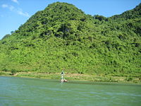
- Son RiverSon River (Vietnam)Son River or Troc River is a tributary of Gianh River in Quang Binh Province, Bac Trung Bo, Vietnam. This river runs in the territory of Quang Binh Province. The upstream of this river with the length of 7729 m runs underground in limestone mountains of Phong Nha-Ke Bang National Park.....
in Phong Nha-Ke Bang
Most of the rivers originate in the Truong Son Range and empty into South China Sea
South China Sea
The South China Sea is a marginal sea that is part of the Pacific Ocean, encompassing an area from the Singapore and Malacca Straits to the Strait of Taiwan of around...
. River and stream density is 1.1 km/km². There are 160 natural and man-made lakes with total water deposit of 234.3 million cubic meter of fresh water.
Quảng Bình Province's sea area includes continental shelf and special economic area up to 20,000 km². Off the sea, there lie Hon La islet, Hòn Gió islet, Hòn Nồm islet, Hòn Cỏ islet, Hòn Chùa islets with the total fishery capacity of 100,000 metric tonnes. Hon La bay is a 4-square-km marine bay with the depth up to 15 m and a surrounding land of 4 km² suitable to develop sea deep-water port and industrial park.
Mounts
Phong Nha-Ke Bang
Phong Nha - Ke Bang is a national park and UNESCO World Heritage Site in the Bố Trạch and Minh Hóa districts of central Quang Binh Province, in north-central Vietnam, about 500 km south of the nation's capital, Hanoi. The park borders the Hin Namno Nature Reserve in the province of Khammouan,...
area with over 1,000 metres height. Noteworthy peaks are the Peak Co Rilata with ta height of 1,128 m and the Peak Co Preu with a height of 1,213 m.
Mounts in karstic
Karst topography
Karst topography is a geologic formation shaped by the dissolution of a layer or layers of soluble bedrock, usually carbonate rock such as limestone or dolomite, but has also been documented for weathering resistant rocks like quartzite given the right conditions.Due to subterranean drainage, there...
area of the park rise at typical height of above 800 m constitute a continuous range along Laotian-Vietnamese borderline, of which notable summits above 1000 m are: Phu Tạo (1174m), Co Unet (1150m), Phu Canh (1095m), Phu Mun (1078m), Phu Tu En (1078m), Phu On Chinh (1068m), Phu Dung (1064m), Phu Tu Ôc (1053m), Phu Long (1015m), Phu Ôc (1015m), Phu Dong (1002m). Inserting into these summits are 800–1000 m high summits of Phu Sinh (965m), Phu Co Tri (949m), Phu On Boi (933m), Phu Tu (956m), Phu Toan (905m), Phu Phong (902m), núi Ma Ma (835m).
Climate
There are four separate seasons here: in spring (from February to April), it is warm with slight rains, humid and the temperature around 18 to 25 degrees Celsius. In the summer (from May to July), it is hot, dry with little downpours, the temperature may reach up to 35 to 36 degrees Celsius. In the fall, it is rainy, cool with temperature around 22 to 28 degrees Celsius. In the winter, it's humid, slight rain with temperature about 12 to 16 degrees Celsius. Annual average precipitation is around 2,000-2,300 mm. Heaviest rainy season is from September to November. From April to August is the dry season. The hottest months are June–August.Flora
Biodiversity
Biodiversity is the degree of variation of life forms within a given ecosystem, biome, or an entire planet. Biodiversity is a measure of the health of ecosystems. Biodiversity is in part a function of climate. In terrestrial habitats, tropical regions are typically rich whereas polar regions...
, especially typical of Annamites
Annamite Range
The Annamite Range or the Annamese Mountains is a mountain range of eastern Indochina, which extends approximately through Laos, Vietnam, and a small area in northeast Cambodia. It is known in Vietnamese as Dãy Trường Sơn, in Lao as Xai Phou Luang , and in French as the Chaîne Annamitique...
eco-region, especially in Phong Nha-Ke Bang
Phong Nha-Ke Bang
Phong Nha - Ke Bang is a national park and UNESCO World Heritage Site in the Bố Trạch and Minh Hóa districts of central Quang Binh Province, in north-central Vietnam, about 500 km south of the nation's capital, Hanoi. The park borders the Hin Namno Nature Reserve in the province of Khammouan,...
area. According to the results of initial surveys, the primary tropical forest in Phong Nha-Ke Bang 140 families, 427 genera, and 751 species of vascular plants, of which 36 species are endangered and listed in the Vietnam's Red Data Book
Vietnam's Red Data Book
Vietnam's Red Data Book is a list of rare and endangered species of fauna and flora native to Vietnam. This is the important legal basis for relating governmental regulations for the protection of biodiversity and wildlife in Vietnam. Criteria for this book are set forth on the basis of those...
.
The most common tree species in this park are Hopea sp.
Hopea
Hopea is a genus of plant in family Dipterocarpaceae. The genus was named after John Hope, 1725-1786, the first Regius Keeper of the Royal Botanic Garden, Edinburgh. It contains about 104 species, distributed from Sri Lanka and southern India to southern China, and southward throughout Malesia to...
, Sumbaviopsis albicans
Sumbaviopsis albicans
Sumbaviopsis albicans is a plant species of the family Euphorbiaceae and the sole member of the genus Sumbaviopsis.-Synonyms:The genus is also known as:*Adisa Steud.*Adisca Blume...
, Garcinia fagraeoides, Burretiodendron hsienmu
Burretiodendron hsienmu
Burretiodendron hsienmu is a species of flowering plant in the Tiliaceae family.It is found in Vietnam and China.It is threatened by habitat loss.-References:* Sun, W. 1998. . Downloaded on 19 July 2007....
, Chukrasia tabularis, Photinia arboreum and Diospyros salletii. Seedlings can only grow in holes and cracks in the limestone where soil has accumulated, so in general regeneration after disturbance is slow.
The forest type in this national park is dominated by evergreen
Evergreen
In botany, an evergreen plant is a plant that has leaves in all seasons. This contrasts with deciduous plants, which completely lose their foliage during the winter or dry season.There are many different kinds of evergreen plants, both trees and shrubs...
tree species with scattered deciduous trees such as Dipterocarpus kerri, Anogeissus acuminata, Pometia pinnata and Lagerstroemia calyculata
Lagerstroemia calyculata
Lagerstroemia calyculata can be translated from the Vietnamese name as the "guava crape myrtle" ; the name is derived from its very characteristic mottled flaky bark. It is a species of flowering plant in the Lythraceae family and found in Southeast Asia and Oceania.It is a medium-sized tree...
.
In Phong Nha-Ke Bang park, the dominant plant families are the Lauraceae
Lauraceae
The Lauraceae or Laurel family comprises a group of flowering plants included in the order Laurales. The family contains about 55 genera and over 3500, perhaps as many as 4000, species world-wide, mostly from warm or tropical regions, especially Southeast Asia and South America...
, Fabaceae
Fabaceae
The Fabaceae or Leguminosae, commonly known as the legume, pea, or bean family, is a large and economically important family of flowering plants. The group is the third largest land plant family, behind only the Orchidaceae and Asteraceae, with 730 genera and over 19,400 species...
, Theaceae
Theaceae
The Theaceae is a family of flowering plants, composed of shrubs and trees. Some botanists include the family Ternstroemiaceae within the Theaceae while others do not...
and Rosaceae
Rosaceae
Rosaceae are a medium-sized family of flowering plants, including about 2830 species in 95 genera. The name is derived from the type genus Rosa. Among the largest genera are Alchemilla , Sorbus , Crataegus , Cotoneaster , and Rubus...
, with some scattered gymnosperm
Gymnosperm
The gymnosperms are a group of seed-bearing plants that includes conifers, cycads, Ginkgo, and Gnetales. The term "gymnosperm" comes from the Greek word gymnospermos , meaning "naked seeds", after the unenclosed condition of their seeds...
s such as Podocarpus imbricatus, Podocarpus neriifolius
Podocarpus neriifolius
Podocarpus neriifolius is a species of conifer in the Podocarpaceae family.It is found in Brunei, Cambodia, China, Fiji, India, Indonesia, Laos, Malaysia, Myanmar, Nepal, Papua New Guinea, the Philippines, Solomon Islands, Thailand, and Vietnam....
, and Nageia fleuryi
Nageia fleuryi
Nageia fleuryi is a species of conifer in the Podocarpaceae family.It is tree 15-25 m tall, with pyramidal crown, found in Cambodia, China, Laos, and Vietnam.-Source:* Conifer Specialist Group 2000. . Downloaded on 10 July 2007....
.
In this national park, there exists a 5000-ha forest of Calocedrus macrolepis on limestione (Calocedrus rupestris) mounts with about 2,500 trees, 600 per hectare. This is the largest forest of this tree in Vietnam. Most of these trees here are 500–600 years old. These trees are listed in group 2A (rare, precious and limited exploitation) of the official letter 3399/VPCP-NN dated 21 June 2002, an amendment to the Decree 48 by the Government of Vietnam.
Biologists have discovered three rare orchid species. Orchids found here include: Paphiopedilum malipoense
Paphiopedilum malipoense
Paphiopedilum malipoense, described in 1984, is a species of orchid commonly known as the Jade Slipper Orchid. This hemicryptophyte plant starts blooming in the spring time and has one flower per inflorescence. The plant grows in intermediate to cool conditions...
, Paphiopedilum dianthum
Paphiopedilum dianthum
Paphiopedilum dianthum is a species of plant in the Orchidaceae family. It is endemic to southeastern Yunnan, southwestern Guizhou and western Guangxi in China.- Source :* China Plant Specialist Group 2004. . Downloaded on 23 August 2007....
, Paphiopedilum concolor
Paphiopedilum concolor
Paphiopedilum concolor is a small terrestrial orchid described in 1984. It has dark green and grey-green mottled leaves, up to 6 inches long by 1½ inches wide...
. In 1996 IUCN classified these orchid species in danger of extinction in the near future.
Endemic species in Phong Nha-Ke Bang National Park is composed of: Burretiodendron hsienmu
Burretiodendron hsienmu
Burretiodendron hsienmu is a species of flowering plant in the Tiliaceae family.It is found in Vietnam and China.It is threatened by habitat loss.-References:* Sun, W. 1998. . Downloaded on 19 July 2007....
, Cryptocarya lenticellata, Deutzianthus tonkinensis, Eberhardtia tonkinensis, Heritiera macrophylla, Hopea sp.
Hopea
Hopea is a genus of plant in family Dipterocarpaceae. The genus was named after John Hope, 1725-1786, the first Regius Keeper of the Royal Botanic Garden, Edinburgh. It contains about 104 species, distributed from Sri Lanka and southern India to southern China, and southward throughout Malesia to...
, Illicium parviflorum
Illicium parviflorum
Illicium parviflorum, commonly known as yellow anise, is an aromatic evergreen tree or shrub common to the southeastern United States, especially around the states of Florida and Georgia. It is in the same genus as the star anise - Illicium verum, which is commonly used and sold as a spice...
, Litsea baviensis, Madhuca pasquieri
Madhuca pasquieri
Madhuca pasquieri is a species of plant in the Sapotaceae family. It is found in China and Vietnam. It is threatened by habitat loss.-Source:* World Conservation Monitoring Centre 1998. . Downloaded on 22 August 2007....
, Michelia foveolata, Peltophorum tonkinensis, Semecarpus annamensis, Sindora tonkinensis
Sindora tonkinensis
Sindora tonkinensis is a species of legume in the Fabaceae family.It is found in Cambodia and Vietnam.It is threatened by habitat loss.-Source:* World Conservation Monitoring Centre 1998. . Downloaded on 10 July 2007....
.
Fauna
Vietnam's Red Data Book
Vietnam's Red Data Book is a list of rare and endangered species of fauna and flora native to Vietnam. This is the important legal basis for relating governmental regulations for the protection of biodiversity and wildlife in Vietnam. Criteria for this book are set forth on the basis of those...
and 23 other species in the World Red Book of Endangered Species
IUCN Red List
The IUCN Red List of Threatened Species , founded in 1963, is the world's most comprehensive inventory of the global conservation status of biological species. The International Union for Conservation of Nature is the world's main authority on the conservation status of species...
.
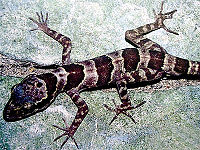
In 2005, a new species of gecko
Gecko
Geckos are lizards belonging to the infraorder Gekkota, found in warm climates throughout the world. They range from 1.6 cm to 60 cm....
(Lygosoma boehmeiwas) was discovered here by a group of Vietnamese biologists together with biologists working for the park, Cologne Zoo
Cologne Zoological Garden
The Aktiengesellschaft Cologne Zoological Garden is the zoo of Cologne, Germany. It features over 7,000 animals of more than 700 species on more than 20 hectares...
in Germany and the Saint Petersburg Wild Zoology Institute in Russia.
The Gaur
Gaur
The gaur , also called Indian bison, is a large bovine native to South Asia and Southeast Asia. The species is listed as vulnerable on the IUCN Red List since 1986 as the population decline in parts of the species' range is likely to be well over 70% over the last three generations...
and one species of eel have been discovered in this park. Ten new species not seen ever in Vietnam were discovered by scientists in this national park.
Phong Nha-Ke Bang is home to significant populations of primate
Primate
A primate is a mammal of the order Primates , which contains prosimians and simians. Primates arose from ancestors that lived in the trees of tropical forests; many primate characteristics represent adaptations to life in this challenging three-dimensional environment...
s in Vietnam, with ten species and sub-speces. These include the globally vulnerable Pig-tailed Macaque
Pig-tailed macaque
The pig-tailed macaques are two macaque sister species. They look almost identical and are best distinguished by their parapatric ranges:* Northern Pig-tailed Macaque, Macaca leonina...
, Assamese Macaque
Assam Macaque
The Assam macaque is a macaque of the Old World monkey family native to South and Southeast Asia. Since 2008, the species is listed as Near Threatened by IUCN, as it is experiencing significant declines due to hunting, habitat degradation and fragmentation.- Characteristics :The Assam macaque has...
, Stump-tailed Macaque
Stump-tailed Macaque
The stump-tailed macaque , also called the bear macaque, is a species of macaque found in Southern Asia. In India, it is found in south of the Brahmaputra river, in northeastern part of the country.Its range in India extends from Assam and Meghalaya to eastern Aruanchal Pradesh, Nagaland, Manipur,...
and White-cheeked Crested Gibbon
White-cheeked Crested Gibbon
The northern white-cheeked gibbon is a species of gibbon native to Vietnam, Laos, and the Yunnan province of China. It is closely related to the southern white-cheeked gibbon , with which it was previously considered conspecific. The females of the two species are virtually indistinguishable in...
(Nomascus leucogenys and Nomascus leucogenys siki). The Park is probably home to the largest population of Francois' Langur
Francois' Langur
Francois' langur or Francois' leaf monkey is a species of lutung and the type species of its species group. Francois' langur belongs to the Colobinae subfamily, Cercopithecidae family, in the Primates order...
in Vietnam, including two different forms of the species. The area is highly significant for its population of Hatinh Langur
Hatinh Langur
The Hatinh langur is a highly threatened Old World monkey found in limestone forests in Vietnam, primarily in the Quang Binh Province. A recent survey discovered a small population living in the Quang Tri Province. Contrary to its name, it is not known from the Ha Tinh Province...
and Black Langur. Ten bat species listed in the IUCN List of Threatened Species have been recorded in this park.
Of the 59 recorded reptile and amphibian species, 18 are listed in Vietnam's Red Data Book
Vietnam's Red Data Book
Vietnam's Red Data Book is a list of rare and endangered species of fauna and flora native to Vietnam. This is the important legal basis for relating governmental regulations for the protection of biodiversity and wildlife in Vietnam. Criteria for this book are set forth on the basis of those...
and 6 are listed in the IUCN Red List of Threatened Animals
IUCN Red List
The IUCN Red List of Threatened Species , founded in 1963, is the world's most comprehensive inventory of the global conservation status of biological species. The International Union for Conservation of Nature is the world's main authority on the conservation status of species...
. The 72 fish species include 4 species endemic to the area, including Chela quangbinhensis
Devario quangbinhensis
Danio quangbinhensis is a species of cyprinid fish found only in Phong Nha-Ke Bang National Park, Quang Binh province, Bac Trung Bo, Vietnam. The adult fish is 8.5 cm....
.
The Phong Nha-Ke Bang park is home to over 200 bird species, inclusive of several rare birds such as: Chestnut-necklaced Partridge
Chestnut-necklaced Partridge
The Chestnut-necklaced Partridge is a species of bird in the Phasianidae family. It is found in forests in the Thai-Malay Peninsula, Sumatra and Borneo. It is closely related to the Vietnam Partridge and Scaly-breasted Partridge, and their taxonomy is not entirely settled.The Chestnut-necklaced...
, Red-collared Woodpecker
Red-collared Woodpecker
The Red-collared Woodpecker is a species of bird in the Picidae family. It is found in Cambodia, China, Laos, and Vietnam.Its natural habitat is temperate forests. It is threatened by habitat loss.-Source:...
, Brown Hornbill
Brown Hornbill
The Austen's Brown Hornbill is a species of hornbill found in forests from north-eastern India and southern China and south to Vietnam and northern Thailand. It is often included as a subspecies of Tickell's Brown Hornbill....
, Sooty Babbler
Sooty Babbler
The Sooty Babbler is a species of bird in the Timaliidae family.It is found in Laos and Vietnam.Its natural habitat is subtropical or tropical moist lowland forests.It is threatened by habitat loss.-References:...
and Short-tailed Scimitar-babbler
Short-tailed Scimitar-babbler
The Short-tailed Scimitar-babbler is a species of bird in the Timaliidae family.It is found in Laos and Vietnam.Its natural habitats are subtropical or tropical moist lowland forests and subtropical or tropical moist montanes....
. There is good evidence for the Vietnamese Pheasant
Vietnamese Pheasant
The Vietnamese Pheasant, or Vietnam Fireback, is a species of gallopheasant. Discovered in 1964, it is endemic to central Vietnam. Its range concentrates around Ke Go Nature Reserve in Ha Tinh Province.-References:*...
(Lophura hatinhensis) and Imperial Pheasant
Imperial Pheasant
The Imperial Pheasant, Lophura × imperialis is a dark blue medium-sized, up to 75 cm long, pheasant with bare red facial skin, blue crest, crimson legs and glossy plumage. Female is brown with erectile short feather crest, blackish tail and primaries.The Imperial Pheasant is found in the...
(Lophura imperialis) species at Phong Nha - Kẻ Bàng area.
An initiative survey conducted by Russian and Vietnamese scientists from Vietnam-Russia Tropical Centre
Vietnam-Russia Tropical Centre
Vietnam-Russia Tropical Centre is a scientific research organization in Vietnam. This centre was established in 1988 by an agreement between the Ministry of National Defense and Russian Academy of Sciences...
(funded by WWF
World Wide Fund for Nature
The World Wide Fund for Nature is an international non-governmental organization working on issues regarding the conservation, research and restoration of the environment, formerly named the World Wildlife Fund, which remains its official name in Canada and the United States...
) recorded 259 butterfly species of 11 families. Almost all major butterfly taxa in Vietnam can be found in Phong Nha - Ke Bang National Park.
Administrative divisions
The province is divided into six huyện (districts) and one city (Đồng Hới)- Bố Trạch
- Lệ Thủy
- Minh Hóa
- Quảng Ninh
- Quảng Trạch
- Tuyên Hóa
The districts are further divided into 154 communes (xã) and these communes are divided into villages (lang or thon).
Like administrative system of Vietnam
Politics of Vietnam
Notwithstanding the 1992 Constitution's affirmation of the central role of the Communist Party, the National Assembly, according to the Constitution, is the highest representative body of the people and the only organization with legislative powers. It has a broad mandate to oversee all government...
, the leader of each administrative unit is the secretary of the local Communist Party Cell. Each administrative unit includes a people's council, who elects a people's committee to execute its daily affairs.
Culture and education
The province is home to Quang Binh UniversityQuang Binh University
Quang Binh University is a university established in 2006 on the basis of merge of some colleges with the Normal College as the core in Dong Hoi city, the capital of Quang Binh Province.The university accept entry exam candidate registers as of 2007...
, a newly-established university from the Normal College of Quảng Bình. This university has faculties of business administration, normal faculty, informatics faculty.
There are several high schools and primary schools in counties. Inhabitants here regards education as family tradition and the most important means to make ends meet and to eliminate poverty.
Quang Binh province is the land of rich culture and famous people. There is an archaeological site of Bau Tro
Bau Tro
Bau Tro is a lake in Dong Hoi city, Quang Binh Province, Vietnam. This lake is an important fresh water supply for more than 130,000 inhabitants of Dong Hoi City. But Bau Tro is more known for archaeological findings by French archaeologists during French Indochina periods...
, Phu Luu ancient bronze drums in the time of Dong Son's culture. There are also many historical relics such as Quang Binh Quan, Luy Thay, Rao Sen, Nha Ngo Citadel, parapet and outer walls of Trinh - Nguyen, famous places during the wars such as Cu Nam, Canh Duong, Cha Lo, Xuan Son sky gate, Long Dai, Ho Chi Minh Trail
Ho Chi Minh trail
The Ho Chi Minh trail was a logistical system that ran from the Democratic Republic of Vietnam to the Republic of Vietnam through the neighboring kingdoms of Laos and Cambodia...
... In the past time, there were many Quang Binh people of great education, gaining top position in examinations, many cultural and academic villages such as "Bat Danh Huong" (eight famous villages): "Son - Ha - Canh - Tho - Van - Vo - Co - Kim" to be praised from generation to generation. Many celebrities such as Dương Văn An
Duong Van An
Dương Văn An was a minister in the cabinet of Mạc Dynasty, in history of Vietnam. He was born in 1514 in Tuy Lộc Village, Lộc Thủy Commune, Lệ Thủy district, Quảng Bình province. He was the author of a famous geography-history book about châu O, Ô Châu cận lục, Hán tự: 烏州近錄...
, Nguyễn Hữu Cảnh
Nguyen Huu Canh
Lễ Thành Hầu Nguyễn Hữu Cảnh or Nguyễn Hữu Kính, Hán tự:阮有鏡, was a general of Lord Nguyễn Phúc Chu. He is considered the one who established territorial sovereignty for Vietnam in Saigon and Gia Dinh regions in 1698...
, Nguyen Ham Ninh, Hoàng Kế Viêm,... and famous historical figure, General Vo Nguyen Giap were originated from Quang Binh. There are many festivals and typical traditional villages.
Quảng Bình is also home to many types of hò, foklore singings like Hò khoan Lệ Thủy, Hò Quảng Trạch.
On July 3, 2007, an earthen pot of ancient coins weighing 20 kg was found buried at 500 cm underground in a paddy field and later sold for US$12.5 per kilo. This site is located in Tran Xa village, Ham Ninh commune, Quang Ninh district. The coins were of Tang Dynasty
Tang Dynasty
The Tang Dynasty was an imperial dynasty of China preceded by the Sui Dynasty and followed by the Five Dynasties and Ten Kingdoms Period. It was founded by the Li family, who seized power during the decline and collapse of the Sui Empire...
period.
Compared to other provinces in areas surrounding Ha Noi and Ho Chi Minh City
Ho Chi Minh City
Ho Chi Minh City , formerly named Saigon is the largest city in Vietnam...
and Da Nang
Da Nang
Đà Nẵng , occasionally Danang, is a major port city in the South Central Coast of Vietnam, on the coast of the South China Sea at the mouth of the Han River. It is the commercial and educational center of Central Vietnam; its well-sheltered, easily accessible port and its location on the path of...
, Quang Binh is the poorer province. Therefore, more and more young and educated here find their ways to the big cities and more industrialized provinces.
In each commune (xã, a rural sudivision of district), there is a clinic and there is a hospital in every county, in Đồng Hới city, there are more. The Đồng Hới Hospital, which was donated by Cuba, was built in the 1980s.
Economy
The provincial GDP per capita is one of the lowest of Vietnam (around US$ 400, compared to Vietnam's average GDP per capita of US$ 700). Industries base on mainly construction material production (ciment, tiles, building rock, brick) thanks to its abundance in limestoneLimestone
Limestone is a sedimentary rock composed largely of the minerals calcite and aragonite, which are different crystal forms of calcium carbonate . Many limestones are composed from skeletal fragments of marine organisms such as coral or foraminifera....
and white clay deposits. The province has two industrial parks, one in Đồng Hới city and the other in Hon La bay. Sea food processing, bio-fertilizer and aluminum production are also important to this provincial economy. Over 80% of the population live on agricultural production. In recent years, tourism has been emerged as the significant contribution to Quang Binh largely thanks to Phong Nha-Ke Bang National Park (World Heritage site) and several white fine sand beaches. Trade conducted with Laos through Cha Lo gate by National Road 12. In 2005, this province's export value is just 30 million US$ or 1% of Vietnam's export revenue. In 2006, the province contributed 608 billion VND (US$ 38 million) to the state budget (of the total US$15.68 billion) or 0.024% only
The province agriculture is comprehensively developed with the direction of production of commodities. Crops and cultivation calendar have been gradually arranged in a more appropriate manner. The food production has been continuously increased reaching 200,000 tons in the year 2000. Industrial trees are well developed, especially long term trees. The total area of industrial trees is 14,105ha, of which the area of rubber is 6,400 ha providing 2,000 tons of dried resin. Cattle and husbandry keep growing. The average agriculture growth rate is 5.7% during the period 1996 - 2000.
In the recent years, forestry production of Quang Binh Province has been changed in terms of structure from mainly exploiting to protecting, developing forest for forest resource conservation. The value of forestry and afforestration has increased 87.3%, in particular from 1996 to 2000 the growth rate was 65.3%. The annual afforestration area is around 4,000 ha. Up to date 38,851 ha of forest has been planted.
Fishery sector has continuously developed and become a key economic sector of the province. At present the province has around 3,200 fishing boats with power of over 67,000CV. In the year 2000, the output of sea products is estimated at 17,104 tons, of which about 1,600 tons is from raising. The province has 3 shrimp nursery stations, 8 fish nursery stations supplying 5 - 7 mil. tiger baby shrimps, 40 - 45mil. baby fish and 4 - 5 mil. fingerlings annually. At present the province has 2 factories of processing frozen sea products and 4 factories of processing dried products for exportation. The services of fishing sector such as making and repairing ships, purchasing, processing sea products and providing technical assistance and infrastructure for fishing are continuously developed. Hower, the development of fishery sector in recent years is not so high as the potentials could provide.
As of February 2008, the province licensed 59 investment project with total capital of $500 million.
As of 2009, this province is home to two special economic zones with preferential investment and tax treatments, namely Hon La Economic Zone
Hon La Economic Zone
Hon La Economic Zone is one of special economic zones in Vietnam. This zone is located by the South China Sea’s Hon La Port in Quảng Trạch District, Quang Binh Province, Bac Trung Bo, Vietnam...
by the seaport Hon La
Hon La Port
Hon La Port is a port located in South China Sea in Quảng Trạch District Quang Binh Province, Vietnam, serving this province, neighboring Laos and especially Hon La Economic Zone. This is one of the main seaports in North Central Coast...
, and Cha Lo Border Gate Economic Zone
Cha Lo Border Gate Economic Zone
Cha Lo Border Gate Economic Zone is a special economic zone in Quang Binh Province, Vietnam. This zone is located at the border gate between Laotian Khammounan Province and Vietnamese Quang Binh Province....
in the border with Laos
Laos
Laos Lao: ສາທາລະນະລັດ ປະຊາທິປະໄຕ ປະຊາຊົນລາວ Sathalanalat Paxathipatai Paxaxon Lao, officially the Lao People's Democratic Republic, is a landlocked country in Southeast Asia, bordered by Burma and China to the northwest, Vietnam to the east, Cambodia to the south and Thailand to the west...
.
Landscapes and attractions
- Phong Nha-Ke Bang National Park: This park features a karstKarst topographyKarst topography is a geologic formation shaped by the dissolution of a layer or layers of soluble bedrock, usually carbonate rock such as limestone or dolomite, but has also been documented for weathering resistant rocks like quartzite given the right conditions.Due to subterranean drainage, there...
region of more than 200,000 km² if Hin NamnoHin NamnoHin Namno or Hin Namno National Biodiversity Conservation Area is a nature reserve in Khammouane Province, Laos. This are borders Phong Nha-Ke Bang of Vietnam to the east....
region in LaosLaosLaos Lao: ສາທາລະນະລັດ ປະຊາທິປະໄຕ ປະຊາຊົນລາວ Sathalanalat Paxathipatai Paxaxon Lao, officially the Lao People's Democratic Republic, is a landlocked country in Southeast Asia, bordered by Burma and China to the northwest, Vietnam to the east, Cambodia to the south and Thailand to the west...
bordering this park is combined. Phong Nha-Ke Bang is a protected area, a national parkNational parkA national park is a reserve of natural, semi-natural, or developed land that a sovereign state declares or owns. Although individual nations designate their own national parks differently A national park is a reserve of natural, semi-natural, or developed land that a sovereign state declares or...
and was listed in UNESCO's world heritageWorld Heritage SiteA UNESCO World Heritage Site is a place that is listed by the UNESCO as of special cultural or physical significance...
in 2003. Phong Nha-Ke bang is located in the Bố TrạchBo TrachBố Trạch is a rural district in Quang Binh province. The district capital is Hoan Lao townlet. Bo Trach borders capital city of Dong Hoi to the south-east and Tuyen Hoa district and Quang Trach district to the north, Quang Ninh to the south and Minh Hoa to the north-west. Bo Trach is home to...
and Minh HóaMinh HoaMinh Hóa is a district in Quang Binh province, in the North Central Coast of Vietnam. This district is composed one townlet and 15 communes : Xuân Hoá, Yên Hoá, Trung Hoá, Tân Hoá, Minh Hoá, Hồng Hoá, Hóa Tiến, Hóa Hợp, Hóa Sơn, Hóa Phúc, Hóa Thanh, Dân Hoá, Thượng Hoá, Trọng Hóa, Quy Hóa.As of...
districts, in north-centralBac Trung BoBắc Trung Bộ is one of the regions of Vietnam. It consists of six provinces: Thanh Hóa, Nghệ An, Hà Tĩnh, Quảng Bình, Quảng Trị, Thừa Thiên-Huế...
Vietnam, about 50 km northwest of Đồng Hới, 42 km east of South China Sea from its borderline point. Phong Nha-Ke Bang National Park is situated in a limestone zone of 200,000 hectare in Vietnamese territory and borders another limestone of 200,000 hectare of Hin Namno in Laotian territory. The core zone of this national park covers 85,754 hectares and a buffer zone of 195,400 ha. The park was created to protect one of the world's two largest karstKarst topographyKarst topography is a geologic formation shaped by the dissolution of a layer or layers of soluble bedrock, usually carbonate rock such as limestone or dolomite, but has also been documented for weathering resistant rocks like quartzite given the right conditions.Due to subterranean drainage, there...
regions with 300 caves and grottoGrottoA grotto is any type of natural or artificial cave that is associated with modern, historic or prehistoric use by humans. When it is not an artificial garden feature, a grotto is often a small cave near water and often flooded or liable to flood at high tide...
es and also protects the ecosystemEcosystemAn ecosystem is a biological environment consisting of all the organisms living in a particular area, as well as all the nonliving , physical components of the environment with which the organisms interact, such as air, soil, water and sunlight....
of limestoneLimestoneLimestone is a sedimentary rock composed largely of the minerals calcite and aragonite, which are different crystal forms of calcium carbonate . Many limestones are composed from skeletal fragments of marine organisms such as coral or foraminifera....
forest of the Annamite RangeAnnamite RangeThe Annamite Range or the Annamese Mountains is a mountain range of eastern Indochina, which extends approximately through Laos, Vietnam, and a small area in northeast Cambodia. It is known in Vietnamese as Dãy Trường Sơn, in Lao as Xai Phou Luang , and in French as the Chaîne Annamitique...
region in north central coastBac Trung BoBắc Trung Bộ is one of the regions of Vietnam. It consists of six provinces: Thanh Hóa, Nghệ An, Hà Tĩnh, Quảng Bình, Quảng Trị, Thừa Thiên-Huế...
of Vietnam.
Phong Nha-Ke Bang area is noted for its cave and grotto systems as it is composed of 300 caves and grottoes with a total length of about 70 km, of which only 20 have been surveyed by Vietnamese and British scientists; 17 of these are in located in the Phong Nha area and three in the Ke Bang area. Phong Nha holds several world cave records, as it has the longest underground river, as well as the largest caverns and passageways.
Following UNESCO listing of this park, the number of visitors to this province changed significantly.
Tourists mainly visit Phong Nha Cave
Phong Nha cave
Phong Nha Cave is a cave in Phong Nha-Ke Bang National Park, a UNESCO World Heritage Site in Quang Binh Province, Vietnam. It is 7729 meters long and contains 14 grottos, as well as a 13,969 meter underground river. While scientists have surveyed it to a depth of 44.5 kilometers, tourists are only...
, Tien Son Cave and from 2010, Thien Duong Cave
Thien Duong Cave
Thiên Đường Cave is a cave in Phong Nha-Ke Bang National Park, UNESCO's World Heritage Site, 60 km northwest of Đồng Hới city....
. Despite atttracting attention, Son Doong Cave
Son Doong Cave
Son Doong cave is a cave in Phong Nha-Ke Bang National Park, Bo Trach District, Quang Binh Province, Vietnam. The cave is located near the Laos-Vietnam border . It has a large fast-flowing underground river inside.The cave was found by a local man named Hồ-Khanh in 1991...
has yet available for visitors due to unavailabiltiy of access road and other relating facilities.
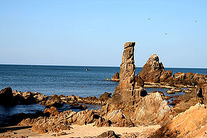
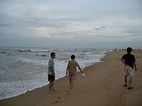
- Da NhayDa Nhay BeachDa Nhay Beach is a beautiful beach on the shore of South China Sea, 40 km north of Dong Hoi city, Quang Binh Province, Vietnam. Da Nhay in Vietnamese means the rocks that jump. This name refers to the topographical feature of this beach which sees thousands rock reaching the sea, surrounding small...
and Ly Hoa Beaches, Nhat Le BeachNhat Le BeachNhật Lệ Beach is a beach in Đồng Hới city, the capital of Quảng Bình Province, home to world heritage Phong Nha-Ke Bang National Park. The sand here is fine and white with clean water. The beach is located on the mouth of the Nhật Lệ River emptying into the South China Sea. There is a four-star...
: these two beaches feature white and fine sands, clean water, and are among one of the most attractive beaches in VietnamVietnamVietnam – sometimes spelled Viet Nam , officially the Socialist Republic of Vietnam – is the easternmost country on the Indochina Peninsula in Southeast Asia. It is bordered by China to the north, Laos to the northwest, Cambodia to the southwest, and the South China Sea –... - Bang SpaBang SpaBang Spa is an area of hot mineral springs in Le Thuy County, Quang Binh Province, Vietnam. The surface mineral water here is hot enough to boil eggs. This is a tourist attraction of the province as many see bathing in hot mineral water as a health treatment for several diseases...
: a hotspring area in Lệ Thủy District with resort and health care services. The temperature of the watwer at the jet hole can reach up to 105 degree Celsius. - Ho Chi Minh TrailHo Chi Minh trailThe Ho Chi Minh trail was a logistical system that ran from the Democratic Republic of Vietnam to the Republic of Vietnam through the neighboring kingdoms of Laos and Cambodia...
battlefield, where there are many important sites along the trail during Vietnam WarVietnam WarThe Vietnam War was a Cold War-era military conflict that occurred in Vietnam, Laos, and Cambodia from 1 November 1955 to the fall of Saigon on 30 April 1975. This war followed the First Indochina War and was fought between North Vietnam, supported by its communist allies, and the government of...
.
Transportation
There are two parallel national roads cross the province: The National Road 1A (runs from Lạng Sơn ProvinceLạng Sơn Province
Lạng Sơn is a province in far northern Vietnam, bordering Guangxi province in China. Its capital is also called Lang Son, which is a strategically important town at the border with China and is northeast of Hanoi connected by rail and road...
to Cà Mau Province
Ca Mau Province
Cà Mau is a province of Vietnam, named after its capital city. It is located in the Mekong Delta of southern Vietnam, and is the southernmost of Vietnam's 58 provinces...
along the coastline of the country) and Ho Chi Minh Highway
Ho Chi Minh Highway
Ho Chi Minh Road or Ho Chi Minh Highway is a highway in Vietnam. It runs from the north to the south of Vietnam, west of National Road 1A. The highway was named after Hồ Chí Minh. The route roughly coincides with the Ho Chi Minh Trail during the Vietnam War...
(runs from North-Western part of Vietnam to Cà Mau along the mountainous part, nearly coinciding Ho Chi Minh Trail
Ho Chi Minh trail
The Ho Chi Minh trail was a logistical system that ran from the Democratic Republic of Vietnam to the Republic of Vietnam through the neighboring kingdoms of Laos and Cambodia...
). The Road 12 connects this province with Khammouan Province of Laos. The Hanoi-Saigon Railway
North-South Railway, Vietnam
The Vietnam North-South Railway, also known as the Reunification Express, is a railway that runs from Ha Noi to Ho Chi Minh City. The total length of this railway is , with a gauge of metre gauge...
crosses Quang Binh Province in the hill area with Đồng Hới Railway Station as a main station. Part of the aborted Thakhek - Tan Ap railway would have crossed the province to connect with the North-South Railway at Tan Ap Railway Station
Tan Ap Railway Station
Tan Ap Railway Station is a railway station on the North-South Railway line in Vietnam. It serves the town of Tân Ấp in Quang Binh Province. From 1933, the station also served as a terminus of the Tan Ap - Xom Cuc railway, the only stretch of railway opened as part of the aborted Thakhek - Tan Ap...
. Đồng Hới Airport
Dong Hoi Airport
Dong Hoi Airport is an airport located in Loc Ninh commune, 6 km north of Dong Hoi city, capital of Quang Binh province, in North Central Coast of Vietnam, 500 km South-east of Hanoi by road. The facilities cover 173 ha, on a sandy area, by the coast of South China Sea...
is located in Đồng Hới city, initially due to be opened at the end of 2007 with scheduled flights to and from Ho Chi Minh City's Tan Son Nhat International Airport
Tan Son Nhat International Airport
Tan Son Nhat International Airport is Vietnam's largest international airport in terms of area . It has a handling capacity of 15-17 million passengers per year, compared with the capacity of Hanoi - Noi Bai airport of 8 million passengers and Da Nang's 2 million passengers...
and Ha Noi's Noi Bai International Airport
Noi Bai International Airport
Noi Bai International Airport in Hanoi, the capital of Vietnam, is the largest in the north of the country. It is 28 miles from the city centre. The travel time from the city centre is 30–45 minutes.-Facilities:...
upon completion.
The construction schedule of the airport was late due to lack of capital from the government. It was scheduled to be completed in February 2008, but the deadline was extended again.
According to the latest revised schedule, this airport will be completed and opened in 3rd quarter of 2008. The airport was officially inaugurated on 18 May 2008 with first filght from Hanoi's Noi Bai International Airport
Noi Bai International Airport
Noi Bai International Airport in Hanoi, the capital of Vietnam, is the largest in the north of the country. It is 28 miles from the city centre. The travel time from the city centre is 30–45 minutes.-Facilities:...
, then from Ho Chi Minh City
Ho Chi Minh City
Ho Chi Minh City , formerly named Saigon is the largest city in Vietnam...
on 1 July 2009. As of September 2009, the only airliner operating here is Vietnam Airlines
Vietnam Airlines
Vietnam Airlines Company Limited, trading as Vietnam Airlines , is the national flag carrier of Vietnam. Founded in 1956 under the name Vietnam Civil Aviation, the airline was established as a state enterprise in April 1989. Vietnam Airlines is headquartered in Long Bien, Hanoi, with hubs at Noi...
with the destinations of Hanoi and Ho Chi Minh City. There will be more air links between this airport and other airports in Vietnam soon. The airport has a designed capacity of 300 passengers per peak hour 500,000 passengers per annum.
Hon La Port, a deep-water port is being built with a designed capacity of 10-12 million metric tons of cargo annually, capable to handle vessels up to 10,000 ton and will serve domestic and international cargo vessels
Demographics
The provincial population is 807,787 (2000). There are 24 ethnic groups live here, predominantly Kinh race, Vân Kiều race and Chứt race. Other minorities are in very small quantity with 100 persons each. All of 23 minority ethnic groups live in mountainous areas. The provincial population is unevenly distributed, with more than 90% live in around 10% of the provincial land while just 10% live in 90% mountainous and sand areas.88.5% inhabitants lives in rural areas, 11.5% lives in urban areas. Labour force accounted for 47.08% of the population (380,306) in 2000. 72% labour works in rural sectors (agriculture and syvicuture), 10.9% works in urban area (industrial, service and commercial sectors). There are 10,720 university graduates and postgraduates (4,676 college graduates and 6042 university graduates) in 2000. Of the blue-collar workers, only 35,000 have passed appropriate training courses.
History
Stone Age
The Stone Age is a broad prehistoric period, lasting about 2.5 million years , during which humans and their predecessor species in the genus Homo, as well as the earlier partly contemporary genera Australopithecus and Paranthropus, widely used exclusively stone as their hard material in the...
period. Many artifacts such as ceramic vases, stone tools, china was unearthed in Quang Binh.
In 1926, a French archaeologist, Madeleine Colani
Madeleine Colani
Madeleine Colani was a female French archaeologist, born in Strasbourg.In 1899, she arrived to Vietnam to teach, in 1914 returned to France to earn her doctorate. From 1920 - 1927, she worked for Indo-chinese geology bureau. She contributed much for Vietnamese archaeology, especially Sa Huỳnh...
, discovered and excavated many artifacts in caves and grottoes in west mountainous areas of Quang Binh. She concluded that there existed the Hòa Bình Culture in this region. Through C14 dating test, the artifacts here dated back to 10,509 (plus or minus 950) ago.
From Quy Dat township (Tuyên Hóa
Tuyen Hoa
Tuyên Hóa is a district of Quang Binh Province in the North Central Coast region of Vietnam. Its seat is the town of Đồng Lê. Speakers of the Nguồn language are mostly located near Đồng Lê. As of 2003 the district had a population of . The district covers an area of 1,149 km²...
) to southwest about 150 m, the Hum grotto contains many stone tools and animal stones from an ancient human community. Inside Khai grotto near Quy Dat township, similar artifacts were also found. Especially, there are several ceramics of Dong Son Culture
Dong Son culture
The Đông Sơn culture was a prehistoric Bronze Age age in Vietnam centered at the Red River Valley of northern Vietnam. At this time the first Vietnamese kingdoms of Văn Lang and Âu Lạc appeared...
.
Additionally, artifacts of Stone Age period were also unearthed in some grottoes in Quang Binh region. Owners of these artifacts lived in the caves and grottoes and hunted for their food.
Under Hung kings, when Văn Lang nation founded Văn Lang tribal coalition, Quảng Bình belonged to Việt Thường group. Under Lê Trung Hưng, this province was named Tiên Bình. The central and the south Vietnam (from Ngang mount pass to Bình Thuận Province
Binh Thuan Province
Bình Thuận is a province of Vietnam. It is located on the country's South Central Coast, not far from Ho Chi Minh City. It is sometimes seen as part of the Southeast Region. Binh Thuan is known for its scenery and for its good beaches...
was long Champa
Champa
The kingdom of Champa was an Indianized kingdom that controlled what is now southern and central Vietnam from approximately the 7th century through to 1832.The Cham people are remnants...
Kingdom. The wars between Champa kingdom and Đại Việt before then had happened very regularly, most of the wars logded by Champa kingdom who was then stronger than Đại Việt (Viet the great). Quang Binh was a conflicted territory between Champa and Đại Việt in hundreds of years and became Đại Việt's territory in 1306 after the political marriage of the Trần Dynasty princess Huyền Trân
Huyen Tran
Princess Huyền Trân , was a princess during the Trần Dynasty in the history of Vietnam. She was the daughter of Emperor Trần Nhân Tông and the younger sister of Emperor Trần Anh Tông...
, to Champa king, Jaya Sinhavarman III (Vietnamese: Chế Mân). Princess Huyen Trần was king Trần Nhân Tông's daughter and king Trần Anh Tông's younger sister. Political matches made to acquire land was a traditional practice by Champa kings. Thanks to this marriage, Đại Việt acquired lands (as dowry) of what is now Quảng Trị Province, and Thừa Thiên–Huế Province (then known respectively as Chau O and Chau Ri or Chau Ly), the new land made Quang Binh not the southernmost and land and southern border of Đại Việt anymore. During Trinh-Nguyễn family war in 17th century, Gianh River in Quang Binh Province was made the frontier between Dang Trong (South Vietnam) and Dang Ngoai (North Vietnam). Đồng Hới city was built as a fortress to protect Nguyen's family Dang Trong from Dang Ngoai's attacks.
In 1604 the provincial name was changed to Quảng Bình. Lord Nguyễn Phúc Khoát divided Quảng Bình into 3 counties (dinh): dinh Bố Chính (formerly dinh Ngói), dinh Mười (or dinh Lưu Đồn), and dinh Quảng Bình (or dinh Trạm).
The province was established in 1831, with the part of phủ Quảng Ninh, then added phủ Quảng Trạch. Under French colony (French Indochina
French Indochina
French Indochina was part of the French colonial empire in southeast Asia. A federation of the three Vietnamese regions, Tonkin , Annam , and Cochinchina , as well as Cambodia, was formed in 1887....
, Quang Binh was situated in Annam of French Indochina and Đồng Hới airbase in Quang Binh was used by French army to attack Viet Minh in north-central Vietnam and Laotian Pathet army in north and south Laos. In 1954, the Geneva Accord
Geneva Accord
The Geneva Initiative, also known as the Geneva Accord, is a model permanent status agreement to end the Israeli-Palestinian conflict based on previous official negotiations, international resolutions, the Quartet Roadmap, the Clinton Parameters, and the Arab Peace Initiative...
was signed by France and Vietnam and involved parties. According to which, Vietnam is temporarily divided into 2 part with Parallel 17 as frontier. The North Vietnam was under communist control while the South Vietnam was in anti-communist and French collaborators control and a universal election would be held in 1956 to unify the country. However, in the South, Ngo Dinh Diem
Ngo Dinh Diem
Ngô Đình Diệm was the first president of South Vietnam . In the wake of the French withdrawal from Indochina as a result of the 1954 Geneva Accords, Diệm led the effort to create the Republic of Vietnam. Accruing considerable U.S. support due to his staunch anti-Communism, he achieved victory in a...
held a referendum
State of Vietnam referendum, 1955
The State of Vietnam referendum of 1955 determined the future form of government of the State of Vietnam, the nation that was to become the Republic of Vietnam . It was contested by Prime Minister Ngô Đình Diệm, who proposed a republic, and former emperor Bảo Đại...
determined the form of government of the State of Vietnam, the nation that was to become the Republic of Vietnam and founded pro-American the Republic of Vietnam. Quang Binh belonged to the North Vietnam, just 50 km north of Seventeenth parallel
17th parallel north
The 17th parallel north is a circle of latitude that is 17 degrees north of the Earth's equatorial plane. It crosses Africa, Asia, the Indian Ocean, the Pacific Ocean, Central America, the Caribbean and the Atlantic Ocean....
. During Vietnam War
Vietnam War
The Vietnam War was a Cold War-era military conflict that occurred in Vietnam, Laos, and Cambodia from 1 November 1955 to the fall of Saigon on 30 April 1975. This war followed the First Indochina War and was fought between North Vietnam, supported by its communist allies, and the government of...
, Quang Binh was the most severely destroyed province by US B 52
B-52 Stratofortress
The Boeing B-52 Stratofortress is a long-range, subsonic, jet-powered strategic bomber operated by the United States Air Force since the 1950s. The B-52 was designed and built by Boeing, who have continued to provide maintainence and upgrades to the aircraft in service...
bombardments due to its location near to the Seventeenth parallel and the important part of Ho Chi Minh Trail
Ho Chi Minh trail
The Ho Chi Minh trail was a logistical system that ran from the Democratic Republic of Vietnam to the Republic of Vietnam through the neighboring kingdoms of Laos and Cambodia...
.
In 1976, Quảng Bình, Quảng Trị Province
Quang Tri Province
Quảng Trị is a province on the North Central Coast of Vietnam, north of the former imperial capital of Huế.-Geography:Located in North Central Vietnam, Quang Tri Province is surrounded by Quang Binh Province on the north, Thua Thien-Hue Province on the south, Savannakhet Province of Laos on the...
, Thừa Thiên Province
Thua Thien-Hue Province
Thừa Thiên-Huế is a province in the North Central Coast of Vietnam, approximately in the center of the country. It borders Quang Tri Provice to the north and Da Nang City to the south, Laos to the west and the South China Sea to the east. The province has 128 km of coastline, 22,000 ha of...
Province were merged into Bình Trị Thiên Province, in 1990 Binh Tri Thien Province was split into three provinces as they were before.
External links
- Official website of the Quang Binh province People's Committee
- Quang Binh News