
New York State Route 173
Encyclopedia
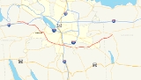
New York State Route 173 (NY 173) is a state highway
located in the Syracuse
area of central New York
, United States
. It takes a slightly bow-shaped route from NY 31
in the town of Van Buren
to NY 5
in Chittenango
, gently curving to the south of Downtown Syracuse
in the center of its 30.59 miles (49.23 km) routing. Even so, NY 173 briefly enters the Syracuse city limits near where it intersects U.S. Route 11 (US 11). NY 173 passes through several suburbs of Syracuse, including Camillus
, where it first meets NY 5, and Manlius
, where it has a short overlap with NY 92
.
NY 173 was assigned as part of the 1930 renumbering of state highways in New York to its modern alignment. The route itself has not been altered since; however, the portion of the route from Onondaga
to Manlius became part of NY 20N
ca. 1938 and a small section of the route within Manlius was included in NY 20SY
when that highway was assigned in the early 1950s. Both designations were removed ca. 1962. All of NY 173 east of Onondaga was originally part of the Seneca Turnpike.
in Ionia, a hamlet within the town of Van Buren
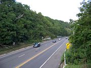
. The route heads southeast, intersecting several county roads as it proceeds through a rural, marshy area of Onondaga County
as Warners Road. It crosses over the New York State Thruway
(Interstate 90 or I-90) on its way into the hamlet of Warners, where it briefly follows Canton Street and crosses the CSX Transportation
-owned Rochester Subdivision
rail line before becoming Warners Road once again as it follows the railroad east out of the community and into the town of Camillus
.
The route parallels the track for roughly 2 miles (3.2 km), over which time it passes to the north of Greenlawn Memorial Park. As the trackage and the highway approach a point known as Amboy Station, NY 173 curves away from the railroad and heads southeast toward Amboy. After making the turn, NY 173 meets Pottery Road (County Route 164 or CR 164), a local road leading to Camillus Airport, a simple one-runway facility located adjacent to the railroad line. NY 173 continues into and through Amboy, passing a large area of tailings
that was once the site of the Syracuse Municipal Airport
. The brownfields are bordered to the north by Ninemile Creek and to the south by the Old Erie Canal
, both of which are traversed by NY 173 on its way into the densely populated Fairmount
neighborhood of Camillus.
 In Fairmount, NY 173 passes Reed Webster Park and turns to the east ahead of the Camillus Bypass, a limited-access highway carrying NY 5
through the town. NY 173 parallels NY 5 for about 1 miles (1.6 km) before connecting to westbound NY 5 by way of a partial interchange; the eastbound connection is made by way of Hinsdale Road (CR 209) 1 miles (1.6 km) to the west. East of the westbound on-ramps, NY 173 passes over NY 5 and turns to the southeast ahead of an intersection with NY 297
. The route continues on through Fairmount, intersecting West Genesee Street (CR 98) before becoming Onondaga Road and exiting the neighborhood upon entering the town of Onondaga
.
Within Onondaga, NY 173 passes through both open areas with sparse development and areas containing built-up residential neighborhoods. The route heads southeast to Onondaga Hill
, a large community built up just east of Onondaga Community College
. Here, it overlaps with NY 175
for about 100 yards (91.4 m) before NY 175 forks off to the northeast into Syracuse. NY 173 continues eastward as the Seneca Turnpike, passing to the south of Community General Hospital before it enters the southernmost portion of Syracuse. This portion of the city is mostly residential, save for a smattering of businesses around NY 173's junctions with NY 80
and US 11. Near the midpoint of the route's 2 miles (3.2 km) stay in Syracuse, it crosses over Onondaga Creek
, on the banks of which lie Faith Heritage School
and Meachem Field. The route leaves the city limits shortly after passing under both directions of I-81
.
All of NY 173 west of Genesee Street in Camillus is maintained by Onondaga County
. NY 173 is co-designated with CR 204 from NY 31 to Bennetts Corners Road in Van Buren
, CR 64 between Bennetts Corners Road and Canton Street in the hamlet of Warners, CR 57 from Canton Street to Thompson Road in Camillus, and CR 63 between Thompson Road and Genesee Street. Within Syracuse, NY 173 is maintained by the city. The remainder of the route in both Onondaga and Madison Counties is maintained by the New York State Department of Transportation
.
as it heads toward the community of Jamesville
, located at the northern end of the Jamesville Reservoir on Butternut Creek. Here, NY 173 intersects NY 91
in the center of the hamlet. Past Jamesville, the homes that had lined the highway give way to open areas to the south and large quarries to the north. The route passes north of the Onondaga County Correctional Facility just east of Jamesville.
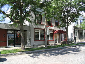 NY 173 continues on into the town of Manlius
, where the homes gradually return as the highway enters the village of Manlius
. Inside the village limits, the route becomes surrounded by homes once again as it crosses over Limestone Creek and enters the village's business district. Here, it intersects and briefly overlaps NY 92
for roughly 250 yards (228.6 m) between Fayette and Washington Streets. At Washington Street, NY 92 turns to the southeast towards Cazenovia
while NY 173 continues northeastward out of the village. Now back in the surrounding town of Manlius, NY 173 passes south of Fayetteville-Manlius High School
before entering another rural area near a point known as Eagle Village. The route continues northeast from there into Madison County
.
Upon crossing the county line, NY 173 initially turns slightly eastward to follow a less pronounced northeasterly alignment. However, as the route approaches the Chittenango Creek
valley, it gradually turns northward. At Brinkerhoff Hill, NY 173 enters the Chittenango
village limits and descends into the valley, where it ends at an intersection with NY 5 in the village center at the base of the valley.
in Onondaga
and NY 5
in Chittenango
was originally part of the original Seneca Turnpike. The Seneca Turnpike was originally the longest road in the state of New York
when it was built in the 1800s. NY 173 was assigned as part of the 1930 renumbering of state highways in New York to the entirety of its modern alignment. Although NY 173 itself has not changed since that time, other routes have been overlaid on parts of NY 173 over the years. Ca. 1938, the segment of NY 173 between NY 175 in Onondaga and the east end of the NY 92
overlap in Manlius
became part of NY 20N
, a northerly alternate route of US 20 between Skaneateles
and Cazenovia
. In the early 1950s, the portion of NY 173 concurrent with NY 92 in Manlius also became part of NY 20SY
, a second, even more northern alternate route of US 20 between Marcellus
and Cazenovia. The NY 20N and NY 20SY designations were removed ca. 1962.
State highway
State highway, state road or state route can refer to one of three related concepts, two of them related to a state or provincial government in a country that is divided into states or provinces :#A...
located in the Syracuse
Syracuse, New York
Syracuse is a city in and the county seat of Onondaga County, New York, United States, the largest U.S. city with the name "Syracuse", and the fifth most populous city in the state. At the 2010 census, the city population was 145,170, and its metropolitan area had a population of 742,603...
area of central New York
Central New York
Central New York is a term used to broadly describe the central region of New York State, roughly including the following counties and cities:...
, United States
United States
The United States of America is a federal constitutional republic comprising fifty states and a federal district...
. It takes a slightly bow-shaped route from NY 31
New York State Route 31
New York State Route 31 is a state highway that extends for across western and central New York in the United States. The western terminus of the route is at an intersection with NY 104 in the city of Niagara Falls. Its eastern terminus is at a traffic circle with NY 26 in Vernon...
in the town of Van Buren
Van Buren, New York
Van Buren is a town located in Onondaga County, New York, United States. As of the 2000 census, the town had a population of 12,667. The town is named after future President Martin van Buren, who was then governor of the state....
to NY 5
New York State Route 5
New York State Route 5 is a state highway that extends for across the state of New York in the United States. It begins at the Pennsylvania state line in the Chautauqua County town of Ripley and passes through Buffalo, Syracuse, Utica, Schenectady, and several other smaller cities and...
in Chittenango
Chittenango, New York
Chittenango is a village located in Madison County, New York, in the United States. The village is in the south part of the Town of Sullivan. The population was 5,081 at the 2010 census.- History :...
, gently curving to the south of Downtown Syracuse
Downtown Syracuse
Downtown Syracuse is the economic center of Syracuse, New York, and Central New York, employing over 30,000 people, and housing over 2,000. It is also one of the 26 officially recognized neighborhoods of Syracuse.- History :...
in the center of its 30.59 miles (49.23 km) routing. Even so, NY 173 briefly enters the Syracuse city limits near where it intersects U.S. Route 11 (US 11). NY 173 passes through several suburbs of Syracuse, including Camillus
Camillus (town), New York
Camillus is a town in Onondaga County, New York, U.S. The population was 24,167 at the 2010 census. The town was named after Roman military leader Marcus Furius Camillus by a clerk interested in the classics....
, where it first meets NY 5, and Manlius
Manlius (village), New York
Manlius is a village in Onondaga County, New York, USA. The population was 4,819 at the 2000 census. The village takes its name from its town.The Village of Manlius is near the south town line of the Town of Manlius and is southeast of the City of Syracuse of which it is a suburb.An area of about...
, where it has a short overlap with NY 92
New York State Route 92
New York State Route 92 is a state highway located in central New York in the United States. The western terminus of the route is at an intersection with U.S. Route 11 in downtown Syracuse. Its eastern terminus is at a junction with US 20 west of the village of Cazenovia...
.
NY 173 was assigned as part of the 1930 renumbering of state highways in New York to its modern alignment. The route itself has not been altered since; however, the portion of the route from Onondaga
Onondaga, New York
Onondaga is a town located in Onondaga County, New York, United States. As of the 2000 U.S. Census, the town had a population of 21,063. The town is named after the native Onondaga tribe, part of the Iroquois Confederacy....
to Manlius became part of NY 20N
New York State Route 20N
New York State Route 20N was a state highway in Central New York, United States. It was an alternate route of U.S. Route 20 that stretched for between Marcellus and Cazenovia. The road began at its parent route, US 20, and NY 174 in Marcellus and ended at US 20,...
ca. 1938 and a small section of the route within Manlius was included in NY 20SY
New York State Route 20N
New York State Route 20N was a state highway in Central New York, United States. It was an alternate route of U.S. Route 20 that stretched for between Marcellus and Cazenovia. The road began at its parent route, US 20, and NY 174 in Marcellus and ended at US 20,...
when that highway was assigned in the early 1950s. Both designations were removed ca. 1962. All of NY 173 east of Onondaga was originally part of the Seneca Turnpike.
West of Syracuse
NY 173 begins at an intersection with NY 31New York State Route 31
New York State Route 31 is a state highway that extends for across western and central New York in the United States. The western terminus of the route is at an intersection with NY 104 in the city of Niagara Falls. Its eastern terminus is at a traffic circle with NY 26 in Vernon...
in Ionia, a hamlet within the town of Van Buren
Van Buren, New York
Van Buren is a town located in Onondaga County, New York, United States. As of the 2000 census, the town had a population of 12,667. The town is named after future President Martin van Buren, who was then governor of the state....
. The route heads southeast, intersecting several county roads as it proceeds through a rural, marshy area of Onondaga County
Onondaga County, New York
Onondaga County is a county located in the U.S. state of New York. As of the 2010 census, the population was 467,026. The county seat is Syracuse.Onondaga County is part of the Syracuse, NY Metropolitan Statistical Area....
as Warners Road. It crosses over the New York State Thruway
New York State Thruway
The New York State Thruway is a system of limited-access highways located within the state of New York in the United States. The system, known officially as the Governor Thomas E. Dewey Thruway for former New York Governor Thomas E. Dewey, is operated by the New York State Thruway Authority and...
(Interstate 90 or I-90) on its way into the hamlet of Warners, where it briefly follows Canton Street and crosses the CSX Transportation
CSX Transportation
CSX Transportation operates a Class I railroad in the United States known as the CSX Railroad. It is the main subsidiary of the CSX Corporation. The company is headquartered in Jacksonville, Florida, and owns approximately 21,000 route miles...
-owned Rochester Subdivision
Rochester Subdivision
The Rochester Subdivision is a railroad line owned by CSX Transportation in the U.S. state of New York. The line runs from Syracuse west to Buffalo along the former New York Central Railroad main line. At its east end, west of downtown Syracuse, the line becomes the Mohawk Subdivision...
rail line before becoming Warners Road once again as it follows the railroad east out of the community and into the town of Camillus
Camillus (town), New York
Camillus is a town in Onondaga County, New York, U.S. The population was 24,167 at the 2010 census. The town was named after Roman military leader Marcus Furius Camillus by a clerk interested in the classics....
.
The route parallels the track for roughly 2 miles (3.2 km), over which time it passes to the north of Greenlawn Memorial Park. As the trackage and the highway approach a point known as Amboy Station, NY 173 curves away from the railroad and heads southeast toward Amboy. After making the turn, NY 173 meets Pottery Road (County Route 164 or CR 164), a local road leading to Camillus Airport, a simple one-runway facility located adjacent to the railroad line. NY 173 continues into and through Amboy, passing a large area of tailings
Tailings
Tailings, also called mine dumps, slimes, tails, leach residue, or slickens, are the materials left over after the process of separating the valuable fraction from the uneconomic fraction of an ore...
that was once the site of the Syracuse Municipal Airport
Syracuse Municipal Airport
Syracuse Municipal Airport was an airport located in Camillus, NY.-Origins:The first plane landed at the site of the airport in 1912 and was flown by Harry Atwood, establishing a long distance flight record from Chicago, Il to Camillus...
. The brownfields are bordered to the north by Ninemile Creek and to the south by the Old Erie Canal
Erie Canal
The Erie Canal is a waterway in New York that runs about from Albany, New York, on the Hudson River to Buffalo, New York, at Lake Erie, completing a navigable water route from the Atlantic Ocean to the Great Lakes. The canal contains 36 locks and encompasses a total elevation differential of...
, both of which are traversed by NY 173 on its way into the densely populated Fairmount
Fairmount, New York
Fairmount is a hamlet in Onondaga County, New York, United States. The Fairmount area was originally part of the New York State Salt Reservation, but was annexed to the Town of Camillus in 1834. Prior to that date, census enumerations for Fairmount were included in the Town of Onondaga census...
neighborhood of Camillus.
New York State Route 5
New York State Route 5 is a state highway that extends for across the state of New York in the United States. It begins at the Pennsylvania state line in the Chautauqua County town of Ripley and passes through Buffalo, Syracuse, Utica, Schenectady, and several other smaller cities and...
through the town. NY 173 parallels NY 5 for about 1 miles (1.6 km) before connecting to westbound NY 5 by way of a partial interchange; the eastbound connection is made by way of Hinsdale Road (CR 209) 1 miles (1.6 km) to the west. East of the westbound on-ramps, NY 173 passes over NY 5 and turns to the southeast ahead of an intersection with NY 297
New York State Route 297
New York State Route 297 is a state highway in the western suburbs of Syracuse, New York, in the United States. It is signed as north–south; however, it follows more of a southwest–northeast alignment for through the towns of Camillus and Geddes. The southern terminus of the route is at an...
. The route continues on through Fairmount, intersecting West Genesee Street (CR 98) before becoming Onondaga Road and exiting the neighborhood upon entering the town of Onondaga
Onondaga, New York
Onondaga is a town located in Onondaga County, New York, United States. As of the 2000 U.S. Census, the town had a population of 21,063. The town is named after the native Onondaga tribe, part of the Iroquois Confederacy....
.
Within Onondaga, NY 173 passes through both open areas with sparse development and areas containing built-up residential neighborhoods. The route heads southeast to Onondaga Hill
Onondaga Hill, New York
Onondaga Hill is a hamlet in the Town of Onondaga in Onondaga County, New York, southwest of the city of Syracuse. It is located on the Seneca Turnpike at the intersection of New York State Route 173 and New York State Route 175....
, a large community built up just east of Onondaga Community College
Onondaga Community College
Onondaga Community College is an accredited two-year educational institution that services Onondaga County, New York at three campuses. Onondaga Community College is a college of the State University of New York system and one of 30 locally sponsored community colleges throughout New York...
. Here, it overlaps with NY 175
New York State Route 175
New York State Route 175 is a west–east state highway located in Onondaga County, New York, in the United States. The route begins at an intersection with U.S. Route 20 east of the village of Skaneateles and passes through the village of Marcellus before ending at a junction with...
for about 100 yards (91.4 m) before NY 175 forks off to the northeast into Syracuse. NY 173 continues eastward as the Seneca Turnpike, passing to the south of Community General Hospital before it enters the southernmost portion of Syracuse. This portion of the city is mostly residential, save for a smattering of businesses around NY 173's junctions with NY 80
New York State Route 80
New York State Route 80 is a west–east New York State Route located within Onondaga, Madison, Chenango, Otsego, Herkimer, and Montgomery Counties in New York. Its western terminus is located at a junction with NY 175 in the city of Syracuse in Onondaga County, from which it...
and US 11. Near the midpoint of the route's 2 miles (3.2 km) stay in Syracuse, it crosses over Onondaga Creek
Onondaga Creek
Onondaga Creek is a major tributary of Onondaga Lake which is located in Onondaga County, New York. The headwaters of the creek originate south of the city of Syracuse near the hamlet of Vesper, New York...
, on the banks of which lie Faith Heritage School
Faith Heritage School
Faith Heritage School is a private, non-denominational Christian, K-12 school in Syracuse, New York that was established in 1972. As of the 2003-2004 school year, its total enrollment was 557, with a student-to-teacher ratio of 14.3, according to NCES figures provided by the United States...
and Meachem Field. The route leaves the city limits shortly after passing under both directions of I-81
Interstate 81 in New York
Interstate 81 is a part of the Interstate Highway System that runs from Dandridge, Tennessee, to the Canada – United States border at Wellesley Island in New York. In the U.S. state of New York, I-81 extends from the Pennsylvania state line southeast of Binghamton to the Canadian border...
.
All of NY 173 west of Genesee Street in Camillus is maintained by Onondaga County
Onondaga County, New York
Onondaga County is a county located in the U.S. state of New York. As of the 2010 census, the population was 467,026. The county seat is Syracuse.Onondaga County is part of the Syracuse, NY Metropolitan Statistical Area....
. NY 173 is co-designated with CR 204 from NY 31 to Bennetts Corners Road in Van Buren
Van Buren, New York
Van Buren is a town located in Onondaga County, New York, United States. As of the 2000 census, the town had a population of 12,667. The town is named after future President Martin van Buren, who was then governor of the state....
, CR 64 between Bennetts Corners Road and Canton Street in the hamlet of Warners, CR 57 from Canton Street to Thompson Road in Camillus, and CR 63 between Thompson Road and Genesee Street. Within Syracuse, NY 173 is maintained by the city. The remainder of the route in both Onondaga and Madison Counties is maintained by the New York State Department of Transportation
New York State Department of Transportation
The New York State Department of Transportation is responsible for the development and operation of highways, railroads, mass transit systems, ports, waterways and aviation facilities in the U.S...
.
East of Syracuse
East of Syracuse, the route passes through a narrow 1 miles (1.6 km) portion of the town of Onondaga and the hamlet of Southwood before entering the adjacent town of DeWitt. It continues east, serving Clark Reservation State ParkClark Reservation State Park
Clark Reservation State Park is a state park in Onondaga County, New York. The park is in the Town of DeWitt, south of Syracuse. It was the site of a large waterfall at the end of the last Ice Age; the plunge basin at the base of the old falls is now a small lake...
as it heads toward the community of Jamesville
Jamesville, New York
Jamesville is a hamlet in De Witt, Onondaga County, New York, United States, part of the greater Syracuse area.The history of the community is documented in the book Water, Wheels and Stone: Heritage of the Little Village by the Creek, Jamesville, New York, written by Jean Schutz Keough, and...
, located at the northern end of the Jamesville Reservoir on Butternut Creek. Here, NY 173 intersects NY 91
New York State Route 91
New York State Route 91 is a north–south state highway in Central New York in the United States. The southern terminus of the route is located at an intersection with NY 13 in the Cortland County town of Truxton. Its northern terminus is located at a junction with NY 173 in...
in the center of the hamlet. Past Jamesville, the homes that had lined the highway give way to open areas to the south and large quarries to the north. The route passes north of the Onondaga County Correctional Facility just east of Jamesville.
Manlius (town), New York
Manlius is a town in Onondaga County, east of the city of Syracuse, New York, United States. The population was 32,370 at the 2010 census, making it the third largest suburb in metropolitan Syracuse...
, where the homes gradually return as the highway enters the village of Manlius
Manlius (village), New York
Manlius is a village in Onondaga County, New York, USA. The population was 4,819 at the 2000 census. The village takes its name from its town.The Village of Manlius is near the south town line of the Town of Manlius and is southeast of the City of Syracuse of which it is a suburb.An area of about...
. Inside the village limits, the route becomes surrounded by homes once again as it crosses over Limestone Creek and enters the village's business district. Here, it intersects and briefly overlaps NY 92
New York State Route 92
New York State Route 92 is a state highway located in central New York in the United States. The western terminus of the route is at an intersection with U.S. Route 11 in downtown Syracuse. Its eastern terminus is at a junction with US 20 west of the village of Cazenovia...
for roughly 250 yards (228.6 m) between Fayette and Washington Streets. At Washington Street, NY 92 turns to the southeast towards Cazenovia
Cazenovia (village), New York
Cazenovia is a village located in the Town of Cazenovia in Madison County, New York, United States. As of the 2000 census, the village had a population of 2,614. The village lies on the southeast shore of Cazenovia Lake, which is approximately long and .5 miles across...
while NY 173 continues northeastward out of the village. Now back in the surrounding town of Manlius, NY 173 passes south of Fayetteville-Manlius High School
Fayetteville-Manlius High School
Fayetteville-Manlius High School is a comprehensive New York public high school on East Seneca Turnpike in the Town of Manlius, serving grades 9-12 in the Fayetteville-Manlius Central School District. It is the only high school in the district, and is the successor to both Wellwood Middle School...
before entering another rural area near a point known as Eagle Village. The route continues northeast from there into Madison County
Madison County, New York
Madison County is a county located in the U.S. state of New York. As of the 2010 census, the population was 73,442. It is named after James Madison, fourth President of the United States of America...
.
Upon crossing the county line, NY 173 initially turns slightly eastward to follow a less pronounced northeasterly alignment. However, as the route approaches the Chittenango Creek
Chittenango Creek
Chittenango Creek is a small river in central New York, USA. Chittenango Creek flows northward through Chittenango into Oneida Lake near the community of Bridgeport and partially forms the boundary between Onondaga County and Madison County...
valley, it gradually turns northward. At Brinkerhoff Hill, NY 173 enters the Chittenango
Chittenango, New York
Chittenango is a village located in Madison County, New York, in the United States. The village is in the south part of the Town of Sullivan. The population was 5,081 at the 2010 census.- History :...
village limits and descends into the valley, where it ends at an intersection with NY 5 in the village center at the base of the valley.
History
The portion of modern NY 173 between NY 175New York State Route 175
New York State Route 175 is a west–east state highway located in Onondaga County, New York, in the United States. The route begins at an intersection with U.S. Route 20 east of the village of Skaneateles and passes through the village of Marcellus before ending at a junction with...
in Onondaga
Onondaga, New York
Onondaga is a town located in Onondaga County, New York, United States. As of the 2000 U.S. Census, the town had a population of 21,063. The town is named after the native Onondaga tribe, part of the Iroquois Confederacy....
and NY 5
New York State Route 5
New York State Route 5 is a state highway that extends for across the state of New York in the United States. It begins at the Pennsylvania state line in the Chautauqua County town of Ripley and passes through Buffalo, Syracuse, Utica, Schenectady, and several other smaller cities and...
in Chittenango
Chittenango, New York
Chittenango is a village located in Madison County, New York, in the United States. The village is in the south part of the Town of Sullivan. The population was 5,081 at the 2010 census.- History :...
was originally part of the original Seneca Turnpike. The Seneca Turnpike was originally the longest road in the state of New York
New York
New York is a state in the Northeastern region of the United States. It is the nation's third most populous state. New York is bordered by New Jersey and Pennsylvania to the south, and by Connecticut, Massachusetts and Vermont to the east...
when it was built in the 1800s. NY 173 was assigned as part of the 1930 renumbering of state highways in New York to the entirety of its modern alignment. Although NY 173 itself has not changed since that time, other routes have been overlaid on parts of NY 173 over the years. Ca. 1938, the segment of NY 173 between NY 175 in Onondaga and the east end of the NY 92
New York State Route 92
New York State Route 92 is a state highway located in central New York in the United States. The western terminus of the route is at an intersection with U.S. Route 11 in downtown Syracuse. Its eastern terminus is at a junction with US 20 west of the village of Cazenovia...
overlap in Manlius
Manlius (village), New York
Manlius is a village in Onondaga County, New York, USA. The population was 4,819 at the 2000 census. The village takes its name from its town.The Village of Manlius is near the south town line of the Town of Manlius and is southeast of the City of Syracuse of which it is a suburb.An area of about...
became part of NY 20N
New York State Route 20N
New York State Route 20N was a state highway in Central New York, United States. It was an alternate route of U.S. Route 20 that stretched for between Marcellus and Cazenovia. The road began at its parent route, US 20, and NY 174 in Marcellus and ended at US 20,...
, a northerly alternate route of US 20 between Skaneateles
Skaneateles (village), New York
Skaneateles is a village in the town of Skaneateles, Onondaga County, New York, United States. The village is named from and located on the shores of Skaneateles Lake, one of the Finger Lakes. The village, as of the 2000 census, has a population of 2,616 residents. The main highway through the...
and Cazenovia
Cazenovia (village), New York
Cazenovia is a village located in the Town of Cazenovia in Madison County, New York, United States. As of the 2000 census, the village had a population of 2,614. The village lies on the southeast shore of Cazenovia Lake, which is approximately long and .5 miles across...
. In the early 1950s, the portion of NY 173 concurrent with NY 92 in Manlius also became part of NY 20SY
New York State Route 20SY
New York State Route 20SY was a state highway in the vicinity of Syracuse, New York, in the United States. It connected U.S. Route 20 to downtown Syracuse via Skaneateles, Camillus, Manlius, and Cazenovia in Onondaga County and Madison County...
, a second, even more northern alternate route of US 20 between Marcellus
Marcellus (town), New York
Marcellus is a town in Onondaga County, New York, United States. The population was 6,319 at the 2000 census. The town was probably named after Marcus Claudius Marcellus, a Roman general, by a clerk interested in the Classics....
and Cazenovia. The NY 20N and NY 20SY designations were removed ca. 1962.