
New York State Route 175
Encyclopedia
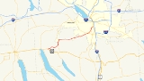
New York State Route 175 (NY 175) is a west–east state highway located in Onondaga County, New York
, in the United States. The 15.46 miles (24.88 km) route begins at an intersection with U.S. Route 20
(US 20) east of the village of Skaneateles
and passes through the village of Marcellus
before ending at a junction with US 11 in Syracuse
. The highway was designated in the 1930 renumbering of state highways in New York.
The section of Route 175 from the town of Marcellus
to the end of the Route 173 concurrency is part of the Seneca Turnpike, which was established in 1800 and dissolved in 1852. This portion of the Seneca Turnpike was instrumental in the development of the villages of Skaneateles and Marcellus. When designated in 1930, Route 175 was on a rural stretch of highway connecting Marcellus to Onondaga
, and brought about an increase in population and development along its route.
in the town of Skaneateles
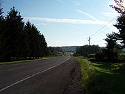
. The highway heads towards the northeast as Lee Mulroy Road, passing by farmlands and fields as well as several residences. As NY 175 heads to the northeast into the town of Marcellus
, it intersects with three county roads. This section of the route is parallel to two other unsigned county roads, located to the northwest and to the southeast.
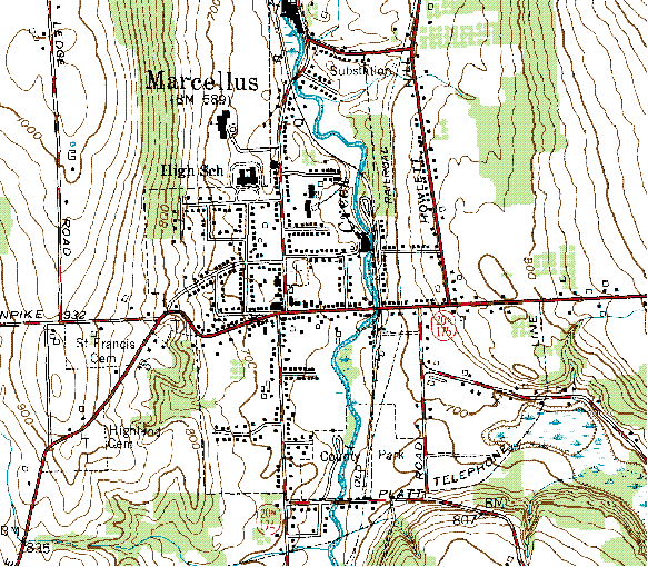
 As the highway heads towards the village of Marcellus
, it begins edging closer to Route 174
. The area becomes slightly more residential as the roads merge and become concurrent. The southern terminus of unsigned County Road 73 (CR 73, named South Street Road) is also at the intersection with NY 174. About 0.6 mile (0.965604 km) southwest of this junction, NY 175 crosses over West Nine Mile Creek on a bridge inventoried by the New York State Department of Transportation
(NYSDOT) as NY 175X. The bridge was built in 1962 and is maintained by Onondaga County
, as is the rest of NY 175 west of NY 174.
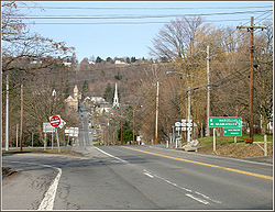 Routes 174 and 175 begin to curve to the northeast as they become parallel with another unsigned county road (CR 150), passing Marcellus County Park along the way. The roads remain as such until an intersection where the county road ends and the two state routes split. In downtown Marcellus, the terrain is flat, with residential homes and commercial businesses surrounding the road. At the split, Route 174 heads to the west through the main street of the village, while Route 175 heads eastward towards Syracuse.
of Wellington Corner, before heading towards Onondaga
. There is a suburban area here, where NY 175 intersects with a county road. The highway then leaves Wellington Corner after the intersection.
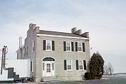
 After exiting Wellington Corner, Route 175 enters another hamlet called Cards Corners. There are a few businesses in this hamlet, with Route 175 and nearby Cedarvale Road being the major roads. The highway then enters a large forested area, at times surrounded by trees. NY 175 continues northeast, passing by several more businesses and soon crosses into the town of Onondaga. In Onondaga, the route passes by the Gen. Orrin Hutchinson House
and the Onondaga Community College
, intersecting with two consecutive county roads along the way before joining with Route 173
. The two roads are concurrent for about 0.2 miles (0.32 km), after which Route 173 heads east towards Manlius
while Route 175 heads northeast towards the city of Syracuse
.
 After leaving Route 173 and the Seneca Turnpike, the highway heads to the northeast through the town of Onondaga as South Avenue. NY 175 passes the Community General Hospital of Greater Syracuse and intersects with a county road before entering the Syracuse
city limits. At this point, maintenance of the route shifts from NYSDOT to the city of Syracuse. In Syracuse, NY 175 runs along the western edge of Saint Agnes Cemetery to an intersection with NY 80
at the cemetery's north end. Much of the next area is both residential and commercial in nature, leaving the fields and forests that the route had previously followed behind.
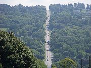
It intersects a number of city streets as it heads to the northeast, traversing several mixed-use blocks before crossing over Onondaga Creek, a north–south waterway that passes through most of Syracuse. On the northeast bank of the creek, NY 175 turns east onto West Kennedy Street, a short connector between the creek and US 11. The route continues for three more blocks along the mostly residential street to US 11, where the east end of West Kennedy Street also marks the east end of NY 175.
and ended in the city of Canandaigua
. Genesee Road was approved by the state legislature in 1794, and construction began in sections from Utica to Canandaigua. In 1800, the road was renamed to "Seneca Turnpike" when a law was passed to establish a maintenance company. At 157 miles (253 km), the turnpike was the longest in the state at the time.
 Soon after settlement of the village of Skaneateles began, the Seneca Turnpike route which originally bypassed the village to the north was relocated southward to go through the growing settlement. The Seneca Turnpike Company closed its doors in 1852. Modern NY 175 does not follow either the original alignment or the relocated alignment, but rather the length of a former trolley line that went from Skaneateles to Syracuse via Marcellus and Onondaga. This trolley line parallels the relocated alignment.
When the NY 175 designation was assigned as part of the 1930 renumbering of state highways in New York, it began at an intersection with US 20 in the village of Skaneateles and utilized the relocated Seneca Turnpike alignment (New Seneca Turnpike) between Skaneateles and Marcellus. This road is now designated as the unsigned
CR 41 by Onondaga County
. Ca. 1938, a 31 miles (50 km) alternate route of US 20 between Skaneateles and Cazenovia
by way of Marcellus was designated as NY 20N
. The new route utilized pre-existing numbered highways, including NY 175 from NY 174 in Marcellus to NY 173 in Onondaga
. The NY 20N designation was removed ca. 1962, as was the nearby NY 20SY
, another alternate route of US 20 that served downtown Syracuse
.
In the 1930s, the western terminus of Route 175 was relocated eastward to Route 174 in downtown Marcellus. The configuration of NY 175 remained unchanged until the early 1960s when the route was re-extended westward over the New Seneca Turnpike to its original terminus in Skaneateles. The section of NY 175 west of Marcellus was realigned in the early 1980s to follow Lee Mulroy Road and NY 174 between US 20 and Marcellus. Ownership and maintenance of the former alignment of NY 175 on the New Seneca Turnpike was eventually transferred to Onondaga County
, which designated the highway as CR 41. Additionally, the modern alignment of NY 175 on Lee Mulroy Road is maintained by Onondaga County and co-designated
as CR 73.
Onondaga County, New York
Onondaga County is a county located in the U.S. state of New York. As of the 2010 census, the population was 467,026. The county seat is Syracuse.Onondaga County is part of the Syracuse, NY Metropolitan Statistical Area....
, in the United States. The 15.46 miles (24.88 km) route begins at an intersection with U.S. Route 20
U.S. Route 20 in New York
U.S. Route 20 is a part of the U.S. Highway System that runs from Newport, Oregon, to Boston, Massachusetts. In the U.S. state of New York, US 20 extends from the Pennsylvania state line at Ripley to the Massachusetts state line in the Berkshire Mountains. US 20 is the longest...
(US 20) east of the village of Skaneateles
Skaneateles (village), New York
Skaneateles is a village in the town of Skaneateles, Onondaga County, New York, United States. The village is named from and located on the shores of Skaneateles Lake, one of the Finger Lakes. The village, as of the 2000 census, has a population of 2,616 residents. The main highway through the...
and passes through the village of Marcellus
Marcellus (village), New York
Marcellus is a village located in the Town of Marcellus in Onondaga County, New York, USA. The population was 1,826 at the 2000 census. The Village of Marcellus is southwest of Syracuse and is in the southern part of the Town of Marcellus.-History:...
before ending at a junction with US 11 in Syracuse
Syracuse, New York
Syracuse is a city in and the county seat of Onondaga County, New York, United States, the largest U.S. city with the name "Syracuse", and the fifth most populous city in the state. At the 2010 census, the city population was 145,170, and its metropolitan area had a population of 742,603...
. The highway was designated in the 1930 renumbering of state highways in New York.
The section of Route 175 from the town of Marcellus
Marcellus (town), New York
Marcellus is a town in Onondaga County, New York, United States. The population was 6,319 at the 2000 census. The town was probably named after Marcus Claudius Marcellus, a Roman general, by a clerk interested in the Classics....
to the end of the Route 173 concurrency is part of the Seneca Turnpike, which was established in 1800 and dissolved in 1852. This portion of the Seneca Turnpike was instrumental in the development of the villages of Skaneateles and Marcellus. When designated in 1930, Route 175 was on a rural stretch of highway connecting Marcellus to Onondaga
Onondaga, New York
Onondaga is a town located in Onondaga County, New York, United States. As of the 2000 U.S. Census, the town had a population of 21,063. The town is named after the native Onondaga tribe, part of the Iroquois Confederacy....
, and brought about an increase in population and development along its route.
Skaneateles to Marcellus
In the west, Route 175 begins at an intersection with US 20U.S. Route 20 in New York
U.S. Route 20 is a part of the U.S. Highway System that runs from Newport, Oregon, to Boston, Massachusetts. In the U.S. state of New York, US 20 extends from the Pennsylvania state line at Ripley to the Massachusetts state line in the Berkshire Mountains. US 20 is the longest...
in the town of Skaneateles
Skaneateles (town), New York
Skaneateles is a town in Onondaga County, New York, United States. The population was 7,323 at the 2000 census. The name is from the Iroquois "Indian" tribe term for the adjacent lake: "long lake." The town is on the western border of the county and includes a village, also called Skaneateles...
. The highway heads towards the northeast as Lee Mulroy Road, passing by farmlands and fields as well as several residences. As NY 175 heads to the northeast into the town of Marcellus
Marcellus (town), New York
Marcellus is a town in Onondaga County, New York, United States. The population was 6,319 at the 2000 census. The town was probably named after Marcus Claudius Marcellus, a Roman general, by a clerk interested in the Classics....
, it intersects with three county roads. This section of the route is parallel to two other unsigned county roads, located to the northwest and to the southeast.
Marcellus (village), New York
Marcellus is a village located in the Town of Marcellus in Onondaga County, New York, USA. The population was 1,826 at the 2000 census. The Village of Marcellus is southwest of Syracuse and is in the southern part of the Town of Marcellus.-History:...
, it begins edging closer to Route 174
New York State Route 174
New York State Route 174 is a state highway in Onondaga County, located in Central New York, United States. The highway is long and passes through mostly rural regions. Route 174 begins at an intersection with NY 41 in Borodino, a hamlet of Spafford...
. The area becomes slightly more residential as the roads merge and become concurrent. The southern terminus of unsigned County Road 73 (CR 73, named South Street Road) is also at the intersection with NY 174. About 0.6 mile (0.965604 km) southwest of this junction, NY 175 crosses over West Nine Mile Creek on a bridge inventoried by the New York State Department of Transportation
New York State Department of Transportation
The New York State Department of Transportation is responsible for the development and operation of highways, railroads, mass transit systems, ports, waterways and aviation facilities in the U.S...
(NYSDOT) as NY 175X. The bridge was built in 1962 and is maintained by Onondaga County
Onondaga County, New York
Onondaga County is a county located in the U.S. state of New York. As of the 2010 census, the population was 467,026. The county seat is Syracuse.Onondaga County is part of the Syracuse, NY Metropolitan Statistical Area....
, as is the rest of NY 175 west of NY 174.
Marcellus to Onondaga
Route 175 heads eastward out of Marcellus along the West Seneca Turnpike. At the intersection with Frank Gay Road (CR 243), Route 175 passes a golf course and country club. The highway continues eastward into the hamletHamlet
The Tragical History of Hamlet, Prince of Denmark, or more simply Hamlet, is a tragedy by William Shakespeare, believed to have been written between 1599 and 1601...
of Wellington Corner, before heading towards Onondaga
Onondaga, New York
Onondaga is a town located in Onondaga County, New York, United States. As of the 2000 U.S. Census, the town had a population of 21,063. The town is named after the native Onondaga tribe, part of the Iroquois Confederacy....
. There is a suburban area here, where NY 175 intersects with a county road. The highway then leaves Wellington Corner after the intersection.
Gen. Orrin Hutchinson House
The Gen. Orrin Hutchinson House, also known as the General George Hutchinson House, is the only Town of Onondaga site listed on the National Register of Historic Places.Orrin Hutchinson was a Brigadier General of the militia. He died in 1842....
and the Onondaga Community College
Onondaga Community College
Onondaga Community College is an accredited two-year educational institution that services Onondaga County, New York at three campuses. Onondaga Community College is a college of the State University of New York system and one of 30 locally sponsored community colleges throughout New York...
, intersecting with two consecutive county roads along the way before joining with Route 173
New York State Route 173
New York State Route 173 is a state highway located in the Syracuse area of central New York, United States. It takes a slightly bow-shaped route from NY 31 in the town of Van Buren to NY 5 in Chittenango, gently curving to the south of Downtown Syracuse in the center of its routing...
. The two roads are concurrent for about 0.2 miles (0.32 km), after which Route 173 heads east towards Manlius
Manlius (village), New York
Manlius is a village in Onondaga County, New York, USA. The population was 4,819 at the 2000 census. The village takes its name from its town.The Village of Manlius is near the south town line of the Town of Manlius and is southeast of the City of Syracuse of which it is a suburb.An area of about...
while Route 175 heads northeast towards the city of Syracuse
Syracuse, New York
Syracuse is a city in and the county seat of Onondaga County, New York, United States, the largest U.S. city with the name "Syracuse", and the fifth most populous city in the state. At the 2010 census, the city population was 145,170, and its metropolitan area had a population of 742,603...
.
Onondaga to Syracuse
Syracuse, New York
Syracuse is a city in and the county seat of Onondaga County, New York, United States, the largest U.S. city with the name "Syracuse", and the fifth most populous city in the state. At the 2010 census, the city population was 145,170, and its metropolitan area had a population of 742,603...
city limits. At this point, maintenance of the route shifts from NYSDOT to the city of Syracuse. In Syracuse, NY 175 runs along the western edge of Saint Agnes Cemetery to an intersection with NY 80
New York State Route 80
New York State Route 80 is a west–east New York State Route located within Onondaga, Madison, Chenango, Otsego, Herkimer, and Montgomery Counties in New York. Its western terminus is located at a junction with NY 175 in the city of Syracuse in Onondaga County, from which it...
at the cemetery's north end. Much of the next area is both residential and commercial in nature, leaving the fields and forests that the route had previously followed behind.
It intersects a number of city streets as it heads to the northeast, traversing several mixed-use blocks before crossing over Onondaga Creek, a north–south waterway that passes through most of Syracuse. On the northeast bank of the creek, NY 175 turns east onto West Kennedy Street, a short connector between the creek and US 11. The route continues for three more blocks along the mostly residential street to US 11, where the east end of West Kennedy Street also marks the east end of NY 175.
History
The section of Route 175 from downtown Marcellus to Route 173 in Onondaga was built along the historical Seneca Turnpike. The turnpike was originally the Genesee Road which began in the city of UticaUtica, New York
Utica is a city in and the county seat of Oneida County, New York, United States. The population was 62,235 at the 2010 census, an increase of 2.6% from the 2000 census....
and ended in the city of Canandaigua
Canandaigua (city), New York
Canandaigua is a city in Ontario County, New York, USA, of which it is the county seat. The population was 11,264 at the 2000 census...
. Genesee Road was approved by the state legislature in 1794, and construction began in sections from Utica to Canandaigua. In 1800, the road was renamed to "Seneca Turnpike" when a law was passed to establish a maintenance company. At 157 miles (253 km), the turnpike was the longest in the state at the time.
When the NY 175 designation was assigned as part of the 1930 renumbering of state highways in New York, it began at an intersection with US 20 in the village of Skaneateles and utilized the relocated Seneca Turnpike alignment (New Seneca Turnpike) between Skaneateles and Marcellus. This road is now designated as the unsigned
Unsigned highway
An unsigned highway is a highway that has been assigned a route number, but does not bear conventional road markings that would normally be used to identify the route with that number...
CR 41 by Onondaga County
Onondaga County, New York
Onondaga County is a county located in the U.S. state of New York. As of the 2010 census, the population was 467,026. The county seat is Syracuse.Onondaga County is part of the Syracuse, NY Metropolitan Statistical Area....
. Ca. 1938, a 31 miles (50 km) alternate route of US 20 between Skaneateles and Cazenovia
Cazenovia (village), New York
Cazenovia is a village located in the Town of Cazenovia in Madison County, New York, United States. As of the 2000 census, the village had a population of 2,614. The village lies on the southeast shore of Cazenovia Lake, which is approximately long and .5 miles across...
by way of Marcellus was designated as NY 20N
New York State Route 20N
New York State Route 20N was a state highway in Central New York, United States. It was an alternate route of U.S. Route 20 that stretched for between Marcellus and Cazenovia. The road began at its parent route, US 20, and NY 174 in Marcellus and ended at US 20,...
. The new route utilized pre-existing numbered highways, including NY 175 from NY 174 in Marcellus to NY 173 in Onondaga
Onondaga, New York
Onondaga is a town located in Onondaga County, New York, United States. As of the 2000 U.S. Census, the town had a population of 21,063. The town is named after the native Onondaga tribe, part of the Iroquois Confederacy....
. The NY 20N designation was removed ca. 1962, as was the nearby NY 20SY
New York State Route 20SY
New York State Route 20SY was a state highway in the vicinity of Syracuse, New York, in the United States. It connected U.S. Route 20 to downtown Syracuse via Skaneateles, Camillus, Manlius, and Cazenovia in Onondaga County and Madison County...
, another alternate route of US 20 that served downtown Syracuse
Downtown Syracuse
Downtown Syracuse is the economic center of Syracuse, New York, and Central New York, employing over 30,000 people, and housing over 2,000. It is also one of the 26 officially recognized neighborhoods of Syracuse.- History :...
.
In the 1930s, the western terminus of Route 175 was relocated eastward to Route 174 in downtown Marcellus. The configuration of NY 175 remained unchanged until the early 1960s when the route was re-extended westward over the New Seneca Turnpike to its original terminus in Skaneateles. The section of NY 175 west of Marcellus was realigned in the early 1980s to follow Lee Mulroy Road and NY 174 between US 20 and Marcellus. Ownership and maintenance of the former alignment of NY 175 on the New Seneca Turnpike was eventually transferred to Onondaga County
Onondaga County, New York
Onondaga County is a county located in the U.S. state of New York. As of the 2010 census, the population was 467,026. The county seat is Syracuse.Onondaga County is part of the Syracuse, NY Metropolitan Statistical Area....
, which designated the highway as CR 41. Additionally, the modern alignment of NY 175 on Lee Mulroy Road is maintained by Onondaga County and co-designated
Concurrency (road)
A concurrency, overlap, or coincidence in a road network is an instance of one physical road bearing two or more different highway, motorway, or other route numbers...
as CR 73.