

Most prominent mountain peaks of Alaska
Encyclopedia
Ultra prominent peak
An ultra prominent peak, or Ultra for short, is a mountain with a topographic prominence of or more. There are a total of roughly 1,524 such peaks in the world. Some are famous even to non-climbers, such as Mount Everest, Aconcagua, and Mount McKinley , while others are much more obscure...
of the U.S. State of Alaska.
Topographic elevation is the vertical distance above the reference geoid
Geoid
The geoid is that equipotential surface which would coincide exactly with the mean ocean surface of the Earth, if the oceans were in equilibrium, at rest , and extended through the continents . According to C.F...
, a precise mathematical model of the Earth's
Earth
Earth is the third planet from the Sun, and the densest and fifth-largest of the eight planets in the Solar System. It is also the largest of the Solar System's four terrestrial planets...
sea level
Sea level
Mean sea level is a measure of the average height of the ocean's surface ; used as a standard in reckoning land elevation...
as an equipotential
Equipotential
Equipotential or isopotential in mathematics and physics refers to a region in space where every point in it is at the same potential. This usually refers to a scalar potential , although it can also be applied to vector potentials...
gravitational surface
Surface
In mathematics, specifically in topology, a surface is a two-dimensional topological manifold. The most familiar examples are those that arise as the boundaries of solid objects in ordinary three-dimensional Euclidean space R3 — for example, the surface of a ball...
. Topographic prominence
Topographic prominence
In topography, prominence, also known as autonomous height, relative height, shoulder drop , or prime factor , categorizes the height of the mountain's or hill's summit by the elevation between it and the lowest contour line encircling it and no higher summit...
is the elevation difference between the summit
Summit (topography)
In topography, a summit is a point on a surface that is higher in elevation than all points immediately adjacent to it. Mathematically, a summit is a local maximum in elevation...
and the highest or key col to a higher summit. Topographic isolation
Topographic isolation
The topographic isolation of a summit is the minimum horizontal distance to the nearest point of higher elevation. Topographic isolation represents a radius of dominance in which the summit is the highest point. Topographic isolation can be calculated for small hills and islands as well as for...
is the minimum great circle
Great circle
A great circle, also known as a Riemannian circle, of a sphere is the intersection of the sphere and a plane which passes through the center point of the sphere, as opposed to a general circle of a sphere where the plane is not required to pass through the center...
distance to a point of higher elevation.
This article defines a significant summit as a summit with at least 100 meters (328.1 feet) of topographic prominence, and a major summit as a summit with at least 500 meters (1640.4 feet) of topographic prominence. An ultra-prominent summit is a summit with at least 1500 meters (4921.3 feet) of topographic prominence.
Six of these peaks lie on the international border with Canada
Canada
Canada is a North American country consisting of ten provinces and three territories. Located in the northern part of the continent, it extends from the Atlantic Ocean in the east to the Pacific Ocean in the west, and northward into the Arctic Ocean...
: four with Yukon
Yukon
Yukon is the westernmost and smallest of Canada's three federal territories. It was named after the Yukon River. The word Yukon means "Great River" in Gwich’in....
and two with the Province of British Columbia.
Most prominent summits
| Rank Ranking A ranking is a relationship between a set of items such that, for any two items, the first is either 'ranked higher than', 'ranked lower than' or 'ranked equal to' the second.... |
Mountain Peak Summit (topography) In topography, a summit is a point on a surface that is higher in elevation than all points immediately adjacent to it. Mathematically, a summit is a local maximum in elevation... |
Mountain Range Mountain range A mountain range is a single, large mass consisting of a succession of mountains or narrowly spaced mountain ridges, with or without peaks, closely related in position, direction, formation, and age; a component part of a mountain system or of a mountain chain... |
Elevation | Prominence Topographic prominence In topography, prominence, also known as autonomous height, relative height, shoulder drop , or prime factor , categorizes the height of the mountain's or hill's summit by the elevation between it and the lowest contour line encircling it and no higher summit... |
Isolation Topographic isolation The topographic isolation of a summit is the minimum horizontal distance to the nearest point of higher elevation. Topographic isolation represents a radius of dominance in which the summit is the highest point. Topographic isolation can be calculated for small hills and islands as well as for... |
|---|---|---|
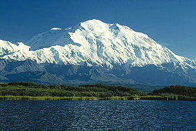
| 1 | Mount McKinley Mount McKinley Mount McKinley or Denali in Alaska, United States is the highest mountain peak in North America and the United States, with a summit elevation of above sea level. It is the centerpiece of Denali National Park and Preserve.- Geology and features :Mount McKinley is a granitic pluton... (Denali) |
Alaska Range Alaska Range The Alaska Range is a relatively narrow, 650-km-long mountain range in the southcentral region of the U.S. state of Alaska, from Lake Clark at its southwest end to the White River in Canada's Yukon Territory in the southeast... |
| 2 | Mount Fairweather Mount Fairweather Mount Fairweather , is one of the world's highest coastal mountains at 4,671 metres It is located east of the Pacific Ocean on the border of Alaska, United States and western British Columbia, Canada... (Fairweather Mountain) |
Saint Elias Mountains Saint Elias Mountains The Saint Elias Mountains are a subgroup of the Pacific Coast Ranges, located in southeastern Alaska in the United States, southwestern Yukon and the very far northwestern part of British Columbia in Canada. The range spans Wrangell-St. Elias National Park and Preserve in the USA and Kluane... |
| 3 | Mount Blackburn Mount Blackburn Mount Blackburn is the highest peak in the Wrangell Mountains of Alaska in the United States. It is the fifth highest peak in the United States and the twelfth highest peak in North America. The mountain is an old, eroded shield volcano, the second highest volcano in the United States behind Mount... |
Wrangell Mountains Wrangell Mountains The Wrangell Mountains are a high mountain range of eastern Alaska in the United States. Much of the range is included in Wrangell-Saint Elias National Park and Preserve. The Wrangell Mountains are almost entirely volcanic in origin, and they include the second and third highest volcanoes in the... |
| 4 | Mount Hayes Mount Hayes Mount Hayes is the highest mountain in the eastern Alaska Range. Despite not being a fourteener, it is one of the largest peaks in the United States in terms of rise above local terrain. For example, the Northeast Face rises 8,000 feet in approximately 2 miles... |
Alaska Range Alaska Range The Alaska Range is a relatively narrow, 650-km-long mountain range in the southcentral region of the U.S. state of Alaska, from Lake Clark at its southwest end to the White River in Canada's Yukon Territory in the southeast... |
| 5 | Mount Saint Elias Mount Saint Elias Mount Saint Elias, also designated Boundary Peak 186, is the second highest mountain in both Canada and the United States, being situated on the Yukon and Alaska border. It lies about southwest of Mount Logan, the highest mountain in Canada. The Canadian side is part of Kluane National Park,... |
Saint Elias Mountains Saint Elias Mountains The Saint Elias Mountains are a subgroup of the Pacific Coast Ranges, located in southeastern Alaska in the United States, southwestern Yukon and the very far northwestern part of British Columbia in Canada. The range spans Wrangell-St. Elias National Park and Preserve in the USA and Kluane... |
| 6 | Mount Marcus Baker Mount Marcus Baker Mount Marcus Baker is the highest peak of the Chugach Mountains of Alaska.It is located approximately 75 miles east of Anchorage. This peak is very prominent because of its proximity to tidewater and is only 12 miles north of the calving face of Harvard Glacier.When ranked by topographic... |
Chugach Mountains Chugach Mountains The Chugach Mountains of southern Alaska are the northernmost of the several mountain ranges that make up the Pacific Coast Ranges of the western edge of North America. The range is about 500 km long, running generally east-west. Its highest point is Mount Marcus Baker, at , but most of its... |
| 7 | Shishaldin Volcano | Unimak Island Unimak Island Unimak Island is the largest island in the Aleutian Islands chain of the U.S. state of Alaska. It is the easternmost island in the Aleutians and, with an area of 1,571.41 mi² , the ninth largest island in the United States and the 134th largest island in the world. It is home to Mount... |
| 8 | Mount Redoubt Mount Redoubt (Alaska) Mount Redoubt, or Redoubt Volcano, is an active stratovolcano in the largely volcanic Aleutian Range of the U.S. state of Alaska. Located in the Chigmit Mountains , the mountain is just west of Cook Inlet, in the Kenai Peninsula Borough about 180 km southwest of Anchorage... |
Chigmit Mountains Chigmit Mountains The Chigmit Mountains are a subrange of the Aleutian Range in the Kenai Peninsula and Lake and Peninsula Boroughs of the U.S. state of Alaska.-Location:... |
| 9 | Mount Torbert Mount Torbert Mount Torbert is the highest point of the Tordrillo Mountains, a small, primarily volcanic range, northwest of Anchorage, Alaska. It is a heavily glaciated peak, and is not itself a volcano, although nearby Mount Spurr and Crater Peak are active volcanoes.... |
Alaska Range Alaska Range The Alaska Range is a relatively narrow, 650-km-long mountain range in the southcentral region of the U.S. state of Alaska, from Lake Clark at its southwest end to the White River in Canada's Yukon Territory in the southeast... |
| 10 | Mount Pavlof Mount Pavlof Pavlof Volcano is a stratovolcano of the Aleutian Range on the Alaska Peninsula. It has been one of the most active in the United States since 1980, with eruptions recorded in 1980, 1981, 1983, 1986–1988, 1996–1997, and an ongoing eruption starting on August 15, 2007 and ending on September 13... |
Alaska Peninsula Alaska Peninsula The Alaska Peninsula is a peninsula extending about to the southwest from the mainland of Alaska and ending in the Aleutian Islands. The peninsula separates the Pacific Ocean from Bristol Bay, an arm of the Bering Sea.... |
| 11 | Mount Veniaminof Mount Veniaminof Mount Veniaminof is an active stratovolcano located on the Alaska Peninsula. The Alaska Volcano Observatory currently rates Veniaminof as Aviation Color Code GREEN and Volcano Alert Level NORMAL as of 15:36, 3 June 2009... |
Alaska Peninsula Alaska Peninsula The Alaska Peninsula is a peninsula extending about to the southwest from the mainland of Alaska and ending in the Aleutian Islands. The peninsula separates the Pacific Ocean from Bristol Bay, an arm of the Bering Sea.... |
| 12 | Mount Hubbard Mount Hubbard Mount Hubbard is one of the major mountains of the Saint Elias Range. It is located on the Alaska/Yukon border; the Canadian side is within Kluane National Park and Reserve, and the American side is part of Wrangell-St. Elias National Park... |
Saint Elias Mountains Saint Elias Mountains The Saint Elias Mountains are a subgroup of the Pacific Coast Ranges, located in southeastern Alaska in the United States, southwestern Yukon and the very far northwestern part of British Columbia in Canada. The range spans Wrangell-St. Elias National Park and Preserve in the USA and Kluane... |
| 13 | Iliamna Volcano | Chigmit Mountains Chigmit Mountains The Chigmit Mountains are a subrange of the Aleutian Range in the Kenai Peninsula and Lake and Peninsula Boroughs of the U.S. state of Alaska.-Location:... |
| 14 | Mount Sanford | Wrangell Mountains Wrangell Mountains The Wrangell Mountains are a high mountain range of eastern Alaska in the United States. Much of the range is included in Wrangell-Saint Elias National Park and Preserve. The Wrangell Mountains are almost entirely volcanic in origin, and they include the second and third highest volcanoes in the... |
| 15 | Mount Tom White | Chugach Mountains Chugach Mountains The Chugach Mountains of southern Alaska are the northernmost of the several mountain ranges that make up the Pacific Coast Ranges of the western edge of North America. The range is about 500 km long, running generally east-west. Its highest point is Mount Marcus Baker, at , but most of its... |
| 16 | Mount Cook Mount Cook (Saint Elias Mountains) Mount Cook is a high peak on the Yukon Territory-Alaska border, in the Saint Elias Mountains of North America. It is approximately 15 miles southwest of Mount Vancouver and 35 miles east-southeast of Mount Saint Elias. It forms one of the corners of the jagged border, which is defined to run in... |
Saint Elias Mountains Saint Elias Mountains The Saint Elias Mountains are a subgroup of the Pacific Coast Ranges, located in southeastern Alaska in the United States, southwestern Yukon and the very far northwestern part of British Columbia in Canada. The range spans Wrangell-St. Elias National Park and Preserve in the USA and Kluane... |
| 17 | Mount Kimball Mount Kimball (Alaska) Mount Kimball is the highest mountain in the section of the eastern Alaska Range between Isabel Pass and Mentasta Pass , about 30 miles from Paxson... |
Alaska Range Alaska Range The Alaska Range is a relatively narrow, 650-km-long mountain range in the southcentral region of the U.S. state of Alaska, from Lake Clark at its southwest end to the White River in Canada's Yukon Territory in the southeast... |
| 18 | Mount Chamberlin Mount Chamberlin (Alaska) Mount Chamberlin is the highest peak in the Brooks Range of northern Alaska in the United States. It is the highest peak for over 500 miles ; however, due to its remote location, it sees little climbing activity.... |
Brooks Range Brooks Range The Brooks Range is a mountain range in far northern North America. It stretches from west to east across northern Alaska and into Canada's Yukon Territory, a total distance of about 1100 km . The mountains top out at over 2,700 m . The range is believed to be approximately 126 million years old... |
| 19 | Mount Griggs Mount Griggs Mount Griggs, formerly known as Knife Peak Volcano, is a stratovolcano, which lies 10 km behind the volcanic arc defined by other Katmai group volcanoes. Although no historic eruptions have been reported from Mount Griggs, vigorously active fumaroles persist in a summit crater and along the... |
Alaska Peninsula Alaska Peninsula The Alaska Peninsula is a peninsula extending about to the southwest from the mainland of Alaska and ending in the Aleutian Islands. The peninsula separates the Pacific Ocean from Bristol Bay, an arm of the Bering Sea.... |
| 20 | Mount Foraker Mount Foraker Mount Foraker is a mountain in the central Alaska Range, in Denali National Park, southwest of Mount McKinley. It is the second highest peak in the Alaska Range, and the fourth highest peak in the United States... |
Alaska Range Alaska Range The Alaska Range is a relatively narrow, 650-km-long mountain range in the southcentral region of the U.S. state of Alaska, from Lake Clark at its southwest end to the White River in Canada's Yukon Territory in the southeast... |
| 21 | Mount Crillon Mount Crillon Mount Crillon is a high peak of the Fairweather Range, the southernmost part of the Saint Elias Range. It lies southeast of Mount Fairweather, in the promontory between the Gulf of Alaska and Glacier Bay. It is included in Glacier Bay National Park... |
Saint Elias Mountains Saint Elias Mountains The Saint Elias Mountains are a subgroup of the Pacific Coast Ranges, located in southeastern Alaska in the United States, southwestern Yukon and the very far northwestern part of British Columbia in Canada. The range spans Wrangell-St. Elias National Park and Preserve in the USA and Kluane... |
| 22 | Mount Hesperus | Alaska Range Alaska Range The Alaska Range is a relatively narrow, 650-km-long mountain range in the southcentral region of the U.S. state of Alaska, from Lake Clark at its southwest end to the White River in Canada's Yukon Territory in the southeast... |
| 23 | Mount Vsevidof Mount Vsevidof Mount Vsevidof is a stratovolcano in the U.S. state of Alaska. Its summit is the highest point on Umnak Island, one of the eastern Aleutian Islands. Its symmetrical cone rises abruptly from its surroundings. Its most recent eruption was caused by an earthquake on March 9, 1957... |
Umnak Island |
| 24 | Mount Bona Mount Bona Mount Bona is one of the major mountains of the Saint Elias Mountains in eastern Alaska, and is the fifth highest independent peak in the United States. Mount Bona and its adjacent neighbor Mount Churchill are both large ice-covered stratovolcanoes... |
Saint Elias Mountains Saint Elias Mountains The Saint Elias Mountains are a subgroup of the Pacific Coast Ranges, located in southeastern Alaska in the United States, southwestern Yukon and the very far northwestern part of British Columbia in Canada. The range spans Wrangell-St. Elias National Park and Preserve in the USA and Kluane... |
| 25 | Mount Drum Mount Drum Mount Drum is a stratovolcano in the Wrangell Mountains of east-central Alaska in the United States. It is located at the extreme western end of the Wrangells, west-southwest of Mount Sanford and the same distance west-northwest of Mount Wrangell... |
Wrangell Mountains Wrangell Mountains The Wrangell Mountains are a high mountain range of eastern Alaska in the United States. Much of the range is included in Wrangell-Saint Elias National Park and Preserve. The Wrangell Mountains are almost entirely volcanic in origin, and they include the second and third highest volcanoes in the... |
| 26 | Makushin Volcano Makushin Volcano The Makushin Volcano is an ice-covered stratovolcano located on Unalaska Island in the Aleutian Islands of the U.S. state of Alaska. With an elevation of , it's summit is the highest point on the island. Makushin is one of the most active among the 40 volcanoes of Alaska... |
Unalaska Island Unalaska Island Unalaska is an island in the Fox Islands group of the Aleutian Islands in the U.S. state of Alaska, at . The island has a land area of . The city of Unalaska, Alaska, covers part of the island and all of neighboring Amaknak Island where the Port of Dutch Harbor is located... |
| 27 | Mount Chiginagak Mount Chiginagak Chiginagak Volcano is a stratovolcano in the Aleutian Islands, located about 15 km NW of Chiginagak Bay.- Eruptive history :An unglaciated lava flow and an overlying pyroclastic-flow deposit extending east from the summit are the most recent products of Chiginagak. They most likely originated... |
Alaska Peninsula Alaska Peninsula The Alaska Peninsula is a peninsula extending about to the southwest from the mainland of Alaska and ending in the Aleutian Islands. The peninsula separates the Pacific Ocean from Bristol Bay, an arm of the Bering Sea.... |
| 28 | Mount Neacola Mount Neacola Mount Neacola is the unofficial name for the high point of the Neacola Mountains, the northernmost section of the Aleutian Range of Alaska... |
Neacola Mountains Neacola Mountains The Neacola Mountains are the northernmost subrange of the Aleutian Range in Alaska. They are bordered on the southeast by the Chigmit Mountains, on the northeast by the Tordrillo Mountains, on the northwest by the southern tip of the Alaska Range, and on the west and southwest by the lakes and... |
| 29 | Mount Douglas Mount Douglas (Alaska) Mount Douglas is a stratovolcano located south of Kamishak Bay, near the northeasternmost part of the Alaska Peninsula. It lies in the Katmai National Park and Preserve in Kenai Peninsula Borough. The mountain was officially named in 1906 after nearby Cape Douglas based on a 1904 report by USGS... |
Alaska Peninsula Alaska Peninsula The Alaska Peninsula is a peninsula extending about to the southwest from the mainland of Alaska and ending in the Aleutian Islands. The peninsula separates the Pacific Ocean from Bristol Bay, an arm of the Bering Sea.... |
| 30 | Kichatna Spire | Alaska Range Alaska Range The Alaska Range is a relatively narrow, 650-km-long mountain range in the southcentral region of the U.S. state of Alaska, from Lake Clark at its southwest end to the White River in Canada's Yukon Territory in the southeast... |
| 31 | Peak 8084 | Chugach Mountains Chugach Mountains The Chugach Mountains of southern Alaska are the northernmost of the several mountain ranges that make up the Pacific Coast Ranges of the western edge of North America. The range is about 500 km long, running generally east-west. Its highest point is Mount Marcus Baker, at , but most of its... |
| 32 | Pogromni Volcano Pogromni Volcano Pogromni Volcano is a stratovolcano on Unimak Island in the Aleutian Islands. Near it are 5 cinder cones, and a mountain called Pogromni's Sister.... |
Unimak Island Unimak Island Unimak Island is the largest island in the Aleutian Islands chain of the U.S. state of Alaska. It is the easternmost island in the Aleutians and, with an area of 1,571.41 mi² , the ninth largest island in the United States and the 134th largest island in the world. It is home to Mount... |
| 33 | Peak 8010 | Chugach Mountains Chugach Mountains The Chugach Mountains of southern Alaska are the northernmost of the several mountain ranges that make up the Pacific Coast Ranges of the western edge of North America. The range is about 500 km long, running generally east-west. Its highest point is Mount Marcus Baker, at , but most of its... |
| 34 | Mount Igikpak Mount Igikpak Mount Igikpak is the highest peak in the Schwatka Mountains region of the Brooks Range. It is also the tallest mountain in Gates of the Arctic National Park, located in the US state of Alaska. Some sources list the height of its summit at 8,510'... |
Brooks Range Brooks Range The Brooks Range is a mountain range in far northern North America. It stretches from west to east across northern Alaska and into Canada's Yukon Territory, a total distance of about 1100 km . The mountains top out at over 2,700 m . The range is believed to be approximately 126 million years old... |
| 35 | Snow Tower | Boundary Ranges Boundary Ranges The Boundary Ranges, also known in the singular and as the Alaska Boundary Range, are the largest and most northerly subrange of the Coast Mountains... |
| 36 | Truuli Peak | Kenai Mountains Kenai Mountains The Kenai Mountains are a mountain range in the U.S. state of Alaska. They extend 192 km northeast from the southern end of the Kenai Peninsula to the Chugach Mountains.... |
| 37 | Mount Natazhat Mount Natazhat Mount Natazhat is a high peak of the Saint Elias Mountains, of Alaska, United States, just west of the border with the Yukon Territory of Canada. It lies on the northern edge of the range, south of the White River and north of the Klutlan Glacier.... |
Saint Elias Mountains Saint Elias Mountains The Saint Elias Mountains are a subgroup of the Pacific Coast Ranges, located in southeastern Alaska in the United States, southwestern Yukon and the very far northwestern part of British Columbia in Canada. The range spans Wrangell-St. Elias National Park and Preserve in the USA and Kluane... |
| 38 | Hanagita Peak | Chugach Mountains Chugach Mountains The Chugach Mountains of southern Alaska are the northernmost of the several mountain ranges that make up the Pacific Coast Ranges of the western edge of North America. The range is about 500 km long, running generally east-west. Its highest point is Mount Marcus Baker, at , but most of its... |
| 39 | Tanaga Volcano Tanaga (volcano) Tanaga is a 5,924-foot stratovolcano in the Aleutian Range of the U.S. state of Alaska. There have been three known eruptions since 1763. The most recent was in 1914 and produced lava flows.-External links:*... |
Tanaga Island Tanaga Island Tanaga Island is an island in the western Andreanof Islands, in the southwest part of the Aleutian Islands, Alaska. The island has a land area of , making it the 33rd largest island in the United States. Its highest point is volcano Mount Tanaga at .... |
| 40 | Isanotski Peaks Isanotski Peaks Isanotski Peaks or Isanotski Volcano, known locally as "Ragged Jack", is a multipeaked mountain on Unimak Island, the easternmost Aleutian Island in Alaska, United States. It is an old, highly dissected stratovolcano, lying about 10 miles east of Shishaldin Volcano, the highest peak in the... |
Unimak Island Unimak Island Unimak Island is the largest island in the Aleutian Islands chain of the U.S. state of Alaska. It is the easternmost island in the Aleutians and, with an area of 1,571.41 mi² , the ninth largest island in the United States and the 134th largest island in the world. It is home to Mount... |
| 41 | Sovereign Mountain | Talkeetna Mountains Talkeetna Mountains The Talkeetna Mountains are a mountain range in Alaska. The Matanuska and Susitna River valleys, with towns such as Trapper Creek, Talkeetna, Wasilla, Palmer, Sutton, and Chickaloon, roughly bound the Talkeetnas in the westerly parts of the range. Sovereign Mountain rises to 8849 feet in the... |
| 42 | Isthmus Peak | Kenai Mountains Kenai Mountains The Kenai Mountains are a mountain range in the U.S. state of Alaska. They extend 192 km northeast from the southern end of the Kenai Peninsula to the Chugach Mountains.... |
| 43 | Frosty Peak | Alaska Peninsula Alaska Peninsula The Alaska Peninsula is a peninsula extending about to the southwest from the mainland of Alaska and ending in the Aleutian Islands. The peninsula separates the Pacific Ocean from Bristol Bay, an arm of the Bering Sea.... |
| 44 | Great Sitkin Volcano | Great Sitkin Island Great Sitkin Island Great Sitkin Island is a volcanic island in the Andreanof Islands of the Aleutian Islands of Alaska. The island covers a total area of and lies slightly north of a group islands which are located between Adak Island and Atka Island.... |
| 45 | Mount Cleveland Mount Cleveland (Alaska) Mount Cleveland is a nearly symmetrical stratovolcano on the western end of Chuginadak Island, a remote landmass in the Aleutian Islands of Alaska. Cleveland is high, and one of the most active of the 75 or more volcanoes in the larger Aleutian Arc... |
Chuginadak Island Chuginadak Island Chuginadak Island is the largest island in the Islands of Four Mountains subgroup of the Aleutian archipelago. Chuginadak is an Aleutian name published by Captain Tebenkov in an 1852 map... |
| 46 | Devils Paw Devils Paw Devils Paw is the high point of the Juneau Icefield, on the Alaska-British Columbia border. It is part of the Boundary Ranges of the Coast Mountains. It is also notable for its steep rise above the low local terrain... |
Boundary Ranges Boundary Ranges The Boundary Ranges, also known in the singular and as the Alaska Boundary Range, are the largest and most northerly subrange of the Coast Mountains... |
| 47 | Mount Wrangell Mount Wrangell Mount Wrangell is a massive shield volcano located in Wrangell-St. Elias National Park and Preserve in southeastern Alaska, United States. The shield rises over above the Copper River to its southwest. Its volume is over , making it more than twice as massive as Mount Shasta in California, the... |
Wrangell Mountains Wrangell Mountains The Wrangell Mountains are a high mountain range of eastern Alaska in the United States. Much of the range is included in Wrangell-Saint Elias National Park and Preserve. The Wrangell Mountains are almost entirely volcanic in origin, and they include the second and third highest volcanoes in the... |
| 48 | Mount Seattle | Saint Elias Mountains Saint Elias Mountains The Saint Elias Mountains are a subgroup of the Pacific Coast Ranges, located in southeastern Alaska in the United States, southwestern Yukon and the very far northwestern part of British Columbia in Canada. The range spans Wrangell-St. Elias National Park and Preserve in the USA and Kluane... |
| 49 | Mount Russell Mount Russell (Alaska) Mount Russell is one of the major peaks of the central Alaska Range, approximately 35 mi southwest of Mount McKinley . Though much lower than McKinley or its neighbor Mount Foraker, Russell is a steep, dramatic peak and a significant mountaineering challenge in its own right... |
Alaska Range Alaska Range The Alaska Range is a relatively narrow, 650-km-long mountain range in the southcentral region of the U.S. state of Alaska, from Lake Clark at its southwest end to the White River in Canada's Yukon Territory in the southeast... |
| 50 | Mount Foresta | Saint Elias Mountains Saint Elias Mountains The Saint Elias Mountains are a subgroup of the Pacific Coast Ranges, located in southeastern Alaska in the United States, southwestern Yukon and the very far northwestern part of British Columbia in Canada. The range spans Wrangell-St. Elias National Park and Preserve in the USA and Kluane... |
| 51 | Mount Steller Mount Steller (Chugach Mountains) Mount Steller is a peak at the far eastern end of the Chugach Mountains of Alaska, United States. It is notable for its isolated location among extensive icefields, and for its large rise above local terrain... |
Chugach Mountains Chugach Mountains The Chugach Mountains of southern Alaska are the northernmost of the several mountain ranges that make up the Pacific Coast Ranges of the western edge of North America. The range is about 500 km long, running generally east-west. Its highest point is Mount Marcus Baker, at , but most of its... |
| 52 | 5390 | Baranof Island Baranof Island Baranof Island, also sometimes called Baranov Island, Shee or Sitka Island, is an island in the northern Alexander Archipelago in the Alaska Panhandle, in Alaska. The name Baranof was given in 1805 by Imperial Russian Navy captain U. F. Lisianski to honor Alexander Andreyevich Baranov... |
| 53 | Granite Range Granite Range Granite Range may refer to:* Granite Range in Alaska, USA* Granite Range in Montana, USA* Granite Range in Nevada, USA* Granite Range in Nevada, USA-See also:*Granite Mountain... High Point |
Saint Elias Mountains Saint Elias Mountains The Saint Elias Mountains are a subgroup of the Pacific Coast Ranges, located in southeastern Alaska in the United States, southwestern Yukon and the very far northwestern part of British Columbia in Canada. The range spans Wrangell-St. Elias National Park and Preserve in the USA and Kluane... |
| 54 | Mount Miller Mount Miller Mount Miller is an isolated peak of the Saint Elias Range in Alaska, United States. It is notable for its position among spectacular icefields, its distance from any inhabited place, and its large rise above local terrain. It is over 65 miles from McCarthy, the nearest habitation, and over 105... |
Chugach Mountains Chugach Mountains The Chugach Mountains of southern Alaska are the northernmost of the several mountain ranges that make up the Pacific Coast Ranges of the western edge of North America. The range is about 500 km long, running generally east-west. Its highest point is Mount Marcus Baker, at , but most of its... |
| 55 | Carlisle Peak | Carlisle Island Carlisle Island Carlisle Island is an island in the Islands of Four Mountains subgroup of the Aleutian archipelago. It is across the Carlisle Pass from Chuginadak Island and is northeast of Herbert Island. Carlisle Island has as diameter of and is dominated by the conical stratovolcano of the same... |
| 56 | Bashful Peak | Chugach Mountains Chugach Mountains The Chugach Mountains of southern Alaska are the northernmost of the several mountain ranges that make up the Pacific Coast Ranges of the western edge of North America. The range is about 500 km long, running generally east-west. Its highest point is Mount Marcus Baker, at , but most of its... |
| 57 | Mentasta Mountains Mentasta Mountains The Mentasta Mountains in the eastern part of the US state of Alaska form the eastern end of the Alaska Range.They lie south of the Alaska Highway, east of the Glenn Highway, north of the Wrangell Mountains, and west of the Nabesna River. Across the Glenn Highway lies the continuation of the Alaska... High Point |
Mentasta Mountains Mentasta Mountains The Mentasta Mountains in the eastern part of the US state of Alaska form the eastern end of the Alaska Range.They lie south of the Alaska Highway, east of the Glenn Highway, north of the Wrangell Mountains, and west of the Nabesna River. Across the Glenn Highway lies the continuation of the Alaska... |
| 58 | Mount Deborah Mount Deborah Mount Deborah is a mountain in the U.S. state of Alaska. It is one of the major peaks of the eastern Alaska Range. Despite its low absolute elevation , it is a particularly large and steep peak in terms of its quick rise over local terrain. For example, the Northeast Face rises 7000 feet in... |
Alaska Range Alaska Range The Alaska Range is a relatively narrow, 650-km-long mountain range in the southcentral region of the U.S. state of Alaska, from Lake Clark at its southwest end to the White River in Canada's Yukon Territory in the southeast... |
| 59 | Peak 8336 | Alaska Range Alaska Range The Alaska Range is a relatively narrow, 650-km-long mountain range in the southcentral region of the U.S. state of Alaska, from Lake Clark at its southwest end to the White River in Canada's Yukon Territory in the southeast... |
| 60 | Mount Gareloi | Gareloi Island Gareloi Island Gareloi is a volcanic island in the Delarof Islands of the Aleutian Islands of Alaska. It is located between the Tanaga Pass and the Amchitka Pass.... |
| 61 | Peak 8488 | Alaska Range Alaska Range The Alaska Range is a relatively narrow, 650-km-long mountain range in the southcentral region of the U.S. state of Alaska, from Lake Clark at its southwest end to the White River in Canada's Yukon Territory in the southeast... |
| 62 | Mount Augusta Mount Augusta Mount Augusta, also designated Boundary Peak 183, is a high peak of the Saint Elias Mountains on the border between the U.S. state of Alaska and the Canadian territory of Yukon.... |
Saint Elias Mountains Saint Elias Mountains The Saint Elias Mountains are a subgroup of the Pacific Coast Ranges, located in southeastern Alaska in the United States, southwestern Yukon and the very far northwestern part of British Columbia in Canada. The range spans Wrangell-St. Elias National Park and Preserve in the USA and Kluane... |
| 63 | Peak 6915 | Chugach Mountains Chugach Mountains The Chugach Mountains of southern Alaska are the northernmost of the several mountain ranges that make up the Pacific Coast Ranges of the western edge of North America. The range is about 500 km long, running generally east-west. Its highest point is Mount Marcus Baker, at , but most of its... |
| 64 | Mount Bear Mount Bear Mount Bear is a high, glaciated peak in the Saint Elias Mountains of Alaska. It lies within Wrangell-Saint Elias National Park, about 4 miles west of the Yukon border. The Barnard Glacier flows from its southwest slopes, while the Klutlan Glacier lies to the north... |
Saint Elias Mountains Saint Elias Mountains The Saint Elias Mountains are a subgroup of the Pacific Coast Ranges, located in southeastern Alaska in the United States, southwestern Yukon and the very far northwestern part of British Columbia in Canada. The range spans Wrangell-St. Elias National Park and Preserve in the USA and Kluane... |
| 65 | Korovin Volcano | Atka Island Atka Island Atka Island is the largest island in the Andreanof Islands of the Aleutian Islands of Alaska. The island is east of Adak Island. It is long and wide with a land area of , making it the 22nd largest island in the United States. The northeast of Atka Island contains the Korovin volcano which... |
See also
- State of Alaska
- Geography of AlaskaGeography of AlaskaAlaska is one of two U.S. states not bordered by another state; Hawaii the other. Alaska has more ocean coastline than all of the other U.S. states combined. About of Canadian territory separate Alaska from Washington State. Alaska is thus an exclave of the United States that is part of the...
- :Category:Mountains of Alaska
- commons:Category:Mountains of Alaska
- :Category:Mountains of Alaska
- Geography of Alaska
- Physical geographyPhysical geographyPhysical geography is one of the two major subfields of geography. Physical geography is that branch of natural science which deals with the study of processes and patterns in the natural environment like the atmosphere, biosphere and geosphere, as opposed to the cultural or built environment, the...
- TopographyTopographyTopography is the study of Earth's surface shape and features or those ofplanets, moons, and asteroids...
- Topographic elevation
- Topographic isolationTopographic isolationThe topographic isolation of a summit is the minimum horizontal distance to the nearest point of higher elevation. Topographic isolation represents a radius of dominance in which the summit is the highest point. Topographic isolation can be calculated for small hills and islands as well as for...
- Topographic prominenceTopographic prominenceIn topography, prominence, also known as autonomous height, relative height, shoulder drop , or prime factor , categorizes the height of the mountain's or hill's summit by the elevation between it and the lowest contour line encircling it and no higher summit...
- Topographic summit
- Topography
- Lists of mountains
- Mountain peaks of greater North America
- The 356 Ultra-prominent mountain peaks of greater North America
- The 39 Ultra-prominent mountain peaks of Greenland
- The 142 Ultra-prominent mountain peaks of Canada
- The 129 Ultra-prominent mountain peaks of the United States
- The 65 Ultra-prominent mountain peaks of Alaska
- The 9 Ultra-prominent mountain peaks of California
- The 3 Ultra-prominent mountain peaks of Colorado
- The 28 Ultra-prominent mountain peaks of México
- The 23 Ultra-prominent mountain peaks of Central America
- The 7 Ultra-prominent mountain peaks of the Caribbean
- The 356 Ultra-prominent mountain peaks of greater North America
- Mountain peaks of GreenlandMountain peaks of GreenlandThis article comprises three sortable tables of major mountain peaks of Greenland. For this article, Greenland includes all of Kalaallit Nunaat including the Island of Greenland and surrounding islands....
- Mountain peaks of CanadaMountain peaks of CanadaThis article comprises three sortable tables of major mountain peaks of Canada.Topographic elevation is the vertical distance above the reference geoid, a precise mathematical model of the Earth's sea level as an equipotential gravitational surface. Topographic prominence is the elevation...
- Mountain peaks of the Rocky MountainsMountain peaks of the Rocky MountainsThis article comprises three sortable tables of major mountain peaks of the Rocky Mountains of North America.Topographic elevation is the vertical distance above the reference geoid, a precise mathematical model of the Earth's sea level as an equipotential gravitational surface...
- Mountain peaks of the United StatesMountain peaks of the United StatesThis article comprises three sortable tables of the major mountain peaks of the United States of America.Topographic elevation is the vertical distance above the reference geoid, a precise mathematical model of the Earth's sea level as an equipotential gravitational surface...
- Mountain peaks of AlaskaMountain peaks of AlaskaThis article comprises three sortable tables of mountain peaks of the U.S. State of Alaska.Topographic elevation is the vertical distance above the reference geoid, a precise mathematical model of the Earth's sea level as an equipotential gravitational surface. Topographic prominence is the...
- The 65 Ultra-prominent mountain peaks of Alaska
- Mountain peaks of CaliforniaMountain peaks of CaliforniaThis article comprises three sortable tables of major mountain peaks of the U.S. State of California.Topographic elevation is the vertical distance above the reference geoid, a precise mathematical model of the Earth's sea level as an equipotential gravitational surface...
- Mountain peaks of ColoradoMountain peaks of ColoradoThis article comprises three sortable tables of the major mountain peaks of the U.S. State of Colorado.Topographic elevation is the vertical distance above the reference geoid, a precise mathematical model of the Earth's sea level as an equipotential gravitational surface...
- Mountain peaks of Alaska
- Mountain peaks of MéxicoMountain peaks of MexicoThis article comprises three sortable tables of the major mountain peaks of Mexico.Topographic elevation is the vertical distance above the reference geoid, a precise mathematical model of the Earth's sea level as an equipotential gravitational surface. Topographic prominence is the elevation...
- Mountain peaks of Central AmericaMountain peaks of Central AmericaThis article comprises three sortable tables of major mountain peaks of Central America. This article defines Central America as the seven nations of Belize, Costa Rica, El Salvador, Guatemala, Honduras, Nicaragua, and Panama....
- Mountain peaks of the CaribbeanMountain peaks of the CaribbeanThis article comprises three sortable tables of major mountain peaks of the islands of the Caribbean Sea.Topographic elevation is the vertical distance above the reference geoid, a precise mathematical model of the Earth's sea level as an equipotential gravitational surface...
- Mountain peaks of greater North America