
Mount Fairweather
Encyclopedia
Mount Fairweather is one of the world's highest coastal mountains at 4,671 metres (15,325 feet.) It is located 20 km (12 mi) east of the Pacific Ocean
on the border of Alaska
, United States
and western British Columbia
, Canada
. Most of the mountain lies within Glacier Bay National Park and Preserve
in the City and Borough of Yakutat
, Alaska (USA), though the summit borders Tatshenshini-Alsek Provincial Park, British Columbia
(Canada), making it the highest point in that province
. It is also designated as Boundary Peak 164 or as US/Canada Boundary Point #164.
The mountain was named on May 3, 1778 by Captain James Cook
, apparently for the unusually good weather encountered at the time. The name has been translated into many languages. It was called "Mt. Beautemps" by La Perouse
(1786, atlas), "Mte. Buen-tiempo" by Galiano
(1802, map 3), "Gor[a]-Khoroshy-pogody" on Russian Hydrographic Dept. Chart 1378 in 1847, and "G[ora] Fayerveder" by Captain Tebenkov
(1852, map 7), Imperial Russian Navy. It was called "Schönwetterberg" by Constantin Grewink in 1850 and "Schönwetter Berg" by Justus Perthes
in 1882.
Fairweather was first climbed in 1931 by Allen Carpé and Terris Moore.
in the Fairweather Range
of the
Saint Elias Mountains
. Mount Fairweather also marks the northwest extremity of the Alaska Panhandle
.
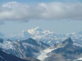
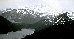
Like many large mountains in the St. Elias Mountains, Mount Fairweather has great vertical relief due to its dramatic rise from Glacier Bay. However, due to poor weather in the area, this effect is usually obscured with the clouds which often hides the summit from view.
Known in the Tlingit language
as Tsalxhaan, it is said this mountain and Yaas'éit'aa Shaa (Mt. St. Elias
) were originally next to each other but had an argument and separated. Their children, the mountains in between the two peaks, are called Tsalxhaan Yatx'i (Children of Tsalxaan.)
each year (mostly snow) and sees temperatures of around -50°F (-46°C).
Pacific Ocean
The Pacific Ocean is the largest of the Earth's oceanic divisions. It extends from the Arctic in the north to the Southern Ocean in the south, bounded by Asia and Australia in the west, and the Americas in the east.At 165.2 million square kilometres in area, this largest division of the World...
on the border of Alaska
Alaska
Alaska is the largest state in the United States by area. It is situated in the northwest extremity of the North American continent, with Canada to the east, the Arctic Ocean to the north, and the Pacific Ocean to the west and south, with Russia further west across the Bering Strait...
, United States
United States
The United States of America is a federal constitutional republic comprising fifty states and a federal district...
and western British Columbia
British Columbia
British Columbia is the westernmost of Canada's provinces and is known for its natural beauty, as reflected in its Latin motto, Splendor sine occasu . Its name was chosen by Queen Victoria in 1858...
, Canada
Canada
Canada is a North American country consisting of ten provinces and three territories. Located in the northern part of the continent, it extends from the Atlantic Ocean in the east to the Pacific Ocean in the west, and northward into the Arctic Ocean...
. Most of the mountain lies within Glacier Bay National Park and Preserve
Glacier Bay National Park and Preserve
Glacier Bay National Park is a national park in Alaska. The area around Glacier Bay in southeastern Alaska was first proclaimed a U.S. National Monument on February 25, 1925. It was changed to Glacier Bay National Park and Preserve on Dec. 2, 1980 by the Alaska National Interest Lands Conservation...
in the City and Borough of Yakutat
Yakutat City and Borough, Alaska
Yakutat City and Borough is a unified city-borough in the U.S. state of Alaska. As of the 2010 census, the population was 4035. The name is Tlingit, Yaakwdáat, meaning "the place where canoes rest", but it originally derives from an Eyak name diyaʼqudaʼt and was influenced by the Tlingit word...
, Alaska (USA), though the summit borders Tatshenshini-Alsek Provincial Park, British Columbia
British Columbia
British Columbia is the westernmost of Canada's provinces and is known for its natural beauty, as reflected in its Latin motto, Splendor sine occasu . Its name was chosen by Queen Victoria in 1858...
(Canada), making it the highest point in that province
Provinces and territories of Canada
The provinces and territories of Canada combine to make up the world's second-largest country by area. There are ten provinces and three territories...
. It is also designated as Boundary Peak 164 or as US/Canada Boundary Point #164.
The mountain was named on May 3, 1778 by Captain James Cook
James Cook
Captain James Cook, FRS, RN was a British explorer, navigator and cartographer who ultimately rose to the rank of captain in the Royal Navy...
, apparently for the unusually good weather encountered at the time. The name has been translated into many languages. It was called "Mt. Beautemps" by La Perouse
Jean-François de Galaup, comte de La Pérouse
Jean François de Galaup, comte de Lapérouse was a French Navy officer and explorer whose expedition vanished in Oceania.-Early career:...
(1786, atlas), "Mte. Buen-tiempo" by Galiano
Dionisio Alcalá Galiano
Dionisio Alcalá Galiano was a Spanish naval officer, cartographer, and explorer. He mapped various coastlines in Europe and the Americas with unprecedented accuracy, using new technology such as chronometers...
(1802, map 3), "Gor[a]-Khoroshy-pogody" on Russian Hydrographic Dept. Chart 1378 in 1847, and "G[ora] Fayerveder" by Captain Tebenkov
Mikhail Tebenkov
Mikhail Dmitriyevich Tebenkov, spelt Tebenkof in the United States , was a Russian hydrographer and vice admiral of the Imperial Russian Navy...
(1852, map 7), Imperial Russian Navy. It was called "Schönwetterberg" by Constantin Grewink in 1850 and "Schönwetter Berg" by Justus Perthes
Justus Perthes
Justus Perthes Publishers in Gotha, Germany was established in 1785. Justus Perthes was Publisher of geographic atlases, ‘’Petermann’s Geographische Mitteilungen’’ and also the Almanach de Gotha,...
in 1882.
Fairweather was first climbed in 1931 by Allen Carpé and Terris Moore.
Geography
Mount Fairweather is located right above Glacier BayGlacier Bay
Glacier Bay Basin in southeastern Alaska, United States, encompasses the Glacier Bay and surrounding mountains and glaciers, which was first proclaimed a U.S. National Monument on February 25, 1925 and which was later, on Dec...
in the Fairweather Range
Fairweather Range
The Fairweather Range is the unofficial name for a mountain range located in the U.S. state of Alaska and the Canadian province of British Columbia. It is the southernmost range of the Saint Elias Mountains...
of the
Saint Elias Mountains
Saint Elias Mountains
The Saint Elias Mountains are a subgroup of the Pacific Coast Ranges, located in southeastern Alaska in the United States, southwestern Yukon and the very far northwestern part of British Columbia in Canada. The range spans Wrangell-St. Elias National Park and Preserve in the USA and Kluane...
. Mount Fairweather also marks the northwest extremity of the Alaska Panhandle
Alaska Panhandle
Southeast Alaska, sometimes referred to as the Alaska Panhandle, is the southeastern portion of the U.S. state of Alaska, which lies west of the northern half of the Canadian province of British Columbia. The majority of Southeast Alaska's area is part of the Tongass National Forest, the United...
.
Like many large mountains in the St. Elias Mountains, Mount Fairweather has great vertical relief due to its dramatic rise from Glacier Bay. However, due to poor weather in the area, this effect is usually obscured with the clouds which often hides the summit from view.
Known in the Tlingit language
Tlingit language
The Tlingit language ) is spoken by the Tlingit people of Southeast Alaska and Western Canada. It is a branch of the Na-Dené language family. Tlingit is very endangered, with fewer than 140 native speakers still living, all of whom are bilingual or near-bilingual in English...
as Tsalxhaan, it is said this mountain and Yaas'éit'aa Shaa (Mt. St. Elias
Mount Saint Elias
Mount Saint Elias, also designated Boundary Peak 186, is the second highest mountain in both Canada and the United States, being situated on the Yukon and Alaska border. It lies about southwest of Mount Logan, the highest mountain in Canada. The Canadian side is part of Kluane National Park,...
) were originally next to each other but had an argument and separated. Their children, the mountains in between the two peaks, are called Tsalxhaan Yatx'i (Children of Tsalxaan.)
Weather
Despite its name, Mount Fairweather has generally harsh weather conditions. It receives over 100 inches (254 cm) of precipitationPrecipitation (meteorology)
In meteorology, precipitation In meteorology, precipitation In meteorology, precipitation (also known as one of the classes of hydrometeors, which are atmospheric water phenomena is any product of the condensation of atmospheric water vapor that falls under gravity. The main forms of precipitation...
each year (mostly snow) and sees temperatures of around -50°F (-46°C).
Climbing history
- 1931 Allen Carpe and Terris Moore summited via the Southeast Ridge on June 8, 1931
- 1958 Paddy Sherman and 7 other Canadians reached the summit via the SE Ridge on June 26, 1958.
- 1968 West Ridge, Loren Adkins, Walter Gove, Paul Myhre, John Neal and Kent Stokes - summit reached June 12, 1968
- 1973 Southwest Ridge, Peter Metcalf, Henry Florschutz, Toby O'Brien and Lincoln Stoller. Summit reached on 10 July 1973.
See also
- 4000 meter peaks of Alaska
- 4000 metre peaks of Canada
- 4000 meter peaks of North America
- 4000 meter peaks of the United States
- Mountain peaks of AlaskaMountain peaks of AlaskaThis article comprises three sortable tables of mountain peaks of the U.S. State of Alaska.Topographic elevation is the vertical distance above the reference geoid, a precise mathematical model of the Earth's sea level as an equipotential gravitational surface. Topographic prominence is the...
- Mountain peaks of CanadaMountain peaks of CanadaThis article comprises three sortable tables of major mountain peaks of Canada.Topographic elevation is the vertical distance above the reference geoid, a precise mathematical model of the Earth's sea level as an equipotential gravitational surface. Topographic prominence is the elevation...
- Mountain peaks of North AmericaMountain peaks of North AmericaThis article comprises three sortable tables of major mountain peaks of greater North America.This article defines greater North America as the portion of the continental landmass of the Americas extending northward from Panama plus the islands surrounding that landmass...
- Mountain peaks of the United StatesMountain peaks of the United StatesThis article comprises three sortable tables of the major mountain peaks of the United States of America.Topographic elevation is the vertical distance above the reference geoid, a precise mathematical model of the Earth's sea level as an equipotential gravitational surface...
- NOAA Ship Fairweather
- List of Boundary Peaks of the Alaska – British Columbia/Yukon border