

Alaska Peninsula
Encyclopedia
Peninsula
A peninsula is a piece of land that is bordered by water on three sides but connected to mainland. In many Germanic and Celtic languages and also in Baltic, Slavic and Hungarian, peninsulas are called "half-islands"....
extending about 800 km (497 mi) to the southwest from the mainland of Alaska
Alaska
Alaska is the largest state in the United States by area. It is situated in the northwest extremity of the North American continent, with Canada to the east, the Arctic Ocean to the north, and the Pacific Ocean to the west and south, with Russia further west across the Bering Strait...
and ending in the Aleutian Islands. The peninsula separates the Pacific Ocean from Bristol Bay
Bristol Bay
Bristol Bay is the eastern-most arm of the Bering Sea, at 57° to 59° North 157° to 162° West in Southwest Alaska. Bristol Bay is 400 km long and 290 km, wide at its mouth...
, an arm of the Bering Sea
Bering Sea
The Bering Sea is a marginal sea of the Pacific Ocean. It comprises a deep water basin, which then rises through a narrow slope into the shallower water above the continental shelves....
.
In literature (especially Russian) the term ‘Alaska Peninsula’ was used to denote the northwest part of North America
North America
North America is a continent wholly within the Northern Hemisphere and almost wholly within the Western Hemisphere. It is also considered a northern subcontinent of the Americas...
, or all of what is now the state of Alaska
Alaska
Alaska is the largest state in the United States by area. It is situated in the northwest extremity of the North American continent, with Canada to the east, the Arctic Ocean to the north, and the Pacific Ocean to the west and south, with Russia further west across the Bering Strait...
with the exception of the Aleutian Islands and the Alaska Panhandle
Alaska Panhandle
Southeast Alaska, sometimes referred to as the Alaska Panhandle, is the southeastern portion of the U.S. state of Alaska, which lies west of the northern half of the Canadian province of British Columbia. The majority of Southeast Alaska's area is part of the Tongass National Forest, the United...
.
Geography
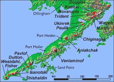
The Aleutian RangeAleutian Range
The Aleutian Range is a major mountain range of southwest Alaska, extending from Chakachamna Lake to Unimak Island, at the tip of the Alaska Peninsula. It includes all of the mountains of the Peninsula. It is especially notable for its large number of active volcanoes, which are also part of the...
is a highly active volcanic
Volcano
2. Bedrock3. Conduit 4. Base5. Sill6. Dike7. Layers of ash emitted by the volcano8. Flank| 9. Layers of lava emitted by the volcano10. Throat11. Parasitic cone12. Lava flow13. Vent14. Crater15...
mountain range
Mountain range
A mountain range is a single, large mass consisting of a succession of mountains or narrowly spaced mountain ridges, with or without peaks, closely related in position, direction, formation, and age; a component part of a mountain system or of a mountain chain...
which runs along the entire length of the Peninsula. Within the and Wildlife Refuges, including the Katmai National Park and Preserve
Katmai National Park and Preserve
Katmai National Park and Preserve is a United States National Park in southern Alaska, notable for the Valley of Ten Thousand Smokes and for its brown bears. The park covers , being roughly the size of Wales. Most of this is a designated wilderness area, including of the park...
, the Aniakchak National Monument and Preserve
Aniakchak National Monument and Preserve
Aniakchak National Monument and Preserve is a U.S. National Monument and National Preserve, consisting of the region around the Aniakchak volcano on the Aleutian Range of south-western Alaska....
and the Becharof National Wildlife Refuge
Becharof National Wildlife Refuge
Becharof National Wildlife Refuge is a National Wildlife Refuge in the Aleutian Range of the Alaska Peninsula of southwestern Alaska. Becharof National Wildlife Refuge, which covers an area of , was established in 1980 to conserve major brown bears, salmon, migratory birds, caribou, marine birds,...
, the Alaska Peninsula National Wildlife Refuge
Alaska Peninsula National Wildlife Refuge
The Alaska Peninsula National Wildlife Refuge is a United States National Wildlife Refuge in southwestern Alaska whose use is regulated as an ecological-protection measure. It stretches along the southern coast of the Alaska Peninsula, between the Becharof National Wildlife Refuge on its east and...
, and the Izembek National Wildlife Refuge
Izembek National Wildlife Refuge
The Izembek National Wildlife Refuge is the smallest of the National Wildlife Refuges located in the U.S. state of Alaska. It lies on the northwest coastal side of central Aleutians East Borough. Most of the refuge was designated as Wilderness in 1980 under the Alaska National Interest Lands...
.
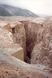
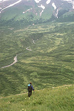
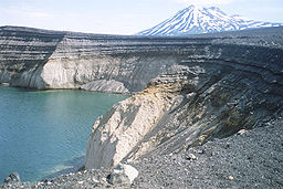
The southern side of the Alaska Peninsula is rugged and mountainous, created by the uplifting tectonic activity of the North Pacific Plate
Pacific Plate
The Pacific Plate is an oceanic tectonic plate that lies beneath the Pacific Ocean. At 103 million square kilometres, it is the largest tectonic plate....
subsiding under a western section of the North American Plate
North American Plate
The North American Plate is a tectonic plate covering most of North America, Greenland, Cuba, Bahamas, and parts of Siberia, Japan and Iceland. It extends eastward to the Mid-Atlantic Ridge and westward to the Chersky Range in eastern Siberia. The plate includes both continental and oceanic crust...
; the northern side is generally flat and marshy, a result of millennia of erosion
Erosion
Erosion is when materials are removed from the surface and changed into something else. It only works by hydraulic actions and transport of solids in the natural environment, and leads to the deposition of these materials elsewhere...
and general seismic stability. The northern and southern shores are likewise quite different. The northern Bristol Bay
Bristol Bay
Bristol Bay is the eastern-most arm of the Bering Sea, at 57° to 59° North 157° to 162° West in Southwest Alaska. Bristol Bay is 400 km long and 290 km, wide at its mouth...
coastal side is generally turbid and muddy, experiences tidal extremes, and is relatively shallow; the Pacific side has relatively small tidal activity and is deep and clear.
Administration
All of the Peninsula is organized as a part of four adjacent boroughsCounty (United States)
In the United States, a county is a geographic subdivision of a state , usually assigned some governmental authority. The term "county" is used in 48 of the 50 states; Louisiana is divided into parishes and Alaska into boroughs. Parishes and boroughs are called "county-equivalents" by the U.S...
; the Aleutians East Borough, Bristol Bay Borough, Kodiak Island Borough, and Lake and Peninsula Borough; and also the entire small Bristol Bay Borough. The Lake and Peninsula Borough includes most of the peninsula's territory.
Climate
Average annual precipitation ranges from 24 to 65 in (610 to 1,650 mm). Coastal areas are subject to intense storms, wind, and rain. Winter temperatures average between -11°C and 1°C, and in summer between 6°C and 15°. Frosts can occur any day of the year at higher elevations. The climate can be compared to that of the Aleutian Islands, IcelandIceland
Iceland , described as the Republic of Iceland, is a Nordic and European island country in the North Atlantic Ocean, on the Mid-Atlantic Ridge. Iceland also refers to the main island of the country, which contains almost all the population and almost all the land area. The country has a population...
, and Tierra del Fuego
Tierra del Fuego
Tierra del Fuego is an archipelago off the southernmost tip of the South American mainland, across the Strait of Magellan. The archipelago consists of a main island Isla Grande de Tierra del Fuego divided between Chile and Argentina with an area of , and a group of smaller islands including Cape...
.
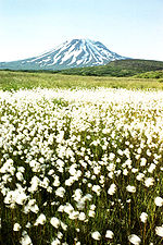
Flora and fauna
The Alaska Peninsula is home to some of the largest populations of native and undisturbed wildlife in the United States. Besides the famous McNeil RiverMcNeil River
The McNeil River is a river on the eastern drainage of the Alaska Peninsula near its base and conjunction with the Alaska mainland. Its entire length of 35 miles lies within the McNeil River State Game Sanctuary, created in 1967 by the State of Alaska to protect the numerous Alaska brown bears who...
and Katmai
Katmai National Park and Preserve
Katmai National Park and Preserve is a United States National Park in southern Alaska, notable for the Valley of Ten Thousand Smokes and for its brown bears. The park covers , being roughly the size of Wales. Most of this is a designated wilderness area, including of the park...
brown bear
Brown Bear
The brown bear is a large bear distributed across much of northern Eurasia and North America. It can weigh from and its largest subspecies, the Kodiak Bear, rivals the polar bear as the largest member of the bear family and as the largest land-based predator.There are several recognized...
populations, large herds of caribou, moose
Moose
The moose or Eurasian elk is the largest extant species in the deer family. Moose are distinguished by the palmate antlers of the males; other members of the family have antlers with a dendritic configuration...
, wolves and waterfowl inhabit the area. The bears of the peninsula and Bristol Bay
Bristol Bay
Bristol Bay is the eastern-most arm of the Bering Sea, at 57° to 59° North 157° to 162° West in Southwest Alaska. Bristol Bay is 400 km long and 290 km, wide at its mouth...
are so numerous because they feed on the world's largest sockeye salmon
Sockeye salmon
Sockeye salmon , also called red salmon or blueback salmon in the USA, is an anadromous species of salmon found in the Northern Pacific Ocean and rivers discharging into it...
Oncorhynchus nerka runs, which occur here in large part because the many large lakes of the peninsula are an important element in their lifecycle. These salmon, after returning from their short life at sea, swim into the lakes and their contributing streams to spawn. Their offspring, or fry, overwinter in the deep and food-abundant depths of these lakes until their migration to the sea in one or two years.
Exceptionally large seabird colonies exist along the coast.
The rugged southern half of the peninsula, and also the Kodiak Archipelago
Kodiak Archipelago
The Kodiak Archipelago is an archipelago, or group of islands, south of main land mass of the state of Alaska , about by air south of Anchorage in the Gulf of Alaska. The largest island in the archipelago is Kodiak Island, the second largest island in the United States...
which lie off the south coast of the peninsula and are home to even more bears, constitute the Alaska Peninsula montane taiga
Alaska Peninsula montane taiga
The Alaska Peninsula montane taiga ecoregion, in the Taiga and Boreal forests Biome, located in North America and defined by the World Wildlife Fund categorization system.-Setting:...
ecoregion
Ecoregion
An ecoregion , sometimes called a bioregion, is an ecologically and geographically defined area that is smaller than an ecozone and larger than an ecosystem. Ecoregions cover relatively large areas of land or water, and contain characteristic, geographically distinct assemblages of natural...
and contain a number of protected areas such as Katmai National Park.
Demographics
Besides the communities on the (see: Bristol BayBristol Bay
Bristol Bay is the eastern-most arm of the Bering Sea, at 57° to 59° North 157° to 162° West in Southwest Alaska. Bristol Bay is 400 km long and 290 km, wide at its mouth...
) coast, the Alaska Peninsula also is home to several well-known villages: Cold Bay
Cold Bay, Alaska
Cold Bay is a city in Aleutians East Borough, Alaska, United States.Cold Bay is one of the main commercial centers of the Alaska Peninsula, and is home to Cold Bay Airport.-History:...
, King Cove
King Cove, Alaska
King Cove is a city in Aleutians East Borough, Alaska, United States. At the 2000 census the population was 792.-Geography:...
, Perryville
Perryville, Alaska
Perryville is a census-designated place in Lake and Peninsula Borough, Alaska, United States. The population was 107 at the 2000 census.-Geography:Perryville is located at ....
, Chignik
Chignik, Alaska
-External links:* / by Mark A. Stichert. Hosted by the ....
, Chignik Lake
Chignik Lake, Alaska
Chignik Lake is a census-designated place in Lake and Peninsula Borough, Alaska, United States. At the 2000 census the population was 145.-Geography:Chignik Lake is located at ....
, Chignik Lagoon
Chignik Lagoon, Alaska
Chignik Lagoon is a census-designated place in Lake and Peninsula Borough, Alaska, United States. At the 2000 census the population was 103.-Geography:Chignik Lagoon is located at ....
, and Port Moller. Each is primarily inhabited by Alaska Natives
Alaska Natives
Alaska Natives are the indigenous peoples of Alaska. They include: Aleut, Inuit, Tlingit, Haida, Tsimshian, Eyak, and a number of Northern Athabaskan cultures.-History:In 1912 the Alaska Native Brotherhood was founded...
and each, likewise, is mostly dependent on the fishing industry for sustinance.
The village of Sand Point
Sand Point, Alaska
Sand Point, also known as Qagun Tayagungin, is a city in Aleutians East Borough, Alaska, United States. At the 2000 census the population was 952. In 2009, the population was 962. It is located on northwestern Popof Island, off the Alaska Peninsula...
should be included here, despite its location on Popof Island, an island of the Sumagin Islands, just off the southern coast of the Peninsula.