
Gareloi Island
Encyclopedia
Volcano
2. Bedrock3. Conduit 4. Base5. Sill6. Dike7. Layers of ash emitted by the volcano8. Flank| 9. Layers of lava emitted by the volcano10. Throat11. Parasitic cone12. Lava flow13. Vent14. Crater15...
island
Island
An island or isle is any piece of sub-continental land that is surrounded by water. Very small islands such as emergent land features on atolls can be called islets, cays or keys. An island in a river or lake may be called an eyot , or holm...
in the Delarof Islands
Delarof Islands
The Delarof Islands are a group of small islands at the extreme western end of the Andreanof Islands group in the central Aleutian Islands, Alaska...
of the Aleutian Islands of Alaska
Alaska
Alaska is the largest state in the United States by area. It is situated in the northwest extremity of the North American continent, with Canada to the east, the Arctic Ocean to the north, and the Pacific Ocean to the west and south, with Russia further west across the Bering Strait...
. It is located between the Tanaga Pass
Tanaga Pass
The Tanaga Pass is a strait between Tanaga Island and the Delarof Islands the Aleutian Islands of Alaska. It is about 40 miles long and 13 miles wide at its narrowest part. Tidal currents commonly range between 2 and 3 knots in the pass.From the U.S...
and the Amchitka Pass
Amchitka Pass
Amchitka Pass is a strait in Alaska, United States. It is located in the Aleutian Islands, between the Rat Islands group to the west and the Delarof Islands to the east. Amchitka Pass has a least width of 50 miles and depths of 49 to over 1,000 fathoms. The islands on both sides of the pass should...
.
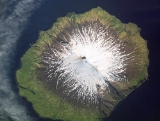
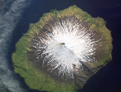
The island is 6 miles (9.7 km) in length and 5 miles (8 km) wide. Its land area is 25.95 square miles (67.2 km²), making Gareloi the largest island in the Delarof group. Gareloi Volcano
Gareloi Volcano
The Gareloi Volcano is a stratovolcano in the Aleutian Islands of Alaska, USA, about from Anchorage. Gareloi is located on Gareloi Island, and comprises most of its land mass. The island also has two small glaciers which protrude to the northwest and southeast....
, a stratovolcano
Stratovolcano
A stratovolcano, also known as a composite volcano, is a tall, conical volcano built up by many layers of hardened lava, tephra, pumice, and volcanic ash. Unlike shield volcanoes, stratovolcanoes are characterized by a steep profile and periodic, explosive eruptions...
, is situated in the center of the island which reaches a height of 5161 feet (1,573.1 m). On the other side of a small saddle lies another peak of the island however it does not equal the height of Mount Gareloi. The island is uninhabited.
Coastal cliffs provide nesting habitat for more than 600,000 seabirds, mostly for crevice nesting auklets. Least Auklets account for 62% of the colony, Crested Auklets for 30%, and Parakeet Auklets for 6%. Each of these species is present on the island in numbers exceeding 1% of their global populations.
The island consists of lava rock, black lava, eroded lava, and ashes; the lower slopes and valleys are covered with grass and tundra in many places. The shores have steep cliffs with rocks and boulders at the base; boulders, pinnacles, and rocks awash extend around the shoreline. Heavy kelp surrounds most of the island, and extends offshore to 10 fathoms. Depths of 10 fathoms or more are within 0.5 mile of the island. A trapper’s hut is on the beach above the N shore of Gareloi Island.
Gareloi's northern, slightly higher peak is on the southern rim of a crater about 300 meters across, which contains several active fumaroles. Thirteen younger craters, from 80 to 1600 m in diameter, are aligned along a south-southeast trending fissure that extends from strandline to the southern summit. These craters formed during a major explosive eruption in 1929 that also produced four blocky lava flows, and a blanket of grassy andesitic tuff that covers an area roughly 1.5 x 3 miles on the volcano's southeast flank.
Gareloi Volcano had four confirmed eruptions in the 1980s and one unconfirmed eruption in 1996. All but one of them were considered explosive eruptions. In Spring and Summer 2007 there was a period of increased seismic activity on Gareloi Island, sometimes reaching 40 earthquakes per day.
External links
- Gareloi Volcano Photographs from Gareloi Island, July 2008.