

Driver location signs
Encyclopedia
England
England is a country that is part of the United Kingdom. It shares land borders with Scotland to the north and Wales to the west; the Irish Sea is to the north west, the Celtic Sea to the south west, with the North Sea to the east and the English Channel to the south separating it from continental...
highway route markers
Highway route markers
Highway route markers are the modern-day equivalent of milestones. Unlike traditional milestones, however, which were originally carved from stone and sited at one-mile intervals, modern highway route markers are made from a variety of materials and are almost invariably spaced at intervals of a...
, first introduced in 2003, that complement distance marker posts. Both types of marker post display the distances from a nominal (as opposed to a physical) start point in kilometres. Driver location signs are designed to be read by motorist when, for instance, then need to passing details to the emergency services while distance marker posts are designed for administrative purposes.
Distance marker posts
Since at least 1980, major dual-carriageway roads (including motorways) have had distance marker posts installed at 100 metres (109.4 yd) intervals. These posts are used to help identify road locations for maintenance and emergency service purposes. The figures on the posts give the distance of the post, in kilometres, from a reference point such as a city centre, an administrative boundary or some other point. On the M25M25 motorway
The M25 motorway, or London Orbital, is a orbital motorway that almost encircles Greater London, England, in the United Kingdom. The motorway was first mooted early in the 20th century. A few sections, based on the now abandoned London Ringways plan, were constructed in the early 1970s and it ...
for example, distances are referenced to a point near Junction 31 even though the section of the ring road between Junction 31 (186.6 km) and Junction 1a (5.7 km) is the A282
A282 road
The A282 is a road that includes the Dartford Crossing across the River Thames between Essex and Kent in England. It forms part of the London Orbital connecting junctions 2 and 31 of the M25, and a part of the unsigned Euroroute E15. It has junctions numbered to fit inside the sequence of the M25...
, not the M25.
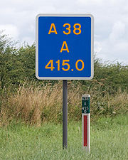
On motorways distance marker posts also bear an arrow pointing towards the location of the nearest emergency telephone. The marker post pictured here is on a trunk road
Trunk road
A trunk road, trunk highway, or strategic road is a major road—usually connecting two or more cities, ports, airports, and other things.—which is the recommended route for long-distance and freight traffic...
, not a motorway, and hence has no arrow. It is, however, unusual in displaying the highway identifier (A38) and carriageway identifier (A) in addition to the location identification (415.0).
The location denoted by distance marker posts is encoded into the numbers associated with motorway emergency roadside telephones. In this way the motorway control centre staff can quickly and accurately identify the location of the telephone from which the caller was reporting an incident.
Almost all items of highway furniture
Street furniture
Street furniture is a collective term for objects and pieces of equipment installed on streets and roads for various purposes, including traffic barriers,...
can be uniquely identified by number that are attached to or stencilled onto them. On motorways the number on the closest distance location marker is often incorporated into such identifiers. They are also used to identify traffic camera displays that can be seen at certain motorway service area
Motorway service area
In the UK motorway service areas, also known as service stations, are places where drivers can leave a motorway to refuel, rest, or take refreshments. The vast majority of motorway services in the UK are owned by one of three companies: Moto, Welcome Break and RoadChef. Extra are also developing a...
s and on the internet.
Driver location signs
These signs give the same location information as distance marker posts, but in a more visible way on larger signs, which are generally placed at 500 metres (546.8 yd) intervals.The need for more visible roadside locatation information was shown in 2007, in an incident on a motorway section before driver location signs had been erected. The Devon and Somerset Fire & Rescue Service reported that after a serious collision on the M5
M5 motorway
The M5 is a motorway in England. It runs from a junction with the M6 at West Bromwich near Birmingham to Exeter in Devon. Heading south-west, the M5 runs east of West Bromwich and west of Birmingham through Sandwell Valley...
, their control centre was inundated with mobile phone calls from drivers. Callers gave the operators locations stretching over 40 miles (64.4 km) of road. As a result, four emergency service centres were mobilised instead of just one.
Research on trial sections of motorways showed that emergency service organisations responded 10 percent more quickly when a motorway had driver location signs than when it did not. Driver locations signs are more visible than the distance marker posts; this enables motorists to identify their location more quickly and accurately. Therefore emergency services can get to emergencies more quickly.
By the early 2000s mobile phones were being used as the primary means of reporting accidents
.
This required the government to rethink marker posts. By early 2007, after experiments from 2003 onwards on parts of the M25
M25 motorway
The M25 motorway, or London Orbital, is a orbital motorway that almost encircles Greater London, England, in the United Kingdom. The motorway was first mooted early in the 20th century. A few sections, based on the now abandoned London Ringways plan, were constructed in the early 1970s and it ...
and M6
M6 motorway
The M6 motorway runs from junction 19 of the M1 at the Catthorpe Interchange, near Rugby via Birmingham then heads north, passing Stoke-on-Trent, Manchester, Preston, Carlisle and terminating at the Gretna junction . Here, just short of the Scottish border it becomes the A74 which continues to...
which showed a 10% improvement in emergency service response times, a programme to erect driver location signs was commenced in England, but not in Scotland, Wales or Northern Ireland), at 500 intervals on many motorways. If obstacles prevent signs from being spaced at 500 metres (546.8 yd) intervals, then the interval must be reduced to either 400 or. By the end of the 2009 financial year, 80 percent of England's motorway network had been fitted with 16,000 driver location signs at a cost of £5.9 million (about £570 each). It was expected that the remaining 20% of the motorway network would be covered by April 2010 at a cost of £1.6 million.
Driver location signs have three pieces of information:
- The road identifier
- The carriageway identifier
- The location
The location is identical to the location given on marker posts. The most commonly used carriageway identifiers are the letters “A”, “B”, “J”, “K”, “L” and “M”.
The letter “A” normally denotes the carriageways leaving London (or clockwise in the case of the M25) and "B" is used for the opposite carriageway. Location numbers usually (but not always) increase in the direction of travel of the "A" carriageway, and decrease in the direction of travel of the "B" the carriageway. The letters "J", "K", "L" and "M" denote junction slip roads. This is illustrated below.
Letters "C" and "D" have been allocated for service roads adjacent to the "A" and "B" carriageways. The regulations require that each driver location sign be unique within the United Kingdom.
The analysis of an exercise run by the Highways Agency (Exercise Hermes) in which a serious traffic accident was simulated reported that call handlers in control rooms should request marker post or location sign locations when taking calls from members of the public.
Rerouting
If a road is rerouted, then it is highly likely that there will be some changes in the end-to-end length of the road concerned which could affect the valuesMilepost equation
A milepost equation, milepoint equation, or postmile equation is a place where mileposts on a linear feature, such as a highway or rail line, fail to increase normally, usually due to realignment or changes in planned alignment...
on driver location signs. The publicly available Highways Agency documentation does not cover this possibility, but it will be noticed that the four carriageway identifiers "E", "F", "G" and "H" have been not been allocated.