
.gif)
Red Line (Washington Metro)
Encyclopedia
The Red Line of the Washington Metro
is a rail rapid transit
service operating between 27 stations
in Montgomery County
, Maryland
and the District of Columbia, United States
. It is a primary line through downtown Washington, and the oldest and busiest line in the system. It forms a long, narrow "U" capped by its terminal stations at Shady Grove and Glenmont.
It is the only line which does not share its track with any other line, except from January 27, 1997 to September 17, 1999, when the Green Line Commuter Shortcut used Red Line tracks from Brookland–CUA to Farragut North. Unique among the Washington Metro train lines, some peak service Red Line trains operate on an abbreviated route, between Grosvenor–Strathmore and Silver Spring. On April 20, 2006, the Washington Metropolitan Area Transit Authority
(WMATA), Montgomery County, and the state of Maryland announced an agreement to end the off-peak terminations at Grosvenor, having those trains operate instead between Shady Grove and Silver Spring. It provides service at 6 minute intervals
during the day and 12 minute intervals in the evening. The Red Line is undergoing a $212 million improvement program.
With the formation of WMATA in October 1966, planning of the system shifted from federal hands to a regional body with representatives of the District, Maryland and Virginia. Corngressional route approval was no longer a key consideration. Instead, routes had to serve each local suburban jurisdiction to assure that they would approve bond referenda to finance the system. Because the least expensive way to build into the suburbs was to rely upon existing railroad right-of-ways, the Red Line took much of its present form, except that it continued to feature a further link between its two stems along the Baltimore & Ohio Railroad right-of-way.
By 1969, WMATA had decided on the current routing and stations, except for the extension beyond Rockville to Shady Grove. Funding for the extension to Shady Grove was conditionally approved in July 1975. Construction on the Red Line began with a groundbreaking ceremony on December 9, 1969. Construction proved difficult because the National Park Service
prohibited a bridge across Rock Creek
and required that the Red Line tunnel under that valley, The tunnel in turn caused both the DuPont Circle and Woodley Park stations to be built further underground. The Red Line was proposed to tunnel under Yuma Street from Connecticut Avenue to Wisconsin Avenue, but local residents sued, and that court case delayed construction of the tunnel for two years, although WMATA finally won the right to build the tunnel there.
Service on the Red Line (and the Metro as a whole) began on March 29, 1976, with operations between Farragut North and Rhode Island Avenue – Brentwood. Gallery Place's opening was delayed due to a court order regarding lack of handicapped access, but it opened in the middle of the line on December 15, 1976. The western end of the line was extended one station to Dupont Circle on January 17, 1977, three stations to Van Ness – UDC on December 5, 1981, five stations to Grosvenor–Strathmore on August 25, 1984, and four stations to Shady Grove on December 15, 1984. The eastern end was extended four stations to Silver Spring on February 6, 1978 – which added Maryland to the system for the first time – two stations to Wheaton on September 22, 1990, and one station to Glenmont on July 25, 1998, completing the line.
A short time after the Green Line
branch north of Fort Totten opened in the early 1990s, the Green Line Commuter Shortcut began as a six-month experiment. Passengers could board the Green Line between Greenbelt and West Hyattsville and travel as far as Farragut North without having to transfer; the trains bypassed Fort Totten via a single-track spur between the West Hyattsville and Brookland–CUA stations. Due to its success, the shortcut continued until the mid-city portion of the Green Line was completed in 1999.
The NoMa – Gallaudet University station, located between Union Station and Rhode Island Avenue – Brentwood, opened on November 20, 2004. It was the system's first in-fill station (i.e., a new station built between existing stations).
 On November 3, 2004, an out-of-service Red Line train rolled backwards into the Woodley Park – Zoo / Adams Morgan station and hit an in-service train stopped at the platform. No one was killed, but 20 people were injured. A 14-month investigation concluded that the train operator was most likely not alert as the train rolled backwards into the station. Safety officials estimated that had the train been full, at least 79 would have died. The train operator was dismissed and Metro officials agreed to add rollback protection to more than 300 rail cars.
's Metropolitan Subdivision (served by MARC
Brunswick Line trains) to south of Twinbrook. The Red Line then enters a tunnel and curves west to run under Rockville Pike at White Flint. Until Tenleytown, the Red Line follows the route of Rockville Pike and Wisconsin Avenue, in a tunnel except for a bridge over the Washington Beltway (I-495). The tunnel curves east at Tenleytown into Yuma Street to reach the Van Ness-UDC station, curving south there under Connecticut Avenue to south of Farragut Square
. A curve under Lafayette Park takes the tunnel east under G Street Northwest through the Metro Center station and the Gallery Place – Chinatown station.
From Gallery Place – Chinatown through Judiciary Square, the line runs southeast, turning east again at D Street to reach Union Station
. There it turns north and surfaces adjacent to Union Station's platforms, follows the Washington Terminal yard tracks north to Brentwood
where the line turns northwestward and again joins CSX Transportation
's Metropolitan Subdivision tracks, running in a unique gauntlet arrangement with the freight railroad tracks straddling the Metro tracks. The Red Line continues in this manner northwest across the District-Maryland line, through Takoma and past Silver Spring
. It reenters a tunnel at 16th Street Northwest and heads north under Georgia Avenue
to the end at Glenmont
. There is a maintenance yard between the Florida Avenue and Rhode Island Avenue stops.
The following stations are along the line, from northwest to northeast.
Internally, the Red Line is known as the Shady Grove Route (A) and the Glenmont Route (B), which meet at Metro Center.
The Red Line needs 44 trains (10 eight-car trains and 34 six-car trains, consisting of 284 rail cars) to run at peak capacity Trains leave at 6 minute intervals during the mid-day and 12 minute intervals during the evenings.
Montgomery County has submitted a federal $20 million grant application to build a pedestrian tunnel under Wisconsin Avenue to improve access to the Medical Center stop. If funded, construction would occur in 2011.
Washington Metro
The Washington Metro, commonly called Metro, and unofficially Metrorail, is the rapid transit system in Washington, D.C., United States, and its surrounding suburbs. It is administered by the Washington Metropolitan Area Transit Authority , which also operates Metrobus service under the Metro name...
is a rail rapid transit
Rapid transit
A rapid transit, underground, subway, elevated railway, metro or metropolitan railway system is an electric passenger railway in an urban area with a high capacity and frequency, and grade separation from other traffic. Rapid transit systems are typically located either in underground tunnels or on...
service operating between 27 stations
Metro station
A metro station or subway station is a railway station for a rapid transit system, often known by names such as "metro", "underground" and "subway". It is often underground or elevated. At crossings of metro lines, they are multi-level....
in Montgomery County
Montgomery County, Maryland
Montgomery County is a county in the U.S. state of Maryland, situated just to the north of Washington, D.C., and southwest of the city of Baltimore. It is one of the most affluent counties in the United States, and has the highest percentage of residents over 25 years of age who hold post-graduate...
, Maryland
Maryland
Maryland is a U.S. state located in the Mid Atlantic region of the United States, bordering Virginia, West Virginia, and the District of Columbia to its south and west; Pennsylvania to its north; and Delaware to its east...
and the District of Columbia, United States
United States
The United States of America is a federal constitutional republic comprising fifty states and a federal district...
. It is a primary line through downtown Washington, and the oldest and busiest line in the system. It forms a long, narrow "U" capped by its terminal stations at Shady Grove and Glenmont.
It is the only line which does not share its track with any other line, except from January 27, 1997 to September 17, 1999, when the Green Line Commuter Shortcut used Red Line tracks from Brookland–CUA to Farragut North. Unique among the Washington Metro train lines, some peak service Red Line trains operate on an abbreviated route, between Grosvenor–Strathmore and Silver Spring. On April 20, 2006, the Washington Metropolitan Area Transit Authority
Washington Metropolitan Area Transit Authority
The Washington Metropolitan Area Transit Authority is a tri-jurisdictional government agency that operates transit service in the Washington, D.C. metropolitan area, including the Metrorail, Metrobus and MetroAccess...
(WMATA), Montgomery County, and the state of Maryland announced an agreement to end the off-peak terminations at Grosvenor, having those trains operate instead between Shady Grove and Silver Spring. It provides service at 6 minute intervals
Headway
Headway is a measurement of the distance/time between vehicles in a transit system. The precise definition varies depending on the application, but it is most commonly measured as the distance from the tip of one vehicle to the tip of the next one behind it, expressed as the time it will take for...
during the day and 12 minute intervals in the evening. The Red Line is undergoing a $212 million improvement program.
History
Planning for Metro began with the Mass Transportation Survey in 1955 which attempted to forecast both freeway and mass transit systems sufficient to meet the needs of 1980. In 1959, the study's final report included two rapid transit lines which anticipated subways in downtown Washington. Because the plan called for extensive freeway construction within the District of Columbia, alarmed residents lobbied for federal legislation creating a moratorium on freeway construction through July 1, 1962. The National Capital Transportation Agency's 1962 Transportation in the National Capital Region report anticipated much of the present Red Line route, with the Red Line following the Baltimore & Ohio Railroad right-of-way between Silver Spring and Rockville instead of a direct route between Bethesda and Rockville. The route continued in rapid transit plans until the formation of WMATA.With the formation of WMATA in October 1966, planning of the system shifted from federal hands to a regional body with representatives of the District, Maryland and Virginia. Corngressional route approval was no longer a key consideration. Instead, routes had to serve each local suburban jurisdiction to assure that they would approve bond referenda to finance the system. Because the least expensive way to build into the suburbs was to rely upon existing railroad right-of-ways, the Red Line took much of its present form, except that it continued to feature a further link between its two stems along the Baltimore & Ohio Railroad right-of-way.
By 1969, WMATA had decided on the current routing and stations, except for the extension beyond Rockville to Shady Grove. Funding for the extension to Shady Grove was conditionally approved in July 1975. Construction on the Red Line began with a groundbreaking ceremony on December 9, 1969. Construction proved difficult because the National Park Service
National Park Service
The National Park Service is the U.S. federal agency that manages all national parks, many national monuments, and other conservation and historical properties with various title designations...
prohibited a bridge across Rock Creek
Rock Creek
-Streams:* Rock Creek * Rock Creek , disambiguation* Rock Creek * Rock Creek , in Illinois* Rock Creek , in Maryland and the District of Columbia* Rock Creek , in Missoula County...
and required that the Red Line tunnel under that valley, The tunnel in turn caused both the DuPont Circle and Woodley Park stations to be built further underground. The Red Line was proposed to tunnel under Yuma Street from Connecticut Avenue to Wisconsin Avenue, but local residents sued, and that court case delayed construction of the tunnel for two years, although WMATA finally won the right to build the tunnel there.
Service on the Red Line (and the Metro as a whole) began on March 29, 1976, with operations between Farragut North and Rhode Island Avenue – Brentwood. Gallery Place's opening was delayed due to a court order regarding lack of handicapped access, but it opened in the middle of the line on December 15, 1976. The western end of the line was extended one station to Dupont Circle on January 17, 1977, three stations to Van Ness – UDC on December 5, 1981, five stations to Grosvenor–Strathmore on August 25, 1984, and four stations to Shady Grove on December 15, 1984. The eastern end was extended four stations to Silver Spring on February 6, 1978 – which added Maryland to the system for the first time – two stations to Wheaton on September 22, 1990, and one station to Glenmont on July 25, 1998, completing the line.
A short time after the Green Line
Green Line (Washington Metro)
The Green Line is one of five heavy rail subway lines that constitute the Washington Metro rapid transit system in the Washington, D.C., metropolitan area. The Green Line consists of 21 stations, with termini at Branch Avenue and at Greenbelt. The Green Line runs through Prince George's County,...
branch north of Fort Totten opened in the early 1990s, the Green Line Commuter Shortcut began as a six-month experiment. Passengers could board the Green Line between Greenbelt and West Hyattsville and travel as far as Farragut North without having to transfer; the trains bypassed Fort Totten via a single-track spur between the West Hyattsville and Brookland–CUA stations. Due to its success, the shortcut continued until the mid-city portion of the Green Line was completed in 1999.
The NoMa – Gallaudet University station, located between Union Station and Rhode Island Avenue – Brentwood, opened on November 20, 2004. It was the system's first in-fill station (i.e., a new station built between existing stations).
2004 Woodley Park accident
2009 train collision
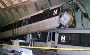
On the afternoon of June 22, 2009, at 5:03 p.m. EDT, two trains on the Red Line collided. A stationary train was struck from behind by a second six-car train, resulting in the telescoping of the moving train onto the rear of the stationary train. Nine people were killed in the collision (eight passengers and the train operator), and at least 70 people were injured. It is the deadliest accident in the history of the Washington Metro. The NTSB report on the accident was released on July 27, 2010, and blamed a faulty track circuit, part of the automatic train control system, for causing the crash. WMATA made a press release detailing changes on July 26 in anticipation of the release.Chronology
Below is a chronological list of dates on which specific portions of the Red Line opened for service.| Date | Event | Total number of stations | Total line length (mi) | Total line length (km) |
|---|---|---|---|---|
| March 29, 1976 | Line opens between Farragut North and Rhode Island Avenue – Brentwood | 5 | 4.6 | 7.4 |
| December 15, 1976 | Gallery Place opens between existing stations | 6 | 4.6 | 7.4 |
| January 1, 1977 | Extension to Dupont Circle opens | 7 | 5.7 | 9.2 |
| February 6, 1978 | Extension to Silver Spring opens | 11 | 11.4 | 18.3 |
| December 5, 1981 | Extension to Van Ness – UDC opens | 14 | 13.5 | 21.7 |
| August 25, 1984 | Extension to Grosvenor–Strathmore opens | 19 | 20.3 | 32.7 |
| December 15, 1984 | Extension to Shady Grove opens | 23 | 27.3 | 43.9 |
| September 22, 1990 | Extension to Wheaton opens | 25 | 30.5 | 49.1 |
| January 25, 1998 | Extension to Glenmont opens | 26 | 31.9 | 51.3 |
| November 20, 2004 | NoMa – Gallaudet University (then New York Avenue–Florida Avenue–Gallaudet University) opens between existing stations | 27 | 31.9 | 51.3 |
Route
The Red Line begins above ground at Shady Grove, and parallels CSX TransportationCSX Transportation
CSX Transportation operates a Class I railroad in the United States known as the CSX Railroad. It is the main subsidiary of the CSX Corporation. The company is headquartered in Jacksonville, Florida, and owns approximately 21,000 route miles...
's Metropolitan Subdivision (served by MARC
MARC Train
MARC , known prior to 1984 as Maryland Rail Commuter Service, is a regional rail system comprising three lines in the Baltimore-Washington Metropolitan Area. MARC is administered by the Maryland Transit Administration , a Maryland Department of Transportation agency, and is operated under contract...
Brunswick Line trains) to south of Twinbrook. The Red Line then enters a tunnel and curves west to run under Rockville Pike at White Flint. Until Tenleytown, the Red Line follows the route of Rockville Pike and Wisconsin Avenue, in a tunnel except for a bridge over the Washington Beltway (I-495). The tunnel curves east at Tenleytown into Yuma Street to reach the Van Ness-UDC station, curving south there under Connecticut Avenue to south of Farragut Square
Farragut Square
Farragut Square is a city square in Washington, D.C.'s Ward 2. It is bordered by K Street NW on the north, I Street NW to the south, and on the east and west by segments of 17th Street NW, and it interrupts Connecticut Avenue NW...
. A curve under Lafayette Park takes the tunnel east under G Street Northwest through the Metro Center station and the Gallery Place – Chinatown station.
From Gallery Place – Chinatown through Judiciary Square, the line runs southeast, turning east again at D Street to reach Union Station
Union Station (Washington, D.C.)
Washington Union Station is a train station and leisure destination visited by 32 million people each year in the center of Washington, D.C. The train station is served by Amtrak, MARC and Virginia Railway Express commuter rail services as well as by Washington Metro subway trains and local buses...
. There it turns north and surfaces adjacent to Union Station's platforms, follows the Washington Terminal yard tracks north to Brentwood
Brentwood, Washington, D.C.
Brentwood is a neighborhood in Northeast Washington, D.C. and is named after the Brentwood Mansion built at Florida Avenue and 6th Street NE in 1817 by Robert Brent, the first mayor of Washington City. He built it as a wedding present for his daughter Eleanor on her marriage as second wife to...
where the line turns northwestward and again joins CSX Transportation
CSX Transportation
CSX Transportation operates a Class I railroad in the United States known as the CSX Railroad. It is the main subsidiary of the CSX Corporation. The company is headquartered in Jacksonville, Florida, and owns approximately 21,000 route miles...
's Metropolitan Subdivision tracks, running in a unique gauntlet arrangement with the freight railroad tracks straddling the Metro tracks. The Red Line continues in this manner northwest across the District-Maryland line, through Takoma and past Silver Spring
Silver Spring, Maryland
Silver Spring is an unincorporated area and census-designated place in Montgomery County, Maryland, United States. It had a population of 71,452 at the 2010 census, making it the fourth most populous place in Maryland, after Baltimore, Columbia, and Germantown.The urbanized, oldest, and...
. It reenters a tunnel at 16th Street Northwest and heads north under Georgia Avenue
Georgia Avenue
Georgia Avenue is a major north-south artery in Northwest Washington, D.C. and Montgomery County, Maryland. Within the District of Columbia and a short distance in Silver Spring, Maryland, Georgia Avenue is also U.S. Route 29...
to the end at Glenmont
Glenmont, Maryland
Glenmont is an unincorporated community in Montgomery County, Maryland, USA. The U.S. Census Bureau combines Glenmont with nearby Wheaton to create the Census Designated Place of Wheaton-Glenmont.- Location :...
. There is a maintenance yard between the Florida Avenue and Rhode Island Avenue stops.
The following stations are along the line, from northwest to northeast.
- Shady Grove
- Rockville
- Twinbrook
- White Flint
- Grosvenor–Strathmore
- Medical Center
- Bethesda
- Friendship Heights
- Tenleytown–AU
- Van Ness – UDC
- Cleveland Park
- Woodley Park
- Dupont Circle
- Farragut North
- Metro Center (transfer station for the BlueBlue Line (Washington Metro)The Blue Line of the Washington Metro in the United States consists of 27 rapid transit stations from Franconia–Springfield to Largo Town Center. It has stations in Fairfax County, Alexandria and Arlington, Virginia, the District of Columbia, and Prince George's County, Maryland...
, OrangeOrange Line (Washington Metro)The Orange Line of the Washington Metro consists of 26 rapid transit stations from Vienna to New Carrollton. It has stations in Fairfax County and Arlington, Virginia, the District of Columbia, and Prince George's County, Maryland. Half of the line's stations are shared with the Blue Line, and over...
, and planned Silver LinesSilver Line (Washington Metro)The Dulles Corridor Metrorail Project, formally dubbed the Silver Line, is an extension of the Washington Metro rapid transit system, currently under construction with the goal of providing rapid transit service to Dulles International Airport and Tysons Corner...
) - Gallery Place (transfer station for the GreenGreen Line (Washington Metro)The Green Line is one of five heavy rail subway lines that constitute the Washington Metro rapid transit system in the Washington, D.C., metropolitan area. The Green Line consists of 21 stations, with termini at Branch Avenue and at Greenbelt. The Green Line runs through Prince George's County,...
and Yellow LinesYellow Line (Washington Metro)The Yellow Line of the Washington Metro consists of 17 rapid transit stations from Huntington to Fort Totten. The line terminates at the Mount Vernon Square station during peak hours.Peak hours are 5 a.m. to 9:30 a.m. and 3 p.m. to 7 p.m. Service is extended to the Green Line stations during...
) - Judiciary Square
- Union Station
- NoMa – Gallaudet University
- Rhode Island Avenue – Brentwood
- Brookland–CUA
- Fort Totten (transfer station for the Green LineGreen Line (Washington Metro)The Green Line is one of five heavy rail subway lines that constitute the Washington Metro rapid transit system in the Washington, D.C., metropolitan area. The Green Line consists of 21 stations, with termini at Branch Avenue and at Greenbelt. The Green Line runs through Prince George's County,...
, and the Yellow LineYellow Line (Washington Metro)The Yellow Line of the Washington Metro consists of 17 rapid transit stations from Huntington to Fort Totten. The line terminates at the Mount Vernon Square station during peak hours.Peak hours are 5 a.m. to 9:30 a.m. and 3 p.m. to 7 p.m. Service is extended to the Green Line stations during...
during off-peak hours) - Takoma
- Silver Spring
- Forest Glen
- Wheaton
- Glenmont
Internally, the Red Line is known as the Shady Grove Route (A) and the Glenmont Route (B), which meet at Metro Center.
The Red Line needs 44 trains (10 eight-car trains and 34 six-car trains, consisting of 284 rail cars) to run at peak capacity Trains leave at 6 minute intervals during the mid-day and 12 minute intervals during the evenings.
Future
In November 2010, WMATA authorized $37 million in capital improvements on the Red Line. This is a part of $212 million of work on the Red Line scheduled over 2010-2014. In December 2009, WMATA began construction of a new 1,200-car parking garage to supplement the existing 1,700-car parking garage at the Glenmont station. The new garage is expected to open in 2011 and was funded by the State of Maryland.Montgomery County has submitted a federal $20 million grant application to build a pedestrian tunnel under Wisconsin Avenue to improve access to the Medical Center stop. If funded, construction would occur in 2011.